Cambridge International Level 3
Pre-U Certificate in
Geography (Principal)
9768
For examination in 2016, 2017 and 2018
Cambridge International Examinations retains the copyright on all its publications. Registered Centres are permitted to copy material from this booklet for their own internal use. However, we cannot give permission to Centres to photocopy any material that is acknowledged to a third party even for internal use within a Centre.
© Cambridge International Examinations 2013
Changes to syllabus for 2016, 2017 and 2018
This syllabus has been revised. Significant changes to the syllabus are indicated by black vertical
lines either side of the text.
The order of the components taken by candidates has been changed. Candidates now take Global
Environments first, followed by Global Themes, Geographical Issues and Research Topic.
The scheme of assessment for Global Environments has changed from essay format to structured
questions and extended writing tasks.
The syllabus content for Global Environments, Global Themes, and Geographical Issues has been
revised and updated. The topic ‘World of Work’ in Global Themes has been replaced by ’People, Place
and Conflicts’.
You are advised to read the whole syllabus before planning your teaching programme.
If there are any further changes to this syllabus, Cambridge will write to Centres to inform them.
This syllabus is also on the Cambridge website www.cie.org.uk/cambridgepreu. The version of the
syllabus on the website should always be considered as the definitive version.
Introduction ... 2
Why choose Cambridge Pre-U?
Why choose Cambridge Pre-U Geography?
Syllabus aims ... 4
Scheme of assessment ... 5
Assessment objectives ... 6
Relationship between scheme of assessment and assessment objectives ... 7
Grading and reporting ... 8
Grade descriptions ... 9
Description of components ... 11
Paper 1 Global Environments
Paper 2 Global Themes
Paper 3 Geographical Issues
Paper 4 Research Topic
Core geographical skills
Syllabus content ... 18
Introduction
Why choose Cambridge Pre-U?
Cambridge Pre-U is designed to equip learners with the skills required to make a success of their studies at
university. Schools can choose from a wide range of subjects.
Cambridge Pre-U is built on a core set of educational aims to prepare learners for university admission, and
also for success in higher education and beyond:
• to support independent and self-directed learning
• to encourage learners to think laterally, critically and creatively, and to acquire good
problem-solving skills
• to promote comprehensive understanding of the subject through depth and rigour.
Cambridge Pre-U Principal Subjects are linear. A candidate must take all the components together at the end
of the course in one examination series. Cambridge Pre-U Principal Subjects are assessed at the end of a
two-year programme of study.
The Cambridge Pre-U nine-point grade set recognises the full range of learner ability.
Guided learning hours
Cambridge Pre-U syllabuses are designed on the assumption that learners have around 380 guided learning
hours per Principal Subject over the duration of the course, but this is for guidance only. The number of
hours may vary according to curricular practice and the learners’ prior experience of the subject.
Why choose Cambridge Pre-U Geography?
• Camridge Pre-U Geography offers opportunities to explore a range of geographical environments,
issues, themes and hazards. Teachers can foster genuine interest in and enjoyment of the subject by
selecting syllabus content which builds on KS4 courses of study and increases interest by avoiding
repetition.
• Cambridge Pre-U Geography emphasises breadth as well as depth of teaching and learning. The syllabus
combines a good grounding in physical processes with challenging and contemporary themes in human
geography which provide the depth and rigour required for a university degree course.
• The syllabus encourages the acquisition of specific geographical skills and abilities, in particular the skills
of independent research, fieldwork, analysis and effective communication.
• The syllabus encourages independent learning, wider reading and understanding of current issues to
support the development of well-informed and independent-minded individuals capable of applying their
skills to meet the demands of the world as they will find it.
Prior learning
Cambridge Pre-U builds on the knowledge, understanding and skills typically gained by candidates taking
Level 1/Level 2 qualifications such as Cambridge IGCSE.
Progression
Cambridge Pre-U is considered to be an excellent preparation for university, employment and life. It helps
to develop the in-depth subject knowledge and understanding which are so important to universities and
employers. The Cambridge Pre-U Geography course aims to equip learners with the skills required to make
a success of their subsequent studies at university, involving not only a solid grounding in specialist subject
knowledge at an appropriate level, but also the ability to undertake independent and self-directed learning
and to think laterally, critically and creatively. Although designed for learners intending to continue their
studies in higher education, the skills fostered also provide solid grounding for learners intending to progress
directly into employment or professional training.
Cambridge Pre-U Diploma
If learners choose, they can combine Cambridge Pre-U qualifications to achieve the Cambridge Pre-U
Diploma; this comprises three Cambridge Pre-U Principal Subjects* together with Global Perspectives and
Research (GPR). The Cambridge Pre-U Diploma, therefore, provides the opportunity for interdisciplinary
study informed by an international perspective and includes an independent research project.
first year
second year
CAMBRIDGE PRE-U DIPLOMA
Cambridge Pre-U Principal Subject
Cambridge Pre-U Principal Subject*
Cambridge Pre-U Principal Subject*
Global Perspectives
Independent Research Report
* Up to two A Levels, Scottish Advanced Highers or IB Diploma programme courses at higher level can be
substituted for Principal Subjects.
Syllabus aims
The aims of the syllabus, listed below, are the same for all candidates, and are to:
Knowledge and understanding
• acquire knowledge and understanding of the environments within which people live and the
two-way relationship between physical and human environments
• develop an awareness and understanding of the hazards presented by the physical environment
and some of the problems facing the world now and in the future from a geographical standpoint
• develop an appreciation of the ways in which these problems can be managed
• acquire knowledge and understanding in a locational context so that candidates have a grasp of
where places in the world are in relation to each other and in relation to places they live in and
know
• develop an appreciation of the role of temporal and spatial scale in all aspects of geographical
study: individual, local, regional, national, international and global.
Skills
• develop an ability to present and interpret geographical information using a variety of techniques
involving maps, photographs, graphs, diagrams and tables and the use of information technology,
including Geographical Information Systems (GIS)
• develop an ability to undertake fieldwork as part of geographical investigation
• be able to research topics using appropriate secondary sources, including the internet
• develop an ability to communicate effectively through a variety of different methods, using
appropriate geographical terminology.
Analysis and evaluation
• develop an ability to analyse geographical information, questions and issues
• be able to evaluate information, evidence and arguments to produce reasoned conclusions
• develop an understanding of how geographical outcomes are influenced by complex links
Scheme of assessment
For Cambridge Pre-U Geography, candidates take four components.
Component
Component
name
Duration
Weighting
(%)
Type of assessment
Paper 1
Global
Environments
1 hour
30 minutes
20%
Written paper, externally
set and marked, 50 marks
Paper 2
Global Themes
1 hour
30 minutes
20%
Written paper, externally
set and marked, 50 marks
Paper 3
Geographical
Issues
2 hours
45 minutes
40%
Written paper, externally
set and marked, 105 marks
Paper 4
Research
Topic
1 hour
30 minutes
20%
Written paper, externally
set and marked, 50 marks
Availability
This syllabus is examined in the June examination series.
This syllabus is available to private candidates.
Combining this with other syllabuses
Assessment objectives
AO1
Show knowledge and understanding of the places, concepts, processes and
principles of the syllabus content.
AO2
Select and use appropriate skills and techniques (including the use of fieldwork
and information technology) to investigate questions and issues and communicate
findings.
Relationship between scheme of assessment and
assessment objectives
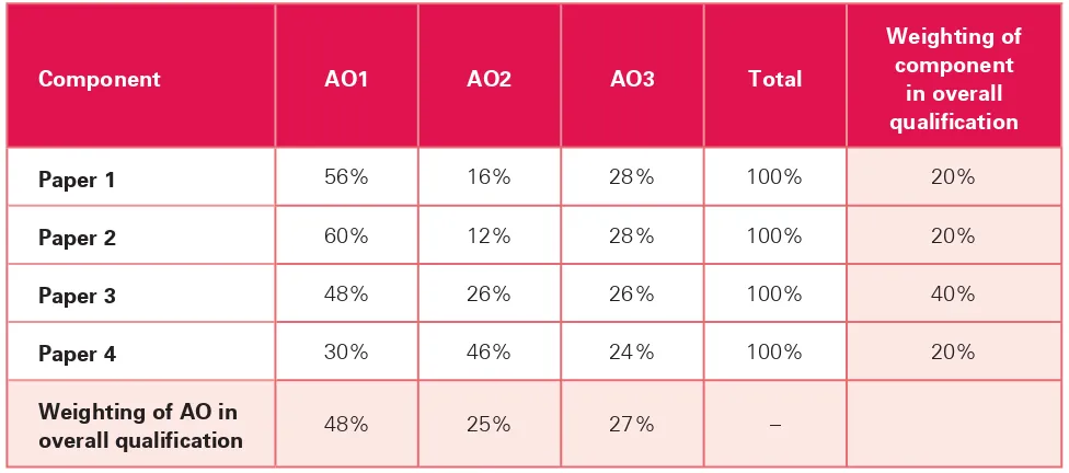
[image:9.595.54.542.205.421.2]The approximate weightings allocated to each of the assessment objectives are summarised below. The
table shows the assessment objectives (AO) as a percentage of each component and as a percentage of the
overall Cambridge Pre-U Geography qualification.
Component
AO1
AO2
AO3
Total
Weighting of
component
in overall
qualification
Paper 1
56%
16%
28%
100%
20%
Paper 2
60%
12%
28%
100%
20%
Paper 3
48%
26%
26%
100%
40%
Paper 4
30%
46%
24%
100%
20%
Weighting of AO in
Grading and reporting
Cambridge International Level 3 Pre-U Certificates (Principal Subjects and Short Courses) are qualifications
in their own right. Each individual Principal Subject and Short Course is graded separately on a scale of nine
grades: Distinction 1, Distinction 2, Distinction 3, Merit 1, Merit 2, Merit 3, Pass 1, Pass 2 and Pass 3.
Grading Cambridge Pre-U Principal
Subjects and Short Courses
Distinction
1
2
3
Merit
1
2
3
Pass
1
2
Grade descriptions
The following grade descriptions indicate the level of attainment characteristic of the middle of the given
grade band. They give a general indication of the required standard at each specified grade. The descriptions
should be interpreted in relation to the content outlined in the syllabus; they are not designed to define that
content.
The grade awarded will depend in practice upon the extent to which the candidate has met the assessment
objectives overall. Shortcomings in some aspects of the examination may be balanced by better
performance in others.
Distinction (D2)
• Candidates demonstrate wide-ranging, detailed and accurate knowledge of places and environments
identified in the syllabus.
• Candidates have clear and critical understanding of how a comprehensive range of geographical
concepts, principles and processes apply to geographical issues, environments and global concerns.
• Candidates apply this knowledge and understanding effectively to analyse familiar and unfamiliar
contexts.
• Candidates support their responses with the use of detailed examples and case studies at different
scales, where appropriate.
• Candidates show an ability to identify and investigate appropriate questions clearly and perceptively.
• Candidates interpret maps, photographs, graphs, diagrams and tables proficiently, demonstrating skills
of analysis and synthesis.
• Written communication is clear, concise and organised effectively, using geographical terminology
accurately.
• Candidates show clear understanding of the often complex links between factors, processes and
outcomes.
• Candidates recognise that outcomes may vary spatially, temporally and between different groups of
people.
• Candidates evaluate and assess strategies to address issues and global concerns with insight, making
well-reasoned judgements based on evidence to present their conclusions.
Merit (M2)
• Candidates demonstrate a sound and substantial knowledge of places and environments identified in
the syllabus.
• Candidates have a clear understanding of how a range of geographical concepts, principles and
processes apply to geographical issues, environments and global concerns.
• Candidates apply this knowledge and understanding soundly to familiar and unfamiliar contexts.
• Candidates support their responses with relevant examples and case studies, some at different scales.
• Candidates show an ability to identify and investigate appropriate questions.
• Candidates can interpret maps, photographs, graphs, diagrams and tables competently.
• Written communication is clear and organised and uses geographical terminology appropriately.
• Candidates show understanding of many of the often complex links between factors, processes and
outcomes and recognise the diversity of possible outcomes.
Pass (P2)
• Candidates demonstrate some knowledge of places and environments identified in the syllabus.
• Candidates show some understanding of how a number of geographical concepts, principles and
processes apply to geographical issues, environments and global concerns.
• Candidates show some ability to apply this knowledge and understanding to familiar and unfamiliar
contexts.
• Candidates support their responses with some relevant examples and case studies which may lack
detail and an appreciation of scale.
• Candidates show some ability to identify and investigate questions.
• Candidates offer limited interpretation of maps, photographs, graphs, diagrams and tables.
• Written communication is mostly clear but may lack organisation.
• There is largely accurate use of geographical terminology with some generality of expression.
• Candidates show some understanding of the links between factors, processes and outcomes.
• Candidates are able to evaluate and assess strategies to address issues and global concerns but these
assessments may lack depth or not cover all the main relevant areas.
Description of components
Papers 1 and 2 are examined consecutively with a short break between the two.
Paper 1 Global Environments
Written paper, 1 hour 30 minutes, 50 marks
Paper 1 is divided into two sections, Section A and Section B. Candidates answer questions from one topic
in Section A and questions from one topic in Section B. Each topic consists of a two-part structured data
response question and two extended writing questions. Within each chosen topic candidates answer the
structured questions and choose one of the extended writing questions.
Section A
Hot arid and semi-arid environments
Glacial and periglacial environments
Coastal environments
Section B
Tropical environments
Temperate environments
The atmospheric environment
Paper 1 focuses on different types of physical environment, with an emphasis upon the interrelationships
between physical and human components of those environments. The study of these environments aims to
develop knowledge and understanding of:
• the relevant physical processes and factors operating in the environment
• how these physical processes and factors influence human activity in the environment
• how human activity influences the environment
• how the environment might be managed sustainably.
In all options on Paper 1, candidates will be expected to be able to use examples and case studies
at different scales from a range of places. Where relevant, such exemplar material should include
material from countries and areas at different levels of development.
Through studying these options, candidates will be expected to have used and developed the following
geographical skills:
• An ability to interpret geographical information using a variety of techniques involving maps, tables,
graphs and diagrams, and the use of information technology, where relevant, including Geographical
Information Systems (GIS), in order to identify, describe and explain geographical patterns.
• An ability to interpret Survey and other published maps at different scales, and to link them to
photographs, aerial photographs and satellite images to identify, describe and explain geographical
patterns.
• An ability to evaluate information and arguments and produce reasoned conclusions based upon the
evidence assembled.
Paper 2 Global Themes
Written paper, 1 hour 30 minutes, 50 marks
Paper 2 is divided into six topics, arranged in two sections. Candidates must answer one question in each of
Section A and Section B.
Section A
Migration and urban change
Trade, debt and aid
People, place and conflicts
Section B
Energy and mineral resources
The provision of food
Tourism spaces
Paper 2 focuses on selected aspects of human activity from a geographical viewpoint. The study of these
global concerns aims to develop knowledge and understanding of:
• the nature of the issues at different scales associated with these global themes
• how these issues relate to both physical and human environments
• how and why these issues have developed
• how these aspects of human activity might be managed more sustainably.
In all options on Paper 2, candidates will be expected to be able to use examples and case studies
at different scales from a range of places. Where relevant, such exemplar material should include
material from countries and areas at different levels of development.
Through studying these options, candidates will be expected to have used and developed the following
geographical skills:
• An ability to interpret geographical information using a variety of techniques involving maps, tables,
graphs and diagrams, and the use of information technology, where relevant, including Geographical
Information Systems (GIS), in order to identify, describe and explain geographical patterns.
• An ability to interpret Survey and other published maps at different scales, and to link them to
photographs, aerial photographs and satellite images to identify, describe and explain geographical
patterns.
• An ability to evaluate information and arguments and produce reasoned conclusions based upon the
evidence assembled.
Paper 3 Geographical Issues
Written paper, 2 hours 45 minutes, 105 marks
Paper 3 is divided into three sections. Candidates answer five questions. Candidates must answer two
questions from Section A, two questions from Section B and one question from Section C.
Section A
Tectonic hazards
Meteorological hazards
Hydrological hazards
Section B
Crime issues
Health issues
Spatial inequality and poverty issues
For sections A and B each topic consists of a four-part structured question. Candidates choose two topics
from each of section A and B.
Section C consists of three general questions, from which candidates choose one. This section gives an
opportunity for extended writing based on more than one of the issues studied.
The focus of this paper is the study of a number of geographical issues that pose a threat to human
well-being, activity and life. These issues should be studied in the context of their causes, impacts and
management, with an emphasis upon how physical and human environments influence the impact of these
issues and how they can be managed to reduce that impact.
Candidates will be expected to have studied at least one example of a location where several of these
issues are present.
In all options on Paper 3, candidates will be expected to be able to use examples and case studies
at different scales from a range of places. Where relevant, such exemplar material should include
material from countries and areas at different levels of development.
Through studying these issues, candidates will be expected to have used and developed the following
geographical skills:
• An ability to interpret geographical information using a variety of techniques involving maps, tables,
graphs and diagrams, and the use of information technology including, where relevant, Geographical
Information Systems (GIS), in order to identify, describe and explain geographical patterns.
• An ability to interpret Survey and other published maps at different scales, and to link them to
photographs, aerial photographs and satellite images to identify, describe and explain geographical
patterns.
• An ability to evaluate information and arguments and produce reasoned conclusions based upon the
evidence assembled.
Paper 4 Research Topic
Written paper, 1 hour 30 minutes, 50 marks
Paper 4 is divided into three topics. Candidates answer structured questions from one topic. Each topic
consists of two structured data response questions and two extended writing questions. Candidates answer
the structured questions in their chosen topic and choose one of the extended writing questions.
For examination in 2016 the topics are:
•
Small-scale ecosystems
•
Managing rural environments
•
Fluvial geomorphology
For examination in 2017 the topics are:
•
Retail patterns
•
Managing rural environments
•
Fluvial geomorphology
For examination in 2018 the topics are:
•
Retail patterns
•
Deprivation
•
Fluvial geomorphology
In preparation for this written paper, candidates must carry out a research investigation involving fieldwork.
Candidates will also be expected to carry out secondary research, both in support of their individual research
investigation and in making a wider study of their chosen topic.
Research investigation
With guidance from the teacher, candidates identify a suitable geographical question or hypothesis from
within one of the prescribed topics for their individual research investigations. Candidates should devise
their own individual questions or hypotheses and follow through the investigation independently but it is
acceptable for fieldwork to be carried out as a group. The investigation should reflect the following stages in
research:
1 Identify a suitable geographical question or hypothesis for investigation
Questions/hypotheses
should:
• be at a suitable scale
• provide opportunity for research
• be clearly defined, with named location(s)
• be based upon wider geographical theories, ideas or concepts.
2 Develop a plan for conducting the investigation
Plans
should:
• establish the data needed to examine the question/hypothesis posed
• establish appropriate strategies and methods for collecting the necessary data (including sampling
where appropriate)
• understand limitations imposed by resources
• appreciate and minimise potential risks in undertaking research.
3 Collect and record data appropriate to the geographical question or hypothesis
Collection and recording of data should:
• make use of primary and secondary data as appropriate to the question/hypothesis posed
• consider issues of accuracy and reliability in relation to the data being collected.
4 Present the data collected in appropriate forms
Presentation
should:
• use appropriate techniques to present the data collected
• be appropriately organised
• be relevant to the question/hypothesis posed.
5 Analyse and interpret the data
Analysis and interpretation should:
• describe the findings of the data presentation
• analyse the data using statistical techniques if appropriate
• interpret the results in relation to the original question/hypothesis posed.
6 Present a summary of the findings and an evaluation of the investigation
Summary and evaluation should:
• draw upon evidence presented in previous sections to provide a clear conclusion, which relates back
specifically to the original question/hypothesis posed
• evaluate the extent to which the study supports or otherwise the general geographical theories,
ideas or concepts being studied
Research guidance
Since Paper 4 relates to research topics, exhaustive syllabus content is not provided, allowing candidates
to follow their own particular interests within the prescribed topic and giving a range of opportunities for
fieldwork. However, guidance is published on the Cambridge website in advance to indicate possible ideas
for investigation, and possible themes for wider study.
Examination format
The examination is set in three sections, one on each of the research topics published in advance.
Candidates answer three questions, in the section for their chosen research topic:
• A compulsory structured data response question, on the chosen research topic but in an unfamiliar
context.
• One question, divided into two parts, based on the wider research topic.
• One question from a choice of two, based on the individual research investigation.
Candidates are not permitted to take their research investigation into the examination.
In studying their chosen research topic, candidates will be expected to have used and developed the
following geographical skills:
• An ability to carry out research using both primary and secondary data collection.
• An ability to interpret geographical information using a variety of techniques involving maps, tables,
graphs and diagrams and the use of information technology including, where relevant, Geographical
Information Systems (GIS), in order to identify, describe and explain geographical patterns.
• An ability to interpret Survey and other published maps at different scales, and to link them to
photographs, aerial photographs and satellite images to identify, describe and explain geographical
patterns.
• An ability to evaluate information and arguments and produce reasoned conclusions based upon the
evidence assembled.
Core geographical skills
In all four papers, candidates will be expected to be competent in the following core geographical skills.
Use and interpretation of maps:
• Candidates should be familiar with Ordnance Survey maps at 1:50 000 and 1:25 000, but should also be
able to react to and interpret Survey maps from other countries, provided with appropriate keys.
• Candidates should be able to select, draw and interpret a variety of thematic maps, including land-use
and geology maps, distribution maps (choropleth, isoline, dot, flow-line, desire line).
Use and interpretation of graphic techniques:
• Candidates should be able to select, use and interpret a variety of forms of graphical presentation,
including pie charts, bar charts, histograms, scatter graphs, dispersion diagrams, triangular graphs.
Use and interpretation of photographic resources:
Use and interpretation of sketch maps and diagrams:
• Candidates should be able to draw, annotate and interpret various forms of sketch map and diagram,
including flow diagrams.
Use of information from secondary sources:
• Candidates should be able to access, interpret and draw relevant information from secondary sources,
including textbooks, articles, censuses, the internet and Geographical Information Systems (GIS).
Use of written skills:
• Candidates should be able to contrast and compare resources, places and ideas, and be able to evaluate
ideas and strategies.
Syllabus content
Paper 1 Global Environments
Section A – Hot arid and semi-arid environments
Main themes
Specified content
Definitions, classification and distribution
The meaning of aridity and an aridity index. The current global distribution of hot arid and semi-arid areas.
The concept of dryland environments.
Definition of desertification and the global distribution of desertified and desertifying areas. Past changes in the extent of aridity relating to climatic change: tertiary and quaternary deserts and pluvials.
Controlling factors: Climate and the hydrological cycle
The causes of aridity:
• Pressure and wind systems: high pressure and subsidence; subtropical areas • Ocean currents: continentality; rain shadow effect
• Drought periodicity
The characteristics of typical desert climates: • Temperature ranges and extremes
• Rainfall totals and reliability (including extreme rainfall events) • Evapotranspiration
The hydrological cycle and water balance in hot arid and semi-arid environments: • Desert hydrological system and regime
• Episodic rainfall, flash floods
The role of climate in influencing natural sources of water in hot arid and semi-arid environments.
Natural sources of water in hot arid and semi-arid environments: • Aquifers
• Coastal mist and fog • Dew
Processes and landforms in hot arid and semi-arid environments
Weathering processes:
• Thermal fracture, exfoliation, frost shattering, wetting and drying, chemical weathering, salt weathering
Processes of erosion:
• By wind (abrasion, deflation) • By water (sheet runoff, abrasion) Processes of transportation:
Main themes
Specified content
Landforms and landscapes of the past and present
The variety of hot arid and semi-arid landscapes:
• Mountain deserts, sand deserts, shield deserts, stony deserts The formation of erosional landforms:
• By wind (deflation hollows, ventifacts, rock pedestals and zeugen, yardangs) • By water (wadis, arroyos, canyons, mesas, buttes, inselbergs, surface crusts,
pediments)
The formation of depositional and transportational landforms:
• By wind (dunes: including barchans/crescent, transverse, seifs, longitudinal/linear, star and draa)
• By water (alluvial fans, bajadas, playas, washes, salt flats) Human activity and its
impact on hot arid and semi-arid environments
Human interaction with hot arid and semi-arid environments:
• Traditional lifestyle of societies which could include Tuareg, Masai and Fulani • Impact of change in the last 50 years on these societies
Opportunities and constraints for human activity. The contribution of humans to desertification including:
• Overgrazing, over-cultivation and tree or shrub vegetation clearance • Resource use: water collection and storage, irrigation, mineral extraction
• Secondary, tertiary and quaternary sectors: manufacturing, tourism, scientific research, space and defence industries
• Urban development • Climate change
The consequences, including:
• Rates of soil degradation and erosion (including salinisation)
• Feedback mechanisms: albedo change through denudation, atmospheric dust • People: migration, traditional response and preparation, famine and drought Management Management strategies in hot arid and semi-arid environments illustrated by:
• The issues associated with settlement, transport and infrastructural development • The issues associated with economic development, including oil extraction and water
supply
Paper 1 Global Environments
Section A – Glacial and periglacial environments
Main themes
Specified content
Definitions, classification and distribution
The meaning of glacial and periglacial environments.
Recognition of the range of glacial environments (including relict glacial landscapes, ice cap environments, upland and lowland glacial environments).
The present distribution of periglacial and glacial environments. The past distribution of periglacial and glacial environments:
• Climatic change through geological time with particular emphasis on the Quaternary Ice Age (glacial and interglacial cycles and stadial periods)
Causes of distribution and glacial movement
The possible causes of global climate change during the Quaternary. The process of glacial advance and movement:
• Internal deformation, basal sliding and subglacial deformation, surge conditions, compressional/extensional flow
Glacial processes and landforms
The processes of weathering (frost shattering), erosion (abrasion, fracturing, plucking, dilatation, regelation), transportation and deposition.
Glacial budget and the mass balance: • Snowfields, névé and firn
• Accumulation and ablation zones
• The states of net accumulation and net ablation The formation of erosional landforms:
• Corries or cirques, arêtes, pyramidal peaks, truncated spurs, U-shaped valleys, Alp benches, glacial troughs, rock basins, ribbon lakes, hanging valleys, roches moutonnées, crags and tails, striations
The transportation of moraine (supraglacially, englacially and subglacially). The formation of glacially deposited landforms:
• Till deposits, erratics, moraines, drumlins
The formation of fluvio-glacial landforms of deposition:
• Outwash plains, varves, kames and kame terraces, eskers, kettles, braided streams Periglacial processes
and landforms
Permafrost, the active layer and their importance in the formation of specific periglacial landforms.
Ground ice formation and landforms associated with it:
• Involutions, ice lenses, ice wedge polygons, patterned ground, pingos, thermokarst landscape
Landforms associated with frost weathering and mass movement:
• Blockfields, tors, scree slopes, gelifluction lobes, head and coombe deposits, asymmetrical valleys
Human activity and its impact on glacial and periglacial environments
Human interaction with glacial and periglacial environments:
• Traditional lifestyle of societies which could include Inuit and Saami • Impact of change in the last 50 years on these societies
The opportunities and constraints of glacial and periglacial environments:
• Tourism, water supply, energy, agriculture, mining and quarrying and settlement, infrastructural developments
• The significance of the active layer • Military, strategic and geopolitical factors
Main themes
Specified content
Management Management in glacial and periglacial environments. Issues associated with:
• Environmental fragility • Scenic value and tourism
• Settlement, transport and infrastructural development • Economic development, including oil extraction • Disputed territories
The role of sustainable development: • Conservation
Paper 1 Global Environments
Section A – Coastal environments
Main themes
Specified content
Factors influencing coastal environments
Definitions of coastal environments.
The range of factors which can influence coastal environments. Temporal variations:
• Diurnal: tides
• Long term: isostatic and eustatic influences on sea level Wind-generated waves:
• Formation, structure and energy
• The shoaling translation; swash, backwash, refraction, reflection • Classification of different wave types: spilling, plunging, surging
Currents: wave induced, shore normal, long-shore, rip cell circulation, offshore and onshore currents.
Temperature and salinity variation within oceans: the North Atlantic Ocean Temperature Conveyor.
Processes of marine erosion, transport and deposition:
• Hydraulic action, wave quarrying, corrasion, attrition, corrosion or solution • Longshore drift, sediment transport, sorting and deposition, sediment cells Sub-aerial processes:
• Weathering (chemical, wetting and drying, biological, frost shattering) • Mass movements (falls, slides, slumps, flows)
Structure, lithology and coastal morphology:
• Variation in resistance of coastlines to marine processes, differential erosion • Variation of supply and characteristics of sediment in the marine environment
Human influence on coastal processes, e.g. dredging and exposure, construction of hard defences, reclamation, land use change.
Landforms produced in coastal environments
Coastal landforms as associated with different coastal environments:
• Macrotidal environment landforms (range above 4 metres): mudflats, saltmarshes, sand dunes
• Microtidal environment landforms (range under 2 metres): spits, barrier islands Wave-induced landforms independent of the tidal environment:
• Beaches in profile and plan • Cliffs and shore platforms
Concordant/Pacific and discordant/Atlantic coastlines. Features associated with relative sea level change:
• Emergent and submergent coastlines: rias, fjords, estuaries, raised beaches, relict cliff lines
Ecosystems produced in coastal environments
The formation and development of different coastal ecosystems produced within a range of coastal environments:
• Psammoseres: coastal sand dunes
Main themes
Specified content
Human activity and its impact on coastal environments
The opportunities for and constraints on human activity including: • Resource exploitation in relation to fishing
• Manufacturing and energy industries • The tertiary sector, including recreation • Settlement and port development
The impacts of various economic developments on the coastal environment including: • Coastal flooding
• Rapid coastal erosion
• Degradation of marine ecosystems
Management Management strategies in coastal environments. Contrasting approaches:
• Non-intervention
Coastal protection – soft engineering vs hard engineering
• Soft engineering: beach nourishment, sand dune stabilisation and vegetation
• Hard engineering: sea walls, revetments, rip-rap, gabions, breakwaters, groynes, jetties, floodgates, tidal barriers
Paper 1 Global Environments
Section B – Tropical environments
Main themes
Specified content
Definitions, classification and distribution
The focus of this topic is on the tropical rainforest but other environments should be considered by way of an introduction and as an appreciation of the tropical environment as a whole.
Different tropical environments and their location today:
• Tropical lowland evergreen rainforest, tropical semi-evergreen rainforest, the montane rainforest, freshwater swamp forest; tropical savanna (tree, bush, scrub)
Tropical climates Factors affecting tropical climates and their impact on the distribution of tropical environments:
• Atmospheric circulation in the tropics – related to the Hadley Cell, the equatorial trough and the inter-tropical convergence zone (ITCZ)
• The influence of relief on tropical mountain climates
Patterns of precipitation and temperature in different tropical environments. The tropical rainforest
ecosystem
The abiotic environment:
• Tropical rainfall, tropical storms • Plant nutrients and nutrient cycling
• The structure and formation of tropical soils The biotic environment:
• Biological diversity and theories explaining it
• Forest structure (vertical stratification, shade tolerance and altitudinal changes) • Plant life and the factors influencing it
• Animal life of the forest (richness and diversity, modes of coexistence, carrying capacity of the forest) and adaptations made to suit tropical environments
• The interconnections between plants and animals (pollination, dispersal, food webs) Human activity and
its impact on tropical rainforests
Human interaction with tropical rainforest:
• Tribal communities, hunter-gatherers and sustainable interaction • Shifting cultivation
• Modernisation and change and the impact on tribal communities Unsustainable use of tropical rainforest:
• Rates of disappearance
• Logging and the timber trade, plantations and intensified tropical agriculture, animal production and utilisation (including ranching), construction (including dams, infrastructure), mineral extraction
The impact of unsustainable development on natural cycles and its implications at different scales for people:
• Soil erosion and leaching, changes to hydrology, desertification, species loss and extinction, climate change, impacts on society
Management Management for sustainability:
• International, governmental and non-governmental organisations’ (NGOs’) responses • Strategies for sustainability at regional and national scales
• Conservation schemes • Ecotourism
• Selective logging and timber management
Paper 1 Global Environments
Section B – Temperate environments
Main themes
Specified content
Definitions, classification and distribution
Definition of temperate environments.
The range of temperate environments including: • the temperate deciduous forest (TDF) biome • the northern coniferous forest biome (taiga) • temperate grassland biomes (prairies and steppes) • heathland and moorland
The current global distribution of temperate environments and their main associated zonal soils: brown earths, podsols and chernozems.
Temperate climates Factors affecting the climate:
• Atmospheric circulation in mid-latitudes – Ferrel cells, prevailing westerlies, polar front and jet streams
• Continentality • Relief
Precipitation and temperature in different temperate environments (Köppen classification: Df, Dw, Cf and Bsk):
• Seasonal patterns
Impact of climate on the distribution of temperate environments. Temperate ecosystem
structure and function
The structure and functioning of temperate deciduous woodland, northern coniferous forest, and temperate grasslands (prairies and steppes):
• Characteristic vegetation communities • Associated fauna
• Food chains and webs • Nutrient cycling
• Development of associated zonal soils, to include brown earths, podsols and chernozems
Main themes
Specified content
Human activity and its impact on temperate environments
The range, variety and consequences of economic uses of temperate deciduous woodland:
• Exploitation for timber • Clearance for agriculture
• Coppice and pollard management • Recreation
How and why deliberate and accidental introduction of non-native species has occurred. The role of forest clearance for agriculture and its consequences in changing the natural landscape for economic exploitation:
• Removal of hedgerows
Livestock farming and the creation of plagioclimactic communities.
The reasons for and impact of human activities in changing the natural landscape: • Environmental degradation of forests due to acid deposition
• Climate change
• Recreational use of forest, heath and moorland • The role of fire
• The introduction of conifers
The role of the American Mid-West and other regions as ‘bread baskets’ in supplying world grain needs and the impact of this, such as the development of the dustbowl in the 1930s.
Management The range of responses to deforestation and other changes to vegetation, such as: • Conservation initiatives by governments, non-governmental organisations (NGOs) and
international organisations at different scales • Low-impact farming initiatives
Paper 1 Global Environments
Section B – The atmospheric environment
Main themes
Specified content
Definitions, classification and distribution
The spatial distribution of global climate zones: equatorial, semi-arid tropical, arid tropical, arid temperate, humid temperate, boreal, arctic.
Processes in the atmospheric environment
The atmospheric system: inputs, transfers, stores and outputs.
Processes in the atmospheric environment and the global energy budget:
• Vertical energy budget: inputs (solar ultra-violet radiation), transfers (direct and diffuse radiation, scattering, reflection), stores (role of ozone and other atmospheric gases, clouds, buildings/roads), outputs (terrestrial infrared radiation, convection, conduction, latent heat, reflected radiation and albedo)
• Horizontal energy budget and the redistribution of energy:
– Atmospheric energy transfers in global atmospheric circulation (tri-cellular model) – The formation, location and characteristics of high/low pressure zones
– Ocean energy transfers by warm and cold ocean currents • Spatial differences in the energy budget and reasons for them Determinants of climate:
• latitude, position relative to continents and oceans, position relative to the global circulation model, altitude, local geographical features
Short term change in the atmospheric environment and its impact on human activity
The atmospheric characteristics of the cool temperate western maritime environment, and short term changes that result in variations in weather.
Atmospheric characteristics, processes and associated weather: • Jet stream
• Air masses • Polar front • Depressions • Mid-latitude storms • Anticyclones
The impact of short term day-to-day changes and periods of persistent low or high pressure in the cool temperate western maritime environment on human activity. Opportunities for, and constraints on, human activities including:
• Agriculture
• Consumer/commercial spending patterns • Travel and transport
• Leisure and tourism • Construction industry • Water supply and flooding Management strategies including:
• Agriculture: irrigation, drainage, artificial/protected agricultural environments • Commercial spending patterns: online shopping, shared and local transport
• Travel and transport: local government contingency planning, national weather warnings and advice
• Leisure and tourism: alternative activities, insurance
• Construction industry: managing impacts of weather and seasonal suitability for building work
Main themes
Specified content
Seasonal change in the atmospheric environment and its impact on human activity
Seasonal changes that result in the atmospheric characteristics of the tropical monsoon environment.
Characteristics and processes of the tropical monsoon climate:
• The migration of the inter-tropical convergence zone (ITCZ) and changes in the trade winds
• The differential heating of land and sea • Wet and dry monsoons
The influence of areas of relief.
The impact of the tropical monsoon environment on human activity. Opportunities for, and constraints on, human activities including: • Agriculture
• Cattle herding management • Tourism
• Water supply
• Settlement and housing development
Management strategies in areas affected by the tropical monsoon climate to cope with: • Seasonal changes
• The unreliable nature of monsoons • The risk of flooding
• Short term and long term management Cyclical changes
in the atmospheric environment and their impact on human activity
El Niño and La Niña (ENSO) events.
Atmospheric processes occurring in the Pacific region during these events.
The impact of El Niño and La Niña on human activity in the Pacific region and worldwide: • Socio-cultural
• Economic • Political
The environmental impact of El Niño and La Niña.
Short term and long term management strategies associated with these events at regional, national and global levels:
• Prediction through monitoring of changes in the atmosphere–ocean environment • Preparation to minimise the impacts of the change in the atmospheric environment • Rescue and recovery through minimising the loss caused by changes in the
atmospheric environment Long term change
in the atmospheric environment and its impact on human activity
Changes to the global energy budget through the enhanced greenhouse effect and global warming:
• The range of views and attitudes regarding the existence and causes of the enhanced greenhouse effect
• The natural and human causes of the enhanced greenhouse effect The predicted impacts of global warming at different scales on: • Human activity: socio-cultural, economic
• The physical environment
Management of the enhanced greenhouse effect and the impacts of global warming: • A range of strategies at different scales
Paper 2 Global Themes
Section A – Migration and urban change
Main themes
Specified content
Definition and classification of migration, suburbanisation and counter urbanisation
Types of population movements: • Scale: local, internal, international
• Direction: rural–urban, urban–rural, urban–urban, periphery–core, core–periphery • Motivation: forced, impelled, free (voluntary)
• Spatial: step migration, migration streams and counter-streams • Temporal: daily and weekly commuting, seasonal, periodic, permanent Suburbanisation and counter urbanisation:
• Definitions: urbanisation, suburbanisation, counter urbanisation The growth of dormitory, commuter and suburbanised settlements. Patterns and causes of
migration
Examples of population movements:
• Major international migration streams, including migrations within international confederations
• Examples of intra-national migration streams
The factors influencing migration, illustrated at a variety of spatial and temporal scales: • Push/pull factors, intervening opportunities and obstacles
• Economic, socio-cultural, environmental and political influences including reference to forced migrations, asylum-seeking, refugees, internally displaced persons (IDPs) The relative importance of rural–urban migration and natural increase in urbanisation and urban growth in different countries.
Consequences and impacts
Costs and benefits to source and recipient areas and to the migrants at different scales. The impacts of international migration:
• Economic: employment/unemployment, remittances, the ‘brain drain’ and ‘brain gain’ • Social: provision of services, deprivation, social tension, family, community, distinctive
urban enclaves in recipient countries, spatial segregation of migrant groups from host populations and each other
• Political resentment and integration
• Environmental: resource pressure, congestion, housing demand The impacts of internal migration:
• Rapid urbanisation – advantages and disadvantages • Primacy and the economic dominance of urban areas
• The provision of housing amenities and services – advantages and disadvantages • The development of slums, shanty towns and other informal settlements – advantages
and disadvantages
• Strain on urban infrastructure
• Effects on source areas including any effects of rural depopulation Suburbanisation and counter urbanisation:
Main themes
Specified content
Management Managing migration flows through strategies to encourage or restrict population movement:
• International: immigration controls, ‘points/quota schemes’, international agreements, financial incentives
• Rural–urban: rural development schemes, urban planning
• Urban–rural: rural housing developments, urban regeneration and re-urbanisation Management of forced migration:
• The United Nations High Commission for Refugees (UNHCR) and its role in managing refugees/IDPs; involvement of other non-governmental organisations (NGOs)
• The international legal position of refugees and the obligations of governments Managing the impacts of internal migration flows:
Paper 2 Global Themes
Section A – Trade, debt and aid
Main themes
Specified content
Global capital transfers Global transfers of capital occur in a variety of ways including trade, foreign direct investment (FDI), remittances and aid.
Global capital transfers can create debt. Different types of debt including trade deficits. The global pattern of debt.
Patterns of world trade, their consequences and management
Patterns of world trade:
• Major importers and exporters of raw materials, commodities, manufactured products, services, hi-tech goods
• Global trade balances
Changing patterns of world trade since 1900: • Colonial and neo-colonial patterns
• The rise of newly industrialised countries (NICs) • Terms of trade
• The changing importance and nature of goods being traded Factors responsible for patterns of world trade:
• The principle of comparative advantage • Levels of economic development
• The influence of trade blocs, protectionism, the World Trade Organization (WTO) The benefits and problems of trade for exporters and importers:
• Balance of payments and trade deficits/surpluses • The significance of foreign currency
• Overdependence on primary products
• Neo-colonial control and trade as a political weapon The management of global trade:
• World Trade Organization (WTO)
• The role of Fair Trade, e.g. World Fair Trade Organization (WFTO) Patterns of foreign
direct investment (FDI), its consequences and management, including the issue of debt
The global patterns of foreign direct investment:
• Major donors and recipients of investment, outward FDI and inward FDI • Changing patterns of investment over time
Reasons for the patterns of FDI:
• The benefits for both recipient and donor
• The role of transnational corporations (TNCs) and global financial institutions such as the World Bank and the International Monetary Fund (IMF)
The impact of FDI:
• Economic growth and development • The problem of debt
Main themes
Specified content
Patterns of international aid and their
consequences
Different forms of aid: • Long term development aid • Short term relief aid • Bilateral/multilateral aid • Tied aid
The global pattern of aid:
• Major donors, major recipients and reasons aid is given to specific countries/projects • The role of international institutions, governments and non-governmental organisations
(NGOs) in giving aid
The consequences of aid for recipient countries:
• Socio-economic effects on local people, agriculture, markets • Political dependence on foreign governments and NGOs, corruption
Economic globalisation The roles of trade, FDI, remittances and aid in the globalisation of the world economy. The advantages and disadvantages of economic globalisation.
Paper 2 Global Themes
Section A – People, place and conflicts
Main themes
Specified content
Definitions and classifications
Origins and current relevance of common (metageographical) labels used to divide up the world: ‘West’, ‘East’, ‘Middle East’, ‘Far East’, ‘First World’, ‘Second World’ and ‘Third World’.
Definitions of a nation and a state (role, functions and purpose). Types of nationalism:
• Primordial (ancient ties and common ancestry of an ethnic group)
• Modernist (sustained through everyday practices, signs and symbols, e.g. monarchy, national anthem, currency, flag, stamps, passports, sport, etc.)
Types of border and political frontier: • Boundary
• Frontier
• Border/borderland Ethnicity:
• Ethnic groups • Ethnic segregation • Ethnic cleansing • Social polarisation • Ghettoisation
Types of conflict: non-violent, political activity, riots, terrorism, war and insurrection. Asylum seekers and refugees.
Patterns of conflict Scale and distribution of conflict: local, regional, national, transnational, global. Territorial disputes, including separatism.
Global distribution of refugees.
Causes of conflict Identity (nationalism, regionalism and localism): • Case study of ‘English’ nationalism:
– Englishness vs Britishness
– Reasons for the development of multicultural society in Britain; issues related to multicultural societies
– Challenges to Englishness posed by multiculturalism
– Challenges to Englishness posed by the British National Party (BNP) and English Defence League (EDL)
– Responses of ‘British’ politics, e.g. UK Independence Party (UKIP) Ethnicity, including racial and tribal, discrimination.
Culture, including separatism.
History, including colonisation, imperialism. Territory, including Scottish and Welsh devolution.
Ideology, including political (Communism vs Capitalism), religious and economic. Resources, including water, energy.
Main themes
Specified content
Consequences and impacts of conflicts and globalisation
Economic consequences: • Gain/loss of land • Gain/loss of resources • Changes in population
• Changes in productive capacity
Social consequences including alienation, migration, feminisation of labour, changes in working practices.
Environmental consequences including destruction of oil wells, draining marshes, deforestation, ‘water wars’.
Cultural consequences: reassertion of national/regional/local cultures, including language, global cultures in the media, the arts, sports, food.
Political consequences including ‘failed’ states; re-location/establishment of capital cities; civil society movements and protest (anti-capitalism, anti-globalisation, environmental); the role of the nation in a globalised world.
Recent boundary movements and their causes and consequences, e.g.
• Iraq (role of British in establishing boundaries in 1922, genesis of Kurdish, Sunni and Shia issues)
• Changes in boundaries of European states during Second World War; the creation of Eastern and Western bloc borderland; the breakup of the Soviet Union
• The breakup of Yugoslavia and Czechoslovakia
Management Managing the impacts of refugee movements: United Nations High Commission for Refugees (UNHCR), refugee camps, non-governmental organisations (NGOs). Managing governed spaces: devolved government, federal government. Contemporary governments in exile, e.g. Tibet, Chagos Islanders.
Paper 2 Global Themes
Section B – Energy and mineral resources
Main themes
Specified content
Classification Energy and mineral resources.
Metallic and non-metallic mineral resources.
Renewable and non-renewable resources, finite and infinite resources. Flow resources.
Non-renewable resources in terms of stocks and reserves.
The influence of economic and technological factors on the availability of energy and mineral resources.
The resource continuum. Energy resources:
supply and demand
Distribution patterns of supply and demand of selected energy resources, including oil and at least one renewable resource.
The variations in energy resource mix between countries in relation to development and resource availability.
Changing sources of energy over time both globally and within individual countries: • The shift from coal to oil and gas
• The growth of renewables and alternative sources of energy • Variations in the use of nuclear power
Mineral resources Distribution patterns and changes over time of supply and demand of a range of mineral resources both metallic and non-metallic.
Factors influencing these: • Price
• Geological conditions
• Levels of economic and technological development
• The role of foreign direct investment (FDI) and transnational corporations (TNCs) • The cycle of exploitation
• Product cycles The impact of resource
exploitation
The national impact of energy and mineral resource exploitation:
• Economic benefits, such as foreign exchange earnings, employment, the multiplier effect, debt payment
• Social, economic and environmental problems, such as living conditions and environmental degradation
The balance between domestic and imported energy resources:
• Attempts to increase the proportion of energy from renewable sources
• Arguments over the energy mix, including the debate over nuclear and renewable solutions
Main themes
Specified content
Management Managing energy and mineral resource exploitation at different scales:
• International commodity organisations, such as the Organization of the Petroleum Exporting Countries (OPEC)
• National resource policies, such as nationalisation, rationalisation, subsidies Managing the environmental impact of energy and mineral resource exploitation at different scales:
• International agreements and protocols, such as Brundtland, Club of Rome, international climate change conferences, Antarctic Treaty
• The application of international agreements at a national scale
• National policies, such as resource substitution, promotion of alternative energy use • Local approaches, such as the application of Agenda 21, land reclamation schemes Managing the socio-economic impact of energy and mineral resource exploitation at different scales:
• National policies, such as minimum wages, regeneration grants, inward investment, import tariffs
Paper 2 Global Themes
Section B – The provision of food
Main themes
Specified content
Classification and distribution patterns
The physical constraints on food supply. The patterns of agricultural production globally and nationally resulting from these constraints.
The concept of carrying capacity with reference to the theories of Malthus and Boserup, to Brundtland, and sustainability.
The difference between subsistence and commercial agriculture.
The location of major marine fish stocks and the reasons for their location. The location of fish farming and reasons for its location.
The supply of food in countries at higher levels of development
The modernisation of food production after 1950 and its consequences: • Agribusiness
• Increased yields to the point of overproduction • Changes in land tenure and farm size
• Significant landscape change
The ‘post-productionist’ phase of food production and its influence on food production systems and policy:
• Farm diversification schemes (food and non-food)
• The introduction of top-down stewardship schemes, e.g. milk quotas, set-aside, Environmentally Sensitive Areas (ESAs) and Nitrate Sensitive Areas (NSAs) in the UK • The growth of bottom-up approaches such as low impact techniques and organic
farming
The ‘neo-productionist’ phase of food production and its influence on food production systems and policy:
• Continued large-scale subsidies
• Continued intensification of production (e.g. mega-ranches/dairies) and resultant ethical concerns
• Increasing food insecurity
The exploitation of marine resources and the depletion of fish stocks as a result of: • The difficulties inherent in the working of fisheries policies
• The development of larger and more efficient trawlers
The growth of fish farming and its economic and environmental impacts. The supply of food in
the wider world
Changes in the means of supplying food in the wider world, with particular regard to: • The application of fertilisers, herbicides, insecticides and other pesticides
• How the Green Revolution served to increase food production in selected countries with reference to:
– The development of high yielding varieties of wheat, maize and rice – The extension of irrigation, drainage and terracing schemes – The use of machinery in place of manual or animal labour – Evidence of negative consequences
• Different approaches to land reform, including ‘land grabs’, and the benefits and drawbacks for agrarian communities of such reform
• The pressure to replace subsistence agriculture with cash crop production and the social, economic and environmental implications of the commercialisation of agriculture • The range of alternative, appropriate technology solutions to food shortages including
Main themes
Specified content
The supply of food: the globalisation of production and supply
The increasing demand for food as global population increases and the mismatch between population distribution and food availability.
The concept of food security.
Issues of food supply in the 21st century, such as:
• Ethical issues, such as exploitation of animals, organic production; vegetarianism/ veganism, religious and cultural differences in diets (and resultant health issues), exploitation of migrant labour and the introduction of genetically modified (GM) crops • Environmental issues, such as the loss of tropical forests and mangroves, the
introduction of monocultures, tropical prawn fisheries, air transport and food/fair miles, the potential impact of global climate change on food production
• Economic issues, such as Fair Trade, the pressure to replace subsistence production with commercial and the roles of transnational corporations (TNCs), e.g. food trading • Political issues, such as the roles of TNCs, non-governmental organisations (NGOs) and
Paper 2 Global Themes
Section B – Tourism spaces
Main themes
Specified content
Classification The definitions of tourism; as distinct from recreation and leisure.
Classifying tourism using a variety of criteria, including destination, activity, scale, tourist age, socio-economic group, personal characteristics, ecological impact.
Change over time The changing nature of the tourism industry from 1800 to the present day, including its changing scale and the changing demands of tourists. Reference should be made to the Butler life-cycle model.
The reasons for these long term changes in relation to:
• Social and economic changes, including paid holidays, shorter working weeks, earlier retirement, increasing affluence
• Socio-cultural values and attitudes, including tourist motivations and behaviour • Technological developments, including transport
• Logistical nature of the holiday product, such as package tourism • Political influences, including political instability
• Role of the media
The reasons for short term changes in relation to:
• Economic conditions, including the impact of recessions
• Unforeseen events, e.g. natural disasters, terrorist attacks, civil unrest Socio-cultural impacts
and management in tourism spaces
The factors influencing the level of socio-cultural impact: • Scale of tourism/number of tourists
• Size/population of the destination
• Level of interaction between tourists and local communities
• Similarity between the culture of the home and destination countries • Attitudes of tourists towards local communities
Positive socio-cultural impacts and the associated management strategies: • Community benefits through social development projects including health and
education
• Local cultural promotion and preservation
Negative socio-cultural impacts and the associated management strategies:
• Destruction of traditional local socio-cultural patterns including social demographic changes and cultural tensions between tourists and local communities
• Commodification of culture as a tourist resource
• Development of anti-social and illegal activities including crime, prostitution and sex tourism
Main themes
Specified content
Economic impacts and management in tourism spaces
Positive economic impacts and the associated management strategies: • Tourism and development through income generation and employment
• Redistribut