Guest Editorial
Special Issue on Women’s Activities in ISPRS
This issue of the ISPRS Journal of Photogram-metry and Remote Sensing is devoted to ‘‘Women’s Activities in ISPRS’’. It marks the first attempt to compile an issue of the Journal centered on research in geomatics conducted by women or by men and women colleagues and reported to the scientific community in articles whose lead author is a woman. When the idea for such an issue was proposed over a year ago, there was, admittedly and rightly so, some question about the need for such an endeavor. ‘‘Why not have an issue devoted to scientists over 6 feet tall?’’
The rationale for this special issue was to encour-age women to participate more actively in the scien-tific and professional activities of ISPRS and, more specifically, to write and submit scientific articles about their research to the ISPRS Journal and other ISPRS publications. In doing so, it was hoped that the issue would provide an opportunity for women to have their writing and their research reviewed by their peers and published in a special issue of a journal read by scientists throughout the world. The purpose of this Foreword is to present the special issue and provide a brief background on historical changes in women’s activities within ISPRS. It is acknowledged that this topic warrants further atten-tion, discussion and publication in an appropriate forum such as the ISPRS Highlights magazine. For example, it is envisioned that future articles in High-lights might feature reports on the status of women’s involvement in the fields of geomatics within partic-ular regions of the world or articles describing the lives and accomplishments of women pioneers in the traditionally male dominated fields of photogramme-try and surveying. In this Foreword, the intent is to:
Ž .1 briefly introduce three women who were in-Ž .
volved in ISPRS activities early on; 2 provide
some basic statistics that document the trend of women’s participation in studies and careers leading
Ž
to work in geomatics including photogrammetry, remote sensing, geographic information systems
ŽGIS , Global Positioning Systems GPS , cartogra-. Ž . . Ž .
phy and related subjects ; and 3 present summaries of the articles that will follow in this special issue on women’s activities in ISPRS.
At the risk of surely excluding individuals who worked very hard to pursue their interests and career goals in a time when very few women were encour-aged to study mathematics and science or enter the fields of engineering, photogrammetry and remote sensing — a place to begin a discussion on historical changes in women’s involvement in ISPRS might be an introduction to the lives of three women pioneers in photogrammetry. Born in 1921, Aino Savolainen from Finland may have been the first female student of the world in photogrammetry. Graduating in 1948, Mrs. Savolainen worked in a topographic mapping firm in Helsinki in the 1950s and then held a posi-tion in the Department of Photogrammetry at the Technical University of Helsinki from 1960 until her
Ž .
retirement in the late 1980s Torlegard, 1988 . She was the first female member of the ISPRS Council, serving as Treasurer for the 1976–1980 term, Chair of the Financial Commission for 1980–1984 and Secretary of Commission III for both the 1980–1984 and 1984–1988 terms. In recognition of her distin-guished services to ISPRS, Mrs. Savolainen was named an Honorary Member at the 1988 ISPRS Congress held in Kyoto, Japan. To date, she is still the only woman to have received this distinctive honor.
Professor Giovanna Togliatti from Italy followed Mrs. Savolainen as the only other woman who has
Ž
served on the ISPRS Council Konecny and Fritz,
0924-2716r99r$ - see front matterq1999 Elsevier Science B.V. All rights reserved. Ž .
.
1992 . Dr. Togliatti was Treasurer from 1984 to 1988 and Chair of the ISPRS Financial Commission from 1988 until her untimely death in 1990. She graduated with a degree in applied mathematics from New York University in 1953 and a degree in pure
Ž
mathematics in 1959 from Genoa University
Mus-.
sio, 1992; Konecny, 1992 . After obtaining her Ph.D., Dr. Togliatti taught applied statistics and then pho-togrammetry at the Milan Technical University. Over the course of her career she was very involved in the then emerging field of mapping from space. In par-ticular, Dr. Togliatti led the evaluation of the carto-graphic potential of photographs acquired by the Metric Camera on-board the first European Spacelab Mission carried by the US-Space Shuttle. In the words of Dr. Gottfried Konecny, ‘‘Giovanna’s bright and determined activities were like a fresh wind to classical approaches of photogrammetry and remote sensing. She did not mind to swim against the stream
Ž .
and succeeded in doing so.’’ Konecny, 1992 . Throughout the world, Mrs. Clarice Norton from the United States was known fondly as ‘‘Mrs. Cam-era Calibration for Fairchild’’. Born in 1910, she was initially discouraged from pursing her dream to study engineering after completing secondary school and, instead, married and helped to raise a family for 13
Ž .
years Peck, 1994 . In 1941, the U.S. Defense De-partment funded college-level training at the Institute of the Engineering Colleges of Greater New York
Žsponsored by Columbia University for much needed.
engineers to work in defense related industries. Mrs. Norton’s husband encouraged her to apply and from over 10,800 applicants, 384 men and one woman passed the entrance examination. ‘‘Being the mother of three young children and the only woman in her class presented her with challenges the men did not face,’’ wrote Lauren Peck, an associate of Mrs. Norton’s who worked with her for many years and wrote her Memorial Address in Photogrammetric
Ž .
Engineering & Remote Sensing Peck, 1994, 1998 . In this regard, Mrs. Norton remains an inspiration today for men and women who must juggle the responsibilities of their personal and professional lives.
Mrs. Norton went on after completing the engi-neering training in 1941 to work for the Fairchild Aviation Corporation, receive her B.A. degree in mathematics from New York University and then
return to Fairchild Camera and Instrument Corpora-tion in 1950 where she eventually became the techni-cal director of the Camera Calibration Laboratory and the Chief of the Quality and Reliability
Depart-Ž .
ment’s Optical Section Peck, 1994 . In 1968, after a 30-year career with Fairchild, Mrs. Norton retired. Two years later, however, she was sought out by the U.S. Air Force as one of only a few qualified people with the expertise to direct the then new Carto-graphic Camera Calibration Facility at Hills Air Force Base in Utah. Mrs. Norton accepted the position and went on to work there another 22 years until her death at the age of 82. Her interest in photogramme-try included participation in the American Society
Ž .
for Photogrammetry and Remote Sensing ASPRS and in ISPRS where she served as Secretary of Commission I from 1968 to 1972. She also actively contributed to working group meetings and technical programs held at ISPRS Congresses and Mid-Term
Ž . Ž .
Symposia in London 1960 , Portugal 1964 ,
Lon-Ž . Ž . Ž .
don 1966 , Switzerland 1968 , Canada 1972 ,
Fin-Ž . Ž . Ž .
land 1976 , Japan 1978 , Germany 1980 and
Ž .
Australia 1982 . Although her health prevented her from attending the XV Congress held in Brazil in 1984, she was able to travel to Kyoto, Japan to attend the 1988 XVI Congress. At 81 years of age, she prepared to attend the 1992 XVII Congress in Washington, DC, but in the end had to cancel her plans due to ill health.
The lives of these women are presented here for the education and inspiration of all who have strug-gled to pursue personal goals while faced with obsta-cles or discouraged from doing so. As young women in the 1940s and 1950s, these three women had no role models to follow and often found themselves the only women in their classrooms and work places. Although it is fortunate that this is not usually the case today, there remain considerable gender differ-ences in educational experidiffer-ences — both in attitude and achievement, in the number of higher degrees earned and in placementrretention within the labor force.
It is well-documented in both developed and de-veloping countries that young girls and boys tend to perform equally well in mathematics and science
Ž
courses up to the age of approximately 10 Keeves
.
courses, however, drops significantly during
post-Ž
secondary school Office of Technology Assessment,
.
1988; Hanson, 1996 . Surveys of 17-year-olds show there are gender differences favoring males in sci-ence proficiency test scores and young men are more than three times as likely to pursue a career in
Ž
science, math or engineering National Center for
.
Educational Statistics, 1994 .
Although women have earned the majority of bachelor’s degrees in all fields combined since 1982, they earn only 44% of the undergraduate science
Ž
degrees and 15% of the engineering degrees
Han-.
son, 1996; National Science Foundation, 1994 . This trend is similar for higher degrees as well with women receiving 45% of the master’s degrees in science and 29% of the doctorates. Considering engi-neering alone, the percentages drop to 14% of the master’s degrees and only 9% of the doctoral de-grees. In addition, at all levels of post-secondary education, women are more likely to drop out of science and engineering programs than are men
ŽHanson, 1996 ..
Since the 1970s, there has been a growing aware-ness of gender issues in science and mathematics.
Ž .
Table 1
Percentage of women active in mapping and surveying in all
Ž
world regions, listed by educational level adapted from
Branden-.
berger, 1997
Educational Level 1980 1990 Projected to 2000
Professional Level 3.6% 4.0% 7.0%
ŽUniversity graduate
.
degree required
Middle Educational 5.2% 22.9% 23.8%
Ž .
Level Technician
Auxilary and 24.0% 35.3% 36.5%
Administrative Level
Equity programs have emerged that are designed to improve girls’ and young women’s participation and
Ž
success in mathematics e.g., the EQUALS project in
. Ž
California, USA and science e.g., the McClintock Collective in Victoria, Australia named in honor of Dr. Barbara McClintock’s 1983 Nobel prize for
. Ž
medicine and physiology Kreinberg and Lewis,
.
1996 . Evidence is presented by Keeves and Kotte
Ž1996 demonstrating significant improvement in the.
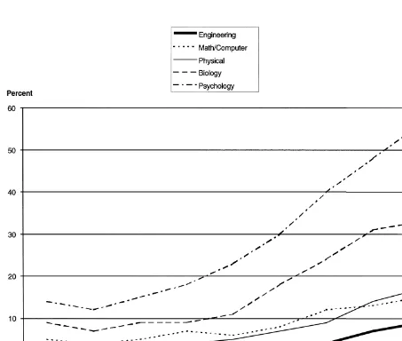
science achievement of girls relative to boys over the period of 1970–1984 suggesting societal and educa-tional policies introduced since the 1970s could be having the desired effect. Improvement in closing the gender gap in recent years is evident in Fig. 1 depicting the percent of Ph.D.s earned by women in the various fields of science and engineering
be-Ž .
tween 1950 and 1990 Malcom, 1993 .
An interesting study on the status of women employed in the mapping and surveying world was
Ž .
conducted by Brandenberger 1997 . Sponsored by the United Nations and the Pan American Institute of
Ž .
Geography and History PAUGH , information was collected from 67 professional surveying and map-ping organizations throughout the world to determine the current situation on the employment of women in the fields of geodetic and terrestrial surveying, pho-togrammetry, photointerpretation, remote sensing and
Ž
cartography collectively referred to as mapping and
.
surveying . Results indicated that in 1990, women held approximately 35% of the auxiliary and
admin-Ž
istrative positions, 23% of the middle positions i.e.,
.
technicians and only 4% of the professional level
Ž
positions requiring university graduate degrees
Ta-.
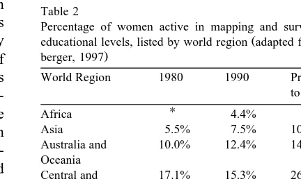
ble 1 . When data are combined for all educational levels, regional differences in the percentages of women active in mapping and surveying are evident, as are especially low percentages in areas such as
Ž .
Africa and Asia Table 2 . It is encouraging to note that in nearly all regions of the world there is evidence of improvement in the activity of women in mapping and surveying as projected by
Branden-Ž . Ž .
berger 1997 to the year 2000 Tables 1 and 2 . Although no statistical data have been compiled yet on the scientific publications of female authors in journals, conference proceedings, etc., it is clear that female scientists are getting increasingly involved in the fields of geomatics, and especially in GIS and remote sensing, with the respective scientific output. Likewise, their involvement in the professional
activ-Ž
ities of ISPRS is stronger there are 13 female ISPRS officers for the period 1996–2000 compared to 6 for
.
1992–1996 .
The articles that follow in this special issue of the ISPRS Journal reflect the growing contributions of women scientists from many parts of the world to the various fields of geomatics. In the first article, Metternicht describes a methodology for determining the likelihood of land use changes detected from remotely sensed image data. Using fuzzy modelling and the characteristics of a change image derived from two preclassified images, a new image depict-ing the likelihood of change is created. Visualization
Table 2
Percentage of women active in mapping and surveying for all
Ž
educational levels, listed by world region adapted from
Branden-.
berger, 1997
World Region 1980 1990 Projected
to 2000
U U
Africa 4.4%
Asia 5.5% 7.5% 10.8%
Australia and 10.0% 12.4% 14.9%
Oceania
Central and 17.1% 15.3% 26.8%
South America
Europe 15.9% 21.5% 27.5%
North America 14.4% 16.5% 20.0%
Ž
Total Sum and 13.1% 14.8% 20.8%
.
weighted means U
of areas undergoing changes can then be incorpo-rated into a decision support system for identifying critical regions requiring map and database revision. Kubler and Voisard present a multimedia inter-
¨
face for geologic hypermaps, defined as digital maps connected by hyperlinks to background information such as text, scanned images, ground truth informa-tion, etc. A prototype known as GeoHyp was created in the GIS environment of ArcView and tools were developed to display various types of geologic maps, access the underlying background database and per-form analysis functions designed to meet specific geologic requirements.
The suitability of laser data for digital terrain
Ž .
model DTM generation is discussed in the context of a case study in road planning and design in The Netherlands by Pereira and Janssen. Laser range data acquired from a helicopter were evaluated for accu-racy and level of derived information. Results indi-cate that although high density laser measurements of four points per square metre do allow accurate reconstruction of terrain relief for road planning, they lack semantic information needed for labeling objects. The combination of laser data with existing information stored in GIS databases is therefore con-sidered.
Panigraphy et al., evaluated RADARSAT
syn-Ž .
thetic aperture radar SAR image data for use in discriminating rice and potato crops in India. C-band data of HH polarization acquired on four dates in 1997 were used to study the temporal backscatter characteristics of these crops in relation to their growth stages. Results show backscatter was lowest during early puddling of rice fields and increased as the crops matured. Crop areas of rice could be estimated within 20–30 days of transplanting, earlier than is possible using optical remote sensing data. The backscatter of potato crops, on the other hand, was much more variable.
The problem of content-based image retrieval from large spatial databases is addressed by Agouris et al., using queries on shape and topology. Focusing on image databases used in typical topographic applica-tions, a spatial data management system was devel-oped that enables users to provide sketches of the shape and spatial configuration of the objects that should appear in the images to be retrieved. The authors’ approach combines the design of an
inte-grated database with a feature library and provides the required matching tools. The overall retrieval scheme, individual components of the database and an example of its implementation are presented.
Neusch and Sties describe an application of the semi-empirical Dubois-model for determining soil moisture and surface roughness using airborne E-SAR data. Acquired in C-, L- and P-bands over a small watershed in southwest Germany, the radar image data were evaluated for use with the model to measure dielectric properties of the soil surface di-rectly related to the amount of soil moisture and mirrored by detectable differences in the backscat-tered signal. Surface roughness of fields was also modeled independently of soil moisture. Compar-isons with moisture and roughness measured in the field revealed that best results are obtained in bare and sparsely vegetated areas. The measured C-band values show better agreement with the expected model values than the L-band.
Airborne remote sensing applications are increas-ingly becoming dependent upon Global Positioning
Ž .
System GPS technology. Although positioning ac-curacies are largely adequate for current applications, projected auroral substorm activity is expected to degrade positioning accuracies around the year 2000. Skone and Cannon estimate this error based on the spatial decorrelation of ionospheric range delay that occurred during a substorm event in 1997. Positional
Ž .
errors both vertical and horizontal in the range of
Ž .
" 60 to 80 cm root mean square RMS error were found to be generated during the substorm event, representative of the activity that is anticipated dur-ing the solar maximum in 2000.
Finally, Radhadevi describes a method for pass processing of IRS-1CrD image data acquired by the
Ž .
three CCD arrays of the panchromatic PAN sensor. The data generated during a pass are adjusted to-gether as a single image by exploiting knowledge of the internal geometry and the angular relationships between the CCD arrays. The single full PAN scene
Žactually made up of nine subscenes each with a
dimension of 23.5 x 23.5 km and spatial resolution
.
of 5.8 m can then be rectified with a single ground
Ž .
when using survey-grade control for the single GCP and the check points.
In conclusion, it is hoped that this special issue on Women’s Activities in ISPRS will generate an awareness of research being conducted by teams of men and women scientists in all parts of the world and in the various fields of geomatics. Women re-searchers are encouraged to continue their work in photogrammetry, remote sensing, GIS, GPS, cartog-raphy and related subjects, to submit the results of their research to scientific journals for peer-review and publication and, most of all, to act as role models for young women considering careers in mathematics and science.
Guest Editors of the Special Issue ‘‘ Women’s Activities in ISPRS’’
Dr. Marguerite Madden
Center for Remote Sensing and Mapping Science (CRMS)
Department of Geography The UniÕersity of Georgia Athens, GA 30602, USA
E-mail: [email protected]
Dr. Monika Sester
Institute for Photogrammetry UniÕersity of Stuttgart Geschwister-Scholl-Str. 24 D-70174 Stuttgart, Germany
E-mail: [email protected]
Dr. Thelma Krug
National Institute for Space Research, INPE P. Box 515, Sao Jose dos Campos, SP Brazil, 12201-970
E-mail: [email protected]
References
Brandenberger, A.J., 1997. The status of women in the surveying
Ž .
and mapping world. Geomatica, 51 2 : 153–156.
Hanson, S.L., 1996. Lost Talent: Women in the Sciences. Temple University Press, Philadelphia, 224 pp.
Keeves, J.P. and Kotte, D., 1996. Patterns of science and achieve-ment: International comparison, In, Gender, Science and
Ž .
Mathematics, Parker, L.H., Rennie, L.J. and Fraser, J. Eds. ,
Kluwer Academic Publishers, Dordrect, The Netherlands, pp. 77–93.
Konecny, G., 1992. Mapping from space. In: Proc. of the Gio-Õanna Togliatti Memorial Tutorial on Mathematical Aspects of
Data Analysis, ISPRS Intercommission Working Group
IIIrVI, Washington, DC, pp. 1–8.
Konecny, G. and Fritz, L., 1992. Chronology of ISPRS officers. In: Proc. of the XVII ISPRS Congress, Internat. ArchiÕes of
Ž .
Photogrammetry and Remote Sensing, 24 A : 389–390.
Kreinberg, N. and Lewis, S., 1996. The politics and practice of equity: Experiences from both sides of the Pacific. In: Gender,
Science and Mathematics, Parker, L.H., Rennie, L.J. and
Ž .
Fraser, J. Eds. , Kluwer Academic Publishers, Dordrect, The Netherlands, pp. 177–202.
Malcom, S.M., 1993. Undergraduate and beyond. In: A Hand Up:
Ž .
Women Mentoring Women in Science, Fort, D.C. Ed. ,
Asso-ciation for Women in Science, Washington, DC, pp. 181–193. Mussio, L., 1992. Foreword. In: Proc. of the GioÕanna Togliatti
Memorial Tutorial on Mathematical Aspects of Data Analysis,
ISPRS Intercommission Working Group IIIrVI, Washington, DC, 83 pp.
National Center for Educational Statistics, 1994. NAEP 1992
Trends in Academic Progress. U.S. Department of the Interior,
Washington, DC.
National Science Foundation, 1994. Women, Minorities and
Per-sons with Disabilities in Science and Engineering. NSF No.
94-333HL, Washington, DC.
Office of Technology Assessment, 1988. Elementary and
Sec-ondary Education for Science and Engineering. U.S. Congress,
Washington, DC.
Peck, L., 1994. Memorial address: Clarice L. Norton.
Photogram-Ž .
metric Engineering and Remote Sensing, 60 7 : 861–864.
Peck, L., 1998. Personal communication.
Torlegard, K., 1988. Honorary members. In: Proc. of the XVI
ISPRS Congress, Internat. ArchiÕes of Photogrammetry and
Ž .