Jurnal Rekayasa Kimia dan Lingkungan Vol. 12, No.2, Hlm. 69 - 76, 2017 ISSN 1412-5064, e-ISSN 2356-1661 https://doi.org/10.23955/rkl.v12i2.8486
69
The Spatial Distribution of Bed Sediments at Krueng Cut Estuary:
The Sieve Analysis Approach
Distribusi Spasial Sedimen Dasar di Muara Krueng Cut:
Pendekatan Analisis
Sieve
Muhammad Irham1*, Ika Fibriarista1, Sugianto Sugianto2, Ichsan Setiawan3
1Program Studi Ilmu Kelautan, Fakultas Kelautan dan Perikanan, Universitas Syiah Kuala, Banda Aceh. 2Program pascasarjana Universitas Syiah Kuala, Banda Aceh
3Pusat Studi Kelautan dan Perikanan, Universitas Syiah Kuala, Banda Aceh
*corresponding e-mail : [email protected]
Received : 4 September 2017; Received in revision: 26 October 2017; Accepted : 3 December 2017
Abstract
This research studied the characteristic of bed sediment in the estuary of Krueng Cut, Banda Aceh. Analyzing the field samples from different site of stations along the channel of Krueng Cut from upstream to estuary shows different pattern and profile of deposited bed sediment. Therefore, sorting the size of sediment is important spatially because pattern of its deposition and characteristic will illustrate how distribution patterns indicate the nature of the channel. Hence, the study aims to determain the pattern of bed sediment distribution as well as its profile spatially. To implement the intended purpose, the coring method was employed by using purposive random sampling for 15 stations of taken sampling in Krueng Cut estuarial channel. The sample of sediment was proceeded by using a 2,5 cm diameter of PVC paralon at the depth of 25 cm from the bathymetry base. Samples were analyzed using wet sieve analysis method. The result informed that the dominant of bed sediment size are medium sand found around the mouth of the river, fine sand existed along the mixing area, and very fine sand occurred in the transition zone of the channel. In the region of coastal dynamic, the sediment was dominated by medium sand size, meanwhile in the area of river dominated flow, the sediment is subject to fine sand size. Thus, the fraction of very fine sand size of sediment was found in the zona of transition.
Keywords: Krueng Cut, bed sediment, sediment fraction, sieves analysis.
Abstrak
Penelitian ini mengkaji tentang studi sebaran sedimen dasar di perairan Krueng Cut, Kota Banda Aceh yang bertujuan untuk mengetahui pola sebaran dan profil sedimen dasar. Analisis sampel lapangan dari berbagai lokasi stasiun sepanjang sungai Krueng Cut dari hulu hingga muara menunjukkan pola dan profil endapan sedimen yang berbeda. Sortiran ukuran sedimen penting secara spasial karena pola deposisi dan karakteristiknya menggambarkan bagaimana pola distribusi dari sifat sungai. Oleh karena itu, penelitian ini bertujuan untuk mengetahui pola distribusi sedimen dasar serta profilnya secara spasial. Untuk mengimplementasikan tujuan tersebut, metode coring digunakan dengan menerapkan purposive random sampling untuk 15 stasiun sampling yang diambil di Krueng Cut. Sampel sedimen diambil dengan menggunakan pipa paralon PVC berdiameter 2,5 inci pada kedalaman lebih kurang 25 cm dari dasar batimetri. Sampel dianalisis dengan metode sieve analysis menggunakan ayak basah. Hasil menunjukkan bahwa bahwa ukuran sedimen yang dominan adalah pasir ukuran sedang yang ditemukan di sekitar muara sungai, pasir halus berada di sepanjang daerah pencampuran (mixing), dan pasir yang sangat halus berada di zona transisi. Pada daerah dinamika laut, sedimen didominasi oleh fraksi pasir sedang. Sedangkan daerah dinamika aliran sungai yang dominan diperoleh sedimen fraksi pasir halus. Selanjutnya sedimen fraksi pasir sangat halus diperoleh pada zona transisi.
Keywords: Krueng Cut, sedimen dasar, fraksi sedimen, analisis sieve.
1. Introduction
Sedimentation is one of the important parameters in the distribution of materials in the bottom of the waters. The deposition and distribution of sediments in the waters can
alter the depth, configuration, and
characteristics of the waters vertically and
horizontally. The pattern of sediment
distribution and its characteristics are
influenced by the action of natural
Muhammad Irham et al. / Jurnal Rekayasa Kimia dan Lingkungan Vol. 12, No. 2
70 resulting in environmental effects (Girsang and Rifardi, 2014). The natural works can be currents, waves, and tides that naturally the dynamic activities (Irham and Setiawan,
2017) require such balance in the coastal areas proceeding in erosion or deposition. While the anthropogenic activities can be in the form of construction development, fishing activities, and physical activities of
people around the water body (Irham, 2016).
The various forms of activity around the waters provide a direct impact on the waters such as sedimentation and erosion (Irham, 2016; Irham et al., 2013). Bed sediment as one of them, is a natural material that causes the deposition and erosion in the body of water either temporally or spatially (Irham, 2016). Erosion and sedimentation materials cause in the addition and reduction of sediment supply that harms a coastal area (Setiawan and Irham, 2017). The processes
of sediment additions and reductions
(erosion and deposition processes) are physically driven by flows, waves, and tides (Manengkey, 2011; Irham and Setiawan, 2017). Flows, waves, and tides are also one of the main factors causing the change of sediment type in the bottom of the waters. Nugroho and Basit (2014) explained that the current velocity affects the process of
sediment transport, sedimentation and
sediment distribution. Sediments of coarse size (gravel to course sand) may be found in a strong current areas whereas fine-grained sediments (fine sand to mud) are exist in the area of a weak flows (Irham and Setiawan, 2017).
The Krueng Cut is the downstream channel connected to the upstream waters of Krueng Aceh. Therefore, the sediment in Krueng Cut may come from Krueng Aceh as a main channel system and be input from Alue Naga beach directly related to Krueng Cut estuary. Irham (2016) and Irham and Setiawan (2017) argue that the sediment input and output in the water is because of the influence of land as a source material. Currents or flows, waves, and tides transport the material and the materials will deposit somewhere when the energy is no longer able to move the materials (Bian et al., 2013). Deposition and erosion create the negative impacts such as land expansion and land reduction (Irham et al., 2013).
Therefore, to understand how the pattern of spatial distribution and the characteristic of sediment profile occurring along the channel of Krueng Cut needs to be studied by employing spatial sieve analysis method. The purpose of this study is to know the distribution pattern of bed sediments along Krueng Cut fluvial channel. It is expected
that the results of this study can provide the information related to the distribution of bed sediments of Krueng Cut water. Local governments may also utilize the results of this study for the purpose of making decisions if development is undertaken in this area. While for the people living in this area may utilize this study as an information for the sustainability of the community economy.
2. Methodology
2.1. Material
This research used PVC tubecore with 2.5
inch diameter for sediment sampling
together with compass for sampling location and sediment bag to store the sediment before being analized in laboratorium. A set of sieve and digital weight was employed for sieving analysis.
2.2. Sampling
Muhammad Irham dkk. / Jurnal Rekayasa Kimia dan Lingkungan Vol. 12, No. 2
71
Figure 1. Map of study area and the location of sampling station along Krueng Cut channel
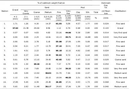
Table 1. The percentage of sediment weight (%) based on Udden-Wentworth Grain-size scale (Wentworth, 1992).
Station
% of sediment weight fraction Dominant Size
for
Clasification Gravel
Sand Mud
Very
Coarse Coarse Medium Fine Very
fine Clay Silk Total
(d) Mean size 4-2
(mm) 2-1 (mm)
1-0,5 (mm)
0,5-0,25 (mm)
0,25-0,125 (mm)
0,125-0,063 (mm)
0,063-0,038 (mm)
0,002
(mm) % (mm)
1. 1.71 1.26 4.30 14.37 62,93 9,08 4.57 1.77 100 0.024 Fine sand
2. 37.63 21.99 29.06 8.96 1.12 0.76 0.48 0.00 100 0.143 Gravel 3. 0.07 0.07 4.83 4.83 33.26 44.66 9.38 2.89 100 0.014 Very find sand
4. 0.00 0.00 2.25 10.61 10.13 39.71 20.42 16.88 100 0.010 Very find sand 5. 0.90 0.00 3.78 5.18 55.08 27.99 1.99 5.08 100 0.017 Fine sand
6. 0.94 0.21 1.77 12.73 37.16 33.51 7.20 6.47 100 0.017 Fine sand 7. 1.61 4.51 2.22 5.74 66.18 12.32 4.82 2.60 100 0.024 Fine sand
8. 1.19 0.37 2.44 28.48 50.02 9.72 1.16 6.64 100 0.023 Fine sand 9. 0.61 0.78 13.10 34.43 42.65 5.82 0.47 2.13 100 0.029 Coarse sand
10. 0.79 1.30 69.26 20.40 7.37 0.79 0.10 0.00 100 0.054 Fine sand 11. 0.55 1.10 7.69 29.85 11.54 39.33 1.88 8.06 100 0.022 Very fine sand
12. 1.49 3.09 13.92 38.84 31.79 7.46 0.94 2.47 100 0.034 Medium sand 13. 1.12 1.91 7.40 20.13 10.04 40.33 3.31 15.76 100 0.021 Very fine sand
Muhammad Irham dkk. / Jurnal Rekayasa Kimia dan Lingkungan Vol. 12, No. 2 calculation of mean size value is determined by using the Eq. 2 as:
d (2)
3. Result and Discussion
The percentage analysis of the bed
sediments weight at each sample is shown in Table 1. The sample taken in this study is consisted of 15 sample stations, 6 stations in estuarial area of the river and 9 stations in Krueng Cut water area. The percentage of sediment fraction from 15 sample stations has different mean grain size value. Generally, it was found that the distribution of bed sediment in this area is classified by fine sand with size of 0.25 mm - 0.125 mm. Sediments with the largest mean grain size were found at station 2. While the sediments with very fine grains (clays) was existed at station 4.
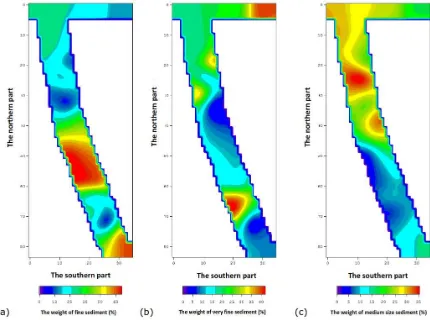
Figure 2 depicts the analysis results of the profile of bed sediment distribution in Krueng Cut water. A medium-sized sediment profile of larger than 0.25 mm is present at station 12 and 15 as shown in Figure 2a. The profile of distribution of fine sand sediments size of 0.25 mm - 0.125 mm is represented by sampling at station 1, 5, 6 , 7, 8, 9 and 14 shown in Figure 2b. While the profile of sediment distribution with size of 0.125 mm - 0.063 mm (very fine sand) as shown in Figure 2c is presented at station 3, 4, 11, and 13. Furthermore, Figure 3 shows the results of the spatial analysis of sediment distribution from the distribution of medium sand, fine sand, and very fine sand. The result is represented the dominant out come of sediment produced from sieve analysis.
Based on the results of the study (Table 1), it shows that the percentage of sediment weight in each sieve has different values. The average grain size of sedimentary fraction with the largest classification is found at sample station 2 (river dynamics zone) which is 0.143 mm size with gravel classification. While the lowest average grain size value is the sample at station 4 of 0,010
mm size, where this sample area is located in the middle of study area. This location is a region that has a weak flow due to the absence of influences of currents, tide, and downstream flow. Because of its weak flow, the sediments in this area are also classified as very fine-sized sediments. Barnard et al. (2013) states that although the dynamics of currents and waves is relatively small, however, the distributions of sediment still exist so that the dominant substrate of sediment in this area may be categorized as
muddy sediment. The relatively weak
current and small wave conditions result in the sediment being deposited in this area and the sediments are hardly to move to other areas.
Table 1 explains that the sediments at these 15 sample stations are generally classified by fine sandy sediment of 0.25 mm - 0.125 mm size as well. This classification of fine sandy sediment is caused by the current dynamics in this area which circulate small currents of both the river flow at the upper regions as well as the influence of waves and tide from the coast in the estuary. According to Dai et al. (2013), the wave is very influential on the occurrence of sediment transport at the mouth of the river. It is greater the sediment transports and settles in the estuary as of Davidson et al. (2013) found. The alternating current between the influence of the river flow and the dynamics of the sea causes the particles of fine sandy sediments to settle on site (Delpey et al., 2013). Ansar et al. (2014) stated that sediment particles with smaller sediment grain sizes will be easier to transport and take sometimes to settle. These behaviors occurred in this study and it shows that since most particles are smaller in size, they move more easily as a result of wave action
and current movement compared to
sediment particles with larger grain size as Gomes et al. (2016) found it before.
Muhammad Irham et al. / Jurnal Rekayasa Kimia dan Lingkungan Vol. 12, No. 2
73
size of sediment is getting finer toward the transition zone (Figure 3).
(a)
(b)
(c )
Muhammad Irham dkk. / Jurnal Rekayasa Kimia dan Lingkungan Vol. 12, No. 2
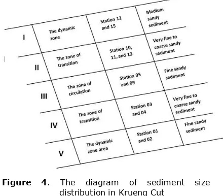
74 Figure 3 shows the zoning distribution of sediments in the study area. It shows that in areas close to the ocean where ocean currents begin to enter to the mouth of the river, the sediment in this area can be categorized as medium sandy sediment or zone of dynamic (zone I of Figure 4) due to the influence of the strong flow from the sea while the influence of flow from the river is less. The finding agrees to Warrick et al. (2013) that states the distribution of sediments can be spread toward the sea, parallel to the coastline or across the mouth of the river depending on the dominant of energy. If the spread of sediment in the direction of parallel or follow the the coastline, then the sediment found in the western estuary of the river is relatively larger than the one found in the eastern estuary of the river. Thus, the charred component (a collection of gravel or sand) is in the form of course sandy sediments which include medium-grained sediments. The
second zone is a fine sandy sediment zone (zone III of Figure 4) which is a circulation zone, the confluence area of river currents and ocean currents.
Soomere and Vika (2014). explained that muddy size sediment or very fine sandy sediment tends to be transported as a
suspended sediment with speed and
direction following the speed and direction of current. While the very fine sandy sediment zone (zone V of Figure 4) was found in the upstream area of the channel. In this area the influence of ocean dynamics has been greatly reduced while the flow from the river is sufficiently not strong, consequently the sediment is deposited in this area is very fine sandy sediment size to the silt and clay size. The farther away from the coastline, the finest size of sediment occurred. This is because of the energy that works to transport the sediment become weaker (Arisa et al., 2014).
Figure 3. The spatial distribution of fraction sediment along Krueng Cut channel
Figure 3 shows the spatial distribution of sediments in Krueng Cut with various sizes sediment fraction. Figure 3a displays the distribution of fine-grained sedimentary sand that generally occurs in the circulation area and slightly upstream site. While the spatial
distribution of very fine sand dominates the
transition zone (Figure 3b) and the
Muhammad Irham et al. / Jurnal Rekayasa Kimia dan Lingkungan Vol. 12, No. 2 sediment distribution demonstrates when the high tide condition occurred; the current from downstream moves upstream and circulates in the mid area caused by the influence of currents from the river. River currents will be dominant when in a state of ebb (low tide), with the same pattern where the river flow weaken downstream and classification in these waters was classified into 5 granular characteristics which are gravel on a scale of 4 mm - 2 mm, coarse
transportation, deposition, and distribution of sediment.
Figure 4. The diagram of sediment size distribution in Krueng Cut
Delpey et al. (2013) states that currents and waves are the main factors determining the direction and distribution of sediments that affect the different characteristics of sediments in the bottom of waters. Different particle sources cause the presence of different characteristics and distribution of
sediments. Figure 4 illustrates the
distribution of sediment based on zone of sediment size. Areas with strong current influences from both marine and river dynamics show a homogeneous sediment distribution (zones I and V). In the circulation area (zone III) shows a sediment distribution which is also homogeneous because in this region the current circulation between the sea and the river occurs. While in the mixing area where the current transition changes, the sediment distribution tends to be mixed (zones II and IV).
4. Conclusion
The research concluded that there are 3 (three) dominant sediment size fractions obtained from sediment analysis. They are medium, fine, and very fine sand size of
sediment. The largest percentage is
generally found in the size of fine sandy sediments with a size of 0.25 mm - 0.125 mm. The spatial pattern of sediment distribution in the study area depicts the zoning of sediment distribution according to the selected size. These zonations are transition zone dominated by very fine sandy
sediment, the circulation zone (the
confluence of river currents and ocean currents which is uniformly distributed the
sediment) dominated by fine sandy
sediment, and dynamic zone dominated by medium sandy sediment due to the influence of ocean currents near by the mouth of the river as well as river flows upstream.
References
Ansar, N. A., Arsyad, M., Sulistiawaty. (2014) Studi Analisis Sedimentasi Di
Sungai Pute Rammang-Rammang
Kawasan Karst Maros, Jurnal Sains dan Pendidikan Fisika, 10(3), 301- 307.
Arisa, R. R. P., Wibowo, E., Kushartono, Atmodjo, W. (2014) Sebaran Sedimen dan Kandungan Bahan Organik pada
Sedimen Dasar Perairan Pantai
Muhammad Irham et al. / Jurnal Rekayasa Kimia dan Lingkungan Vol. 12, No. 2
76 during the four seasen of 2011. Journal of Marine System, 121-122:24-35.
Dai, Z. J, Chu, A., Li, W. H., Li, J.F, and Wu, H.L. (2013) Has suspended sediment concentration near the mouth bar of the Yangtze (Changjiang) estuary been declining in recent years?, Journal of Coastal Research, 29(4), 809 – 818.
Davidson, S.K., Hartley, A.J., Weissmann, G.S., Nichols, G.J. and Scuderi, L.A. 2013. Geomorphic elements on modern
distributive fluvial systems.
Geomorphology, 180-181: 82-95.
Delpey, M.T., Ardhuin, F., Otheguy, P., Jouon, A. (2013) Effects of waves on coastal water dispersion in a small
estuarine bay, Journal Geophysic
Research, 119, 70 – 86.
Folk, R. L. (1974) Petrology of Sedimentary Rocks. Hemphill Publishing Company, Austin.
Girsang, E. J., Rifardi. (2014) Karakteristik dan Pola Sebaran Sedimen Perairan
Selat Rupat Bagian Timur, Berkala
Perikanan Terubuk, 42(1), 53 – 61. Gomes, E.R., Mulligan, R.P., Brodie, K.L.,
McNinch, J.E. (2016) Bathymetric
control on the spatial distribution of wave breaking in the surf zone of a natural beach, Coastal Engineering, 116, 180 – 194.
Irham, M. and Setiawan, I. (2017) The study of flow resulting from wave on Lhoknga
Beach, Aceh Besar, Omni-Akuatika,
13(1), 5 – 12.
Irham, M. (2016) The spatial distribution of bed sediment on fluvial system: A mini review of the Aceh meandering river,
Aceh International Journal of Science and Technology, 5(2), 82 – 87.
Irham, M., Giardino, J. R., and Guneralp, I. (2013) Two dimensional morphological dynamic modeling of a complex fluvial system: The spatial distribution of the bed sediment of the Brazos River, TX,
GSA Annual Meeting, Minnepolis.
Manengkey, H. W. K. (2011) Sebaran Ukuran Butiran Sedimen Gisik Sekitar Groin Pantai Kalasey, Jurnal Perikanan dan Kelautan Tropis, 7(3), 132 – 137.
Nugroho, S. H., Basit, A. (2014) Sebaran Sedimen Berdasarkan Analisis Ukuran Butir di Teluk Weda, Maluku Utara,
Jurnal Ilmu dan Teknologi Kelautan Tropis, 6(1), 229 – 240.
Soomere, T. and Vika, M. (2014) Simulated wave-driven sediment transport along the eastern coast of the Baltic Sea,
Journal of Marine Systems, 129, 96 – 105.
Warrick, J. A., Madej, M. A., Goni, M. A., and Wheatcroft, R. A. (2013). Trends in the suspended-sediment yields of coastal rivers of northern California, 1955-2010.
Journal of hydrology, 489:108-123.
Wentworth, C. K. (1922) A Scale of Grade and Class Terms for Clastic Sediments.