GEOGRAPHIC MODELLING AND ANALYSIS
I. INTRODUCTION
A. Background
Geographic Information System is organized within a GIS so as to optimize the convenience and efficiency with they can be used. To distinguish a GIS from other types of information system are its spatial analysis (Arronof, 1994). The GIS database is a model of the real world that can be used to mimic certain aspect of reality. An important GIS application is predicting the consequences of purpose activities.
The spatial analysis will identify area suitable for the proposed lab site and the tabular analysis will provide an estimated cost acquisition. Geographic analysis allows studying real-world processes by developing and applying models (ESRI, 1994).
Introduction and Advanced courses in Geographic Information Systems about Geographic Modeling and Analysis data sources techniques used in the planning process, with an emphasis placed on appropriate applications. We receive considerable experience in using geographic information systems technology to solve real-world problems. Modeling use GIS has the advantage, because of its capability of dynamic simulation, and repeat analysis under changing conditions.
This assignment introduce to the spatial analysis capabilities of ArcView GIS that we focus on the modeling and analysis and analysis capabilities of a GIS and working with data provide that to perform a geographic analysis application which we choice. My project is determining ideal location to build Tobacco Processing Manufacture in Lombok Island. There are several constrains for an application of interest, those are:
1. The site in agriculture area
2. Site must be within 1 km of existing road 3. Site must be beyond 500 m of existing river
4. Site must contains an area at least 50,000 meters square
The coverages should be available to support this project are lanzon, river, linriver, and road of Lombok island. The data provided in the shared directory on \\Biosvrrex01\Courses\ITM524\Assn2\Data.
B. Objective
II. GENERAL PROCEDURE
Step 1. Determining agriculture area
First requirement of the project (analysis suitable area for Tobacco Processing Manufacture), that’s site is agriculture area. To determine this land use type, we use ‘landzon’ data, which has agriculture type. The steps for determining this land use are: Start ArcView. Click Add themes to open a data.
In the Add themes dialog, chose ‘landzon’ as feature data source, then click OK (Figure 1a and 1b)
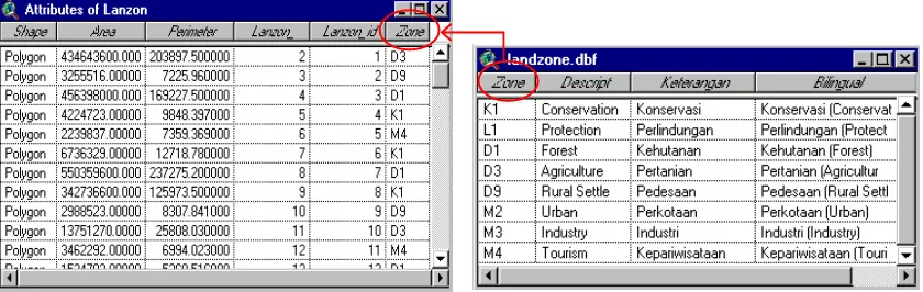
Checks the attributes of the ‘landzon’coverage. To do this, make the ‘landzon’theme active in the TOC, and click on theShowTablebutton. (Figure 2)
Open theme table
(1a) (1b)
Join item attribute table of ‘landzon’ with ‘landzone.dbf’
The attribute table of ‘landzon’ doesn’t has description or characteristic of land use (i.e. agriculture, urban, indutry, forest, etc), so to get it we have to make ‘join item’ with ‘lanzone.dbf’
o Open the attribute table of ‘landzon’ coverage and ‘landzone.dbf’
o Combine both of attribute tables by click zone field in ‘lanzone.dbf’ first, then zone
field in ‘lanzon’, and click button from toolbar menu.
Figure 1. Add theme dialog box (1a); Displaying of ‘lanzon’ feature data source
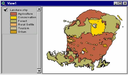
Convert the file changing to shape file as ‘Landuse.shp’ (shown as Figure 3). This file is selected to get ‘agriculture’ area by using query.
Figure 3. Displaying of ‘landuse.shp’
Query to get ‘agriculture’ site
Open theTheme menuand chooseQuery. In the query dialog, determine agriculture site, then click New Set button. The query dialog and ‘agriculture’ site is shown as Figure 4.
Step 2. Determining site within 1 km of existing road
To determine site within 1 km of existing road, could be done by create buffer from ‘jalan’ coverage.
Create buffer in ‘jalan’ coverage with distance 1 km
Before perform buffer, sets up properties ‘jalan’ to units ‘meters’ by click menuView\ propertiesfrom toolbar menu.
ClickTheme\Create bufferfrom menu toolbar, then perform buffer ‘jalan’. Perform the buffer distance to 1000 meters. Figure 6 is shown buffer road dialog; and displaying of the result ‘Buffer_road.shp’
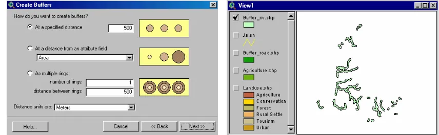
Step 3. Determining site beyond 500 m of existing river
There are two coverages used to determine site beyond 500 m of existing river. They are ‘river’ and ‘linriver’ coverage. First, we have to create buffer to these coverage with distance 500 meters.
A. Buffer of ‘river’
o
Create buffer river with distance 500 m, by click Theme menu\Create bufferfrom toolbar menuo Convert to Shapefile the result of river buffering as ‘Buffer_riv.shp’ as Figure 7.
B. Buffer ‘linriver’
o
Create buffer linriver with distance 500 m, by clickTheme menu\Create bufferfrom menu toolbarFigure 6. Buffer road dialog; and Displaying of the result ‘Buffer_road.shp’
o
Convert to Shapefile the result of linriver buffering as ‘Buffer_linriv.shp’ as Figure 8.C. Union ‘Buffer_riv.shp’ and ‘Buffer_linriv.shp’
o
First, activate Geoprocessing by open the File menu and chose Extensions. In the Extensions dialog, click the GeoProcessing check box and click OK. To begin union process, clickView menuthen choseGeoprocessing Wizard.Define geoprocessing dialog.o
Convert to Shapefile the result of union process as ‘Buffer_river.shp’ as Figure 9.Step 4. Union ‘Buffer_river.shp’ and ‘Agriculture.shp’
A. Manipulating attribute of ‘Buffer_river.shp’
o Open attribute table of ‘Buffer_river.shp’, activated it’s window o ClickTable menuand choseStart Editing
o ClickEdit menuthen choseAdd Field.Fill the Field Definition dialog, then click OK
Figure 8. Buffer linriver dialog box; and Displaying of ‘Buffer_linriv.shp’
o
Sets ‘River_id’ field with number 1, then clicks Stop Editing from menu Table as Figure 11 below:Figure 11. Attributes table of ‘Buffer_river.shp’ after manipulating
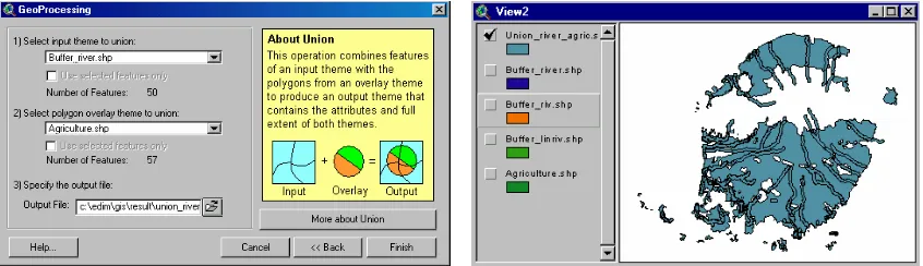
B. Union ‘Buffer_river.shp’ and ‘Agriculture.shp’
o
Create union ‘Buffer_river.shp’ (after attribute manipulating) and ‘Agriculture.shp’ by open View menu then chose Geoprocessing Wizard. Define geoprocessing dialog as Figure 12.o
Convert to Shapefile the result of union process as ‘Union_river_agric.shp’Step 5. Perform query from ‘Union_river_agric.shp’
o Clicks button from menu toolbar, to make query from ‘Union_river_agric.shp’ then
cliksNew Setbutton.
o Convert to Shapefile by clickTheme menu\Covert to Shapefile(as ‘river_agric.shp’)
Figure 12. Union (‘Buffer_river.shp’ and ‘Agriculture.shp’) dialog; and Displaying of the result (‘Union_river_agric.shp’)
Step 6. Intersect between ‘river_agric.shp’ and ‘Buffer_road.shp’ as result (study area)
o From toolbar menu, click View menu\Geoprocessing Wizard\Intersect two theme o Intersect between ‘river_agric.shp’ and ‘Buffer_road.shp’ and get ‘result.shp’ as study
area
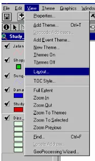
Step 7. Creating Layout
The final step is to make layouts for every step that have been made (each study area). This step can be done by clickingView menu and choose Layout… to make the layouts. The result can bee seen in the appendix 2. All the layouts can be exported into graphic format files (e.g. BMP, JPEG).
Figure 15. Layout functionality in ArcView
Step 8. Avenue Script
Avenue script is used in this assignment as syntax to make two buttons (previous
button and next button ). These two buttons are used to display a series of layouts.
When we click button, the previous layout will be displayed and if we click button, the next layout will be displayed. The result can be shown in this Figure 16. Lists of avenue script used in this assignment can bee seen in Appendix 3.
III. CONCLUSSION
1. Spatial analysis was done using the ArcView Spatial Analyst Extension. The Spatial Analystpresents generic spatial analysis functionality on grid and feature themes that is
added to ArcView as an extension. Among other functionalities the Spatial Analyst
Extension enables the following operations to be carried out: establishing distance,
assigning proximity, calculating density, calculating cell statistics, map querying,
neighborhood statistics, reclassifying, interpolating grid, deriving slope, computing hill
shading and converting to grid.
2. Before doing a decision regarding spatial problem, first we should do geographical analysis to ensure that our location occupy the criteria that has been determined by the user or by the law. There are several commands in ArcView that might be used in performing geographical analysis, e.g. buffering, union, intersect, overlay, attribute manipulation, querying, etc.
3. Buffer analysis is used for identifying areas surrounding geographic features. The process involves generating a buffer around existing geographic features and then identifying or selecting features based on whether they fall inside or outside the boundary of the buffer.
IV. RECOMENDATION