INDOOR LOCALIZATION USING WI-FI BASED FINGERPRINTING AND
TRILATERATION TECHIQUES FOR LBS APPLICATIONS
Solo mon Chan1*, Gunho Sohn1
1GeoICT Lab; Ea rth and Space Science and Engineering Depart ment, York Un iversity, Toronto Canada (sol122, gsohn)@yorku.ca
KEY WORDS : Indoor Localization, Access Points, Trilateration, Fingerprinting, Database, Wi-Fi, RSS, GIS
ABS TRACT:
The past few years have seen wide spread adoption of outdoor positioning services, mainly GPS, being incorporated into everyd ay devices such as smartphones and tablets. While outdoor positioning has been well received by the public, its indoor counterpart has been mostly limited to private use due to its higher costs and complexity for setting up the proper environment . The objective of this research is to provide an affordable mean for indoor localization using wireless local area network (WLAN) Wi-Fi technology. We combined two different Wi-Fi approaches to locate a user. The first method involves the use of matching the pre-recorded received signal strength (RSS) from nearby access points (AP), to the data transmitted from the user on the fly. This is commonly known as “fingerprint matching”. The second approach is a distance-based trilateration approach using three known AP coordinates detected on the user‟s device to derive the position. The combination of the two steps enhances the accuracy of the user position in an indoor environment allowing location-based services (LBS) such as mobile augmented reality (M AR) to be deployed more effectively in the indoor environment. The mapping of the RSS map can also prove useful to IT planning personnel for covering locations with no Wi-Fi coverage (ie. dead spots). The experiments presented in this research helps provide a foundation for the integration of indoor with outdoor positioning to create a seamless transition experience for users.
1. INTRODUCTION
Location-based services (LBS) require on-the-fly localization of the user to provide its service and other information. Indoor localization applications, such as indoor navigation, require precise user location. Since positioning services such as GPS remain inefficient for indoor use, other sensor techniques should be considered. With the maturation in Wi-Fi technologies and the increasing capabilities of hardware in our smart devices, locating a person indoor became a good starting point for providing indoor LBS.
This abstract uses two different Wi-Fi based approaches to locate a person in an indoor space. First step requires the use of fingerprint matching to compare signal strength data received from nearby access points (AP) by the user, to the reference data stored in the Wi-Fi signal strength database. The second method is by means of trilaterating the distances between three known AP coordinates thereby calculating the distance the user is relative to an AP (see Figure 1).
Figure 1 – Steps performed to compute a user’s position
In this abstract, a general overview of an indoor localization system, currently under development, will be presented which is intended to be incorporated into a 3D virtual campus model that has been demonstrated previously in the 6th 3D Geoinfo [6] as shown in Figure 2. Such a system can dynamically represent real world information onto a virtual world thereby increasing the usefulness of 3D semantic data models.
Figure 2 – Indoor 3D models can be a useful aid for visualizing real-time dynamic information such as tracking a moving person [7]
2. MOTIVATION & BACKGROUND
Building on last year‟s success on the integration of dynamic 3D virtual world and tracking moving objects using surveillance video camera, the focus for our group now shifts toward localization using Wi-Fi techniques. We would like to explore the feasibility and compare the accuracy of a visual video based approach for indoor tracking versus a more generalized Wi-Fi based approach.
1. Measurem ents from observer sent to database
2. Perform fingerprint matching
3. Apply trilateratio
n algorithm
Indoor Localization
There are many technologies that can be used for indoor localization and positioning. Radio Frequency ID (RFID), Ultrasound, Infrared Beacons, Bluetooth, Global System for M obile communication (GSM ), Wireless Local Area Network (Wi-Fi), just to name a few. Depending on location and need, one option will be better than another. For instance, using Wi-Fi based methods in a hospital environment could prove dangerous as the Wi-Fi signals could interfere with hospital equipment radio frequency signals. On the other hand, densely placed Wi-Fi AP will provide a solid coverage in most urban settings. Additionally with the number of Wi-Fi capable devices in the market and an abundance of pre-existing Wi-Fi infrastructure at present time, Wi-Fi has become a logical choice to use for tracking and providing LBS to general public.
Recent research such as [7] demonstrates the feasibility of indoor localization and has even been applied into an indoor navigational context operating on an Android device. However, the precision of the user location is not very well explored as the focus of the research was on traversing from point A to B. As such, it is more of a symbolic rep resentation of locations. It is, however, a useful first approximation of the user‟s location.
Bolliger [1], on the other hand, explored the issue of localization accuracy using multiple deterministic and probabilistic methods based on WLAN fingerprinting and tested the feasibility of crowdsourcing to improve the radio map precision in the database. In fact, Bolliger has recently developed an indoor positioning system named Redpin that allows user to voluntarily upload their location to their server to help contribute and enhance the accuracy of their positioning system. By increasing the location point density, the fingerprint matching can also become more precise. And while multiple methods have been considered, they are all fingerprint matching related.
2.1 Positioning VS Localization
A clear distinction should be made between the terms positioning and localization. Positioning is the determination of global world coordinates (ie. 43.77568, 77.12243) while localization is the determination of relative coordinates (ie. Petrie Science and Engineering Building, Room 101) [4].
Positioning is particularly important for trilateration method as coordinates must be known for access points prior to any distance determination. On the other hand, fingerprinting approach is much more reliant on symbolic representation and thus does not require absolute positioning to be known.
2.2 Fingerprinting
Wi-Fi fingerprinting requires a robust RSS database which will be used for generating signal strength maps as well as used for matching. Each reference point includes signal strength measured from all accessible AP. Live RSS data can then be compared to the find the closest match from the database which stores the location of each reference point [5].
Fingerprint matching algorithm generally consists of two components: the radio map and the estimation method. The radio map must be established as part of the training phase to building up the database. The most commonly used estimation method, and also used in this experiment, is the Nearest Neighbour method. Other methods include the Support Vector M achine, as well as Hidden M arkov M odel.
2.3 Trilateration
Trilateration method uses distance from nearby AP with known M edia Access Control (M AC) addresses, calculated from signal strength values, to approximate the distance to the user. It is important to note that different networks of AP, particular ones with different hardware configurations, may vary in calculating the distance. Unlike fingerprinting, this method does not require priori data collection [8].
2.4 Signal Multipath Propagation
In any study involving indoor Wi-Fi signals, one must consider the effect of multipath propagation (ie. reflection and absorption of signals). Due to the nature of multipath, it is important to consider a range of values when trying to match the signal strength with the pre-recorded database values.
3. EXPERIMENTAL S ETUP
To perform localization, a resourceful database with accurate coordinates is needed. Additionally, due to the multipath interference of Wi-Fi signals, it is unrealistic to expect a 100% perfect match in signal between the database and the live feed in signal from the user. Therefore, each reference point uses an average RSS value taken from ~15 seconds worth of signal data. To ensure the effect of multipath fluctuation is minimized, a range of RSS values will be considered as possible candidates. The range will be selected based on the standard deviation of the raw data (ie. standard deviation of ~15 seconds of signal strength values). Trilateration calculations will be computed based on RSS from nearby AP by considering path loss (to be discussed in section 3.4 below).
3.1 Data Collection
The reference data to be used by the database for comparison in the fingerprint matching process consists of 84 locations distributed evenly on floor 1 to 3 of Petrie Science and Engineering (PSE) Building at Yor k Univer sity. The RSS are measured in units of dBm, using the open source software inSSIDer2.0, along with its corresponding M AC address, SSID, channel, etc. inSSIDer2.0 is a freeware used to detect wireless signals in multiple channels and it has been used in previous researches [5] providing accurate data.
All AP in the PSE building are the same Cisco AP1120B model that supports 802.11b band which operates at 2.4GHz range only. The AP are transmitting at full strength at 100mW (corresponds to 20dBm).
3.2 S ystem Requirements
The preliminary system is aimed toward Android users due to its large user base and open source system development . Both smartphone and tablets with an Android OS can install an application that allows RSS data from the device be sent to the database for analysis, thereby computing the user‟s indoor location.
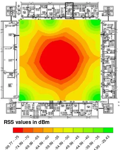
3.3 Radio Map
The CAD floor plans of the PSE building was geo-referenced in ArcGIS as part of the AP mapping process which is required for generating the RSS map. See Figure 3 for a RSS map of the 3rd
measurements were taken in corridors; therefore no empirical RSS data were plotted for the offices and classrooms at the outer ring of the building at this point.
Figure 3 – Received Signal S trength (RSS) radio map for corridors on 3rd floor of Petrie S cience and Engineering Building at York University
3.4 Distance Computation
Computing the distance between the user and a nearby AP requires knowledge of the signal path loss which can generally be represented using the Log-distance Path Loss equation [2]:
(1)
where PL = path loss between sender and receiver = path loss at a distance of 1 meter away d = distance between sender and receiver n = path loss exponent in environment
s = standard deviation of signal strength variability Distance „d‟ from a specific AP can be computed using the above equation. Note that the distance computed represents a radius „d‟ meters around the AP to the user. By considering three nearest distances, trilateration can then be applied to solve for the intersection point where the user would be located. An overview of the system is demonstrated in the flow chart in Figure 4.
Figure 4 – Sequential flowchart presenting the logic of the system
4 PRELIMINARY RES ULTS
4.1 Fingerprinting Approach
An unknown user position was tested in this method as demonstrated below. The user received signals from a list of AP, each with their unique M AC addresses (see Table 1).
MAC Avg RSS addresses is then compared to the master list in the database that stores all detectable M AC addresses within the building. In this particularly case, it can be concluded that the user is at position P0301, as evident from Table 2, which can then be translated from a symbolic point to a real world reference point.
Positio
Positio
Table 2 – Matched each MAC address from the user’s RSS with pre-recorded RSS from database to derive location
4.2 Trilateration Approach
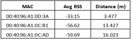
Distance „d‟ has been computed using (1) for the same unknown location as given above with the path loss exponent assumed to be 4 and standard deviation of 8.5 dBm for preliminary testing. Note that the assumed parameters are similar to many other empirically found values [3]. Three known distances away from three AP are then used to derive the intersecting point where the user is located. Table 3 shows the distance computed from three observed strongest RSS in an unknown position.
MAC Avg RSS Distance (m)
00:40:96:A1:0D:3A -33.15 3.477
00:40:96:A1:0C:B1 -56.62 13.427
00:40:96:A1:0C:AD -59.69 16.023
Table 3 – Computed the distance away from each AP from the user measured RSS
Finally a local coordinate (x,y,z) can then be deduced to locate the position.
5. CONCLUS ION AND FUTURE WORKS
In the preliminary round of experimentations, the results are crude and still have many untested cases. The probability of finding the correct match for the fingerprinting method can be significantly improved by incorporating certain database
correlation algorithms such as K nearest neightbours or probabilistic algorithms like Hidden M arkov M odel. There are difficulties in the current system to compute an accurate elevation using the trilateration method largely due to the inability to find a common intersection point from all three distances simultaneously. While these results seem to suggest that three dimensional localization is possible, at least in regards to fingerprint matching, further experimentations are required to tune this system. M uch still needs to be done before integrating with the 3D virtual models.
The experiments presented in this research helps provide a foundation for the integration of indoor with outdoor positioning. Combination of indoor localization techniques with existing outdoor positioning tools allows a full indoor/outdoor spatial coverage which can greatly enhance a user‟s experience. Furthermore, high precision indoor localization can be integrated with location-based services such as indoor navigation or mobile augmented reality for indoor spatial mining.
6. ACKNOWLEDGEMENTS AND REFERENCES
The author would like to thank Brian Kim for his assistance in collecting signal strength data, and the Information Technology Services Department at Yor k Univer sity for providing the AP information for PSE Building.
[1] Bolliger Philipp Lukas, “Robust Indoor Positioning through Adaptive Collaborative Labeling of Location Fingerprints”, PhD‟s thesis, ETH Zurich,
http://e-collection.library.ethz.ch/eserv/eth:5267/eth-5267-[3] Faria Daniel B., “Modeling Signal Attenuation in IEEE 802.11 Wireless LANs –Vol. 1”, Standord university, 2006
[4] Haenselmann Thomas, 2005. “Lecture on Sensor Networks”, University of M annheim, Germany. http://www.slideshare.net/netfet/localization-presentation (13 Jan. 2012).
[5] Navarro Eduardo, 2011. “Wi-Fi Localization Using RSSI Fingerprinting”, California Polytechnic State University,
United States of America.
http://digitalcommons.calpoly.edu/cpesp/17/ (17 Aug. 2011)
[6] Sohn Gunho, Wang Langyue, Persad Ravi, Chan Solomon, “Towards Dynamic Virtual 3D World: Bringing Dynamics into Integrated 3D Indoor and Outdoor Virtual World”, 3DCMA 2011 & The 6th 3DGeoinfo
[7] Stook Justin, 2011. “Planning an indoor navigation service for a smartphone with Wi-Fi fingerprinting localization”, Master's thesis GIM A (Utrecht Univ., TU Delft, Wageningen Univ., ITC), 2011, 145 p. http://www.gdmc.nl/publications/2011/Indoor_Navigation_Serv ice_Smartphone.pdf
University of Saskatchewan, Canada. http://rose.geog.mcgill.ca/ski/system/files/fm/2011/Wei.pdf (2 June, 2011)