isprs archives XLI B5 741 2016
Teks penuh
Gambar

Garis besar
Dokumen terkait
Writing at the time of intense debate on a new law that regulates a wide range of data collection and surveillance capabilities, we analyze the breadth of
DAFTAR BLOK PENGELOLAAN KAWASAN KONSERVASI SAH SAMPAI DENGAN
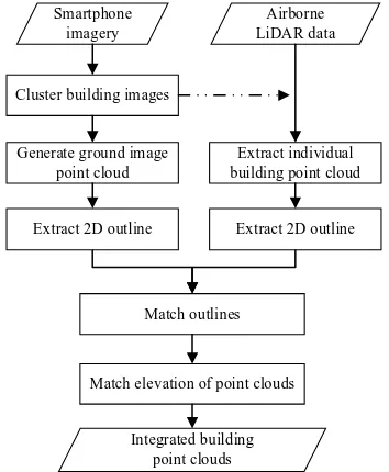
[r]
[r]
Now I attend UN climate conferences and other REDD+ events and I know what people are talking about,” says Vu Thi Bich Hop, Director of Sustainable Rural Development in Vietnam,
Lembar observasi dalam penelitian ini bertujuan untuk memberikan gambaran secara lengkap bagaimana penerapan model Quantum Teaching juga nantinya akan memberikan
[r]
sampai dengan akhir tahun anggaran 2014 penyerapan anggaran yang paling.. tinggi terjadi pada Kabupaten Serdang Bedagai sebesar 92,69% tetapi
![BIRO KEUANGAN SETDA PROV. SULBAR [Paket Penyedia].](data:image/gif;base64,R0lGODlhAQABAIAAAP///wAAACH5BAEAAAAALAAAAAABAAEAAAICRAEAOw==)