USAGE OF STEREO ORTHOIMAGE IN GIS:
OLD CONCEPT, MODERN SOLUTION
K. Pyka a, M. Słota a, M. Twardowski a
aDept. of Geoinformation, Photogrammetry and Remote Sensing of Environment,
Faculty of Mining Surveying and Environmental Engineering, AGH University of Science and Technology, Krakow, Poland - krisfoto@agh.edu.pl
Commission IV/II, WG IV/1,4,5, II/2,6,8
KEY WORDS: Photogrammetry/GIS, Visualization, Orthorectification, Stereoscopic
ABSTRACT:
The main goal of this paper is to find answer for two questions: why stereo orthoimage (orthophoto) was forgotten, and furthermore, what conditions have to be fulfilled for this particular technique to be reanimated?
Stereo orthophoto concept was first introduced by Collins, during late seventies of last century (Colins, 1968). It has ignited huge interest, and many researchers were looking forward for its development (Blachut 1976, Kraus et al. 1976). However, after around twenty years, interest in stereo-orthophoto has shrunk, and during eighties of XX century it was almost extinct. Despite of fact that digital photogrammetry provides better conditions for it now than ever, it has never got chance for reactivation. There was but few papers about stereo orthoimage, and they are proposing continuous stereo ortho-mosaic generation while preserving its metric value (Li et al 2002, Wang 2004).
Reasons of downfall of this interest were examined, and it has been concluded that the main cause was usage of this technique in conjunction with analog photogrammetry. The radiometric value of orthophotomaps and stereo components developed on photosensitive paper were very low during that time. Equipment for observation and measurement were simply very big and therefore impractical. Authors have concluded, that nowadays sum of gains outweighs its flaws and it is reason enough to go back to it. But in a time of digital vector 3D models there is a need for proper strategy for popularization stereo orthophoto. Main point of this strategy would be encapsulating stereo orthoimage method into GIS tools, optimally open source. GIS have large numbers of consumers whom regard for orthophotomap (or orthoimage) is very high. If they were to be proposed with possibility of using stereo orthoimage inside a GIS tool, as a complementary to the orthophotomap, probably they would recon how much stereoscopy helps with interpretation of an image.
Authors have planned to develop software for utilization of stereo orthoimage available from the Quantum GIS interface, and test version is to be based on anaglyph stereoscopy. Value of creating continuous stereo-mosaic composed from many 3D models was assessed. Consensus was, however, that this solution surprises us with frequent perspective changes which leads to discomfort. As an outcome it was decided to focus on single stereo orthoimage pairs. When area constrains are specified for single model, one can load them as requested by an user. In case of increased lateral and longitudinal coverage, which is more common in modern aerial photogrammetric flights, every localization will be accessible for visualization using several models, and there will be less concealed areas.
Few algorithms for generation of parallax are tested. After completion of sets from a dozen or so example models of interesting areas are gathered, there will be release. Authors are confident that stereo orthoimage may prove more useful for GIS users than true orthophotomap.
1. INTRODUCTION
The concept of stereo orthophoto technique published by Collins44 years ago (Collins, 1968) quickly became a subject of research and implementation. A number of devices with 3D stereo orthophoto measurement capabilities have been built. Accuracy of those devices has been tested (Real et al 1974, Jachimski 1978, Kraus et al 1979) and possible application areas have been indicated (Błachut, 1971, 1976). However after about 10 years, further development of the stereo orthophoto technology had been discontinued, probably because of the occurring disadvantages, such as very large size of measuring devices or poor quality of available photographic materials. These disadvantages discouraged potential users, which would have been architects, geologists, foresters, topographers, etc. This slightly forgotten technique was reinstated in the 90s, when GIS had been already well developed (Sarjakoski, 1990, Baltsavias, 1996, Li et al 1996). In the last decade some visible
attempts to return to the stereo orthophoto technique with a greater emphasis on GIS applications have been made(Li et al 2002, 2009, Wang, 2004, Chang et al 2008). While orthophotos have been firmly established in the GIS environment, stereo orthophotos are still scarcely used.
The purpose of this article is to present possibilities of broader use of the stereo orthophoto technology in GIS. According to the authors ,the original Collin’s and Blachut’s idea to introduce the stereo orthophoto to the wide range of users is worth reinstating. It could be achieved by strong technique implementation in the GIS technology.
2. STEREO ORTHOPHOTO PRINCIPLES
The term stereo orthophoto refers to the pair of images, where one of the images is a classic orthophoto and the other one is a
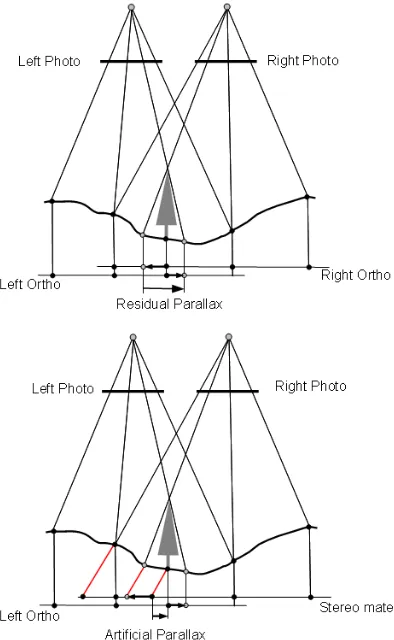
quasi-orthophoto. This quasi-orthophoto is created from an adjacent image by introducing artificial longitudinal parallax during orthorectification process in order to achieve fully metrical 3D model. Created pair of images not only inherit the artificial parallax but residual parallax as well. This residual parallax is generated for the objects protruding from the terrain in the classical orthorectification process of two neighbouring aerial images.
Stereoscopic vision of the height differentiation of the terrain is possible because of the presence of the artificial parallax, while height of the objects protruding from the terrain – through the residual parallax. Objects protruding from the terrain and not being orthorectificated, such as buildings, chimneys, towers or trees are called vertical objects in the next parts of this article. There are some alternative versions of stereo orthophoto possible. One of them relies on stereopair creation based on only one photo however stereoscopic effects is achievable only for the terrain. Observation of two overlapping orthophotos without stereo mate component is another option, but stereoscopic effect in this case is limited to vertical objects visible on the flat terrain background.
The principles of “full version” of stereo orthophoto generation, which provides stereoscopy effect for both the terrain and vertical objects are presented in the figure 1. Upper part of the figure explains why, between orthophotos generated from left and right images residual parallax is formed for the vertical objects. The scheme of stereo mate generation is shown in the lower part of the figure. In the process of the right image orthorectification orthogonal projection is replaced by quasi-parallel projection of the terrain points.
Figure 1. Principles of stereo orthophoto generation.
The mathematical function that links artificial parallaxes with the terrain elevation model could be linear, which corresponds with the slope parallel projection. However better results could be achieved by introducing logarithmic function into projection (Collins, 1970) as shown in the equation 1:
h H
H B P
− ⋅
= ln (1)
where P - artificial parallax, B - base line of photograph,
H - flight height above the reference level, h - terrain height/elevation above reference level.
Parallax calculation from equation 1 not only improves accuracy of stereo orthophoto height measurement but positively influences balance between the artificial and residual parallax with parallel projection and variable angle method (Li et al 2002).
Figure 1 presents situation, where area around the vertical object is relatively flat. In such case residual parallax calculated from the equation 2 is a good height indicator. However, if the object is located in mountainous terrain, especially at the top of the mountain or in the middle of the valley, then the residual parallax is distorted, what introduces errors in vertical objects height determination. This explains worse accuracy of stereo orthophotos in mountainous terrains (Figure 2).
Figure 2. Residual parallax distortion for vertical objects in mountainous areas.
H
c
B
p
p
H
h
∆
⋅
+
∆
∆
⋅
∆
=
∆
(2)where ∆h – height of object relative to its base, ∆p – residual parallax,
B – base line of photograph, c – focal length,
∆H – flight altitude above vertical object position.
3. CONDITIONS OF STEREO ORTHOPHOTO POPULARIZATION
Stereo orthophoto enhances flat photographic form of the world representation by introducing the third dimension. Both photogrammetric products have many features in common, however only orthophotos are generally recognized. Fact is, that stereo orthophoto was originally introduced when technical incapabilities limited straightforward use of all product advantages. Rapid technology development in recent years dramatically improved the standards of photogrammetric products, especially in terms of the radiometric quality. However technology development has not affected significance of stero orthophotography, but has considerably strengthened the orthophoto position in GIS environment and in geoportal sites.
Strong orthophoto position in the GIS is justified by two-dimensional, layered GIS information structure, the third dimension is loaded from DTM (2D+1D strategy, also known as 2.5D). Orthophoto is treated as one of the many information layers, which satisfies most of the end users. The GIS transformation into full 3D system is currently at the initial stage and results achieved so far could be qualified more as 3D cartography than GIS.
Could stereo orthophoto technology gain more popularity? The authors believe that the answer to this question is positive but only after meeting a number of conditions. One of them is perceiving the stereo orthophoto as a support material, not as an othophoto substitute. Inducing potential users to complete resignation from orthophoto for the benefit of the product that requires additional hardware for stereoscopic observation, would be a mistake. Stereoscopy effect can be achieved by an anaglyph technique, which requires very simple and cheap filter glasses. This technique, however, cannot guarantee preservation of full colour palette on the image. On the other hand professional stereoscopy requires an appropriate graphic card and special monitors with adequate glasses, which could be a major investment. Therefore, stereo orthophotography should be implamented in the GIS as an additional option, used only when orthophoto does not provide sufficient information. The possibility of 3D measurement is an additional advantage, but not necessarily appreciated by all GIS users.
Another important aspect of stereo orthophoto propagation strategy is utilization of the popularity of open source software. Several valuable GIS tools have been created within the open source market with a number of users around the world. The first open source GIS software worth pointing out is fast developing QuantumGIS, which despite of being used in typical amateur applications, works well in a major, professional projects. Key advantage of such tools is possibility of easy extension of the program by adding specialist plugins, such as an application for displaying prepared sets of stereo orthophotos in anaglyph technique with the possibilities of 3D measurement and vectorization.
Next aspect worth consideration is the availability of the data. And once again orthophoto is in the better situation. In many countries orthophoto data are gathered from governmental projects in cycles of several years. Such data are usually available for a small fee, while reviewing the othophothos with WMS services is free. Stereo component generation procedure from single orthophoto is quite easy, but stereo model obtained in this way applies only for the terrain. In order to achieve
“full” stereoscopy effect both DTM and all othophotos (not only mosaic of them) or all original images with orientations are needed.
Method proposed by Li and Wang (Li et al 2002, Wang 2004, Li et al 2009) of using the odd and even images separately from photogrammetric block with 60% coverage is interesting from stereo orthophoto populization point of view. In this solution two mosaics are generated – one based on the othophotos from odd images and other mosaic from stereo mates created for even images. Production cost of such data should not be considerably higher than production of traditional orthophoto based mosaics. Commonly used all orthophotos mosaicing method into sections of orthophotomaps is an anachronism, because today’s photogrammetry products guarantee proper level of accuracy not only for regions around the centre of photo but for all image area.
As the above arguments suggest conditions of stereo orthophoto populatization are complex and difficult to meet. On the other hand the strength of the open source movement is so immense that is worth entrusting. Therefore, authors decided to develop QuantumGIS plugin application, allowing stereo orthophoto observation and 3D measurements.
4. APPLICATION BASIC ASSUMPTIONS FOR STEREO ORTHOPHOTO
After several considerations for building computer application, designed for displaying and measurement of stereo orthophoto, following assumptions were made:
a) application will be working as a plugin in QuantumGIS environment and will be written using C++ language, with possible bindings to Python, b) stereoscopy will be carried out with orthoimage
prepared from left photograph and stereo component prepared from right photograph. Optionally DTM used for orthorectification may be utilized,
c) plugin will provide possibility of stereo observation with full stereoscopy (chapter 2) and XYZ coordinate measurement,
d) anaglyph images will be used to achieve stereoscopic effect.
QuantumGIS environment imposes requirement for using dynamic loading libraries, “dll” files in case of Windows system, or “so” libraries in case of Linux. During compilation those libraries have to satisfy not only dependencies of QuantumGIS itself, but also dependency of popular Qt library have to be fulfilled. It is used as a toolkit for providing user interface, and initially Qt is meant to serve as facility to enable specification of parameters for anaglyphs prepared previously. But wide variety of functions included in this library does not exclude possibility of creating accelerated OpenGL context and following potential of stereoscopic visualisation thorough shutter glasses, or even equally popular polarisation technology. At the same time QuantumGIS standard libraries provide QgsRasterLayer class, member functions of which allow for adding images in all image formats supported by GDAL library. Furthermore, available public member function setCrs, which is inherited from its parent class QgsMapLayer should allow for manipulating layer coordinate system, providing way to impose proper parallax between stereo pair. One could assume that those features should be enough to build application in question.
Assumption b) implies that data have to be previously prepared, outside of QuantumGIS environment. Certainly this is significant obstacle for an user, who has to order preparation of stereo component from orthophoto supplier (there is a module for generating stereo component in some photogrammetric software like Erdas or SocetSet). On the other hand there is no justification for need to create stereo ortophoto from aerial photographs in QuantumGIS itself. Considering this, user would have to know photogrammetric production line, and this contradicts popularisation of stereo visualisation among large number of recipients of GIS, which we are after. Besides, for that to happen user would need photographs along with orientation elements. Knowing that preparation of stereo components isn't significant increase of effort in comparison to standard orthophoto creation procedure, one could hope that in short amount of time adequate data will surface provided by internet GIS oriented sites using WMS technology. Obviously WMS can be used as standard facility for providing anaglyph images. Therefore there are grounds for assumption that user would have access to stereo data without any special effort on his part. Such futuristic solution blend itself well into prerequisites of popularisation of stereo orthophoto among wide circle of GIS recipients presented in chapter 3.
Stereo orthophoto flaw as shown in chapter 2 , namely distortion of height for vertical objects located in mountainous areas, can be corrected during measurement by introducing adjustments calculated from DTM. That is why such functionality is to be optionally included in developed application, and it is the reason why it was pointed out in assumption b) as a component of input data.
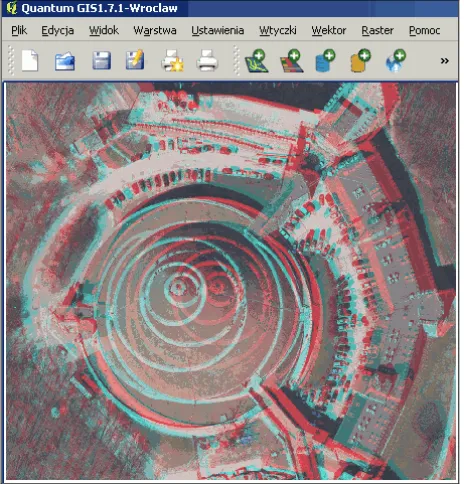
Currently prototype application is being developed. As an intermediate solution on the way to achieve our goal stereoscopy tests are limited to vertical objects, or employing residual parallax between two orthoimages generated from adjacent photographs. Figure 3 shows such an anaglyph pair operated in QuantumGIS.
Fig. 3. Example visualisation of stereo orthophoto in QuantumGIS environment (courtesy of MGGP AERO
Company, Tarnow, Poland).
5. CONCLUSIONS
The prospect of stereo orthophoto technique renaissance is very promising, especially now in the era of digital photogrammetry and advanced GIS development. In many countries, including EU members, the governmental photogrammetry projects are regularly conducted for cultivation control purposes, producing valuable sets of data. By using this existing data the stereoscopic pairs could be created with relatively little effort. The best way of stereo orthophoto popularization is GIS – the means of reaching out to wide variety of users.
Stereo orthophoto does not compete with 3D vector models, since it is a totally different product, with a lot of advantages but also a few flaws. Stereo orthophoto should be perceived as a supplement of othophoto – so well adapted by geoinformation community.If users accepted orthophoto’s visual model of reality, they should also accept the opportunity of seeing and exploring this model in 3D. One of the most important advantage of the stereo orthophoto product is its metrics, although slightly lower than obtain from classical photogrammetric models, but enough for many GIS tasks. The significant accuracy decrease, pointed in some publications (Li et al 2002, Wang 2004), of stereo orthophotos compared to classical photogrammetric models has not been confirmed during authors’ research on photogrammetric data of digital camera images. Worth mentioning is the advantage of using digital camera with quite narrow field of view in mountainous areas due to minimization of the residual parallax distortion. Moreover, there is the possibility of compensating this deformations, which will be one of the option in created application.
An essential condition for popularization of the stereo orthophoto is for geoportals to publish relevant data. Currently public and commercial geoportals offer only an orthophoto mosaics. However there is the potential for similar mosaics generation from stereo components. Production cost of such data is significantly lower than production of 3D, textured models - currently provided by a several commercial geoportals.
REFERENCES
Baltsavias E.P., 1996. Digital ortho-images — a powerful tool for the extraction of spatial- and geo-information. ISPRS Journal of Photogrammetry and Remote Sensing ,Vol. 51, Issue 2, pp. 63-77.
Blachut, T.J., 1971. Mapping and Photointerpretation System Based on Stereo-Orthophotos. ETH Zurich.
Blachut, T.J., 1976. The Stereo-Orthophoto Technique in Cadastral and General Mapping. Photogrammetric Engineering and Remote Sensing, 42(12), pp.1511-1519.
Chang H., Yu K., Joo H., Kim Y., Kim H., Choi J., Han D.Y., Eo Y.D., 2008, Stereo-mate generation of high resolution satellite imagery using a parallel projection model. Can. J.Remote Sensing vol. 34, pp. 57-67
Collins, S.H., 1968. Stereoscopic orthophoto maps. The Canadian Surveyor, 22(1), pp. 167-176.
Collins S.H., 1970.The Ideal Mechanical Parallax for Sterro-orthophoto.The Canadian Surveyor, 24(5) , pp. 561-568
Jachimski J., 1978. Stereoscopy problem in Orthophotography. AGH Cracow 1978.
Kraus, K., Otepka, G., Lottsc, J. and Haitzmann, H., 1979. Digitally Controlled Production of Orthopotos and Stereo-Orthopotos. Photogrammetric Engineering and Remote Sensing, 45(10) , pp. 1353-1362.
Li, D. R., Wang, S. G. and Li, R. X., 1996. Automatic quality diagnosis in DTM generation by digital image matching techniques. GEOMATICA, 50(1), pp. 65-73
Li D. R., Wang M., Gong J. Y., 2002. Principle of seamless stereo orthoimage database and its measurement accuracy analysis. Proceedings of the ISPRS Commission III Symposium, Graz, Austria, pp: 151-156.
Li D., Wang M., Hu Q., Hu F., 2009. On three-dimensional visualization of geospatial information: graphics based or imagery based? Annals of GIS, 15:2, pp 75-84.
Real R., Fujimoto Y., Moeller H, Paulun.M., 1974, An Electroning Drawing Aid for map Compiling. I.E.E.E. Trans. Geo-science Electronics, vol. G.E.-12, p.134.
Sarjakoski, T., 1990. Digital stereo imagery--a map-product in the future? Proceedings of the ISPRS Commission IV Symposium, Tsukuba, Japan, pp.200-210
Wang M., 2004. A New Approach for Generating a Measurable Seamless Stereo Model Based on Mosaic Orthoimage and Stereomate. The International Archives of the Photogrammetry, Remote Sensing and Spatial Information Sciences, Congress Istanbul 2004, Vol. XXXV, Part B1.
ACKNOWLEDGMENTS
The investigation has been made within the scope of research project AGH 11.11.150.949