O
PEN
G
EOSPATIAL
C
ONSORTIUM
(OGC)
P
HASE
1 R
EPORT
: S
PATIAL
D
ATA SHARING FOR THE
A
RCTIC
OGC Arctic Spatial Data Pilot
OGC Arctic Spatial Data Pilot
Phase 1 Report: Spatial Data Sharing for the Arctic
The Open Geospatial Consortium (OGC˝o)
35 Main Street, Suite 5 Wayland, MA 01778 Telephone: +1-508-655-5858
Acknowledgements
The OGC expresses its gratefulness to its sponsors US Geological Survey and Natural Resources Canada for supporting this work. OGC further wishes to ex-press its gratitude to the following companies and organizations, who provided excellent contributions that have been used in excerpts in this report.1
Organization / Company
Federal Geospatial Platform Project, Federal Committee on Geomatics and Earth Observations (FCGEO) National Snow and Ice Data Center
NGA Maritime Safety Office NOAA Coast Survey
Polar Community (for details see AppendixD) Polar Knowledge Canada
Public Safety Geoscience Program (Earth Sciences Sector, NRCan) Pyxis
University Carleton, GCRC University Grenoble-Alpes University of North Carolina
W3C Maps for HTML Community Group Yukon Government
TABLE1: Organizations and companies contributing to this report
1To avoid an overload with references, in particular as paragraphs often include parts
pro-vided by different companies or organizations, this report does not include local references other than for images.
OPEN GEOSPATIAL CONSORTIUM (OGC)
Abstract
Phase 1 Report: Spatial Data Sharing for the Arctic
OGC Arctic Spatial Data Pilot
by OGC
This report presents the results of a concept development study on SDI for the Arctic, sponsored by US Geological Survey and Natural Resources Canada, ex-ecuted by the Open Geospatial Consortium. The focus of this study was to understand how to best support the development of an SDI for the Arctic, to understand the view and specific requirements of indigenous peoples in the North, and how to make existing implementations i) better known to stake-holders, and ii) better serving stakeholders’ needs. The study included an open Request for Information(RFI) with the objective to gather external positions and opinions on the optimal setup and design of an SDI for the Arctic. Responses to this RFI have been integrated into this report.
The report discusses the various types of stakeholders of an SDI for the Arc-tic with their specific needs and requirements on aspects such as data sharing, standards & interoperability, funding and investment, integration with existing systems, architecture and platform as well as security, privacy, and safety. The report further discusses various architecture models with focus on standards required to optimize discovery, usage, and processing of data in an highly het-erogeneous network of SDI data and service providers. The report concludes with a number of demonstration scenarios that could be used in the pilot’s sec-ond phase to demonstrate the value of an SDI for the Arctic to a broad range of stakeholders.
8 Applications 77
9 Use Cases & Scenarios 81
9.1 Linking Indigenous and Scientific Knowledge . . . 81
A Appendix: Stakeholders: Individual points of contact 88 B Appendix: Governance Lessons Learned 90 C Appendix: Polar Data Portals 92 D Appendix: Polar Community 99
E Appendix: A Semantic Web Driven Application Scenario 105 F Appendix: Indigenous Peoples 115 F.1 Context . . . 115
F.2 Arctic . . . 116
F.3 Consultation . . . 117
F.4 Ownership, Control, Access and Possession (OCAP) Principles . 117 F.5 Land Use and Occupancy Mapping . . . 118
F.6 Indigenous Communities Strengthen Governance with Location-based Tools in the 21st Century . . . 118
F.7 Cultural Sensitivities and Considerations in Mapping . . . 119
F.8 Indigenous Community Land and Resource Management Geospa-tial Data Needs Assessment . . . 119
F.9 Sensitive Information . . . 120
F.10 Indigenous Mapping Program. . . 120
Bibliography 121
List of Figures
2.1 Types of stakeholders . . . 11
2.2 Business needs examples, part 1. . . 16
2.3 Business needs examples, part 2. . . 17
2.4 Business needs examples, part 3. . . 18
2.5 Business needs examples, part 4. . . 19
3.1 High level requirements categories . . . 25
4.1 High level governance goals . . . 33
5.1 Architecture . . . 37
5.2 Components of a modern data platform . . . 40
5.3 Knowledge generation perspective . . . 42
5.4 Closely architected approach . . . 43
5.5 Loose confederation approach . . . 45
5.6 Ontology and triple store based approach . . . 46
5.7 Aspects of openness . . . 47
6.1 Polar scientific activities part 1 . . . 53
6.2 Polar scientific activities part 2 . . . 54
6.3 Polar operational activities . . . 55
6.4 Federal Geospatial Platform Project data . . . 62
9.1 United Nations Sustainable Development Goals . . . 86
B.1 Governance lessons learned, part 1 . . . 90
B.2 Governance lessons learned, part 2 . . . 91
F.1 Regional Indigenous Identity Population Proportions . . . 116
F.2 Cultural Sensitivities and Considerations in Mapping . . . 119
List of Tables
1 Organizations and companies contributing to this report . . . ii
2.1 Overview of the Arctic Data Stakeholders . . . 12
List of Abbreviations
Arctic-SDI Arctic Spatial Data Infrastructure
ArcticSDP Arctic Spatial Data Pilot
AIS Automatic Identification System (AIS) messages
CAAS Communication as a Service
CGDI Canadian Geospatial Data Infrastructure
CGNDB Canadian Geographical Names Data Base
CSV Comma Separated Values
EOWCS Earth Observation Profile Web Coverage Service
FGDC Federal Geographic Data Committee
GEO Group on Earth Observation
GEOSS Global Earth Observation System of Systems
GeoXACML Geospatial XACML
NASA National Aeronautics and Space Administration
netCDF network Common Data Form
NOAA U.S. National Oceanic and Atmospheric Administration
NRCan Natural Resources Canada
NSDI National Spatial Data Infrastructure
NWT Northwest Territories
NWTCG The Northwest Territories Centre for Geomatics
OGC Open Geospatial Consortium
OPeNDAP Open-source Project for a Network Data Access Protocol
PaaS Platform as a Service
POI Points-of-interest
RDF Resource Description Framework
RFI Request For Information
RFQ Request For Quotation
SaaS Software as a Service
SDI Spatial Data Infrastructure
SOS Sensor Observation Service
SPARQL SPARQL Protocol and RDF Query Language
SWE Sensor Web Enablement
SWG Standards Working Group
UN-GGIM United Nations Committee of Experts on Global Geospatial Information Management
U.S. United States
USGS U.S. Geological Survey
W3C World Wide Web Consortium
WCPS Web Coverage Processing Service
WCS Web Catalog Service
WFS Web Feature Service
WMS Web Mapping Service
WMTS Web Mapping Tile Service
WPS Web Processing Service
WS Web Service
WSDL Web Services Description Language
XACML eXtensible Access Control Markup Language
Chapter 1
Introduction
The polar regions are of increasing interest to the whole world as a result of their linkage to global climate systems, opportunities for economic develop-ment, geo-political strategic importance, and their environmental importance as homes to Indigenous populations and other residents and sensitive ecosys-tems. Polar data are required by the scientific community and residents to sup-port research on topics such as climate, atmosphere, land, oceans, ecosystems, ice and snow, permafrost, and social systems; and by the operations commu-nity to support impact assessments, engineering design, safe navigation and operations, risk management, emergency response, weather forecasting, and climate change adaptation. These activities contribute to environmental protec-tion, heritage preservaprotec-tion, economic development, safety of life and property, and national sovereignty.
The polar data community is well organized and is pursuing activities to im-prove data management for all of the diverse members of the polar community. Polar data infrastructure is evolving from a system where data are discovered in data catalogues and downloaded to the local machines of users, to a system of distributed data made interoperable using standards and providing users with storage and computational capacity close to large repositories of data.
Interoperability and open standards are core to any spatial data infrastructure for the Arctic, as they enable the exchange of data and the use of processing, vi-sualization, and representation services in distributed systems most efficiently. The economic benefits of building systems based on standards has been shown in many studies (e.g. DIN 2011). This pilot will demonstrate the value of stan-dards in an environment that is principally built as a system of systems, i.e. an Arctic Spatial Data Infrastructure that integrates a number of existing systems as well as individual services and data repositories.
Chapter 1. Introduction 2
Indigenous Peoples of the Arctic and their representative organizations are in-creasingly active in using information and communications technologies (ICT) to access data and share their information and knowledge. This includes the establishment of protocols for ethical and culturally appropriate development of ICT.
This report presents the results of a concept development study on SDI for the Arctic, sponsored by US Geological Survey and Natural Resources Canada, ex-ecuted by the Open Geospatial Consortium. The focus of this study was to understand how to best support the development of an SDI for the Arctic and how to make existing implementations i) better known to stakeholders, and ii) better serving stakeholders’ needs. The study included an openRequest for In-formation(RFI) with the objective to gather external positions and opinions on the optimal setup and design of an SDI for the Arctic. Responses to this RFI have been integrated into this report.
The report discusses the various types of stakeholders of an SDI for the Arc-tic (chapter 2) with their specific needs and requirements on aspects such as data sharing, standards & interoperability, funding and investment, integration with existing systems, architecture and platform as well as security, privacy, and safety (chapter3). The report further discusses governance goals (chapter
4) before concentrating on more technical aspects such as architecture models (chapter5), data (chapter6), and standards & interoperability aspects (chapter
7) to optimize discovery, usage, and processing of data in an highly heteroge-neous network of SDI data and service providers. The report concludes with a number of demonstration applications scenarios that could be used in the pi-lot’s second phase to demonstrate the value of an SDI for the Arctic to a broad range of stakeholders (chapters8and9).
1.1
Pilot Participants and Goals
Chapter 1. Introduction 3
and Indigenous Communities, working in zero/low bandwidth regions and considering the realities of frontier economies.
The Arctic SDI will play a key role in a range of complex issues where geospa-tial data are necessary, such as responsible resource development, environmen-tal management and assessment, regulatory reviews, and safety and security. The Arctic SDI aims to make geospatial information available in a standardized way to the public, academic institutions, the private sector and others who are involved in to conducting research or produce value-added products and appli-cations, driving innovation and stimulating economic development. Geospa-tial data, services and applications accessed through Arctic SDI will help agen-cies understand the impact of climate change and human activities in the Arc-tic, facilitating monitoring, management, emergency preparedness and deci-sion making. Moreover, Arctic SDI will support Canadian research on climate change and enable decision-makers to take effective decisions and implement mitigation strategies.
Organization managing the RFI
TheOpen Geospatial Consortium (OGC)is an international consortium of more
than 500 companies, government agencies, research organizations, and univer-sities participating in a consensus process to develop publicly available geospa-tial standards. OGC standards support interoperable solutions that "geo-enable" the Web, wireless and location-based services, and mainstream IT. OGC stan-dards empower technology developers to make geospatial information and ser-vices accessible and useful with any application that needs to be geospatially enabled.
Sponsors
Natural Resources Canada (NRCan)seeks to enhance the responsible
develop-ment and use of Canadas natural resources and the competitiveness of Canadas natural resources products. We are an established leader in science and technol-ogy in the fields of energy, forests, and minerals and metals and use our exper-tise in earth sciences to build and maintain an up-to-date knowledge base of our landmass. NRCan develops policies and programs that enhance the contri-bution of the natural resources sector to the economy and improve the quality of life for all Canadians.
Chapter 1. Introduction 4
analyzes data and information, and provides scientific understanding about natural resource conditions, issues, and problems. The diversity of its scientific expertise enables USGS to carry out large-scale, multi-disciplinary investiga-tions and provide impartial scientific information to resource managers, plan-ners, and other customers.
1.2
ArcticSDP: CGDI, NSDI and Arctic SDI
Link-ages
There are a number of SDI initiatives addressing the Arctic region, such as the US National Spatial Data Infrastructure (NSDI) or the Canadian Geospa-tial Data Infrastructure (CGDI). Other initiatives, such as the Arctic Council endorsed Arctic SDI address the entire Arctic region based on a cooperation between the mapping agencies of the eight bordering states. From a Canadian perspective, Arctic SDI addresses all SDI elements of the Canadian Geospatial Data Infrastructure primarily north of 60 degrees latitude (i.e. Canadian Ter-ritories, Northern Quebec and Northern Labrador), which assist regional, na-tional and internana-tional SDIs. The US definition addresses the compatibility of USGS and the FGDC role in supporting national and international SDIs. Both the NSDI and CGDI (or the USGS and NRCan as organizations respectively) are contributing to the development and sustainability of the Arctic Council endorsed Arctic SDI.
For this RFI, the termArctic SDIis also used generically for an SDI that serves Arctic data and services. Arctic SDI is further used for an SDI of several fla-vors. It is part of national SDIs that address the Arctic region and it is a coop-eration between eight national mapping agencies with their internet platform featuring an Arctic data portal and Web services. Thus, it combines the various perspectives based on the rationale that there is a reciprocal influencing and de-pendency process between national (and even sub-national) and international initiatives addressing the Arctic region.
Chapter 1. Introduction 5
1.2.1
National Spatial Data Infrastructure (NSDI)
"The NSDI has come to be seen as the technology, policies, criteria, standards and people necessary to promote geospatial data sharing throughout all levels of government, the private and non-profit sec-tors, and academia. It provides a base or structure of practices and relationships among data producers and users that facilitates data sharing and use. It is a set of actions and new ways of accessing, sharing and using geographic data that enables far more compre-hensive analysis of data to help decision-makers choose the best course(s) of action."FGDC
The vision of the NSDI is to leverage investments in people, technology, data, and procedures to create and provide the geospatial knowledge required to understand, protect, and promote national and global interests.
According to theNational Spatial Data Infrastructure Strategic Plan 2014-2016, the Arctic Spatial Data Pilot addresses a number of desires the NSDI shall fulfill in the near future:
• Provide government, businesses, and citizens with a way to visualize and explore data to derive information and knowledge.
• Create a network of resources and services for the seamless integration of location-based information into broader information assets to serve the needs of government, the business community, and citizens.
• Serve as an enabling resource for discovery, access, integration, and ap-plication of location information for a growing body of users.
• Leverage shared and open standards-based services and focus on applied information for improved decision-making.
• Promote place-based business intelligence and smart, shared applications.
• Include a core set of information layers that interface with other non-spatial data being generated.
• Use real-time data feeds and sensor webs for improved monitoring, con-trol, situational awareness, and decision-making.
Chapter 1. Introduction 6
• Integrate and use advanced technologies and their associated standards and best practices.
• Facilitate use of community-driven open standards with multiple imple-mentations.
1.2.2
Canadian Geospatial Data Infrastructure (CGDI)
The Government of Canada creates an environment for the development of the Canadian Geospatial Data Infrastructure (CGDI). Natural Resources Canada’s responsibility is to foster an environment for the development and use of spa-tial data infrastructures (SDI) both within Canada and internationally. Spaspa-tial data infrastructures are highly distributed components that allow data integra-tion based on internaintegra-tional standards, industry consortia, operaintegra-tional policies, governance mechanisms and application development.
The CGDI is an on-line network of resources that improves the sharing, use and integration of information tied to geographic locations in Canada. It helps decision-makers from all levels of government, the private sector, nongovern-ment organizations and academia make better decisions on social, economic and environmental priorities. The infrastructure itself consists of data, stan-dards, policies, technologies and partnerships that are in place to allow the sharing and visualization of information on the Internet. Primarily north of 60 degrees latitude, the CGDI is referred as the Canadian Arctic Spatial Data Infrastructure.
Governance of geospatial information management in Canada is based on a cooperative approach between the federal, provincial and territorial govern-ments, industry, academia and the public. Numerous committees and organ-isations support the evolution of the CGDI including the Federal Committee on Geomatics and Earth Observation, Canadian Council on Geomatics and the GeoAlliance.
The Arctic Spatial Data Pilot will contribute to realize key actions listed in the
Chapter 1. Introduction 7
• Communicate and promote the benefits of open data sharing.
• Improve mechanisms for active collaboration.
• Develop mechanisms that acknowledge the contribution of data.
• Build collaboration tools to create, maintain and improve the quality of geospatial data
• Establish tools related to volunteered geographic information (VGI), cloud computing and data sharing.
• Establish mechanisms to make standards and policy processes easily and widely communicated.
• Continue to promote open data, with an emphasis on efficiency of data accessibility.
• Foster standards and operational policies that will facilitate and increase the use, sharing and non-duplication of geospatial data.
1.2.3
Arctic SDI
The Arctic Council endorsed Arctic SDI is a cooperation between eight Arctic National Mapping Agencies whose Board includes the Mapping Directors of those Agencies [including NRCan and USGS]. The purpose of the Arctic SDI is to support the Arctic Council and other relevant stakeholders in meeting their goals and objectives by using reliable and interoperable geospatial reference data of the Arc-tic, accessible via the Arctic SDI Geoportal. The decision-making body of the Arctic SDI cooperation is the Arctic SDI Board. The Board consists of one Director General or deputy Director General from each of the MOU signatories which countries are members of the Arctic Council. (Arctic Council, 2015).
Chapter 1. Introduction 8
1.2.4
Relationship of Arctic SDI and the Arctic Spatial Data
Pi-lot Activity
The goal of the Arctic Spatial Data Pilot is to make the Arctic SDI better un-derstood and more attractive to its various stakeholders. As part of the pilot, communication with existing stakeholders will be intensified and new stake-holders will be approached. The pilot supports future Arctic SDI development by
• gathering requirements on the Arctic SDI,
• explaining the Arctic SDI concept, technology and its application to new stakeholders (video(s))
• developing additional components of the Arctic SDI and making more data available
1.3
Arctic Spatial Data Pilot Activity
The Arctic Spatial Data Pilot Activity is sponsored by US Geological Survey and Natural Resources Canada. Kicked-off on December 3, 2015, the goal is to demonstrate the diversity, richness and value of Spatial Data Infrastructure (SDI) Web services to Arctic SDI stakeholders. The diversity of Arctic data avail-able via OGC specifications shall be assessed within the context of domestic, continental and international requirements.
The project is being executed in two phases. The first phase is organized as an OGC concept development study. The second phase will be an OGC pilot initiative with active involvement of a number of OGC member organizations. Funding will be made available for this purpose.
Chapter 1. Introduction 9
one serves as direct input for the large-scale interoperability program initiative Testbed-12, where additional support may be made available to test and further develop components identified by the Arctic Spatial Data Pilot.
The goal of Phase two is to articulate the value of interoperability and to demon-strate the usefulness of standards. This will be done by implementing the rec-ommended Arctic SDI architecture and developing a video that will tell the story of the scenario(s) and showcase incorporation of the services into Arctic SDI Geoportal and other applications. Funding will be made available as part of phase 2.
1.3.1
Relationship between Arctic Spatial Data Pilot and OGC
Testbed-12
The Arctic Spatial Data Pilot and concept study runs in parallel to the OGC Testbed-12 activity as illustrated in figure 4. Testbed-12 is an OGC activity where sponsors have defined requirements on selected topics. The OGC has released an RFQ to solicit participants interest to implement and explore the various components and work items. Further details about Testbed-12 can be foundonline.
Chapter 2
Stakeholders
2.1
Types of Stakeholders
The number and types of stakeholders is changing with the changing Arctic cli-mate and environment. Being more ice free during summers allows increased vessel traffic following new routes, increased surveying and research work, in-creased exploration work, or inin-creased tourism among other things. With the generally increasing human activity, chances of disasters and emergencies also increase, making first responders a key user group of an SDI for the Arctic. At the same time, the Arctic is home of indigenous people who should be consid-ered key stakeholders (on indigenous peoples see also AppendixF).
There are multiple, orthogonal ways to describe relevant stakeholders in the context of an SDI for the Arctic. Here, we have differentiated the range of stake-holders into five classes. The stakestake-holders summarized under each class often have some level of influence on each other, illustrated by the circular arrows
Chapter 2. Stakeholders 11
connecting the classes as illustrated in figure2.1. The classes are not mutually exclusive, and many organizations or individuals are members of more than one class. The wide class ofend-usersincludes all consumers of products pro-vided by the other classes such as e.g. data and services, products in the form of reports and statistics, policies and regulations etc. The second class aggregates all data producersor creators, data providers, data brokers, andvalue added re-sellers. This large group is of particular relevance for this pilot, as it is re-sponsible for one of the main goods of the Arctic SDI, the data. The third group covers data processors such as GIS or mapping experts. These experts create products such as analyses, reports, statistics, or maps using data provided by the previous group. The fourth group is somewhat orthogonal to the previ-ous three. The hardware, storage- and computing service providers provide the necessary infrastructure for data exchange and processing. The last group again is orthogonal to the ones described before. Policy makers lay out the necessary rules and guidelines for a successful operation and governance of an Arctic SDI.
FIGURE2.1: Types of Stakeholders
Chapter 2. Stakeholders 12
Stakeholders
Federal, state, provincial, local, or territorial governments Indigenous peoples governments and organizations
Arctic Council and related boards and groups Co-management boards
Land and water boards Land use planners and surveyors Non-Governmental Organizations (NGOs)
Councils such as Arctic Council or Inuit Circumpolar Council Standards Developing Organizations
Software developers Native corporations
Oil and gas or mining companies Utility companies/organizations
Researchers from various fields such as climate, conservation Archaeology, marine, hydrology, ecology, and geological science
Academic and educational institutions K-12 programs
Mapping and GIS experts
Diplomatic and national security officials
TABLE2.1: Overview of the Arctic Data Stakeholders
A number of organizations from this long list has been identified as potential collaboration partners for the Arctic Spatial Data Pilot or have been emphasized by responders to the ArcticSDP RFI as particularly relevant. Still, the ArcticSDP welcomes any organization or individual willing to support the goals and ob-jectives of this pilot. These include:
• Indigenous agencies, Metis, Inuit, First Nations
Chapter 2. Stakeholders 13
• Indigenous and Northern Affairs Canada, Department of Natural Resources Canada, Canadian Space Agency, Canadian Circumpolar Institute
• US Geological Survey (USGS), Federal Geographic Data Committee (FGDC), and the US National Aeronautical and Space Agency (NASA)
• Arctic Regional Hydrographic Commission working group on Arctic Ma-rine Spatial Data Infrastructure
• International Arctic Science The Arctic Data Committee (ADC) of the In-ternational Arctic Science Committee (IASC), Sustaining Arctic Observing Networks (SAON), and the Arctic Portal.
• International Antarctic Science The Standing Committee on Antarctic Data Management (SCADM) of the Scientific Committee on Antarctic Re-search (SCAR); and the Southern Ocean Observing System (SOOS).
• International Cryosphere Science Climate and Cryosphere (CliC)
• International Polar Operations The International Ice Charting Working Group (IICWG) and Polar View Earth Observation.
• United States The National Snow and Ice Data Center (NSIDC), the In-teragency Arctic Research Policy Committee (IARPC) Arctic Data Coor-dination Team, the Alaska Data Integration Working Group (ADIwg), the NSF-funded Antarctic and Arctic Data Consortium (a2dc), the Arctic Re-search Mapping Application, the Arctic Observing Viewer, and the Bar-row Area Information Database.
• Canada Polar Knowledge Canada, the Canadian Cryospheric Informa-tion Network (CCIN), the Geomatics and Cartographic Research Centre at Carleton University, Polar Data Catalog, and the Canadian Consortium for Arctic Data Interoperability (CCADI).
• Europe EU-PolarNet and the European Space Agency (ESA).
• Asia Japans National Institute of Polar Research (NIPR)
• Canadian Consortium for Arctic Data Interoperability
Chapter 2. Stakeholders 14
2.2
Business needs of Stakeholders
Though the businesses of the various stakeholders vary considerably, there is substantial overlap in terms of business needs among most stakeholders, at least from the first three groups described in figure2.1. Generally speaking, the business needs include aspects such as easily discover, access, download and analyze arctic spatial data on the data consumer side, and the ability to publish, integrate, aggregate and analyze geospatial data and related non-geospatial data on the data producer, provider and processor side. Focus shall be on ease-of-use and effectiveness, as data producers will not publish data volun-tarily to multiple locations and try to minimize data integration efforts on the other side. Integrated systems, possibly in a system-of-systems or network-of-networks approach with the ability to harvest data from existing solutions in a secure, reliable manner should be supported.
In addition, there is a need for certain data sets with further requirements on real-time or archived availability, data and system IPR (intellectual property rights), reuse and indemnification rules and regulations, security and privacy settings, as well as costs. As Northern projects often take place in small subsets and consolidation is not always possible, metadata plays an essential role to understand which methodologies or standards have been applied during data acquisition, processing and preparation work.
On the system side, it is essential that systems are operational and reliable with clear life cycle costs to providers and users. Stakeholders require robust, but intuitive easy-to-use tools to access, visualize and contribute data and informa-tion in a manner that allows for ingesinforma-tion into organizainforma-tions to support policy development and decision making. The underlying systems have to cater for various types consumer capacities. While some of the stakeholders may have very limited internal geospatial capacity or solutions, others are far more ad-vanced.
In terms of data sets, a detailed analysis of both provided and required data sets is discussed in chapter6. Therefore, the following list only contains aspects that are relevant to the nature and representation of data, independently of the data type and domain; have umbrella importance for other data sets in terms of referencing or geolocation; or represent overarching groups of data:
Chapter 2. Stakeholders 15
• Geographical names capable of handling indigenous language characters, sound and/or video clips, spatial delineations, images, and naming deci-sion documents for published names
• Geolocations for community infrastructure elements (due to lack of street names and addressing in small communities)
• Traditional knowledge that originates from experiences or oral traditions and that cannot be captured by sensors or processes
• Northern statistical information
• A baseline knowledge base of physical environmental data for a region is necessary for pre-FEED, FEED (front end engineering design), environ-mental assessment, and engineering design.
Chapter 2. Stakeholders 16
Chapter 2. Stakeholders 17
Chapter 2. Stakeholders 18
Chapter 2. Stakeholders 19
Chapter 2. Stakeholders 20
2.3
Analysis of Stakeholders
The engagement of stakeholders and the awareness raising of the Arctic SDI among potential stakeholders are key goals of the Arctic Spatial Data Pilot. First and foremost, the best way to get stakeholders in the Arctic region in-volved and well served is to meet their needs. This requires making Arctic data easy to find, use, and understand. This report covers guidelines and expe-riences from a large number of Arctic data providing and handling experts to identify the best way to achieve these essential requirements. In addition to this indirect stakeholder integration aspect that results from technology ease of use, reliability, and completeness, there are further dimensions that can be actively pursued. In this context, the recent conference statement from the 2016 Arc-tic Observing Summit shall be referenced, which emphasizes the importance of full engagement with Arctic Indigenous Peoples (ISAC,2016). The following three subsections identify aspects that need to be addressed in order to improve the integration of stakeholders.
2.3.1
Coordination and Planning of activities
Coordination of SDI related activities and collaboration among the various or-ganizations involved is a critical success factor for an SDI in the Arctic. A suc-cessful shared SDI would be a stepping stone to other collaboration activities that could focus on increased data collection, introduction of robust monitoring programs and ideally reduced duplication of effort. Fostering early coordina-tion and planning and encouraging transparency within the public sector so that collection priorities and data requirements are clearly stated and the most efficient approach can be applied ensure that end user needs are met. In partic-ular, the following aspects shall be considered:
Chapter 2. Stakeholders 21
• Work closely with indigenous representative organizations such as the Permanent Participants of the Arctic Council and national organizations such as Inuit Quajisarvingat/The Inuit Knowledge Centre at Inuit Tapiriit Kanatami in Canada. They can, in turn, facilitate connection to regional and community level organizations and individuals.
• Consult land and water boards, land use planning units, northern indus-try (through economic development offices)
• Involve the Government of the NWT Departments (the NWTCG could assist with this) and Alaska
• Consider the role of co-management boards established under land claims or other legislation (Wildlife Management Boards for example)
• Allow key entities to play a role in the management and ongoing gover-nance to ensure ongoing local relevance and participation.
• Integrate multiple technologies during offshore data collection to speed the pace of acquisition, increase safety, and benefit multiple stakeholders with a variety of datasets meeting a varied level of needs.
• Connect with international organizations such as the International Hy-drographic Organization (IHO), which supports the development of Ma-rine Spatial Data Infrastructures (MSDIs) and through its MSDI Work Group aims to identify and promote national and regional best practices, assesses existing and new standards in the provision of marine compo-nents of spatial data infrastructures, promotes MSDI training and educa-tion, and facilitates (external) MSDI communication.
2.3.2
Outreach and Awareness
Chapter 2. Stakeholders 22
• Outreach includes social media, story maps, press releases, conference presentations, websites, on-line and in-classroom training classes, books, etc. All this material is important for an SDI community to thrive.
• Promote the idea of crowd-sourced data, especially in offshore environ-ments.
• Consider developing a White Paper for discussion and comment at both ministerial and senior management level across all stakeholders
• Publicize projects to help making the average citizen care about the Arctic.
• Improve collaboration between the public and private sectors to share lessons learned, establish best practices, and keep abreast of technology advancements.
• Participation in the trade shows, mining symposiums, and conferences conducted in areas north of 60 degrees
2.3.3
Technology Ease of Use and Data Availability
Technology ease of use coupled with reliability greatly impacts stakeholder adoption rates as well as ensuring users are successful. Thus, the best outreach is probably achieved by word of mouth, triggered by an excellent implementa-tion of an SDI for the Arctic serving all stakeholders needs. Another approach to improve outreach is to implement it embedded in technology. In this case, outreach material is shipped with software or directly part of Web portals. Fur-ther on, outreach embedded in technology can provide a base set of data in tools out of the box without requiring substantial download of data at start-up time, an approach that simplifies the usage of software components.
Chapter 2. Stakeholders 23
data tied to policy questions; and for scientist it would mean integration of Arctic datasets with tools such as R. Additionally, stand-alone Arctic Portals must be designed for ease of use and must be interoperable with each other and be reliably available and secure. To achieve this level of integration, stan-dards defining generic data containers or Web service interfaces for easy data access are of overall importance.
Chapter 3
Requirements and Constraints
"One cannot learn Indigenous Knowledge by pointing and clicking on the Internet this must be stressed. It is only learned through relationships and learning with people who have learned it as it should be and who have lived it. Knowledge is not from a book or from a webpage; it is from experience."(P. Pulsifer,2015)
The stakeholder business needs discussed in chapter 2 result in a number of requirements and constraints on an optimal SDI for the Arctic in terms of data sharing, standards and interoperability, funding and investment, integration with existing systems, agility and adaptability, and security, privacy and safety. Figure3.1illustrates these categories.
Chapter 3. Requirements and Constraints 25
FIGURE3.1: High level requirement categories
The following sections will briefly discuss more details on the various cate-gories to ensure a robust baseline for the development of an SDI for the Arctic architecture and governance as discussed in chapters4and5.
3.1
Open Data & Data Sharing
Open Data & Data sharingaddresses both legal as well as technical aspects such as how to enable data sharing among disparate and heterogeneous endpoints and systems using common data models and schemas. Open data is the idea that some data should be freely available to everyone to use and republish as they wish, without restrictions from copyright, patents or other mechanisms of control. Open Data & Data Sharing further addresses organizational aspects such as how to encourage data sharing with social or economic incentives and enforcement of rules.
• Any SDI with Arctic data shall broker the delivery of government and non-governmental Arctic observations
Chapter 3. Requirements and Constraints 26
proprietary nature of the sensor interfaces. New technologies such as Sen-sorThings API shall be implemented. Also, auto-registry of sensors is a key requirement.
• The architecture shall support creation and exchange of research-oriented synthesized data sets (i.e. simulation model outputs)
• All data shall be accompanied by metadata. As this requirement is ex-tremely tough to implement, new ways shall be explored to minimize the need for manually generated metadata.
3.2
Standards and Interoperability
Standards and Interoperability addresses mechanisms and agreements to ensure that components being part of or that are loosely connected to an SDI for the Arctic can communicate with each other.
• Interoperability of SDI components across platforms is of overall impor-tance
• Data shall be served at standardized Web interfaces using standardized encodings.
• Standards-based Web GIS integrates and leverages all the investments that have already been made in GIS standards, data, and technologies. Any SDI for the Arctic should benefit from these investments and should be based on Web GIS patterns.
• Detailed compliance tests shall be available to ensure interoperability across components
3.3
Funding and Investments
Chapter 3. Requirements and Constraints 27
• Adequate funding from the various public sectors; at least initially
• Issues araise if benefits to be gained from are not understood in many areas of the Arctic and beyond
• Development of relevant applications in the private sector to generate de-sirable return on investment
• Recognition of geospatial data as an investment rather than a cost, which is possible through geospatial consortia making the data interoperable be-tween different users to be utilized in an interoperable manner
• Any SDI for the Arctic shall consider not only one-time costs associated with implementing the solution but the ongoing requirements to support, maintain and enhance the solution over its lifecycle to ensure it continues to deliver value and meet stakeholder needs
• Individual management objectives, priorities, planning cycles and invest-ment capacity are all constraints that will affect an organizations ability to participate in the development of an SDI
• Any SDI for the Arctic shall be prepared for eroding national or organiza-tional technical infrastructures
• Cost efficiency is key and provided as much as possible outofthebox -meaning using existing cloud hosting and geospatial solutions and with-out the added expense of in-house software development
3.4
Integration with existing systems
Integration with existing systemsis a critical aspect to ensure neat integration of data hosted in external systems and the protection of investments in other SDIs or platforms that shall be conserved. Therefore, SDIs for the Arctic shall
• Coordinate with National Mapping authorities that provide data for the Arctic
• Coordinate with international SDIs such as INSPIRE or GEOSS
Chapter 3. Requirements and Constraints 28
• Integrate with and support widely deployed geographic information sys-tems (GIS)
• Not be perceived as a competitor to local, regional, or national SDIs
• Need to integrate data platforms operated by national space agencies or other organizations providing satellite-derived data products
3.5
Architecture and Platforms
Architecture and Platformaspects play a key role in distributed spatial data col-lection, exploration, and processing environments; and need to ensure that the targeted SDI for the Arctic can keep pace with changing technologies and Inter-net trends. The following high level requirements have been identified:
• Development efforts for any SDI could be constrained by how prescrip-tive the architectural design is at the outset. To benefit from rapidly im-proving technology, an SDI for the Arctic needs to remain agile. Architec-tural decisions affect costs to the participants and the ability to benefit as technology changes. Early architectural decision can translate into con-straints if they are too rigid in their approach. Therefore, questions such as these must be addressed: Will the SDI for the Arctic be a loose confed-eration of portals and platforms discoverable by open specifications and standards allowing as-is communities to participate? Or will the SDI for the Arctic be highly architected and all data and apps services be available as hosted/re-hosted services (cloud and/or on-premise)? Or any combi-nation of the two approaches?
• Multi-linguism and technical language requirements should be taken into account.
• Technical knowledge and availability of skills is often a limiting factor in stakeholders adopting technical solutions, or in continuing efforts to maintain solutions already in place. The architecture has to cater for greatly varying paces at which organizations adapt new technology and will have to bridge a wide variety of technical solutions of differing ages and plat-forms.
Chapter 3. Requirements and Constraints 29
rate. New data sets are added and the huge number of monitoring data sets are updated constantly.
• An SDI for the Arctic should be also designed for no- or low-bandwidth areas where the Internet is not readily available, as bandwidth and limited connectivity is the single biggest limiter to information in many Arctic areas. Arctic SDI designers must decide if they will provide infrastructure as well as data and apps. Examples of using data appliances that are loaded with data, software, and apps shall be explored.
• Intuitive site structure/navigation with best practices to lower the entry barrier to SDIs
• Efficient search functionality and fast download rates
• Reasonable access and download speeds for northern stakeholders, inter-operable with existing geospatial systems, clear cataloging and tagging system to promote ease of discovery and reasonable metadata require-ments.
• The architecture shall allow for future extensions and allow the integra-tion of upcoming new patterns to handle e.g. Big Data or semantic anno-tation
3.6
Security, Privacy, Safety
Security, Privacy and Safetyincludes aspects such as vulnerability to attacks, ac-ceptance and assurance of privacy concerns, secure and reliable access, pro-tection of intellectual property rights, and assurance of system availability in critical situations, e.g. emergency responses or major crises. Additional items mentioned in RFI responses include:
Chapter 3. Requirements and Constraints 30
• Foundational data shall be provided as license-free data (public sector)
Chapter 4
Governance Objectives
The Arctic Spatial Data Pilot had in phase one an emphasis on the northern portions of Canada and the United States. This can be considered as a starting point and certainly acknowledges the significant work that is being done on polar data management in other countries. If possible, one can even strive for synergies with polar data management in the Antarctic.
The term "governance" is often used in the context of SDIs without a clear def-inition what is actually meant by it, which leads to misunderstandings regard-ing nature, scope, and challenges of "SDI governance" aspects (Paul Box and Rajabifard, 2009). To overcome issues caused by the polysemous nature of the term, this report follows a definition provided by Box:
Chapter 4. Governance Objectives 32
"Governance provides an enabling decision-making and accountability framework within which a community cooperates to achieve collective goals. SDIs which address the goal of sharing, accessing and using geospatial resources are rapidly developing around such communities, based upon interoperability standards and service-oriented architectural patterns. These communities vary greatly in thematic and geographic scope, level of mandate and resources, and technical capacity. With increased social and technical complexities and inter-relatedness of SDI initiatives, the design of effective governance becomes a significant challenge."(Paul Box,2013)
In slightly broader terms, governance is about collective decision making, which is inline with the definition provided by the Commission on Global Governance (Commission on Global Governance,1995): "The sum of many ways in which in-dividuals, institutions, public and private, manage their common affairs. It is the con-tinuing process through which conflicting or diverse interests maybe accommodated and cooperative action taken". Transferred to SDIs, the collective decision making process often gets blurred by the big number of stakeholders that participate in an SDI and may implement very little overlapping and thus collective decision making processes. Provided the goals of this pilot being the demonstration of the usability of an SDI for the Arctic for a large range or stakeholders rather than defining a fully featured SDI from scratch, one can avoid the differentia-tion of different classes of governance as suggested by (Paul Box and Rajabi-fard, 2009) or tiers of governance as suggested by (Atkinson and P Box,2008) and concentrate on high level governance goals instead. These reflect to some extent established governance best practices. Nevertheless, for an optimal per-formance of any SDI, it is highly recommended to study the lessons learned as documented for example in (Paul Box and Rajabifard, 2009), which groups the most pertinent governance lessons learned into institutional, business, data and service categories and ranks them based on a number of case studies’ re-sults (for details see AnnexB).
4.1
High Level Governance Goals
In the following a number of high level governance goals are briefly introduced that are of ample importance in any collaborative decision support system that focus on the Arctic.
Chapter 4. Governance Objectives 33
FIGURE4.1: High level governance goals
polar data community. An interoperable system must enable data access that can support many different users. This may require visualization or other mediation such as translating vocabularies to make data usable by different communities. Achieving interoperability will require adequate resources, a certain level of standardization, and a connected community.
• Standards and Specifications The overarching purpose of the polar data management community is to promote and facilitate international collab-oration towards the goal of free, ethically open, sustained, and timely access to polar data through useful, usable, and interoperable systems. This includes facilitating the adoption, implementation and development (where necessary) of standards that will enable free, open and timely ac-cess to data.
Chapter 4. Governance Objectives 34
and practical, the effort will build on and/or contribute to other related initiatives.
• Data Publication The objective of this activity is to provide a report and guide on data publication and citation for polar researchers. This would provide the polar community with a resource to help them to understand developments in this area, including assignment of DOIs (Digital Object Identifiers) to published data sets.
• Including Arctic Indigenous Perspectives, Knowledge and Information In this time of change, Indigenous knowledge and the underlying obser-vations of Arctic peoples are more important than ever. Along with the knowledge of non-Indigenous local inhabitants, this knowledge is being increasingly documented and represented as digital data, but the nuances of these data are not well understood by the broader data management and science community. The perspectives of Indigenous people and other northern residents must be heard directly. This will enhance understand-ing of how Indigenous and local knowledge and observations can be used appropriately.
• Community building Improved polar data sharing that is part of a broader global system will require community building, collaboration, and coor-dination of efforts. To do this we need to better understand the nature of the polar data community (who is doing the work, where, what sys-tems, etc.) across many scales and what we are collectively trying to achieve. Through the established bodies discussed, improved communi-cation, outreach, and coordination within the polar community is needed while we recognize the importance of engaging with broader global ini-tiatives including OGC and GEO.
Chapter 4. Governance Objectives 35
cost-saving measure.
• Adequate Resources Making progress will require adequate financial, technical, and human resources. More focus is needed on the training of early career scientists and youth to ensure that they have the necessary data literacy to engage in intensive research while contributing to and benefiting from an open, interoperable system.
4.2
Recommendations for Collaboration
At this stage, two items shall be further discussed to help attracting indigenous people as stakeholders and to have starting points for further collaboration on the organizational level. This list serves as a starting point and does not make any claims of being complete.
• It is recommended that this pilot reaches out to and collaborate with the International Hydrographic Organization’s Marine Spatial Data Infras-tructure (IHO MSDIWG) and the Arctic Regional Hydrographic Com-mission (ARHC) Marine Spatial Data Infrastructure Working Group (MS-DIWG).
Chapter 4. Governance Objectives 36
Chapter 5
Architecture
The architecture of an SDI is a multi-dimensional concept, including software, hardware, deployments, networks, operations, federations and many others. Figure 5.1 identifies a large number of aspects that play a role in architecture design and definition.
FIGURE5.1: Architectural aspects that need consideration
The main goal of this Arctic Spatial Data Pilot is to demonstrate the value of an SDI for the Arctic to a broad range of stakeholders. As discussed in chapter
2.3.3, one of the best approaches to demonstrate value and increase stakehold-ers’ adoption rates is an excellent implementation of an Arctic SDI serving all stakeholders needs. For this reason, this chapter discusses architecture perspec-tives and concentrates on a number of key aspects to support the future devel-opment and extension of any Arctic SDI without necessarily being a blueprint ready for implementation.
Chapter 5. Architecture 38
5.1
Data Infrastructure Evolution
There is already a considerable wealth of polar data available on the Internet through portals that vary considerably in function, scope, capability, and con-tent. Appendix C provides an overview of some of these existing polar data portals. The polar data community is aware that there are many opportunities for improvement in how polar data are stored, managed, discovered, and de-livered to users, and they are working collaboratively, with limited resources, to improve the situation.
The development of polar data infrastructure is occurring within a context of rapid growth in the provision of polar data and change in user expectations about access to and use of such data. The data available on the state of the planet is growing in precision, volume, velocity, variety, and value, increas-ing the complexity of scenarios for data exploitation, as well as the resources required by the communities using the data. A number of groups are develop-ing innovative approaches to the creation of data platforms. These approaches share some common characteristics:
• Individual parameters by themselves are not nearly as valuable as inte-grated data sets. Therefore, the trend is to provide data platform users with access to a wide range of data types that they can be exploited to-gether.
• With the explosion of the data that are available, data discovery and anal-ysis is becoming increasingly challenging. As a result, the trend is to in-clude sophisticated data visualization tools to enable data platform users to easily see and understand both the data they can utilize and the results of their analysis of that data.
• The quantity of data available, especially earth observation (EO) data, means that it is often not practical for each user to download the data they need to their local environment. Rather, the trend is to bring the al-gorithms to the data and only download the results of their calculations.
Chapter 5. Architecture 39
• Research is increasingly collaborative. Therefore, the trend is to combine data and computation capabilities with the tools required for such collab-oration and the ensuing dissemination of research results.
• The increasing diversity of data sources and the need for scientific and op-erational communities to access data unfamiliar to them makes it essential that usable data quality information is available for all products.
• There is an aversion to lock-in with any one technology or supplier. There-fore, many data platforms use open source software where possible and are platform independent, often hosted in the cloud.
5.2
SDI Architecture Concepts
The ideal Arctic SDI architecture includes many facets that will need to be ad-dressed in detail in the next phase of the Arctic Spatial Data Pilot. To avoid restricting too much the exploration activities planned for the second part of this pilot, this document will concentrate here on a number of rather high level views on the architecture, including key components of a future ideal SDI archi-tecture, knowledge generation views, and technical perspectives demonstrat-ing the current state of the art in terms of existdemonstrat-ing SDI components and installa-tions to reflect real world component renewing cycles and operational realities.
5.2.1
Key Infrastructure Components
Taking the characteristics discussed in chapter5.1into account, it can be sum-marized that modern spatial data platforms are going far beyond traditional data portals by combining multiple functionalities and making them available (often in the cloud). The components of a modern data platform are shown in Figure5.2, representing an ideal high level architecture of an integrated Arctic information system for observing, research, and community applications.
This high level architecture contains the following major components:
Chapter 5. Architecture 40
FIGURE5.2: Components of a modern data platform, source: Po-lar Community (modified)
• Data as a Service(DaaS): On-demand data sharing through discovery, ac-cess, and transportation. Data sets can cover earth observation, air-borne and in-situ sensors, as well as other socio-economic data. The emergence of service-oriented architecture has rendered the actual platform on which the data resides less relevant.
• Information as a Service(InaaS): The ability to provide standardized and secure methods to create, manage, exchange, and extract meaningful in-formation from all available data in the right format at the right time.
• Software as a Service(SaaS): Delivery and management of applications and tools by the platform or its users that are used remotely on the plat-form. Provides users with the capability to deploy user-created or ac-quired applications.
• Infrastructure as a Service(IaaS): The provision of computing resources, complemented by storage and networking capabilities, as shared resources, scalable on-demand, and enabling cost efficiencies.
Chapter 5. Architecture 41
use for a large group of heterogeneous stakeholders using different platforms, including field workers with almost no Internet connectivity to scientists with fiber optics and supercomputers, or infrastructure novices to data processing experts. They reflect the growing complexity of research and analysis situa-tions and provide the necessary communication infrastructure to connect dis-tributed stakeholders. They take into account that data cannot be transferred to customers in all situations, but needs to be processed close to the physical data stores to minimize transport issues, which are either caused by limited physi-cal bandwidth or by sheer amount of data that needs to be transferred. Cloud technologies support further evolvement of the infrastructure as resources can be added on demand.
5.2.2
Knowledge Chain Perspective
The first perspective discussed in5.2.1above illustrated a high level future ar-chitecture. A different position is taken in this chapter to bridge to the technical architecture as it can be realistically implemented within the next few years, while at the same time being extended step-wise and evolutionary with mod-ern concepts as they reach production level maturity.
From a knowledge generation perspective, an SDI for the Arctic should ide-ally consider the full data value chain that includes connecting to earth ob-servation and in-situ sensor networks, providing mechanisms for storing and hosting data (when hosting is not possible at the data source), make the data discoverable and enable use of the data in different media and accounting for both online and offline use. From an SDI for the Arctic, content may be dis-seminated to other global or national networks such as GEOSS, United States Geospatial Platform, and others. This increases visibility of the Arctic data and information products. Figure5.3illustrates this concept. The termPortalneeds to be read as data access web-based API, not as a simple Web portal in the form of a Website.
Chapter 5. Architecture 42
FIGURE 5.3: A knowledge generation perspective, source: ESRI (modified)
5.2.3
Classical SDI Technology Perspective
Chapter 5. Architecture 43
Closely Architected Approach
The first, closely architected approach is illustrated in figure5.4. The platform itself consists of the infrastructure, the content, any number of APIs and SDKs, and application and content management tools. The actual applications or usu-ally provided as external components or as web-based thin clients. Key here is the fact that the entire system focuses on the single platform concept, which means that the individual layers and implemented aspects are not particular characteristics of the closely architected approach. It is the way they are imple-mented and linked with each other.
FIGURE 5.4: Closely architected approach, source: ESRI (modi-fied)
The infrastructure includes the hardware and software needed to operate an SDI for the Arctic. The infrastructure design will need to take into consider-ation the different user scenarios, data sources (either managed by the SDI or coming from third party sources), appropriateness of cloud technologies, cur-rent and future IT policies, and existing hosting capacity. The SDI will need to account for offline use situations. To mitigate these, the SDI could consider us-ing data appliances, container formats such as GeoPackage, or programs such as Geonetcast.
Thecontentaspect of the Arctic SDI can be broken down into the following:
Chapter 5. Architecture 44
in the Arctic SDI. Following the best practices defined by the Federal Ge-ographic Data Committee (FGDC) for the National Spatial Data Infras-tructure (NSDI), the Arctic SDI would define the key spatial and non-spatial data layers that support the needs of the use cases of the Arctic SDI. For these data layers, data management and portfolio management policies and procedures need to be defined. This includes but is not lim-ited to data models, data update frequencies, conflation of multi-source data, data quality assurance, and availability assurances.
• Thereal-time data managementincludes the technologies and workflows for ingesting and using real-time data feeds such as sensor feeds, vessel tracking, news feeds, and feeds from other systems relevant for the Arctic SDI.
• Data integration with 3rd-party systemsallows to feed or consume data from the Arctic SDI. For this, a Web services approach using common service interface specifications that build on international standards from the World Wide Web Consortium (W3C) and the Open Geospatial Con-sortium (OGC) and others are recommended.
API’s and SDK’s: If data is the fuel of an SDI, Application Programming Inter-faces (API) and Software Development Kits (SDK) form the engine that powers the applications and integration with 3rd-party components. Whatever plat-form is selected, it needs to offer an effective way to create and manage geospa-tial applications to developers. The offered APIs and SDKs shall support build-ing web, mobile, and desktop apps that incorporate mappbuild-ing, visualization, analysis, and more.
TheApplication and Content Managementcomponent provides the tools and concepts that allow for organizing the content in the Arctic SDI in logical and easy to understand groups of thematic or organizational structures. Content Management is typically done through portals.
Chapter 5. Architecture 45
SDI for the Arctic through the portal or through the applications managed as part of the SDI.
Loose Confederation Approach
The second approach is illustrated in figure 5.5. This approach, shown here with focus on service interfaces and encodings, identifies four main compo-nents, visualized using different background colors. The dark components at the bottom represent data sources such as geospatial feature data, geospatial raster data, map, sensor, and other data. This data is served by a number of services that belong to different classes, such as data access services, process-ing services, sensor web services, discovery services, or other services. These services make use of standardized data models and encodings. Visualization and decision support tools and applications make use the data provided by the various services in standardized formats.
FIGURE5.5: Loose confederation approach, source: OGC
Chapter 5. Architecture 46
is irrelevant for the actual SDI. This is in contrast to the closely architected SDI concept, where management tools and content tools allow control over more than a single SDI component. The environment illustrated here needs to be en-riched with security settings, which usually require some sort of higher level organization if features such as single-sign on shall be supported (otherwise service consumer would need to register with every services, which works in principle, but is not very practical).
Ontology Driven Approach
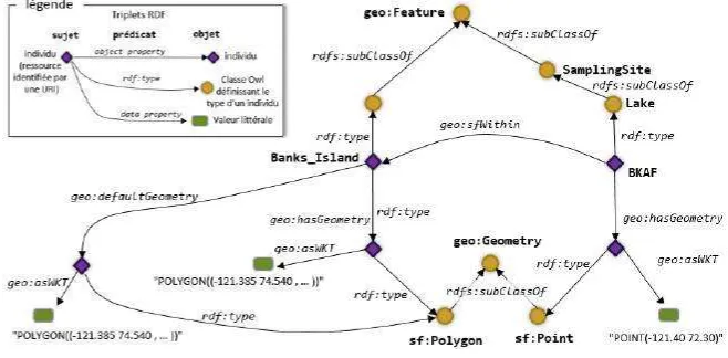
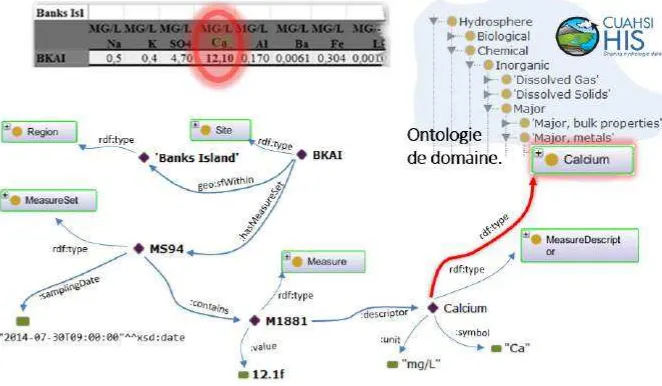
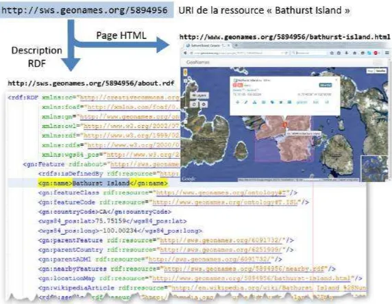
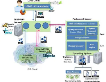
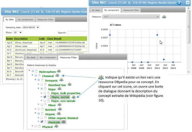
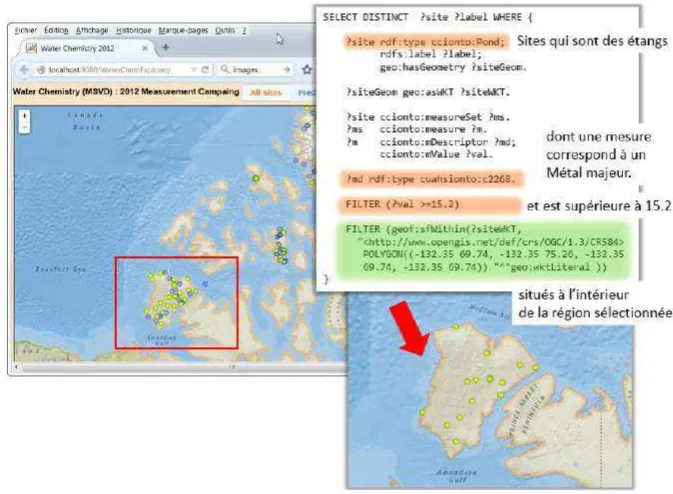
A third approach specializes on particular aspects and can be used to illustrate the concept and power of semantic annotations based on well-defined ontolo-gies. The concept, illustrated here with some example tools, query languages and runtime environments, would allow for enhanced searches for associations within an SDI for the Arctic. The ontology driven approach is only introduced here briefly. For more details, please be referred to AppendixE.
FIGURE 5.6: Ontology and triple store based approach, source:
Chapter 5. Architecture 47
This approach allows to visualize associations between stakeholders, data, and processing services, which would allow valuable insights for other stakehold-ers with similar requirements, as they could consider copying or adapting work-flows executed by others.
5.2.4
Architecture Requirements
Independently on the chosen approach, a number of aspects have been repeat-edly identified as being relevant for a successful SDI. These are usually com-plemented with the standing request for openness as illustrated in figure 5.7. Openness usually refers a number of aspects that circle around the fact that an element is openly (in the sense of publicly and royalty free) available and re-usable, developed in an open process, accessible at minimum costs (in terms of data pure reproduction costs or even no costs).
FIGURE5.7: Aspects of openness
Chapter 5. Architecture 48
In addition to these general requirements (that are purely stated here, not judged, as we fully acknowledge that some data cannot not be openly available but needs to be protected to ensure privacy constraints), an ideal SDI architecture shall be designed to provide for:
• Registry and discovery
– rapidly discover and access information, products and data;
– Architecture shall support search mechanism that go beyond meta-data based key-word search, as metameta-data is never complete and often hard to maintain
– Auto-registry for sensors (both remote and in-situ)
– Search engine for finding and browsing data, services, and metadata. It should be adaptable to allow for basic quick searches through de-tailed searches using multiple criteria including: geography, time, organization, physical parameter.
– Non-mapped search results (e.g. technical reports, multimedia) should be associated with mapped search results and viewable in the web browser.
• New functionality and extension
– Easily publish/reference information, products and data into the SDI.
– Integrate new functionality;
– The vision for SDI deployment is to allow users to discover (search), view, assemble and obtain desired data and services for a particular area of interest without needing to know the details of how the data and services are stored and maintained by independent agencies, or-ganizations and data custodians.