PRMCffiffiMBruG
OF
INITERNATIONAL FEDERATION
OF
LANDSCAPE
ARCHITECT
ASIA
PACIFIC
REGION
CONFERENCE
Master
Plan of Togean Islands
Marine
Tourism
Qodarian Pramukanto
Department of Landscape
Architecture, Faculty
of
Agriculture,
Bogor
Agricultural
University
(IPB), Indonesia;
:
Setia Hadi
Department of Landscape
Architecture, Faculty
of
Agriculture,
Bo
gor
Agriaitural
Univers
ity
(l PB)
Center
For
Regionol
SystemAnalysis,
Planning,
and Development (CRESTPENT),
Bogor
Agricultural
University
(IPB), Indonesia
Abstract
Togean islands is one of major tourist destination
in
Tomini Bay, CentralSulawesi.
The area lies inthe hearth
of
global marine
biodiversity,so call
"coral
triangle."
The beoutiful seascape with smallgroup
of
islands,
and
underwaler
scenery with numerouscoral
reef, unique crealures,ofers
great spectacular dive sitefor
tourists.
Moreover, someendemic species of marine and terreslrial ecosystem
and ethnic group, such as Baja people lead the area
as the richest
tourislict.
Those nature and cultural diversityshould be
managedfor
sustainabilityof
tourism.
Thereforethe
masterplan
to guide
thedevelopment of marine tourism is needed.
The
research consists
of
preparation,
field
surveys,
analysis
and
interprelation
of
data,synthesis, and preparing mdster Plan
stages.
TheMasler
Plan
of
Morine Tourism was
developedbased
on
lhe
assessmenlof
aqualic,
terrestrial,cultural and feasibility
of
potential objecls
and marine tourismattraction
andformulaled
into
sixf;4orine Tourism Development Area (MTDA).
Keywords:
masterplan, marine tourism,
Togean islands, coral triangle.1. Introduction
Indonesia is an archipelago that is rich
in
diversenatural and cultural resources. Country
with
an areaof
marine watersby two{hirds
(3.650.000 km2)of
the region andl7
480 islandswith
long coastlineof
about 95 181 km is the potential for marine tourism.
Togean islands is one
of
major tourist destinationin Tomini
Bay, CentralSulawesi.
The area lies inthe
hearthof
global marine biodiversity, so
call "coral triangle," composed of Indonesia, Philippines,Malaysia, Papua New Guinea, Japan, and Australia.
It
is the only placein
the world where atoll, laguna,fringing reef, barier reef, and lagoon can be all found
together.
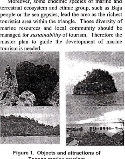
The beautiful seascape with small group of islands,
white sandy beaches, and underwater scenery with
numerous coral reef, wall, pinnacles, unique
creatures, coral garden offers great spectacular dive
site. Diving, snorkeling, fishing, sunbathing,
sight-seeing, nature tracks, roaming the village, are a
lead-ing activities of Togean islands marine tourism (Figure
l).
This tourist area is supported by diveresorts, cottages, bungalows, and other
accommodations.
Moreover, some endemic species
of
marine andterrestrial ecosystem and ethnic group, such as Baja
people or the sea gypsies, lead the area as the richest
touristict area within the
triangle.
Those diversityof
marine resourcesand
local
community should bemanaged for sustainabiliry of tourism. Therefore the
master
plan
to
guidethe
developmentof
marine [image:2.598.304.523.482.759.2]tourism is needed.
2.
Metodologi
The research was conducted at Togean Islands
of
Tojo
Una-Una Regency, Central Sulawesi province,for four months. This
research method consistsof
the
following
stages: Preparation,Field
surveys,Analysis and interpretation
of
data, Synthesis, andMaster PIan.
Preparation
phase performed desk studies
to preparethe
preliminary informationthat
includes:marine potency for tourism, preparation of base map,
thematic map, preparation of marine tourism resource
typology as the
basisin
preparing Analysis Unit.Field
survey conductedto
collect primary data andsecondary
data,
such
as
climate,
bathymetry,monographs, statistical data, annual reports and other
supporting information. Analysis of the potential for marine tourism carried out
by
assessing the aquatic,terrestrial,
cultural
and feasibility
of
objects
andattractions on every unit ofanalysis.
Base on objects and attractions of marine tourism
potential devevoped
a
masterplan.
Masterplan
isbased
on
the
conceptof
marine tourism
space(functions, activities and facilities)
that
will
bedeveloped.
Space concept
is a
fundamentalphilosophical
is
usedin
the
preparationof
spatialstructure in marine tourism development
plan-3.
Data Analysis
As the leading sectors, marine tourism Tojo Una_
Una distinguished by the orientation of tourism to the
aquatic and terrestrial areas. Aquatic area includes
waters that are influenced
by the
patternof
tides,waves and currents-
While
the terrestrial land areawhich is bounded by the waters in the direction of the
inland.
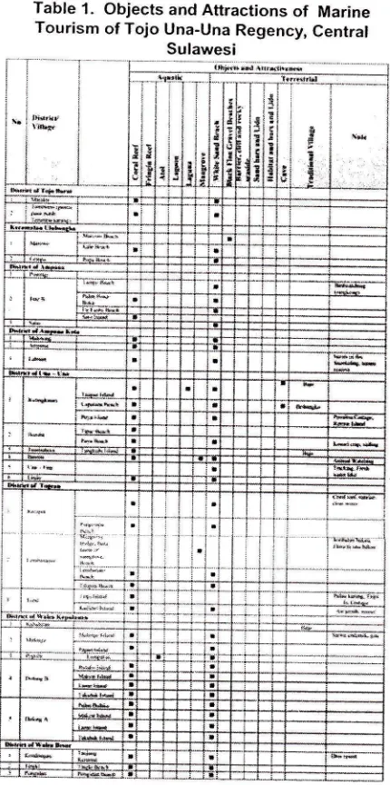
Details of the location of objects and marine tourism attraction is presented in Tablel.
3.1.
Spatial Analysis
Unit
Analysis
of
the
potentialfor
marinetourism
andtourist attractions are spatially done
on
theunit
of
analysis.This
unit
consistsof
bottom
depth, thepresence
of
shallow water,the
presenceof
small islands,coral reefs (barrier, fringing), atolls
and lagoons, Iagoon and mangrove vegetation existence.Dishidros bathymetric maps based on interpretation
of
1990 (scalel:
75
000),AMS
1957 bathymetricmap (scale
1:
250 000), and
barhymetric mapsMCRMP
2004 (scalel;
50
000) can delineate thespace into 47 analysis units (Table 2 and Figure 2) .
Table
1.
Objects and Attractionsof
Marine Tourism of Tojo Una-Una Regency, Central [image:3.601.303.518.102.534.2]r"r'i-i;
-i"d-r. ")"' *:--'_Y''-.--: _ "!-I ; !* j
-.j... i.. ..: I-: 9_.1:111i|1ll]$tt.l..i,:-.i..: *-i'--i --i-: ,ti
-i i
iIL
16 I id.
Table
2.
Spatial Analysis Unit of Tojo Una-Una Regency, Central SulawesiTable 3.
2I. (rhrlns
3t. aortirna,(
35.
t I
POTEiiCY OF lvlARlNE TClLretM )A1EX qS U' ffi Iffi ${ 1S lNr3 slils.
r.APOFANALYSIS UNIT
E
,..,* ',."^
.-'-"*
,.*"Figure
2.
Map of Spasiat Analysis Unit of Tojo Una-Una Regency, Central Sulawesi3.2.
Assessment
of
Potential Objects
and
Attraction
of
Marine Tourism
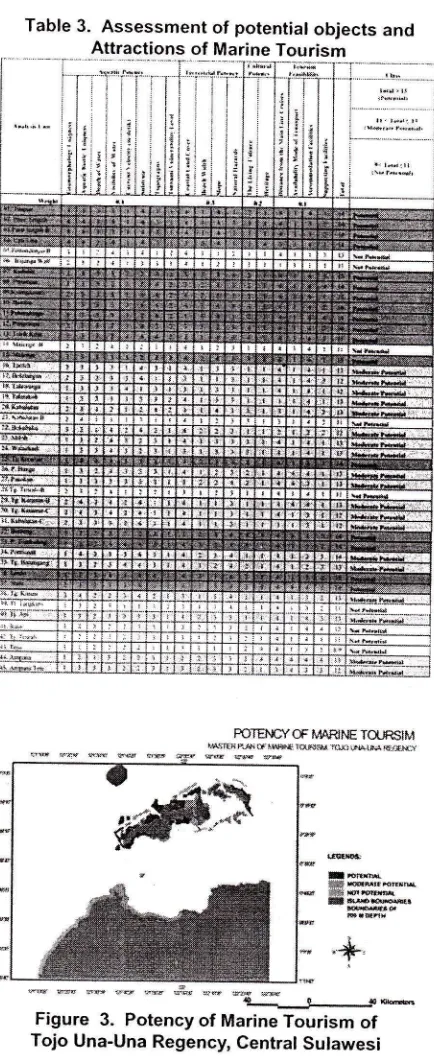
Analysis performed on marine tourism potential
of
each
unit
of
analysisis
basedon
the criteria of
aquatic, terrestrial and feasibility of potential objectsand marine tourism attraction. Tabulation
of
theresults
of
potential
assessmetof
objects
andattraction is presented in Table 3 and Figure 3.
fBie ffirex*ffi.H mg'sr@t
"*.
** **
"a'"**
*,ffi_.r--.*
Figure
3.
Potency of Marine Tourismof
Tojo Una-Una Regency, Central Sutawesi
4.
Master
PIan
Marine Tourism
In
the developmentof
marine tourismin
Togeanislands,
Tojo
Una-Una, the conceptof
the proposeddevelopment are:
(1.)
Improving thequality
of
theobject
and
marine tourism
attraction
throughimproved
facilities,
infrastructure,
institutional,human resources and promotion, (2.) preservation
of
aquatic
conservationarea
a
type
of
coral
reefs(barrier reef, fringing reef, lagoon, atolls and lagoons,
[image:4.612.65.288.66.684.2] [image:4.612.316.533.81.613.2]species,
such
as
tarsiers),
living
culture
andpreservation
of
cultural communities such as Bajo,Bongbongko,
Bugis and
Gorontalo
and
(3.) integrated developmentof
tourist activity and
theactivity
of
mariculture, seaweed cultivation, culturedpearls as objects and attractions.
Delineation
of
the nrarine tourism development isbased
on
the
following criteria,
namely:
( I .)Uniformity of object types and intrinsic character and
tourist appeal, (2.) The location
ofthe
access patternsof common objects and marine tourism attraction, (3)
the proximity
of
marine attractionswith
the servicecenters,
and
(4)
the
proximity
of
the
object distribution and attractions, geographically. Based onthese
delineation
criteria
can
be
developedregionalzaion
based
on
physiographic
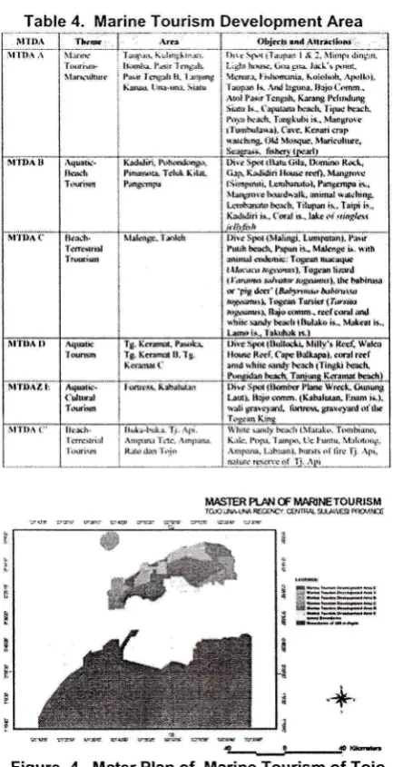
unit, ecological and geographical.Spatial arrangement of the Master PIan
of
MarineTourism
can
be
formulatedinto
6
(six)
Marine Tourism Development Areas(MTDA)
that carries aspecific theme, namely:
l.
MTDA
A with
the theme"Aquatic
-Mariculture
Tourism",
2.
MTDA
B with the theme "Aquatic -Beach Tourism",3. MTDA
Cwith the
theme
"Beach-TerrestrialTourism",
4.MTDA
D
with
the
theme"Aquatic Tourism",
5.MTDA
E with the theme "Aquatic-Cultural Tourism", andMTDA
C'
with
the
theme "Beach-Terrestrial Tourism".In
detail, the
theme, scope,object
andmarine tourism attraction is presented in Table 4. and
Figure 4.
5.
Remarks
Master
Plan
of
Togean IslandMarine
Tourism was developed baseon
assessmentof
the potentialaquatic, terrestrial cultural and tourism feasibility.
Marine tourism develpoment.
The
spatial arrangementof
the
MasterPlan
of
Marine Tourism
can
be
formulatedinto
6
(six) Marine Tourism Development Areas(MTDA)
thatcarries a specific theme, namely:
l.
MTDA
A
withthe
theme "Aquatic -Mariculture Tourism
",
2.MTDA
B with the theme "Aquatic -Beach Tourism",3.
MTDA
C
with
the
theme
"Beach-TerrestrialReferences
[]
Allen, G.R., and M. Adrim. Coral Reef Fishesof
Indonesia. Zoological Studies a2$): I - 7 2. 2003.
[2] Allen, G. R., and S. A. McKenna (eds.). A Marine
Rapid Assessment of the Togean and Banggai Islands,
Sulawesi, Indonesia. RAP Bulletin of Biological
Assessment 20, Conservation International,
Washington, DC. 2001.
[3] Desaunettes, J.R. Catalogueof of Landform for
Indonesia. Land Capability Apprasial Project, Soil Res.
Inst., Bogor. I I
lp.
1977.[4] Dietvorst,
A.
Changing Planning Strategies forRecreation and Tourism Ducth Experiences. Coucil for
Tourism",
4.
MTDA rvith the
themeTourism",
5. MTDA
E
with the
themeCultural Tourism", and
MTDA
C'
with " Beach-Terrestrial Tourisrn"."Aquatic
"Aquatic-the theme
MASIER PI.A',I OF IiiAR'I{ETOURISM
r@s&rs@a- €iR 9&G l&as
* t
.+
s x s tt
'
#k*l)l!!'+*.*r &:****t r.*b.d-. .L-_.,}-.JptuFigure
4.
Mater Planof
Marine Tourism of Tojo Una-Una Regency, Central SulawesiEducator in Landscape Architecture (CELA)
Conference, Denver. I 990.
[5J Dinas Kebudayaan dan Pariwisata. Profil Peluang
dan Potensi Investasi
Kabupaten
Tojo Una-UnaTahun 2010. Dinas Kebudayaan dan Pariwisata,
Kabupaten Tojo Una-Una. 201 0.
[6]
FAO.
Marine Conservation Potential Togian Islands,Central Sulawesi. UNDP/FAO National Park
Development Project. 1982.
[7] ReefBase. http://www.reelbase.org/gis*maps/
datasets.aspx
[8] Smith, R. Pygmy species explotions. Sport Diving
Magazine, (Febmary/ March). 2010.
Table
4.
Marine Tourism Development Area;u rD;\
liffi..i.i-
ii;;*-
tLem %;iij;; (;i;;;;:ti;;;ri.*
linlx- I'.{r 'f(ryrr
Prrir I e8lh t. 1 :x..t!rts
XiBr lie{m- iial!
ol'j*R tnd A{rfdi{tr':.
i,;i; :.i;; ai;;;;;l f l.
ii*ili';tn'
i,;iiln )xw.{;r:5F)L l*l'r tx!(r.
lleB{ liilwnia. Ldidif ..{Frl*}i, 'FolM ti
^rd
lslet. lrrjo (:.sn' .\,$l PGr f.f*sh. Krel*' }.hffdul{i
Sit{s k.. eryw }cel\ litxc lE$L lhlr tx&*. *r8lubi ir.. UstrBxr iiqbulBrrl. Ca*. XcBi cHrt
**.trrE- i']ld lkBtw. ,,si.rltre,
5t'n)a Il
lldh Pirwrlb Ttl!tr li;lrt.
Pmgsrix
ufd )F1t itHu t!tsr uma Rs! ft!\ Xrdidi.i l}N N0. !rld'*s*
lsirpinni. lribd0l, Peg@p. ir,
llili$lr. lxud\all. eidHl *d.bisri
Lsdls* bcBi,'l il4s i{, lnipi ir,,
Kiirdiri ii. Cmt B, h&c fi Il)x/ar
'IIlr ( th3 l*h 5p{ b6d! (y&rrtr. LwlHlilr- Psclh$in iL M.kr# ir. $ttlt
&im*l oklcoie: Iogffi r6eSc
t,lrixuB raSuer). logtr $@d
l.Yardtus hltw b8@lr*r. $n habiN
s 'piE i&tr' (raarjfrse }rftuM
n*.:@rl Tres Tsis {fPrrb
tXffiI &{[slm- r*t.0al &,
sni* snly bceh t&ulat} ii.. Y*e i5.
I r6ni. hG&rL * r
TgKffi*lr,'ls XtlWU
rrE-xxarurle iltrr] r ,ffi, E.Et
llle 8el- (qe tsoll.F.l, .f,l re,
$d srrie $dy tr*h iIi$Xki t{e<r!
SIDAZ I
(dnB, iIffiq}i$.l*r txrr 136l Sr*t ,lqs t8ffib6?!sE $m. tl&b.re frs $d*. Crse*irL nlli Bdrf)xd.,ffi pste$rd d ** ltr ! *uti{r{t{ t. {te.
: .r:oaer'trrr. lmp*u
i nrr, *ae-r'1r
\Yh{. *xl} k} i\lsbtr, Tr*rha,h.
[image:5.599.302.519.141.564.2]