QUALITY ASSESSMENT OF BUILDING TEXTURES EXTRACTED FROM OBLIQUE
AIRBORNE THERMAL IMAGERY
D. Iwaszczuka,∗, U. Stillab
a
Astronomical and Physical Geodesy, Technical University of Munich, Arcisstr. 21, 80333 M¨unchen, Germany [email protected]
b
Photogrammetry and Remote Sensing, Technical University of Munich, Arcisstr. 21, 80333 M¨unchen, Germany - [email protected]
Commission I, WG I/2
KEY WORDS:Quality, Textures, 3D, Mapping, Line, Matching, Thermal, Infrared
ABSTRACT:
Thermal properties of the building hull became an important topic of the last decade. Combining the thermal data with building models makes it possible to analyze thermal data in a 3D scene. In this paper we combine thermal images with 3D building models by texture mapping. We present a method for texture extraction from oblique airborne thermal infrared images. We put emphasis on quality assessment of these textures and evaluation of their usability for thermal inspections. The quality measures used for assessment are divided to resolution, occlusion and matching quality.
1. INTRODUCTION 1.1 Motivation
Urban areas and buildings are one of the most important sub-jects being investigated using photogrammetric and remote sens-ing methods. Often, images taken from a flysens-ing platform are used for such purposes. Oblique airborne images taken from different direction make it possible to map the building hull on 3D data, such as point clouds (H¨ohle, 2014) or 3D building models (Fr¨uh et al., 2004). Such textured 3D data can be used to investigate di-verse properties of buildings and phenomena. Visible images are used facade reconstruction (Ripperda and Brenner, 2006), dam-age assessment (Kerle et al., 2014). Using a thermal camera, the energy efficiency of buildings can be assessed and heat leakages can be detected (Hoegner et al., 2007, Borrmann et al., 2012, Westfeld et al., 2015).
In the recent years there have been many research projects con-centrating on thermal properties and heat losses in (Meng and Stilla, 2007, Fondazione Bruno Kessler, 2014). Mobile Mapping Systems may be used to quickly acquire thermal data for entire districts (Hoegner et al., 2007) or cities (Chandler, 2011). Ther-mal data can be combined with a point cloud. Such method was presented for an indoor application (ThermalMapper, 2013). A laser scanner and a thermal camera are mounted on a robot for mobile mapping of building interiors. Thermal information is mapped on the acquired point cloud. In another research project, the Automated Rapid Thermal Imaging Systems Technology (ARTIST) was developed to quickly identify inefficient buildings by detect-ing heat losses through walls, roofs, doors and windows (Phan, 2012). Thermal data collected in urban areas can be also used for an online system with an open access. HEAT (Heat Energy Assessment Technologies), a GeoWeb service, is provided in Cal-gary, which can be used by house owners to view their building quality, or by maintenance companies to verify building quality and to monitoring over space and time (HEAT, 2013). This sys-tem stores thermal images of building roofs together with address information and detected hot spots. The cost per day of heating the home and CO2emission are estimated based on the thermal
∗Corresponding author
data that was acquired with a thermal pushbroom scanner TABI-320 delivering stripes TABI-320 pixels wide. A similar system is avail-able for the island Jersey in the Channel Islands (States of Jersey, 2013).
The thermal images can be combined with 3D building models via texture mapping. Due to narrow streets in urban areas, ac-quiring the data from a terrestrial platform requires relative ori-entation, matching with the 3D building models using a gener-ated point cloud and automatic mosaicing of oblique image se-quences in order to create high resolution thermal textures (Hoeg-ner, 2014). By mounting the thermal camera on a flying platform, the resolution of extracted textures is usually lower, but it helps to avoid artifacts in the textures which are result of mosaicing. Besides, from the bird’s eye view the roofs and facades in inner yards, which are not visible from the street view, can be captured.
1.2 Related work
Texture mapping on 3D models is a widely used technique, es-pecially in computer graphics, and results in adding an image to the existing 3D geometry. Photorealistic (Weinhaus and Devara-jan, 1997, Allen et al., 2001) and non-photorealistic (Klein et al., 2000) textures, however, can be distinguished. For photorealis-tic texturing, the assignment of the images of a real scene to the corresponding 3D model has to be accomplished.
Texture extraction has already been implemented in several com-mercial software and imaging systems. One of such systems, Semi-Automated Modeling and Texturing System (SAMATS), was presented by (Hegarty and Carswell, 2009). This system produces textured building models from a set of geo-referenced terrestrial images. Similarly, the systemToposcopy(Groneman, 2004) has been developed to create photorealistic 3D models. It uses photogrammetric methods for linking a 2D map to ter-restrial images. (Grenzd¨orffer et al., 2008) use MultiVision, a commercial software, to texture the created 3D models semi-automatically.
(Pelagotti et al., 2009), or infrared images (Hoegner and Stilla, 2007, Iwaszczuk et al., 2012). In principle, it is also possible to combine 3D building models with Synthetic Aperture Radar (SAR) images as long as shadow and layover effects are consid-ered (G¨otz, 2010).
Various imaging systems have been applied for texture mapping. (Wang et al., 2008) used the systemPictometryfor this purpose. This system consists of five cameras with one nadir-looking cam-era and four oblique looking camcam-eras which are mounted on a flying platform. This system found a variety of applications in-cluding urban planing, 3D modeling, and emergency response (Karbo and Schroth, 2009). The system PFIFF (Grenzd¨orffer et al., 2008) is also based on an oblique looking camera, which is integrated with a GPS receiver. Oblique view geometry require special treatment for flight planning (Grenzd¨orffer et al., 2008) or measurements (H¨ohle, 2008). Texture mapping is also possi-ble using a push-broom instrument. (Lorenz and D¨ollner, 2006b) textured 3D building models using High Resolution Stereo Cam-era (HRSC) mounted on an aircraft.
In most studies, the texture quality was introduced as a value used to select the best texture. Such quality calculated for the selection procedure can be stored with the texture. It is an abstract value, however, which can be interpreted to compare the quality be-tween faces, but does not give information any about the level of detail of the texture and its fit to the 3D model. Some researchers, therefore, calculate local resolution for every pixel. (Lorenz and D¨ollner, 2006a) analyzed the quality of texture extracted from airborne images taken with an HRSC camera and created qual-ity maps consisting of local effective resolution. Similar resolu-tion maps for textures are also presented in (Hoegner and Stilla, 2007). (Hoegner et al., 2012) assess the matching quality be-tween the image sequence and the building model by analyzing the extracted textures. Textures from different sequences at dif-ferent times and with difdif-ferent orientation parameters are com-pared through correlation and assessed visually. This method does not give any independent measure that could express the quality of fit between the model and the extracted texture.
1.3 Paper Overview
In this paper we present a method for texture extraction from oblique airborne thermal infrared images which is described in Section 2.. We put emphasis on quality assessment of these tex-tures and evaluation of their usability for thermal inspections. The quality measures used for assessment are divided to reso-lution, occlusion and matching quality and are presented in Sec-tion 3.. Experimental results are presented in SecSec-tion 5. and dis-cussed in Section 6..
2. TEXTURE EXTRACTION
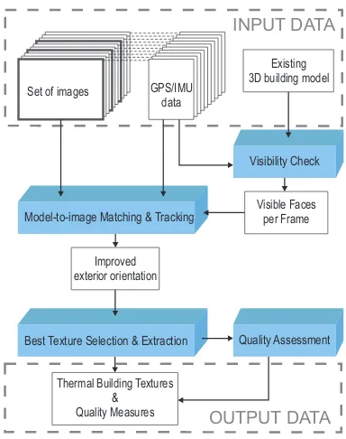
Textures are extracted from thermal images based on the 3D model projection. This procedure is schematically presented in Fig. 1. The 3D building model is projected into the image based on ini-tial exterior orientation given by the camera calibration and nav-igation data. First, the visibility is checked in order to select the visible faces of the model for each frame.
Then, a model-to-image matching is carried out inkey-frames. Applied matching is a line based matching and is supported by tracking lines between the frames. As result of the matching pro-cedure, corrected exterior orientation parameters for every frame are calculated. This method is described in detail in Anonymous (2014).
INPUT DATA
Quality Assessment Set of images
Best Texture Selection & Extraction
Visibility Check Existing 3D building model
Improved exterior orientation
GPS/IMU data
Model-to-image Matching & Tracking
Thermal Building Textures &
Quality Measures OUTPUT DATA Visible Faces
per Frame
Figure 1: Extraction of thermal textures
In the next step, thermal textures are extracted. Typically, build-ings or building complexes need to be captured from multiple views in order to gain textures for all faces. Often, thermal im-ages are taken in a sequence. Because of it, some faces may appear in many frames. Therefore, a best texture selection proce-dure is implemented. This proceproce-dure is based on a general texture quality results calculated based on distance, occlusion and view-ing angle. This results in one-to-one assignments between the faces and images. This procedure is described in more detail in Anonymous, 2010.
3. TEXTURE QUALITIES 3.1 Resolution
The texture’s level of detail depends on its resolution. The reso-lution of 3D objects seen on the image plane is usually not unique along their surfaces. Unique resolution is possible only for pla-nar objects that are parallel to the image plane. In nadir view photogrammetry, the ground resolution of the images is usually expressed using a ground sample distance (GDS), which is the distance between the pixel centers on the ground. It is calculated using the intercept theorem:
ck
s′ = H
s, (1)
be calculated: inx- and iny-direction of the camera coordinate system.
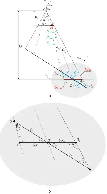
An oblique view is equivalent to a nadir view of a sloped surface. This representation is suitable not only for the ground surfaces but also for other surfaces, e.g. fac¸ades or roofs. In this represen-tation, a planar surface can be defined for each pixel. This surface is parallel to the sensor and intersects with the photographed sur-face in the intersection point of the ray from the middle of the pixel with the photographed surface (Fig. 2a).
x
Figure 2: Detailed geometry for calculations of the resolution
If the distanceDi, which is the distance from the projection cen-ter to the photographed surface is known, the resolution of this parallel surface can be easily calculated using (1) by replacingH
withDi, which results in
Here, the indexidenotes the pixel; however, in many cases, the photographed object is rotated by an angle
γi= arccos(
−→
−z◦ −→n
k−→zkk−→nk), (3)
where−→n is the normal vector of the photographed surface and
−
→z = [0,0,1]. For everyγ
i >0, the length of the line segment on the photographed object isli> si. The ray from middle of the pixel does not intersect the line segment on the photographed ob-ject in the middle of this segment, but instead divides this segment into two line segments with the lengthsli−1andli−2respectively (Fig. 2b). To calculateli, the triangles∆A1B1Pand∆A2B2P should be solved. Using the Law of Sines,li−1is calculated from
∆A1B1P
φiis calculated by solving the triangle∆OO′P′as follows
tanφi= ri can be simplified to
li=si
Another simplification is presented in Fig. 3. Hereliis length of the line segment, which has to be orthogonally projected onto the surface parallel to the sensor to fill one pixel
li=
Figure 3: Simplified geometry for calculations of the resolution
The resolution is calculated for every pixel in x- and in y-direction. This resolution is stored in form ofresolution maps. The reso-lution mapsare textures of the same size as the corresponding thermal texture and store the x- and y-resolution for each of the texture.
3.1.1 Occlusion In general, it can be distinguish between self-occlusions and extrinsic self-occlusions. Self-occlusiosn is the occlu-sion of some faces of the 3D model by other faces and is cal-culated based on the 3D model acquisition geometry. Extrinsic occlusions is the occlusion of model faces by objects which are not modeled in the 3D model, such as cars, pedestrians, or trees if they are not included in the 3D model. The extrinsic occlusions are typically detected from multiple views (B¨ohm, 2004) or from additional data (B´enitez et al., 2010).
The self-occlusions can be permanent or temporal. Permanent occlusions occur independently on the viewing direction, for ex-ample between two touching buildings. Temporal self-occlusions depend on the viewing direction of the camera and can change from frame to frame (Anonymous, 2010). These occlusions are treated separately and stored together with the textures as occlu-sion maps.
The occlusion is also expressed as a single quality measure per face per frame. It gives information about which percentage of the texture can be seen in a frame. The occlusion factoroij is defined as
oij= nvis
N , (12)
wherenvisis the number of visible pixels in face,jin framei andN is the number of pixels occupied by facej. The quality
oij∈[0,1]takes valueoij= 1for fully visible textures.
3.2 Matching Quality
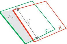
Matching quality is introduced to measure how precisely the model was projected onto the image and how accurate the model is it-self. Inaccuracies in data acquisition, the creation process, or the generalization can result in a faulty model. The matching quality of a texturetijassigned to facepjin framefiis calculated using
νtij =
v u u u u t
Kj
X
k=1
Aijk
lijkIM
2
Kj
, (13)
whereAijk denotes the area between the projected model line segment and the actual corresponding line segment in the image,
lijkIM denotes length of the projected model line segment,Kj
denotes number of sides in the face polygonpj(Fig. 4).
Aijk l ijk
pj pj
IM
ref
Figure 4: Calculation of matching quality
The actual corresponding line can be measured in the image by a human operator, or it can be estimated using the intensity values surrounding the projected model line segment in the image. To
evaluate the texture extraction in a framefi, a quality measure
νfi=
J
X
j=1
νtij
J (14)
is used. To assess the matching quality for a facepjamong all frames
νpj =
I
X
i=1
νtij
I (15)
is calculated. Combining (14) and (15), the matching qualityνof the whole matching process is computed as
ν=
I
X
i=1 J
X
j=1
(νT ij)
I·J . (16)
In (14) - (16)Jdenotes the number of visible faces in a framefi, andIdenotes the number of frames.
4. DATA DESCRIPTION
In order to capture all of the fac¸ades and roofs in the test area, an appropriate flight campaign was designed and conducted. During this flight campaign, the helicopter flew four times above the test area, recording a sequence of oblique TIR images. As a result, four crossing stripes where captured. This flight campaign took place in autumn in the early afternoon. The test area is a densely built-up downtown area, where the buildings create ring-shaped structures with inner yards.
The thermal images were taken with TIR camera AIM 640 QLW FLIR with a frame rate of 25 images per second, which was mounted on a platform carried by helicopter. The flying height was approximately400[m] above the ground level. The camera was forward looking with an oblique view of approximately45◦. The size of the chip was640x512[pix2]. The helicopter flew over the test area four times, recording four strips of IR image sequences. Each strip consists of almost130frames.
5. RESULTS
For each face of the model, a TIR texture was created. Those textures were mapped on the 3D geometry inCityGMLformat and displayed usingAutodesk LandXplorer(Fig. 5).
Figure 5: 3D building model with TIR textures
Table 1: Quality measureν calculated after system calibration and after matching in every frame
ν[pix] ν[pix]
after system calibration after matching in every frame
4.74 1.48
manually in 70 frames. These reference polygons were used to calculate the quality measureνfrom (16) with and without line tracking.
First, the quality measure was computed for the initial model pro-jection using the exterior orientation parameters after system cal-ibration. Then, the quality measureνwas calculated for projec-tion using the exterior orientaprojec-tion parameters corrected by match-ing. These results are presented in Tab. 1. The quality measure
νwas also calculated after tracking. These results are presented in Fig. 6. This experiment was carried out for varyingkey-frame
intervals.
Figure 6: Quality measureνcalculated after tracking with vary-ingkey-frameinterval
6. DISCUSSION
The introduced quality measures allow to evaluate single textures and whole process of texturing.
In this paper, matching quality was used to evaluate the usability of tracking as mean to speed up the matching procedure without loosing accuracy. By tracking the line segments assigned to the 3D model from frame to frame, the search area is restricted, and the time needed for calculation is reduced.
Analysis of the matching quality showed that tracking is suffi-cient for finding the line correspondences needed for camera pose estimation.
REFERENCES
Abdelhafiz, A. and Niemeier, W., 2009. Integration of digital images and laser scanning point clouds - texture mapping with 3dimage. Journal of DVW 60, pp. 113–125. 91. DVW-Seminar Terrestrial laser scanning TLS2009 Fulda, Germany, November 19-2.
Allen, P., Stamos, I., Gueorguiev, A., Gold, E. and Blaer, P., 2001. Avenue: Automated site modeling in urban environments. In: Proceedings of Third International Conference on 3-D Digital Imaging and Modeling, pp. 357–364.
B´enitez, S., Denis, E. and Baillard, C., 2010. Automatic pro-duction of occlusion-free rectified fac¸ade textures using vehicle-based imagery. In: ISPRS International Archives of Photogram-metry, Remote Sensing and Spatial Geoinformation Sciences, Vol. 38-3A, pp. 275–280. Proceedings of PCV 2010 - Photogram-metric Computer Vision and Image Analysis.
B¨ohm, J., 2004. Multi-image fusion for occlusion-free fac¸ade texturing. In: ISPRS International Archives of Photogramme-try, Remote Sensing and Spatial Information Sciences, Vol. 35-B5, pp. 867–872. Proceedings of XX ISPRS Congress, Istanbul, Turkey.
Borrmann, D., Elseberg, J. and N¨uchter, A., 2012. Thermal 3d mapping of building fac¸ades. In: Proceedings of the 8th Confer-ence on Intelligent Autonomous Systems. Jeju Island, Korea.
Chandler, D., 2011. The big picture on energy loss.
MIT news http://web.mit.edu/newsoffice/2011/
ir-scanning-energy-0316.html. Access on July 30th, 2012.
Fondazione Bruno Kessler, 2014. Non-active project at 3dom - 3d optical metrology unit: Ir3d (2008-2009). Online: http: //3dom.fbk.eu/en/node/89. Access on June 5th, 2014.
Fr¨uh, C., Sammon, R. and Zakhor, A., 2004. Automated tex-ture mapping of 3d city models with oblique aerial imagery. In: Proceedings of the 2ndInternational Symposium on 3D Data Pro-cessing, Visualization, and Transmission (3DPVT’04).
G¨otz, C., 2010. Bestimmung der layover-bereiche bei der sar-abbildung von geb¨audemodellen. Master’s thesis, Fachgebiet Photogrammatry and Remote Sensing, Technische Universit¨at M¨unchen.
Grenzd¨orffer, G., Guretzki, M. and Friedlander, I., 2008. Pho-togrammetric image acquisition and image analysis of oblique imagery. The Photogrammetric Record 23(124), pp. 372–386.
Groneman, A., 2004. Toposcopy combines photogrammetric modelling with automatic texture mapping. In: ISPRS Interna-tional Archives of Photogrammetry, Remote Sensing and Spatial Geoinformation Sciences, Vol. 34-5/W12, pp. 168–172. Proceed-ings of the ISPRS workshop on Vision techniques applied to the Rehabilitation of City Centres held in Lisbon, Portugal.
HEAT, 2013. Geoweb service heat. Online: http://www. saveheat.co/. Access on June 17th, 2013.
Hegarty, J. and Carswell, J., 2009. Samats - texture extraction explained. In: ISPRS International Archives of Photogrammetry, Remote Sensing and Spatial Geoinformation Sciences, Vol. 38-5/W1. Proceedings of 3D-ARCH 09 - 3D Virtual Reconstruction and Visualization of Complex Architectures, Trento, Italy.
Hoegner, L., 2014. Automatische Texturierung von Gebudemod-ellen aus terrestrischen IR-Bildfolgen. PhD thesis, Fachgebiet Photogrammetrie und Fernerkundung, Ingenieurfakultt fr Bau Geo Umwelt, Technische Universitt Mnchen.
Hoegner, L. and Stilla, U., 2007. Texture extraction for building models from ir sequences of urban areas. In: Proceedings of JURSE 2007 - Urban Remote Sensing Joint Event, pp. 1–6.
Hoegner, L., Iwaszczuk, D. and Stilla, U., 2012. Quality assess-ment for building textures from infrared image sequences. In: IS-PRS International Archives of Photogrammetry, Remote Sensing and Spatial Geoinformation Sciences, Vol. 39-B3, pp. 391–396. Proceedings of XXII ISPRS Congress, Melbourne, Australia.
Hoegner, L., Kumke, H., Meng, L. and Stilla, U., 2007. Auto-matic extraction of textures from infrared image sequences and database integration for 3d building models. PFG Photogramme-trie Fernerkundung Geoinformation 2007(6), pp. 459–468.
H¨ohle, J., 2008. Photogrammetric measurements in oblique aerial images. PFG Photogrammetrie Fernerkundung Geoinformation 2008(1), pp. 7–14.
Hsu, S., Samarasekera, S., Kumar, R. and Sawhney, H., 2000. Pose estimation, model refinement, and enhanced visualization using video. In: Proceedings of Computer Vision and Pattern Recognition, Vol. I, pp. 488–495.
Iwaszczuk, D., Hoegner, L., Schmitt, M. and Stilla, U., 2012. Line based matching of uncertain 3d building models with ir im-age sequences for precise texture extraction. PFG Photogramme-trie Fernerkundung Geoinformation 2012(5), pp. 511–521.
Karbo, N. and Schroth, R., 2009. Oblique aerial photography: A status review. In: D. Fritsch (ed.), Proceedings of Photogrammet-ric Week 2009, Wichmann Verlag, Heidelberg, pp. 119–125.
Kerle, N., Fernandez Galarreta, J. and Gerke, M., 2014. Urban structural damage assessment with oblique uav imagery, object-based image analysis and semantic reasoning. In: Proceedings of 35th Asian conference on remote sensing, 27-31 October 2014, Nay Pyi Taw, Myanmar. 6 p.
Klein, A. W., Li, W., Kazhdan, M. M., Corrˆea, W. T., Finkel-stein, A. and Funkhouser, T. A., 2000. Non-photorealistic virtual environments. In: Proceedings of the 27thAnnual Conference on Computer Graphics and Interactive Techniques, SIGGRAPH ’00, ACM Press/Addison-Wesley Publishing Co., New York, NY, USA, pp. 527–534.
Lorenz, H. and D¨ollner, J., 2006a. Fac¸ade texture quality estiama-tion for aerial photography in 3d city models. In: Proceedings of the Meeting of the ICA Commission on Visualization and Virtual Environments.
Lorenz, H. and D¨ollner, J., 2006b. Towards automating the gen-eration of fac¸ade textures of virtual city models. In: ISPRS Inter-national Archives of the Photogrammetry, Remote Sensing and Spatial Information Sciences, Vol. 36 part2. Proceedings of IS-PRS Commission II, WG II/5 Workshop, Vienna, on CD.
Meng, L. and Stilla, U., 2007. Enrichment and multi-purpose vi-sualization of building models with emphasis on thermal infrared data. Online: http://gepris.dfg.de/gepris/projekt/ 62030942. DFG project. Access on October 2nd, 2015.
Pelagotti, A., Del Mastio, A., Uccheddu, F. and F., R., 2009. Au-tomated multispectral texture mapping of 3d models. In: Pro-ceedings of 17th European Signal Processing Conference (EU-SIPCO 2009), Glasgow, Scotland, pp. 1215–1219.
Phan, L. N., 2012. Automated rapid thermal imaging systems technology. PhD thesis, Department of Mechanical Engineering, Massachusetts Institute of Technology. Institute Archives - Non-circulating Collection 3 — Thesis M.E. 2012 Ph.D.
Ripperda, N. and Brenner, C., 2006. Data driven rule proposal for grammar based fac¸ade reconstruction. In: Pattern Recognition. Proceedings of 28thDAGM Symposium, pp. 750–759.
States of Jersey, 2013. Jersey heat loss map. Online: http: //gis.digimap.je/jerseyheatlossmap/. Access on June 25th, 2013.
ThermalMapper, 2013. Project webpage. Online: http: //www.faculty.jacobs-university.de/anuechter/ thermalmapper.html. Access on June 17th, 2013.
Wang, Y., Schultz, S. and Guiuffrida, F., 2008. Pictometry’s proprietary airborne digital imaging system and its application in 3d city modelling. In: ISPRS International Archives of the Photogrammetry, Remote Sensing and Spatial Information Sci-ences, Vol. 37-B1, pp. 1065–1066. Proceedings of XXI ISPRS Congress, Commission I, Beijing, China.
Weinhaus, F. M. and Devarajan, V., 1997. Texture mapping 3d models of real-world scenes. ACM Comput. Surv. 29(4), pp. 325–365.