ADVANCING THE DOCUMENTATION OF BURIED ARCHAEOLOGICAL
LANDSCAPES
W. Neubauer1,2, M. Doneus2,3,1, I. Trinks1
1
Ludwig Boltzmann Institute for Archaeological Prospection and Virtual Archaeology, Hohe Warte 38, A-1190-Vienna, Austria. 2 VIAS – Vienna Institute for Archaeological Science, University of Vienna, Franz Klein-Gasse 1/V, A-1190-Vienna, Austria. 3
UFG – Institute for Prehistoric and Medieval Archaeology, University of Vienna, Franz Klein-Gasse 1/III, A-1190-Vienna, Austria.
CIPA, ICOMOS and WG V/2
KEY WORDS: Archaeology, Aerial Archaeology, LiDAR, Ground Penetrating Radar, magnetometry, hyperspectral imaging spectroscopy
ABSTRACT:
The future demands on professional archaeological prospection will be its ability to cover large areas in a time and cost efficient manner with very high spatial resolution and accuracy. The objective of the 2010 in Vienna established Ludwig Boltzmann Institute for Archaeological Prospection and Virtual Archaeology, in collaboration with its nine European partner organisations, is the advancement of the state-of-the-art. This goal will be achieved by focusing on the development of remote sensing, geophysical prospection and virtual reality applications. Main focus will be placed on novel integrated interpretation approaches combining cutting-edge near-surface prospection methods with advanced computer science.
1. INTRODUCTION
Over the past decades landscape archaeology has increasingly gained importance. Despite a vast variety of approaches, a tacit agreement consists in the fact that landscape archaeologists are investigating beyond the individual site, dealing with space at different scales. This has led many archaeologists, but also preservationists, to enlarge their field of endeavour from individual sites towards entire archaeological landscapes. In order to be able to protect archaeological landscapes, these have to be identified and documented, which for various reasons presents an archaeological challenge: The massive threat of destruction and deterioration of buried cultural heritage demands for fast, efficient and reliable methods for its identification, documentation and interpretation. At the same time, the European Convention on the Protection of the Archaeological Heritage (Valletta-Convention) states that non-destructive investigation methods should be applied wherever possible (ETS N143, article 3).
Therefore, large-scale applications of non-invasive archaeological prospection methods (e.g. aerial archaeology, airborne laser scanning (ALS) and all kinds of near-surface geophysical prospection) comprise a great potential. These methods offer the most appropriate solution in order to provide both landscape archaeologists and planning authorities with the necessary spatial information at multiple scales, ranging from the archaeological site to a complete archaeological landscape. However, scientific archaeological prospection requires the implementation and adherence to the highest technical standards in regard to instrumentation, spatial sampling intervals, positioning accuracy, data processing and visualization, as well as appropriate novel methodological concepts for the archaeological interpretation of individual sites and archaeological landscapes. This requirement demands coordinated fundamental research aimed at the development and improvement of new ways to acquire the basic data sets, and to extract their archaeologically relevant information by means of well-thought, integrative interpretation tools.
2. THE LBI INITIATIVE
The Ludwig Boltzmann Institute for Archaeological Prospection and Virtual Archaeology (LBI ArchPro), founded in April 2010, is focusing on the necessary fundamental and applied research to develop remote sensing, geophysical prospection, Virtual Reality applications and novel integrated interpretation approaches dedicated to landscape archaeology. The LBI ArchPro is based in Vienna, but integrates a Europe-wide partner consortium, representing academic and research institutions, archaeological service providers, and governmental authorities from Austria, Germany, Great Britain, Norway, and Sweden. Its major objectives are
1. The development of novel methods, algorithms and software tools for the processing, digital GIS-based description and three-dimensional visualization of the huge amount of data collected.
2. Sophisticated processing of the airborne and geophysical data for subsequent integrated archaeological interpretation.
3. The development of an integrative GIS-based platform for researchers to manage and to collaborate on the huge and complex datasets covering archaeological landscapes.
4. Among these implementations, Virtual Reality will function as an important interface technology, making data and results graphically accessible to the scientific community and the public.
The research programme is focusing on the following programme lines: Archaeological Remote Sensing, Archaeological Geophysical Prospection and Archaeological Interpretation, Spatial Analysis & Virtual Archaeology. International Archives of the Photogrammetry, Remote Sensing and Spatial Information Sciences, Volume XXXIX-B5, 2012
3.1 Airborne
3.1.1 Autom order to mak photographs h requirement, sufficient acc smallest featur georeferencing photography, experience ar suitable softw rectification s process: mos appropriate gr scale projects accurate ortho time and cost e Therefore, on develop tool georeferencing construction o attached GPS as well as by georeference t of the respecti The GPS and the outer orien Model (DTM referencing inf georeferencing performed by determined in Additionally, i strategy can orthorectificat without GPS+
3.1.2 Full-w ability to mea has a major vegetated area of-the-art ALS of application promising an ArchPro. The main obje archaeological (FWF) ALS sy generation of might improve terrain points, potential for (Doneus et al. but still is in sensors FWF-key topics, su frame, and var acquired poin being investig basis of repea scanners (www Other researc interaction of cover (Doneus
3. RESEARC
e archaeologic
matized orthor ke use of th have to be int the photograph uracy, dependi res that will be g and ortho photogramm re necessary ( ware is already
still is a time st time is ne round control p s comprising orectification w
expenditure. ne task of the
ls for semi-a g of aerial pho
of a hand-hel and low-cost y the developm the oblique ima ive area.
IMU data will ntation of the p M), orthophoto
formation prov g of the ima y matching o n the orthopho it will be inves
also be used tion of older ae +IMU data (see waveform airb asure the groun impact on the as. The extensio S (Pfeifer and B ns of ALS for nd challenging
ective is the de l prospection. ystems will sho DTMs in veget e classification resulting in im
the subsequ . 2011). As FW n its infancy ( -ALS is just av uch as the evalu rious technique nt cloud, as we gated (Figure 2)
ated test flight w.riegl.com). ch topics unde
the laser beam s and Briese 20
CH PROGRAM
al remote sens
rectification of heir archaeolog erpreted and m hs should be ing on the sca e interpreted. F ophoto genera metrical softw (Scollar et al y available at consuming a eeded for the points. Especia
thousands of will be a crucia
LBI ArchPro automatic orth otography. This
ld calibrated c Inertial Measu ment of softwar
ages relative to
l be used as ini photograph. Usi os, and the vided by GPS an ages and imag of correspond oto and the ob stigated whethe d for georefer erial imagery an
Figure 1 for a f borne laser sca nd under a vege archaeologica on of aerial arc Briese, 2007) a r archaeologic g task investig
velopment of A We assume ow considerabl tated areas, as t n of ALS data mproved DTM uent archaeolo WF-ALS displa (in contrast to vailable since a uation of the da es for advanced
ell as visualisa ). This research ts using RIEGL
er investigation m with different
010) and the rad
MME
ing
f aerial imager gical potential mapped. As a
orthorectified ale, defined by or a highly acc ation from ware and e
., 1990). Alth t reasonable p and therefore c
e identificatio ally in case of aerial photogr al factor in term
is to research horectification s is achieved b camera-system rement Unit (I re to approxim existing orthop
itial input value ing a Digital Te approximate nd IMU, the de
ge blocks wi ing control p blique photogr r the latter mat rencing and p nd imagery acq first attempt). anning: Due t etation canopy, al reconnaissan haeology with and the develop al prospection gated by the
ALS application that full-wave e advantages fo the FWF-param into terrain and quality and a h gical interpret ays a great pote o conventional a few years), se ata acquisition d classification o
ation technique h is conducted o L LMS-Q680i
n are the com t types of veget diometric calibr
ry: In l, the
basic at a y the curate
aerial expert hough prices, costly on of mately photos
es for errain geo-etailed
ill be points raphs. tching proper quired
to its meters d off-higher
tation ential, ALS everal time-tation ration
of A
LS-data: in ord w for a reliable
h understanding the sensed s metric informat cally used for metrical inform
rmation (typi ends on many i er, atmospheric low for a flight tionally knowle hods for DTM hner and Briese
3 Systematic troscopy (AIS) al photographic al images depen formation of ventionally focu
near-infrared ogue film or dig he spectrum can dwidths of roug h plant shows trum depending s due to the acteristic spec alized by the th
ng airborne ima ntial to overco ography and aeological struc
LBI ArchPro aeological purp y areas are repe ultaneous groun radiometric cor rpretation of the
most suitable rpretation depe , acquisition da uisition and sys s, which are fu r to compare th rol measure.
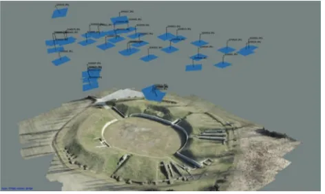
Figure 1. 3D vis Carnuntum (Austr acted fully automa
der to enhance th e interpretation g of the interact surface is esse tion represented
archaeologica ation ALS add ically short-w influencing fact c conditions) an
t independent in edge gained w M generation
2010).
evaluation ) data for aeria c reconnaissan nd on a wide ran f visibility m
us their interest (NIR) radiati gital sensors, th n be recorded w ghly 100 nm (
a characteristi g on its type, e archaeological ctral “fingerpr
hree bands of c
aging spectrosc ome the limita significantly ctures even und o systematical poses. Selected eatedly covered nd-based measu rection purpose e different data e band comb ending on the
te, spectral and stematic evalua ully covered by he success rate
sualization of the ria). The camera atically using com
et al. 2012, F
he quality of th n of the acquir ction of the emi ential. Up to
d by the ALS al interpretation ditionally provid wavelength-infr
tors (e.g. flight nd has to be cali interpretation o will help to dev
based on FW
of airbor al archaeology nce and the in ange of paramet marks. Aerial
t on the interac ion with veg hese visible and within up to th (Verhoeven 20 tic signature o environmental l structure un rint” can only
conventional im
copy devices, t ations of conv enhance the der less favourab
lly evaluates d sample-regio d by AIS sensor urements using es. The combin a focuses on th binations for
mission param d geometrical re ation concentra y geophysical e of AIS with a
e Roman civil amp positions and 3D mputer vision alg
Fig. 1).
he DTMs and to ed data, an in-tted laser beam now only the point cloud is n. Aside from des radiometric rared), which t altitude, laser ibrated in order f the data. This velop advanced WF-information
rne imaging : Conventional nterpretation of ters involved in archaeologists ction of visible etation. Using d the NIR bands hree bands with 008). However, over the entire conditions and nderneath. This y be crudely maging (Figure
there is a high ventional aerial detection of ble conditions.
AIS data for ns within case rs together with a spectrometer ned, GIS-based e evaluation of archaeological meters (sensor esolution). Data tes on selected prospection in an independent
phitheatre of D geometry is gorithms (Doneus
o International Archives of the Photogrammetry, Remote Sensing and Spatial Information Sciences, Volume XXXIX-B5, 2012
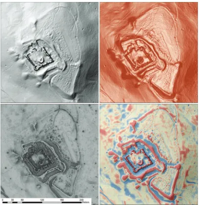
Figure 2. Visu
Figure 3.
ualisation of a filte of hillshade a
Investigating th
ered DTM of a M and slope; lower l
he spectral profile
Medieval ruined c left: positive and
e of cropmarks du
astle in the case-s negative openne
ue to stressed (blu Carnuntum.
study area St. An ss; lower right: lo
ue) and unstressed
nna. Upper left: hi ocal relief model
d (green) vegetati
illshade; upper ri and hillshade.
ion in the case-stu
ght: combination
udy area of n
3.2 Efficient
Geophysical powerful, non detailed mapp shallow subsu Neubauer, 200 ArchPro obje invasive prosp survey, resistiv
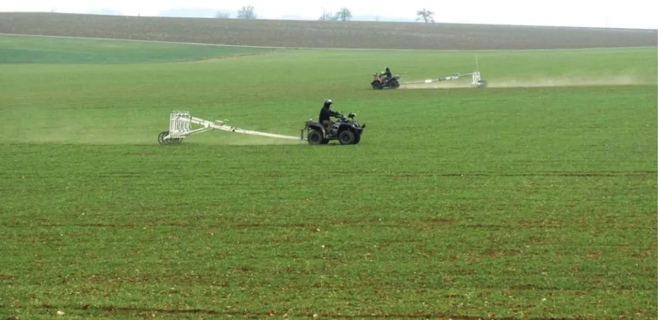
3.2.1 Motor to enable larg increase in m important is prospection ar 2009). The co sample densiti today possibl instruments an by motorized navigation so devices for technological For large-scale sensitive, mul (Pico Envirote carts, which (ATV) or Qua data logging arrangements with 25 cm cr to more than a magnetometer (Fig. 4). In cas
Figure 4. Moto solutions permit
t geophysical a
archaeological n-destructive ping of archae urface (Linford 01b; Scollar et ective to devel pection the mos vity mapping an
rized multisens ge-scale near su
measurement ssues regardi re speed, sensiti overage of cons ies at constant le by high inh nd by dramatica d multichannel olutions. The archaeological and methodolo e prospection f ltisensory Caes ec) are mount
are towed by ad bikes. The A
unit and adva with up to 10 ross-line spacin a dozen CS sens r arrays for effi se of GPR surv
orized multichann t the high-resoluti
rchaeological p
prospection o methods for eological struct d, 2006; Gaffne t al., 1990). In lop efficient t st promising m nd ground pene
sory measureme urface geophys efficiency is ng profession ivity and spatia siderably larger expenditure of herent sample ally increased s l sensor syste use of moto l prospection
gical challenge fluxgate gradiom
sium (CS) ma ed on purpose y motorized A ATVs carry th anced navigati Foerster fluxg ng on the trailer
sors will permit icient large-sca eys newly deve
nel Fluxgate grad ion magnetic arch
prospection
offers efficient the discovery tures hidden in ey and Gater, 2 n respect to the
techniques for methods are mag etrating radar (G
ent devices: In sical prospectio
needed. The nal archaeolo al resolution (Be areas and incr time in the fiel rates of the survey speed of ems and adva orized measure implicates se s.
meter (FG) and agnetometer sy e-built non-mag All Terrain Veh e power supply on systems. S gate probes mo rs, as well as a t the setup of se ale magnetic su eloped multi-ch
diometer systems haeological prosp
t and gnetic GPR).
order on an most ogical ecker, reased ld are used ffered anced ement everal
d very ystems gnetic hicles y, the Sensor ounted access everal urveys hannel
anten
s based on 10-cha pection of over 15
nna arrays (M iderably increa tly improved s lting in imag lution and struc
2 Automated
graphic data co orized multicha f paramount im ging, analysis a
ly accurate re gation are ident GPR prospectio tion. A promisi matic positioni tic total-station kebusch, 2005). navigation and ems resulting in
ity.
ographic factor ection. The lo nna tilt (Goodm aken into accou ect data project estrial laser-scan
micro-topograp ient integratio physical data pr micro-topograp will permit ication of impr iderably increa
annel digitizers, R 5 hectares per day
MIRA – MAL ased spatial co ample spacing ges of the su ctural clarity (Tr
d positioning, orrections: Exac annel sensor arr mportance for and interpretatio al-time positio tical in case of b on, permitting t ing approach ca ing technology ns with centime
. They are cruc d permit highly n considerably i
rs seriously aff ocal topograph man at al. 2006) nt during data p ion and imagin nning (TLS and hy in very high on of local to rocessing and v hy in combina for the develo oved data corre sed data and im
Realtime Kinema y and system.
LÅ Geoscience overage with of up to 4 × ubsurface of rinks et al., 201
, survey na ct real time pos rays with centim
data quality a on. The require oning systems both motorized the developmen an be realized y based on GP etre accuracy (G
cial for exact d ly efficient mo increasing effic
ffect data quali hy and corres ), in-line as cro processing in o ng. Ground and d ALS) permit
h resolution, al opography mo visualization. T ation with geop opment, imple ection algorithm mage quality.
atic GPS receiver
e AB) permit simultaneously 8 cm (Fig. 5), unprecedented 10) .
avigation and sitioning of the metre accuracy and subsequent ements for fast, and advanced d magnetometer nt of a common using real-time S systems and Gaffney, 2008; data positioning otorized survey ciency and data
ity during data sponding GPR ss-line, have to order to achieve airborne based the mapping of llowing for the odels into the The mapping of physical survey mentation and ms, resulting in
rs and navigation t
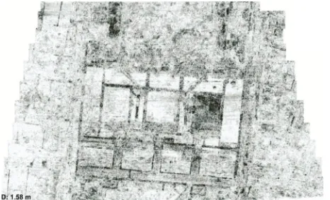
Figure 5. The GPR depth-sl
system in
3.2.3 Data geophysical d the combinati survey data de interpolation improved data archaeological data processin disturbing noi towing vehicle motorized pro which compl amplitude off different syste year, and chan A further imp the optimizat routines throug of novel data p will be the ge quality, that m interest, presen style.
3.3 Integrati spatiotempor
The LBI Arch datasets of arc data manag interpretation. including tem developed. Th acquired and p interpretative readable and r
16-channel MAL ice from approxim n the easternmost
processing a ata: The new m ion of the mi emand appropr and the imp a correction alg l geophysical p ng algorithms f
ise in the data es and multich ospection surve licates the pro fsets caused b em orientations nging weather a portant objectiv tion of the d gh implementa processing and eneration of dat most realistically
nted in a graph
ive archaeolo ral analysis
hPro research p chaeological la gement and
Therefore, no mporal relatio he main challe processed comp
archaeologica ready to use for
LÅ Imaging Rada mately 1.58 m de t room of the Foru
and visualizat motorized multi
icro-topography riate algorithms plementation a gorithms. Addi prospection su for the removal and unwanted hannel arrays. D eys lacks regu oblem of dat by measuremen
s, on different and ground cond ve of the LBI A data processing ation of improve imaging algori ta images of hi y show the sub ically suitable a
ogical data i
programme pro andscapes. Thes
an integrat ovel concepts o ons and attrib enge is the tra plex physical p al information
other archaeolo
ar Array permits epth for the first ti
um building in th
ion of large-i-sensor device y with geophy s for optimized and applicatio itionally, large-urveys require
l and suppressi d side effects o Data acquired d ular sample spa a merging du nts conducted
days, times o ditions. ArchPro is ther g and visualiz ed, and develop thms. The key t ghest resolution surface structur and easy percei
interpretation
oduces new com se demand ade ted archaeolo of dynamic an butes have to ansformation o prospection data
that is accu ogists.
the efficient surv time resolved the he Roman town o
-scale es and ysical d data during acing, ue to
with of the
refore zation pment target n and res of ivable
and
mplex equate ogical nalysis o be of the
a into curate,
The individual pillars f Carnuntum, Au
main platform be a GIS-b nded by app alization and sp rpretation, data ntenance.
Case Studies
hin the researc e been selected scapes for dis hods and techn uding remote lity and dyna rpretation. The
-study areas an he integrated pro
bringing togeth ds of high-putational scien e an active rese dards and contr rnational arch pective, the kno scientific result ine application ch will be of fu the investigati tage. The aim o
apply cutting-e oaches to illum
hectares per day s (visible as rows ustria (courtesy of
for integrated based archaeol
ropriate, easy patial analysis a archiving, da
ch programme, in order to pro tinct case stud niques mention
sensing, geop amic GIS-base proposed pres d present the la ospection appro
4. OUTL
her national and -tech archaeo nce, the LBI A arch and develo ributing at the haeological sc owledge, hard- s produced by n of novel me undamental ben
ion and protec of the LBI Arc dge technology minate archaeol
in unprecedented s of black dots) of f MALÅ Geoscie
d archaeologica logical inform y-to-use tools
for integrated data retrieval a
, various geog ovide different dies. Here, all ned above will physical prospe ed integrated sentation will f atest developme oach.
LOOK
d international ological pros ArchPro and it
opment unit, es highest levels cience. In t
and software to the LBI ArchP ethodologies a nefit to archaeo ction of endan chPro initiative y and integrated logical heritage
d resolution: this f the hypocaust ence AB).
al interpretation mation system, for dynamic archaeological and long term
graphical areas archaeological l non-invasive, be combined, ection, Virtual archaeological focus on these ents and results
experts in the spection and ts partners will stablishing new to the field of the long-term ools, as well as Pro will permit and techniques ological science ngered cultural e is to develop d interpretation e by visualising n International Archives of the Photogrammetry, Remote Sensing and Spatial Information Sciences, Volume XXXIX-B5, 2012
unique, formerly unknown, and otherwise invisible archaeological monuments and sites, which will be of great value to scientists as well as the general public alike. Providing scientists with new technological solutions, the development of novel archaeological concepts based on empirical data collected in great quality and quantity will be possible. Expanding the international LBI ArchPro case studies into large-scale applications, the work conducted within the research consortium will provide scientific access to GIS-based virtual and scalable archaeological data - from individual postholes to entire archaeological landscapes.
5. ACKNOWLEDGEMENTS
The authors wish to express their thanks to the team of the LBI ArchPro and its partners. The Ludwig Boltzmann Institute for Archaeological Prospection and Virtual Archaeology (http://archpro.lbg.ac.at) is based on an international cooperation of the Ludwig Boltzmann Society (A), the University of Vienna (A), the Vienna University of Technology (A), the Austrian Central Institute for Meteorology and Geodynamic (A), the office of the provincial government of Lower Austria (A), Airborne Technologies (A), the Roman-Germanic Central Museum in Mainz (D), the Swedish Central National Heritage Board (S), the IBM VISTA laboratory at the University of Birmingham (GB) and the Norwegian Institute for Cultural Heritage Research (N).
6. REFERENCES
Becker H., 2009. Caesium-magnetometry for landscape archaeology. In: Campana S. and Piro S. (Eds.), Seeing the unseen – Geophysics and landscape archaeology, London 2009, 129-165.
Doneus, M., Briese, C., Studnicka, N., 2010. Analysis of Full-Waveform ALS Data by Simultaneously Acquired TLS Data: Towards an Advanced DTM Generation in Wooded Areas. In: Wagner, W., Székely, B., 100 Years ISPRS, Advancing Remote Sensing Science. ISPRS Technical Commission VII Symposium, Vienna, Austria, July 5 – 7, 2010. The International Archives of the Photogrammetry, Remote Sensing and Spatial Information Sciences, Vol. XXXVIII, Part 7B, 193-198.
Doneus, M., Briese, C. 2011. Airborne Laser Scanning in Forested Areas - Potential and Limitations of an Archaeological Prospection Technique. In: Cowley D. C. (ed.) 2011, Remote Sensing for Archaeological Heritage Management, proceedings of an EAC Symposium, Reykjavik, Iceland, 25 –27 March 2010, EAC Occasional Paper No. 5, Archaeolingua.
Doneus M., Neubauer W., Verhoeven G., Briese C. 2011. Advancing archaeological airborne remote sensing. In: Drahor, M. G., Berge M.A.: Archaeological Prospection. 9th
International Conference on Archaeological Prospection.
September 19-24, 2011 Izmir-Turkey, Archaeology and Art
Publications, Istanbul 2011, 12-15.
Gaffney C. F. and Gater J., 2003. Revealing the buried past: geophysics for archaeologists. Tempus, Stroud.
Gaffney C., 2008. Detecting trends in the prediction of the buried past: a review of geophysical techniques in archaeology. Archaeometry 50, 2008, 313-336.
Goodman D., Nishimura Y., Hongo H. and Higashi N., 2006. Correcting for Topography and the Tilt of Ground-penetrating Radar Antennae. Archaeological Prospection 13, 2006, 159-163.
Leckebusch J. 2005. Precision real-time positioning for fast geophysical prospection. Archaeological Prospection 12, 2005, 199-202.
Lehner, H., Briese, C., 2010. Radiometric calibration of Full-Waveform Airborne Laser Scanning Data based on natural surfaces. In: Wagner, W., Székely, B., 100 Years ISPRS, Advancing Remote Sensing Science. ISPRS Technical Commission VII Symposium, Vienna, Austria, July 5 - 7, 2010. The International Archives of the Photogrammetry, Remote Sensing and Spatial Information Sciences, Vol. XXXVIII, Part 7B, 360-365.
Linford N., 2006. The application of geophysical methods to archaeological prospection. Reports on progress in Physics 69, 2006, 2205-57.
Neubauer W., 2001b. Images of the Invisible - Prospection methods for the documentation of threatened archaeological sites. Naturwissenschaften 88, 2001, 13-24.
Pfeifer N. and Briese C., 2007. Geometrical Aspects of Airborne and Terrestrial Laser Scanning. Keynote Lecture:
ISPRS Workshop Laser Scanning 2007, Espoo, Finland. In:
"IAPRS", XXXVI Part 3 / W52 (2007).
Scollar I., Tabbagh A., Hesse A. and Herzog I., 1990.
Archaeological Prospecting and Remote Sensing. CUP,
Cambridge.
Trinks I., Johansson B., Gustafsson J., Emilsson J., Friborg J., Gustafsson C., Nissen J. and Hinterleitner A., 2010. Efficient, larger-scale archaeological prospection using a true three-dimensional ground penetrating radar array system. Archaeological Prospection 17(3), 175-186.
Verhoeven G., 2008. Imaging the Invisible - Using modified Digital Cameras for Straightforward and Low-Cost Archaeological Near-InfraRed Photography. Journal of Archaeological Science 35, 2008, 3087-3100.