THE ENIGMATIC BENGKULU EARTHQUAKE OF 2007 1)
M. T. Z e n 2), Fiza Wira 3), and Andriansyah 4)
Abstract
The objective of this paper is to discuss some aspects of the Bengkulu 2007 earthquake which needs to be clarified or explained. A big earthquake of magnitude 8.4 hit Bengkulu on September 12, 2007 at 18;10 (West Indonesian Time). Another big one (an aftershock of the first big one?) hit Bengkulu again at 06;49 the following day, September 13, 2007.Notwithanding the sizes of these two earthquakes the distribution of the damaged areas took a very peculiar form. It is as follows:
1. The destruction inflicted by the two big shocks was practically confined to a very narrow zone or strip along the coast line.
Among the slightly damaged buildings or houses there were spots of completely destroyed buildings or houses (completely flattened to the ground).These on the other hand were relatively new buildings/houses.
2. The destruction were due to improper engineering design and construction (too heavy roofing), or poor workmanship and the use of very poor building materials.
3. Compared to the June 1914 earthquake of which destruction reached the very end of the Malayan Peninsula, Singapore, Bangka and Belitung, the damages inflicted by the 2007 Bengkulu earthquake were relatively speaking very light. How do we explain this?
Next to paying attention to the source zone areas of earthquakes, the Indonesian Gvt. and the society at large should also pay more attention to the local subsurface structures, the preparedness of the people, increasing the quality of the engineering design & construction, improving workmanship in building dwelling houses, and strengthening or retrofitting any dwelling houses in earthquake prone areas. This should be part of the national mitigation program. Ultimately the application of the building codes should be more emphasized next to engineering-housing inspection. Last but not least, the role of Research,
Could the Bengkulu 2000 earthquake, the Aceh 2004 earthquake, the Nias 2005 earthquake, the 2007 West Sumatra earthquake, and the Bengkulu 2007 earthquakes be a precursor to a much bigger one in the South, in the area between South Lampung-Sunda Strait-Southern part of West Java? Could one ignore the aftershocks of those earthquake? In that case the earthquake of September 13 2007, which had a magnitude of 8.4, must be considered to be very odd ( Is it an aftershock of the 12 September 07 earthquake, or is it a new shock/main shock of a new series of earthquakes which will lead to a new big one. The authors suggest that the earthquakes along the West coast of Sumatra be used as a test area for the EEPAS Earthquake Forecasting concept. An accurate recording, study, analysis of the numerous aftershocks along the west coast of Sumatra has to be done.
1) International Conference on Earthquake Engineering, April 14-15, 2008, Jakarta 2) Emeritus Professor in Geophysical Engineering Dpt. of ITB and Technical Advisor to
Introduction
The objectives of this paper is three fold, these are: (1) to discuss the unique position of the Mentawai Fault Zone with respect to the occurrence of large earthquakes in 1833, the earthquake in the year 2000, and the large earthquake in 2007; (2) to describe and to explain the pattern of the destructed dwelling houses and buildings along a very narrow zone along the coast of Bengkulu Province starting from Bengkulu city itself until Lubuk Pinang in the north and until the coastline of Painan in West Sumatra Province which lies adjacent to Bengkulu Province; (3) to describe the pattern of the destructions to the dwelling houses and buildings in the devastated areas.
On September 12-13 2007 two big shocks rocked Bengkulu. The first shock came on September 12, 2007 at 16:20:46, this shock had a magnitude of 8.4. Another shock with a magnitude of 7.9 hit Bengkulu again on September 13 at 06:48. The positions of the two shocks are depicted at Fig 1.
Fig. 1. The Geographic Position of the two earthquake shocks which hit Bengkulu on September 12-13, 2007
The areas affected by the 2007 earthquakes
coastal zone the town of Lais was very heavily destructed. Second came Mukomuko and Lubuk Pinang (Fig. 2).
The official statement of the Provincial Government of Bengkulu mentioned that 27.882 buildings and dwelling houses were destroyed; 26 people died and hundreds were
1. Whenever there was a dwelling house which was completely damaged or completely flattened to the ground, they were surrounded by a complex of buildings or houses
4. More often than not the destruction was due to poor masonry and poor quality of the building materials being used.
5. Bigger buildings/houses which were cracks, the cracks were usually at the joints, where two walls meet a pillar at the corners.
6. Many buildings which were cracked were already cracked at the same place during the 2000 earthquake; the cracks were plastered or closed by boat chalking material (dempul), and painted.
7. Most of the buildings and dwelling houses which were destroyed were small to very small houses.
Seismic History of offshore Bengkulu-West Sumatra.
Fig. 2. The inflicted area by The Bengkulu September 12-13, 2007 earthquake (the blue colored line)
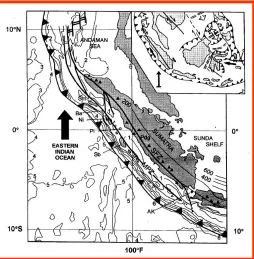
Seismotectonics of the Sumatra Sliver Plate.
Fig 3. A schematic seismotectonic map of Sumatra depicting the Sumatra Fault Zone, the Mentawai Fault Zone, and the Sumatra Subduction.
The Mentawai Fault zone is a back thrust fault with a very low dipping angle. The earthquakes in the year 2000 and in 2007 were all related to the Mentawai fault zone and probably also the great earthquake in 1833. A big rupture occurred in 1833. During the earthquakes of 2007 the ruptures were relatively small. The area between the Sumatra Fault Zone and the subduction zone is called the Sumatra Sliver Plate (Moore et al., 1980) moved northwestwardly and create the opening of the Sunda Strait (Huchon and Le Pichon, 1984). Recent geodynamic studies in this area resulted in the opinion that the extension in the Sunda strait was related in time with the opening of the Andaman Sea (Lassal et al, 1989). However, the 460 km of the total displacement in the Andaman sea could not entirely be accounted by the displacement along the Sumatra Fault Zone which is estimated to about 180 km (Page et al, 1979) at the north end of Sumatra island and even less than 70 km by the extensional motion in the Sunda strait. The 40/mm year opening rate at the Andaman Sea is not compatible with the previous tectonic study in the southern part of the SFZ which gave only a strike slip velocity of 6 mm /year. This value is in accord with Lassal et al, 1989. (see Fig. 4).
200 200 200
2000
BIG EARTHQUAKES IN SUMATRA 1897 - 2007
Fig.4. A seismotectonic sketch map showing the segments of the Sumatra Fault Zone and the Mentawai Fault Zone
Local Soil Condition and Engineering Constructions
Until so far the society at large paid more attention to the seismic source zone problems, but much less attention to the local soil conditions and engineering construction & design, the craftsmanship in building the dwelling houses. We assume that with the elapse of time and development processes the latter problems should come much more into the fore. Engineering works should be more scrutinized. As an example this paper will only mention the Yogya earthquake in 2006 which was relatively small (M=6.2 on the Richter scale). Nevertheless it caused very heavy damages due to two factors. One is the very soft soil condition (unconsolidated sediments and loose volcanic products) and the very poor constructions of buildings or dwelling houses.
The same situation is also valid for Jakarta. This city is built on very soft water rich unconsolidated quaternary sediments. Numerous high rise buildings are found in Jakarta, and more will be built. The northern part of Jakarta is found very vulnerable (See Fig. 6a and 6b). The R&D Department of Maipark discovered recently two rather big earthquakes occurring in historical time; one in 1757 and another one in 1863 along the North coast of Jakarta. The one in 1757 produced a tsunami with a maximum run off of ± 3 meters. Besides, very recently (in 2007) the Jakarta earthquake or the Indramayu earthquake was quite deep, and rather small. Still it cracked some buildings in Jakarta, and some damage to quite a number of houses in Sukabumi, a city in the south coast of West Java, and in Indramayu, a city along the north coast of West Java, close to Cirebon (Waspada, Maipark Newsletter, October issue, 2007). It means that Jakarta is not completely free from earthquakes. The first author of this paper mentioned on October 30, 2007 that if an earthquake of magnitude ≥8 to the Richter scale hits a city like Jakarta the economic loss might run between 4-6% of Indonesia’s GDP (2007). In money terms that means US$18-22 bill. Not to mentiom the disruption of the economic process in the broad sense. One of the participants commented that the figure mentioned was very much on the conservative side.
Fig 6a. The intensities (MMI scale) of simulated Jakarta 1757 earthquake which had a magnitude of 7.5 on the Richter Scale.
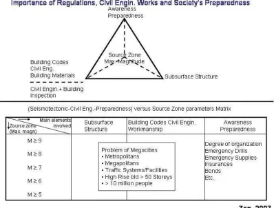
Experiences from Bengkulu also confirmed that faulty engineering constructions and poor craftsmanship contributed very much to the completely destroyed new buildings in Bengkulu, in Lais, and in Lubukpinang (Maipark’s Waspada, October 2007 issue). The relationship between source zones, local soil conditions, and the engineering construction is schematically depicted in Fig. 7
Fig. 7. Source zone problems are important, but the local subsurface structures, the preparedness of the people, the civil engineering works, and the craftsmanship in building the houses including using good
quality building materials are of great importance in the mitigation program.
Discussion on Some Unanswered Questions
After so many things have been said, still many more things remain still unanswered. There are at least 3 things which have to be explained.
1. The Bengkulu September 12-13, 2007 earthquakes were big earthquakes. How can we explain that relatively speaking the damaged area were only confined to a very narrow strip of an area along the coastal zone of Bengkulu-West Sumatra Province. 2. Compared to the June, 1914 earthquake discussed by Newcomb and McCann (1987)
Fig 8. Some historical earthquake affecting the West coast of Sumatra mentioned by Newcomb and McCann (1987).The earthquake of June 1914 affected a very large area. It reached the southern end of the
Malayan Peninsula, Singapore, the whole southern part of Sumatra including the islands of Bangka and Belitung. The September 2007 shocks were very big shocks (M=8.4 and M=7.9). Logically these two
shocks must have a wider area of destruction. In fact it did not.
3. Along the road between Bengkulu City and Mukomuko practically no significant horizontal displacements were observed except for on the steel-concrete bridge over the Lais River. The observed offset were between 15-20 cm long.
5. Can we consider the Bengkulu 2004 earthquake as the first precursor leading to the Aceh 2004 (M=9.2) earthquake, then to the Nias 2005 earthquake, the West Sumatra 2007 earthquake leading to the Bengkulu 2007 earthquake. Where does one go from there? Most probably to the areas of south Lampung and the southern part of West Java (see fig. 8).
It is generally assumed that earthquake occurred randomly (Poisson Model). The authors did not agree with this assumption. Earthquakes do not occur randomly (most, if not all, natural phenomena which seem to occur randomly, are not random at all if one scrutinize it through fractal mechanics (Mandelbrot, 1977) or by means of complexity (Peitgen et al, 1992) and Non Linear Dynamics (Dubois, 1995).
The EEPAS forecasting model makes the simplifying assumption that every earthquake is a precursor to future earthquakes. Sommerville et al (2007) mentioned specifically: “This is not demonstrably true, and to the extent that it is not true, the forecast model is subject to error”. This is an important and honest statement. We must give credit to Sommervile et al (2007) and give some time to them to perfect the EEPAS Approach. Science, especially earth sciences like geodynamics and seismology need time to grow. We need time to observe, analyze, and build a theory. As Tennyson said: “Science moves, but slowly, creeping from point to point” Building Science is like building a pyramid, laying stone by stone by thousands, maybe hundreds of thousands of laborers. This in particular must be understood by the Indonesian Society at large. Those stones making the foundation of the Pyramid are the data collected and classified by scientists working tirelessly without a clear sight at the end of the tunnel except for a strong believe and conviction that there is a kind of regularity in nature. It reveals itself only to those who are able to pose very intelligent questions, qed!
Conclusions and Recommendations
1. The September 2007 Bengkulu earthquakes were large. Nonetheless they inflicted very minor damages which were confined to a very narrow strip along the coastal zone of Bengkulu.
2. Most of the heavily or completely destroyed houses or buildings were relatively new. Besides, most were due to a faulty engineering design, and by the use of low quality building materials.
3. Except for a very small horizontal offset on the bridge over the Lais River in Lais, very little horizontal displacements were observed.
4. It is long overdue that regular engineering and building inspections are being practiced with penalties to those who do not comply with the regulations.
5. Specifically for the earthquake Engineering discipline it is indeed important not to pay attention to the earthquake source zones only, but to also scrutinize the subsurface structures of areas where rapid development are taking place in commensurate with the application of building codes and by using a-seismic construction design accompanied by retrofitting of houses in earthquake prone areas. 6. It is worthwhile for Indonesian seismologists and earthquake engineers to scrutinize
7. Research, Development and Innovation must become an integral part of the National Disaster Management Program in the form of a board of experienced scientists who can provide suggestions and recommendations concerning what researches to be undertaken, and to provide recommendations for long term policy formulations. 8. It is no longer advisable for the Gvt to be the sole responsible entitiy which should
bear the financial burden of rehabilitation and reconstruction phase after any disaster. Part of the risk could and should be transferred to the private sector in the form of a Public-Private-Partnership principle. In other words the insurance industry must be involved.
9. Indonesia must start to change from the traditional post disaster rescue operation into a culture of mitigation and prevention. Basically this is a cultural change using the mitigation of disasters as a vehicle in the process of empowering the people.
References
1. Asian Disaster Reduction Center. Concept of Total Disaster Risk Management. 2005. 2. Diament, M., Deplus, C., Harjono, H., Larue, M., Lassal, O., Dubois, J., Renard, V.
Extension in the Sunda Strait (Indonesia): A Review of the Krakatau Programme. Oceanologia Acta, special volume 10, p31-42, 1990.
3. Dubois. J., La Dynamique Non Linéaire. Massom. Paris, 1995.
4. Huchon, P., and Le Puchon, X., Sunda Strait and Central Sumatra Fault. Geology, Vol. 12, pp. 668-672, 1984.
5. Lassal, O., Huchon, P., Harjono, H., Extension crustale dans le Detroit de la Sonde (Indonesia). Donnee de la seismic reflection (Campagne Krakatoa). C. R. Acad. Se. Paris, vol. 309, pp. 205-212.
6. Mandelbrot, B., The Fractal Geometry of Nature. W.H. Freeman and Company, New York, 1983.
7. Moore, G. F., Curray, J. R., Moore, D. G., Karig, D. E., Variations in geologic structure along the Sunda Fore-arc, North-eastern Indian Ocean. Jr Hayes, D. E. ed. The Tectonic and Geologic Evolution of South East Asian Seas and Islands. Am. Geoph. Union Monograph Memoir 23, pp. 145-160, 1980.
8. Newcomb, R. R., McCann, W. R., Seismic History and Seismotectonic of the Sunda Arc. Journ. of Geophys. Res., vol 92, pp. 421-439, 1987.
9. Page, B.G.N., Benett, J. D., Cameron, N. R., Bride, D. Mc. C., Jeffreys D.H., Keats, W., Thaib.j., A review of the main structural and magmatic features of Northern Sumatra. Geol. Soc. of London Journ., VB6, pp. 569-579, 1979.
10.Peitgen, H., O., H. Jurgens, D. Saupe, Chaos and Fractals (New Frontier of Science), Springer Verlag, New York, 1992.
11.Rhoades, D. A. and F.F. Evison, The EEPAS forecasting model and the probability of moderate to large earthquakes in central Japan. Tectonophysics 417, 119-130, 2007. 12.Silver, Eli A., Geodynamic Processes in Foreacrs. Proceedings of the Intern. Seminar
on Geodynamic Processes in Conjunction with the 16th Annual Convention of the Ind. Geophysicists (HAGI), Bandung, October, 1991.
14.Zen Jr, M. T., Deformation de L’Avant-Arc en Reponse A Une Subduction A Convergence Oblique Example De Sumatra. These pour obtenir Le Doctorat de Geophysique Interne, Université de Paris VII, Paris, 1993.
15.Zen, M. T., Krakatau and the Tectonic Importance of Strait Sunda., Bull. Jur. Geologi. V12, 1983.
16.Zen, M. T., Report on the Bengkulu Earthquakes of September 12-13, 2007. Unpublished Report. Maipark, 2007.