AN INTERCOMPARISON OF PASSIVE TERRESTRIAL REMOTE SENSING
TECHNOLOGIES TO DERIVE LAI AND CANOPY COVER METRICS
W. L. Woodgate
Dept. of Infrastructure Engineering, The University of Melbourne, Australia – w.woodgate@pgrad.unimelb.edu.au
Technical Commission VIII, WG 7 (Forestry)
KEY WORDS: LIDAR, Forestry, Sustainable, Multisensor, Scale, Terrestrial
ABSTRACT:
Forest indicators such as Leaf Area Index (LAI) and vegetation cover type are recognised as Essential Climate Variables (ECVs) which support the ‘…research, modelling, analysis, and capacity-building activities…’ requirements of the United Nations Framework Convention on Climate Change. This research compares the use of passive terrestrial remote sensing technologies for LAI and canopy cover metrics. The passive sensors used are the LAI-2200 and Digital Hemispherical Photography (DHP). The research was conducted at a Victorian reference site containing tree species with predominantly erectophile leaf angle distributions, which are significantly under-represented in the literature. The reference site contributes to a network of sites representative of Victorian land systems and is considered to be in good condition. Preliminary results indicate a low correlation (R2=0.46) between the LAI-2200 and DHP. Further comparisons to be conducted include adding a passive CI-110 plant canopy analyser and an active Terrestrial Laser Scanner. The future objective is to scale the in situ data to aerial and satellite remotely sensed datasets. The aerial remotely sensed data include LiDAR flown by a Riegl LMS Q560, and high resolution multispectral and hyperspectral imagery flown by the ASIA Eagle and Hawk system. The in situ data can be utilised for both calibration and validation of the coincident aerial imagery and LiDAR. Finally, the derived datasets are intended for use to validate the global MODIS LAI product.
1. INTRODUCTION
Sustainable forest management is fundamental to the preservation of biodiversity and mitigation of climate change (Garnaut, 2008; Lanly, 1995). Delineating criteria and indicators that provide valuable information on forests are important to assist sustainable forest management (Raison et al., 1998). Leaf Area Index (LAI) has been recognised as a key forest indicator and is one of the Essential Climate Variables which support the ‘…research, modelling, analysis, and capacity-building activities…’ requirements of the United Nations Framework Convention on Climate Change (UNFCCC) (GCOS, 2010). Another key forest indicator is canopy cover which is a primary requirement for the definition of forest as recognised by the United Nations Food and Agricultural Organisation (FAO) (FAO, 2010).
LAI is a quantitative measure of the amount of leaf tissue in the canopy per unit of ground area (GTOS, 2009). It is broadly defined as ‘leaf area per unit area of land’ (Watson, 1947). LAI is a non-dimensional measurement, but is usually quantified as m2 of leaf area per m2 of ground area. (Running et al., 1986) identified LAI as ‘the single variable both amenable to measurement by satellite and of greatest importance for quantifying energy and mass exchange by plant canopies over landscapes’.
‘Canopy cover refers to the proportion of the forest floor covered by the vertical projection of the tree crowns’ (Jennings
et al., 1999). Canopy cover and variations of cover such as Foliage Projective Cover (FPC) provide a useful measure of the
amount and distribution of foliage and allow for analysis at a number of spatial scales (White et al., 2000).
Remote sensing technologies can be utilised to indirectly derive both LAI and canopy cover metrics. Remote sensing technologies enable the landscape to be analysed at multiple scales from ground, airborne and spaceborne platforms (Zheng & Moskal, 2009). The technologies can categorise their sensors as being either passive or active. Terrestrial remote sensing technologies used to derive LAI and canopy cover metrics are important for calibration and validation of datasets derived from the airborne and spaceborne platforms (Baret, 2007; Morisette, 2006).
Passive sensors, such as imagery, can only detect energy when naturally occurring energy exists (Zheng & Moskal, 2009). Whereas active sensors, such as LiDAR, emit their own energy source and record the energy returned from objects of interest (Zheng & Moskal, 2009). The advantage of an active sensor over a passive sensor is that it is independent of the naturally occurring energy in the environment. Active sensors are not limited in their time of operation by environmental conditions such as the amount of sunlight available.
(INRA, 2010). Airborne and spaceborne technologies derive LAI through transfer functions from the terrestrial data (Zheng & Moskal, 2009). However, indirectly deriving LAI and canopy cover metrics has limitations.
The formula to derive LAI and associated metrics from gap fraction assumes a random distribution and angle of foliage within a canopy. However, in the Australian context these assumptions of deriving LAI from gap fraction are not always met (Coops et al., 2004). Eucalypt species commonly found in Australia have a trait of heliotropic leaves, which breaches the assumption that the foliage orientation is random within the canopy (Caldas et al., 1997). These leaf traits make Australian forest species unique to most other species found around the world. The variety of active and passive terrestrial remote sensing technologies indirectly measuring LAI will be used to investigate the impact of leaf angle distribution.
There have been few studies conducted in natural forested environments in Australia examining LAI (Coops et al., 2004). There is a lack of research focusing on leaf clumping and leaf angle distribution of representative Australian vegetation using terrestrial remote sensing technologies. Furthermore, there has been little research undertaken in testing sampling schemes in Australian conditions. (Hill et al., 2006) stated that the global MODIS LAI product could benefit from an examination of the structural components of Eucalypt forest canopies for Australia.
The main aim of this research is to contribute to the body of knowledge for LAI and canopy cover metrics over representative Australian forests. Specifically, this research looks at the level of variability among the suite of terrestrial remote sensing instruments used to derive LAI and canopy cover metrics in different forest conditions. The comparison of active and passive ground based sensors will occur at two study sites in Victoria representative of natural land systems. One study site is representative of a dry sclerophyll forest, while the other is a dense wet forest with a colder climate. The specific passive instruments used for comparison were the DHP, LAI-2200, and CI-110. The active instrument to be utilised is the Leica Scan Station II TLS. Results reported in this study are between the DHP and LAI-2200 over a subset of the Rushworth sample area. The results indicate a poor correlation for LAI derived from the in the dry sclerophyll forest.
This research is aligned with the Cooperative Research Centre for Spatial Information’s (CRC-SI) Project 2.07 (CRC-SI, 2012). The main objective of Project 2.07 is to derive woody features and metrics at the landscape level for land managers over representative forests for broad-scale use throughout Australia.
This research has two longer term objectives not reported on in this study. Firstly, to characterise both study area’s variability of LAI and cover metrics using active and passive terrestrial sensors. Each area is to be stratified and randomly sampled at the plot scale. Determining the plot variability will be investigated through testing a variety of gridded and transect based sampling strategies in order to determine the minimum number and configuration of measurements to characterise each metric at the plot scale. A second research aim is to use the remotely sensed terrestrial data to validate and calibrate aerial
and satellite datasets for LAI and canopy cover metrics. Ultimately, a validation of the MODIS LAI product will be completed.
2. METHODS
2.1 CRC-SI Project 2.07
CRCSI Project 2.07 commenced in July 2011 and will continue to the end of 2014. The main objective of Project 2.07 is to delineate key woody features and metrics and derive them at the landscape level for land managers over representative Victorian forests. The metrics will be derived from the in situ
to site scale. This research is primarily concerned with upper canopy metrics such as LAI and canopy cover. Three study sites located in Victoria, Australia have been identified for Project 2.07. Each 5x5km site was specifically chosen to be representative of Victorian land systems. The three areas are Rushworth, Watts Creek and Zig Zag Creek. The focus of this research is on a subset of the Rushworth and Watts Creek study areas.
2.2 Study Areas
Both study areas are relatively undisturbed. It is considered by the managing agency (Department of Sustainability and Environment, Victoria) that the public lands on which the forests reside represent largely intact, natural and sustainable ecosystems.
Figure 1: Location of the CRC-SI Reference Areas
‘Box Ironbark Forests or dry/lower fertility Woodlands’ and ‘Dry Forests - Exposed and/or lower altitude’.
The topography of Rushworth is mainly low-lying undulating land with a few minor gullies. The elevation ranges from 195m to 240m above sea level. Typical of the box-ironbark forests, no streams in the area carry permanent water but rather act as drainage lines. The climate is Mediterranean with hot, drought-prone summers and cool winters.
Watts Creek: The Watts Creek Reference Area (37°41’S, 145°41’E) is located on the slopes of Mount Donna Buang. The area largely comprises a mature open forest of Mountain Ash (Eucalyptus regnans). Regrowth and older mature stands of Mountain Ash, Shining Gum (Eucalyptus nitens) and Alpine Ash (Eucalyptus delegatensis) occur at higher elevations and there is a small area of scrub. The other structural form is closed forest Myrtle Beech (Nothofagus cunninghamii) in the main stream gullies. The dominant EVCs are ‘Wet or Damp Forests – Damp’ with smaller areas of ‘Rainforests’ and ‘Riparian Forests or Woodlands’. There are very small areas where the EVC contains areas with no vegetation. Watts Creek is representative of the plateaux and slopes of the upper watershed areas south of the Great Dividing Range. It has been part of Melbourne’s water supply catchment since 1891.
The elevation ranges from 900m to 1220m above sea level. The slopes have been steeply dissected by the young degrading Watts Creek tributaries. Slopes of the order of 15° to 20° can be found. The climate of the upper Watts River watershed is cool, wet and temperate. There exists a pattern throughout the area of increasing rainfall and decreasing temperatures with elevation.
2.3 Terrestrial Remote Sensing Instruments
A variety of active and passive terrestrial remote sensing instruments are intended to be utilised in this research. It must be noted that the metric being derived is in fact Plant Area Index (PAI) instead of LAI, as the gap fraction method fails to differentiate between foliage and non-foliage elements of vegetation (Coops et al., 2004).
LAI-2200: The LAI-2200 Plant Canopy Analyser is a passive sensor used to compute LAI and a variety of other canopy structure attributes from radiation measurements. The instrument is made with a fish-eye optical sensor. The ceptometer sensor has five circular rings sampling a 148° field of view (FOV). Measurements are made both above and below the canopy in order to determine a ratio of the radiative transfer of sunlight through the canopy. It is a proven method to determine LAI and related gap fraction metrics (Chen et al., 1991).
DHP: Digital Hemispherical Photography is a passive sensing technology that provides a large FOV image at the point of capture. The DHP setup used in this research comprises a Nikon D90 Digital SLR camera with a Sigma EX 180° 4.5mm circular fisheye lens. The resolution of the camera is 12.3MP. Gap fraction is calculated through classification of the image into sky and non-sky elements (Chen et al., 1991).
CI-110: The CI-110 is passive self-levelling imaging sensor. It has a 180° FOV and a 24 sensor Photosynthetically Active Radiation (PAR) wand used to measure the amount of incident solar radiation in the visible spectrum. The imaging device is restricted to a resolution of 0.4MP, which is much lower than the Nikon D90 SLR. The gap fraction is calculated with the same method as the DHP, where the image is classified into sky and non-sky elements.
TLS: Terrestrial laser scanners produce a very dense 3D point cloud, which provides a rich representation of the forest environment from the ground up (Vosselman & Maas, 2010). The TLS to be used in this research is the Leica Scan Station II. The Scan Station II is a survey grade accuracy TLS and has a range of 300m at 90% reflectivity. It has a 360° horizontal and 270° vertical FOV. It attributes each point with a red, green, and blue (RGB) colour value. The laser is Class 3R, operating in the Green band (106-302nm). TLS has can be used to derive gap fraction from the ratio of received returns to total emitted points (Danson et al., 2007).
Modified densiometer: Traditionally, FPC is derived using a densiometer attached to the end of a pole which has been adjusted to the operator’s height. A laser rangefinder is attached to the end of the pole with the densiometer. The rangefinder records the height to the first vegetation or canopy intercept. This provides a characterisation of the bottom of the canopy. The laser rangefinder attached to the pole is the Trimble Trupulse. The height and FPC metrics will be used to validate the FCOVER metrics from the DHP and CI-110. The rangefinder measurements will be used to compare against the TLS point cloud.
2.4 Terrestrial Instrument Comparison
The first aim of this research was to conduct a comparison of active and passive terrestrial remote sensing technologies available to produce LAI and canopy cover metrics. The instruments to be used for comparison are; DHP, LAI-2200 and CI-110 for the passive sensors, and the TLS for the active sensor. However, results from only the DHP and LAI-2200 over a subset of the sampling design will be presented here.
The comparison was conducted at Rushworth to provide an indication of the degree of interoperability and transferability of technologies and methods. A gridded sampling design was developed to compare the instruments over a number of points at one sample location in Rushworth (see Figure 2).
The 40x40m grid consists of three areas of varying sample density. At the centre of the plot there is an 8x8m grid sampling at the highest density of every 1m. Surrounding the 1m grid is a 24x24m grid sampling every 2m. The 2m grid extends out to the 40x40 grid sampling at the lowest density of every 4m. There are 81 points at the 1m density, 144 points at the 2m density, and 72 points at the 4m density, totalling 297 points for the 40x40m grid.
density for the 72 outer points. The TLS is scheduled to be captured for the centre point of this grid for later comparison.
Figure 2: Gridded sampling design for the Rushworth plot.
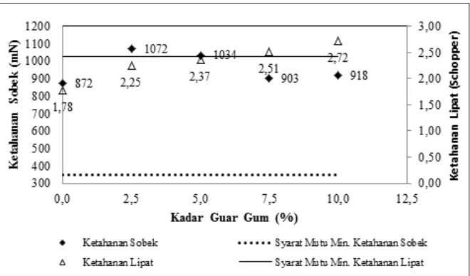
An initial comparison was conducted for LAI between the LAI-2200 and the DHP for 72 points sampled at the 4m density (Figure 2). The mean values for the LAI-2200 and the DHP are 0.95 and 0.50 respectively (Table 1).
Figure 3: LAI comparison of LAI-2200 and DHP
LAI (2200) LAI (DHP)
Mean 0.95 0.50
Standard Error 0.02 0.01
Std Deviation 0.18 0.08
Range 0.87 0.41
Minimum 0.65 0.34
Maximum 1.52 0.75
Table 1: LAI summary statistics for LAI-2200 and DHP
A large discrepancy was found between the mean LAI values. The graph in Figure 3 demonstrates the bias between the two technologies. The DHP is consistently providing an LAI value lower than the LAI-2200. However, correlating the two technologies produced an R2 of 0.46 (linear regression intercepting LAI-2200 vertical axis at 0.23) which indicates an inconsistent bias.
The results for LAI produced by the DHP and LAI-2200 are different from the comparison reported by Coops et al., (2004). Coops et al., (2004) found that the DHP and LAI-2000 produced higher R2 value of 0.65 for a linear regression with an intercept at the LAI-2000 axis at 0.72.
Further differences between the two studies may be explained by vegetation type, number of measurements, measurement aggregation, and different DHP processing software to derive LAI. The dominant tree species found in the Coops et al., (2004) were the Eucalyptus delegatensis and the Eucalyptus dalrympleana. These species are significantly taller and produce a more uniform upper canopy to the species found in Rushworth. Furthermore, the mean LAI values reported in Coops et al., (2004) are greater than the study area in Rushworth, and are indicative of the lower biomass of the tree species found in Rushworth. Coops et al., (2004) also aggregated plot measurements, whereas this study compared individual measurements over one plot. Lastly, different software packages were used to derive LAI from DHP in the two studies. Coops et al., (2004) used HemiView 2.1 software which requires the user to manually define a threshold for classifying the image into sky and non-sky elements for gap fraction analysis. Conversely, the DHP software used in this study automatically thresholds each image.
2.5 Further Analysis to be completed at Rushworth
The gridded sampling strategy provided an increased coverage area for a similar time cost by modifying the measurement spacing. The strategy will allow for a comparison of results at a variety of sampling densities and designs (Nelder, 1962). The design allows for comparison at the point level of a variety of metrics, and also enables comparisons to be undertaken at a variety of scales through aggregation of measurements.
The comparison of metrics at the individual point scale will be extended to MTA, FAPAR and FCOVER metrics for both the DHP and CI-110 data. Comparing the same metrics from different technologies is important for determining the degree of consistency within each study area. Different metrics will be correlated against each other to determine the degree of relatedness.
Another factor of significance for LAI is the ratio of woody to non-woody vegetation. The FPC transect will enable the ratio of woody to non-woody vegetation to be calculated. This ratio could be utilised when determining the link between LAI and PAI.
The aggregation of point scale measurements for comparison enables different metrics to be correlated with each other over multiple scales. Aggregation is relevant as each instrument has a varying FOV and sample radius. For example, FCOVER produced by the passive imaging devices is derived over a FOV, which allows for the FPC value to be aggregated of the same FOV for comparison. Furthermore, FCOVER can be aggregated and averaged at the plot scale and then compared to the site’s aggregated FPC value.
minimum number of measurements and their location to be determined in order to characterise the variability of each metric for the entire plot. This will provide insight as to the approximate sampling scheme required for each plot location as each site is relatively homogenous.
A further comparison will be made between the height profile from the modified FPC and the bottom of canopy returns from the TLS data. The dense TLS dataset will provide a reference dataset for the modified FPC measurements and give an indication of the robustness of the FPC sample density.
An investigation will be conducted to determine whether a more accurate extent of the individual FOV point measurement from the passive sensors can be derived from TLS. The restricted FOV from each passive instrument will be projected out from the centre of the TLS point cloud to determine a theoretical extent of the sampling radius. The restricted FOV will be 115 degrees, as the 57.5 degrees azimuth angle was found to be favourable to derive LAI (Wilson, 1963). Once the approximate sample radius is calculated, it will be utilised as a more geometrically accurate sample size at each point measurement for validation and calibration of aerial and satellite remote sensing datasets.
2.5 Future Planned Research
As Project 2.07 is still in the first year of a three year study, the majority of the research is yet to be conducted. The two study areas that are the focus of this future research are Rushworth and Watts Creek. Both areas provide for a good comparison as the vegetation species and distribution are different, as well as climatic factors. Below is an outline of a subset of future planned activates, intended research and preliminary methodology.
Airborne data collection: Aerial data consisting of ALS and imagery will be acquired at the 5x5km extent for each site. The ALS scanner to be flown is a Riegl LMS Q560. The approximate flying height is 1km and a ground sample density of 20 points/m2. The absolute horizontal and vertical accuracies expected are ±0.3m and ±0.2m respectively. The ASIA Eagle and Hawk passive scanners are to be flown to provide a seamless high spatial resolution (<1m pixel size) dataset (NERC, 2012). The sensors provide radiometric resolution from 400nm to 2500nm.
Study Area Scale Characterisation: A major aim is to collect the in situ data for scaling to aerial and satellite remotely sensed datasets. The in situ data will be utilised for both calibration and validation of the aerial imagery and LiDAR captured for Project 2.07. The site sampling scheme is pivotal to ensure the in situ data will provide a robust scaling method.
The centre 3x3km of the site is to be stratified into nine 1km grids, each with one randomly selected plot location. The sampling design for each plot will follow the SLATS Star Transect protocol (TERN, 2012). The design consists of three 100m long transects centred at the middle of the plot (Figure 4). The first transect is aligned in the North-South direction, where the next two transects are placed at 60° rotations from the centre point.
For each of the three 100m transects, an LAI value is recorded at every meter interval using the LAI-2200, totalling 300 measurements. The DHP and CI-110 capture one image at the centre of the plot, one image at each point 25m away from the centre, and one image at the end of each arm, totalling 13 images from each instrument. The TLS is to complete one scan at the centre point. However, due to logistical constraints the TLS will be utilised at only a subset of the nine plots for each site.
Figure 4: SLATS Star Transect Sample Design.
The in situ measurements will be related to the passive aerial datasets though transfer functions (Zheng & Moskal, 2009). Transfer functions enable the metric to be derived at the scale of the data captured by remote sensing instrument. ALS can derive gap fraction through ratios of below canopy returns to total returns (Morsdorf et al., 2006). A future aim is to compare the LAI derived dataset at the site scale against the MODIS LAI product. Furthermore, the MODIS product could be validated from the in situ measurements collected from this research.
3. CONCLUSION
LAI and canopy cover are important for forest managers and decision making. This paper outlined a comparison between two passive terrestrial remote sensing technologies used to derive LAI metrics. The area investigated contained dry sclerophyll forest is representative of vegetation found in Victorian land systems. Preliminary results indicated a poor correlation between two passive instruments for deriving LAI. Future research will be conducted to examine the differences in instruments and methods, and include other active and passive terrestrial sensors for comparison. The in situ data can be utilised for both calibration and validation of the coincident aerial imagery and LiDAR.
4. REFERENCES
Baret, F., Hagolle, O., Geiger, B., Bicheron, P., Miras, B., Huc, M., et al. (2007). LAI, fAPAR and fCover CYCLOPES global products derived from VEGETATION. Part 1: Principles of the algorithm.
Remote Sensing of Environment, 110(3), 275-286.
woody legume from the Brazilian Cerrado. Revista Brasileira de Fisiologia Vegetal, 9(1), 1-7.
Chen, J. M., Black, T. A., & Adams, R. S. (1991). Evaluation of hemispherical photography for determining plant area index and geometry of a forest stand.
Agricultural and Forest Meteorology, 56(1-2), 129-143.
Coops, N. C., Smith, M. L., Jacobsen, K. L., Martin, M., & Ollinger, S. (2004). Estimation of plant and leaf area index using three techniques in a mature native eucalypt canopy. Austral Ecology, 29(3), 332-341. CRC-SI. (2012). Woody vegetation (2.07). Retrieved 11/04/
2012, from http://www.crcsi.com.au/Research/2-Feature-Extraction/2-07-Woody-Vegetation, accessed 12 April 2012.
Danson, F. M., Hetherington, D., Morsdorf, F., Koetz, B., & Allgower, B. (2007). Forest canopy gap fraction from terrestrial laser scanning. Geoscience and Remote Sensing Letters, IEEE, 4(1), 157-160.
FAO. (2010). Forest and climate change working paper 4. Rome: FAO.
Fu, Z., Wang, J., Song, J., Zhou, H., Pang, Y., Cai, W., et al. (2009). Forest canopy structural parameters and leaf area index retrieval using multi-sensors synergy observations.
Garnaut, R. (2008). The Garnaut climate change review: Final report. Port Melbourne, Vic.: Cambridge University Press.
Garrigues, S., Shabanov, N. V., Swanson, K., Morisette, J. T., Baret, F., & Myneni, R. B. (2008). Intercomparison and sensitivity analysis of leaf area index retrievals from lai-2000, accupar, and digital hemispherical photography over croplands. Agricultural and Forest Meteorology, 148(8-9), 1193-1209.
GCOS. (2010). Implementation plan for the global observing system for climate in support of the UNFCCC.
http://www.wmo.int/pages/prog/gcos/documents/GC OSIP-10_DRAFTv1.0_131109.pdf. accessed 12 April, 2012.
GTOS. (2009). Assessment of the status of the development of the standards for the terrestrial essential climate variables: LAI, GTOS 66
Hill, M. J., Senarath, U., Lee, A., Zeppel, M., Nightingale, J. M., Williams, R. J., et al. (2006). Assessment of the modis lai product for australian ecosystems. Remote Sensing of Environment, 101(4), 495-518.
INRA. (2010). Can-eye v6.1 user manual: INRA.
Jennings, S. B., Brown, N. D., & Sheil, D. (1999). Assessing forest canopies and understorey illumination: Canopy closure, canopy cover and other measures. Forestry, 72(1), 59-73.
Lanly, J.-P. (1995). Sustainable forest management: Lessons of history and recent developments. Unasylva, 46(182), 38-45.
Morisette, J. T., Baret, F., Privette, J. L., Myneni, R. B., Nickeson, J. E., Garrigues, et al. (2006). Validation of global moderate-resolution LAI products: A framework proposed within the CEOS land product validation subgroup. IEEE Transactions on Geoscience and Remote Sensing, 44(7)
Morsdorf, F., Kötz, B., Meier, E., Itten, K. I., & Allgöwer, B. (2006). Estimation of lai and fractional cover from
small footprint airborne laser scanning data based on gap fraction. Remote Sensing of Environment, 104(1), 50-61.
Nelder, J. A., (1962). New kinds of systematic designs for spacing experiments. Biometrics, 18(3), 283-307.
NERC. (2012, 22/10/2010). The specim asia eagle and hawk. from http://arsf.nerc.ac.uk/instruments/specim.asp, accessed 12 April 2012.
Raison, R. J., Brown, A. G., & Flinn, D. W. (1998). Criteria and indicators for sustainable forest management. In IUFRO/CIFOR/FAO (Ed.), Sustainable forest management: fostering stakeholder input to advance development of scientifically based indicators. Melbourne, Australia: IUFRO/CIFOR/FAO.
Running, S. W., Peterson, D. L., Spanner, M. A., & Teuber, K. B. (1986). Remote sensing of coniferous forest leaf area. Ecology, 67(1), 273-276.
TERN. (2012, 06/12/11). SLATS star transect protocol.
Retrieved 12/04/12, from
http://data.auscover.org.au/xwiki/bin/view/Field+Site s/Star+Transect+Protocol+Web+Page, accessed 12 April 2012.
Vosselman, G., & Maas, H. G. (2010). Airborne and terrestrial laser scanning. Whittles Publishing, UK, pp. 1-336 Watson, D. J. (1947). Comparative physiological studies on the
growth of field crops: I. Variation in net assimilation rate and leaf area between species and varieties, and within and between years. Annals of Botany, 11(1), 41-76.
White, M. A., Asner, G. P., Nemani, R. R., Privette, J. L., & Running, S. W. (2000). Measuring fractional cover and leaf area index in arid ecosystems: Digital camera, radiation transmittance, and laser altimetry methods. RemoteSensing of Environment, 74(1), 45-57.
Wilson, J. (1963). Errors resulting from thickness of point quadrats. Australian Journal of Botany, 11(2), 178-188.
Woodgate, P.W., Peel, W.D., Ritman, K.T., Coram, J.E., Brady, A., Rule, A.J. & Banks ,J.C.G. (1994). A study of the Old-growth Forests of East Gippsland. Department of Conservation and Natural Resources, Victoria. Zheng, G., & Moskal, L. M. (2009). Retrieving leaf area index
(LAI) using remote sensing: Theories, methods and sensors. Sensors, 9(4), 2719-2745.
5. ACKNOWLEDGEMENTS