The water use of two dominant vegetation communities in a
semiarid riparian ecosystem
Russell L. Scott
a,∗, W. James Shuttleworth
a,
David C. Goodrich
b, Thomas Maddock III
aaDepartment of Hydrology and Water Resources, University of Arizona, Tucson, AZ 85721, USA bUSDA-ARS, Southwest Watershed Research Center, Tucson, AZ 85719, USA
Abstract
Consumptive water use from riparian evapotranspiration is a large component of many semiarid basins’ groundwater budgets — comparable in magnitude to mountain front recharge and surface water discharge. In most long-term groundwater studies the amount of water used by phreatophytes is estimated by empirical formulae and extrapolation of measurements taken elsewhere. These approaches are problematic due to the uncertainties regarding the vegetation’s water source (e.g., groundwater or recent precipitation) and its magnitude. Using micrometeorological techniques in this study, surface energy and water fluxes were measured for an annual cycle over two dominant types of vegetation in the riparian floodplain of the San Pedro River in southeastern Arizona. The vegetation communities were a perennial, floodplain sacaton grassland (Sporobolus wrightii) and a tree/shrub grouping composed largely of mesquite (Prosopis velutina). These measurements are compared with estimates from previous studies. Additionally, measurements of soil water content and water table levels are used to infer the dominant sources of the evaporated water. The results indicate that the grassland relied primarily on recent precipitation, while the mesquite obtained water from deeper in the soil profile. Neither appears to be strongly phreatophytic, which suggests that the dominant, natural groundwater withdrawals in the Upper San Pedro Basin are mainly confined to the narrow cottonwood/willow gallery that lines the river. © 2000 Elsevier Science B.V. All rights reserved.
Keywords: Evapotranspiration; Riparian corridor; Bowen ratio; Biometeorology; Water budget; Phreatophytes; Sporobolus wrightii; Prosopis velutina
1. Introduction
For many of the human settlements in the semiarid Southwest, water from regional aquifers has become the largest single source of fresh water. Without this groundwater resource, the further development and perhaps even the sustainability of these communities would not be possible. This reliance has led to a
signif-∗Corresponding author. Present address: USDA-ARS, 2000 E.
Allen Road, Tucson, AZ 85719, USA.
E-mail address: [email protected] (R.L. Scott).
icant effort to improve our understanding of the water balance of these regional groundwater systems.
In the basin and range physiographic province that characterizes much of the Southwest, the main natural inlet and outlet of the underlying groundwater sys-tems are mountain front recharge and riparian zone recharge/discharge areas. Mountain front recharge is the infiltration of mountain precipitation into the “headwaters” of the aquifer. This typically occurs from streams that carry water out onto the highly per-meable sediments of the mountain pediments. Water, having thus entered the regional groundwater aquifer, flows down gradient to the center of the basin. There,
in areas such as southern Arizona, the groundwater table can intersect the ground surface and provide baseflow to streams and water for vegetation. This area where groundwater interacts (continuously or intermittently) with surface water and vegetation is called the riparian corridor. Odum (1971) defines a riparian region as an area of vegetation that exerts a direct biological, physical, and chemical influence on, and are influenced by an adjacent stream, river, or lake ecosystem, through both above- and below-ground interactions.
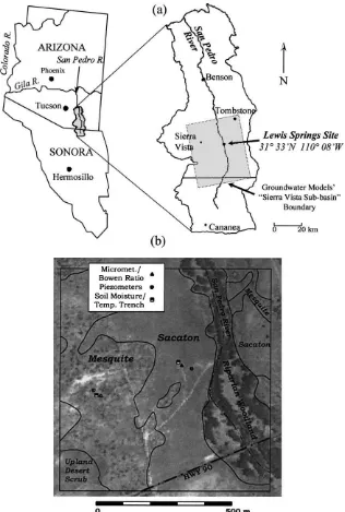
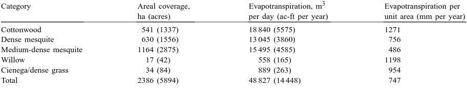
The Upper San Pedro River Basin in southeast-ern Arizona and northsoutheast-ern Sonora, Mexico (Fig. 1a) is an ideal area in which to investigate these poorly understood processes of regional aquifer water bal-ance. Unlike many riparian systems that have been disrupted due to the lowering of the groundwater table by pumping, the basin has a lengthy reach of intact perennial flow, which sustains a relatively lush riparian corridor vegetation (Grantham, 1996). From previous observation and modeling studies, three dominant components of the basin’s natural ground-water system have emerged. These three components — mountain front recharge, surface water discharge, and water uptake by riparian vegetation — are esti-mated to be of similar magnitude (Corell et al., 1996; Vionnet and Maddock, 1992).
It is widely believed that the presence of large-scale groundwater pumping in the nearby urban areas of Sierra Vista and Fort Huachuca has created a cone of depression which has, or will soon, diminish the baseflows in the river. The disruption of riparian cor-ridor ecology due to groundwater depletion has been well documented throughout this region (Stromberg, 1993a,b; Grantham, 1996). Numerous groundwater modeling and conceptual studies have been per-formed for various sub-basins of the San Pedro. All of them include the “Sierra Vista sub-basin” (see Fig. 1a), the area of principal concern due to the larger amount of pumping therein (Kreager-Rovey, 1974; Freethey, 1982; Rovey, 1989; Vionnet and Maddock, 1992; Corell et al., 1996). The latest groundwater model of the Sierra Vista sub-basin was developed by the Arizona Department of Water Resources (Corell et al., 1996). This model estimates a pre-1940 steady-state mountain front recharge of 63 769 m3 per day (18 870 ac-ft per year) and an annual ground-water baseflow discharge to the stream of 32 206 m3
per day (9530 ac-ft per year). With these major in-puts and outin-puts they calculate an evapotranspiration rate of 26 697 m3 per day (7900 ac-ft per year) by matching observed baseflows and well hydrographs. Riparian consumptive use in the model is assumed to be that portion of riparian vegetation water use withdrawn strictly from the saturated zone. For their 1940–1990 transient run water balance, Corell et al. (1996) report a mountain front recharge of 64 209 m3 per day (19 000 ac-ft per year), a baseflow discharge of 24 213 m3per day (7165 ac-ft per year), and an av-erage well extraction of 30 317 m3per day (8971 ac-ft per year). This “post-development” simulation re-sulted in an evapotranspiration rate of 25 524 m3per day (7553 ac-ft per year). This value of 25 524 m3per day (7553 ac-ft per year) matches well with an esti-mate of 26 021 m3per day (7700 ac-ft per year) based on an analysis of stream flow records, which esti-mated ET by using the difference between estiesti-mated baseflow in winter and summer.
These latest model simulations and conceptual estimates (Corell et al., 1996) of riparian vegetation water use from the water table compare well with the Vionnet and Maddock’s (1992) previous modeling es-timate of 26 690 m3per day (7898 ac-ft per year) but
Table 1
Riparian vegetation categories and associated water use in the Sierra Vista sub-watershed of the San Pedro River Basin reported by ADWR (1991).
Category Areal coverage,
ha (acres)
Evapotranspiration, m3
per day (ac-ft per year)
Evapotranspiration per unit area (mm per year)
Cottonwood 541 (1337) 18 840 (5575) 1271
Dense mesquite 630 (1556) 13 045 (3860) 756
Medium-dense mesquite 1164 (2875) 15 495 (4585) 486
Willow 17 (42) 558 (165) 1198
Cienega/dense grass 34 (84) 889 (263) 954
Total 2386 (5894) 48 827 (14 448) 747
that this estimate for total riparian corridor water use does not distinguish between vegetation water use that is derived solely from groundwater and that which comes from other sources such as recent precipitation and river bank flooding. This points to an important distinction that we will try to address herein, namely, the importance of estimating both the quantity and the source for riparian evapotranspiration in order to delineate the transpired water which is a part of the groundwater budget.
In many areas within the Sierra Vista sub-basin, the riparian corridor is composed mainly of three natu-ral vegetation groupings. A dense canopy of tall cot-tonwood and willow trees (Populus fremontii, Salix
gooddingii, and Baccaris glutinosa) is crowded near
the banks established by primary and secondary chan-nels of the river. Beyond this forest canopy lies a broad floodplain (∼100–500 m wide laterally) covered prin-cipally by a perennial floodplain bunchgrass called giant sacaton (Sporobolus wrightii). Finally, between the sacaton and the upper benches beyond the riparian area lies a community composed mainly of mesquite trees (Prosopis velutina), although the mesquites in this area are interspersed with several other woody shrubs and grasses. The objective of our study was to use micrometeorological techniques to quantify the water use of the sacaton and mesquite areas of the riparian corridor over the course of several seasons; this being the time scale relevant to groundwater mod-els. By doing so, we hoped to better understand two of the three commonly encountered vegetation group-ings in the San Pedro riparian corridor. Additionally, we monitored the status of the soil moisture and the water table elevation underneath these areas to help identify the source of the evaporated water. Numerous observations indicate that the sacaton and the mesquite
are deep rooted; thus, they have been thought to rely mainly on water taken up from the near-surface water table when they exist in riparian corridors. The cot-tonwood/willow gallery is the subject of other obser-vational studies (e.g., Qi et al., 1998; Schaeffer et al., 2000; Goodrich et al., 2000).
2. Background
2.1. Study sites
Two vegetation study areas nearby Lewis Springs on the San Pedro River floodplain in southeastern Arizona, USA were chosen as the field sites for this study. A location map is given in Fig. 1a. The study sites are located approximately 30 km southwest of Tombstone, AZ and 20 km east of Sierra Vista, AZ. The climate of the upper San Pedro valley is semi-arid with temperatures ranging from a mean maximum temperature of 24.8◦C to a mean minimum tempera-ture of 9.9◦C (1960–1990 averages recorded in Tomb-stone). The precipitation distribution is bimodal with about 60% of the rainfall occurring during the sum-mer monsoon months of July–September and 23% occurring in the winter months of December–March. The annual average precipitation is 343 mm at Tomb-stone though rainfall in this area has a high spatial and temporal variability.
whitethorn acacia (Acacia constricta), cat-claw acacia (Acacia greggii) and Mormon tea (Ephedra spp.). The other monitoring site was established in the sacaton grass-dominated lower portion of the floodplain, be-tween the mesquite area and the cottonwood/willow tree gallery immediately adjacent to the river (Fig. 1b). This site was mainly composed of∼1 m high sacaton bunchgrass, but a few smaller mesquite shrubs, to-bosa grass (Hilaria mutica), and vine-mesquite grass (Panicum obtusum) also existed within this vegeta-tion area. The percent vegetavegeta-tion cover and species composition for the mesquite and sacaton areas were estimated from a 3 m thermal-IR image taken in 1997. The areal coverage within a 50 m radius of the sacaton tower was classified as about 80% sacaton, 10% shrub, and 10% bare soil. The coverage nearby the mesquite tower consisted of about 50% mesquite, 20% shrub, 20% grass, and 10% bare soil cover. While the mesquite area is not as dense or homogeneous as the typical mesquite bosque (or forest) found in other areas of the Southwest, it was representative of the other mesquite areas within the Upper San Pedro.
2.2. Methods
In 1996, we established one 10-m-high meteorolog-ical tower at each of the two study sites. These towers were equipped with a set of standard meteorological instruments to measure the air temperature, relative humidity, incoming solar radiation, air pressure, wind speed, wind direction, and precipitation. The measure-ments were sampled every 10 s and an average value recorded every 20 min. Additionally, the towers were equipped with instruments to measure the available energy (net radiation−ground heat flux) and Bowen ratio, β, the ratio of sensible heat flux to latent heat flux. By measuring the difference in air temperature,
1T (◦C), and vapor pressure, 1e (kPa) under grass and the one under bare soil at two levels above the ground, the Bowen ratio was calculated from
β =γ1T
1e (1)
where γ is the psychrometric constant (kPa◦C−1). With this technique the amount of energy that is con-sumed at the land surface by the evaporation of water can be determined. The total latent heat flux,λE, was then calculated from
λE= Rn−G
1+β (2)
where Rn is the net radiation at the land surface
(W m−2), andGis the ground heat flux (W m−2). Energy balance Bowen ratio (EBBR) systems (orig-inally designed by Campbell Scientific, Logan, UT1) were deployed over both sites. In the sacaton grass-land, temperature and humidity were measured at 2.1 and 5.6 m above the ground, while over the mesquite site, the height of the two levels were 5.9 and 10.0 m. Air was ducted continuously from the two heights into 2 l, polyethylene buffer bottles; vapor pressure mea-surements were made every second from air that was sampled, alternating every 2 min, from these two bot-tles. These values were averaged and recorded every 20 min. Air temperature measurements were made ev-ery second with 75-mm diameter, chromel–constantan thermocouples located at each height and a 20-min av-erage was recorded. Net radiation was measured with Q7.1 net radiometers (REBS, WA) installed on sepa-rate tripods just south of the met towers at 4 m above a surface of grass and bare soil at the sacaton site and at 4.7 m above a partial covering of mesquite, grass and bare soil at the mesquite site. Soil heat flux at each site was obtained as an average of two measure-ments using soil heat flux plates (REBS, WA) buried 0.08 m below grass and bare soil. The soil temperature above the heat flux plates was found by averaging soil thermocouple measurements made at 0.02 and 0.06 m above the heat flux plates. The soil heat flux at the surface was then calculated by adding the measured heat flux at 0.08 m to the change in energy stored in the layer above the heat flux plates (0–0.08 m), which is proportional to the rate of change of soil temper-ature measured by the soil thermocouples (Campbell Scientific, 1991).
Numerous difficulties have been reported (Nichols, 1992; Unland et al., 1996, 1998) when deploying this particular type of EBBR system in arid conditions. In this study, problems resulted from: (1) using the pro-prietary chilled-mirror, dew-point hygrometer to mea-sure vapor presmea-sure in arid environments; (2) leaks in the tubing, buffer bottles and connectors of the duct-ing system that is used to brduct-ing air from two different levels to the vapor pressure measuring device; and (3)
1 The use of this and other commercial names in the paper is
condensation inside the tubing of the ducting system. To avoid difficulties with the dew-point hygrometer encountering conditions outside of its operating range and occasional ice formation on the mirror, we in-stalled a more dependable HMP35D temperature/RH probe (Vaisala, Woburn, MA) to measure vapor pres-sure in the air ducted from the two different levels. Tests showed a good agreement between this probe and the hygrometer when both instruments were func-tioning within normal operating range. Cellier and Olioso (1993), who tested similar modifications for an EBBR system confirm our modifications. To insure that the ducting system was operating correctly, reg-ular pressure tests were made at least every 2 months to check for leaks in the ducting. On numerous oc-casions, except for the warmest, driest months of the year, condensation occurred inside the tubing used for ducting the air to the humidity sensor. This prob-lem resulted in a span of erroneous data (for about 1–4 h, depending on its severity) after daybreak and was caused by the outside air temperature (and con-sequently, the dew point temperature) rising rapidly at dawn while the temperature rise inside the ducting lagged behind due to the thermal inertia of the duct-ing. Thus, air with a higher dew point was imported into a cooler environment and condensation could oc-cur. This condensation happened almost daily, except for the driest months of April, May and June, and was detected during data processing by examining both the inside and outside vapor pressure measurements. Condensation was indicated by a rapid rise and fall in the vapor pressure of the air ducted from one of the Bowen ratio intakes which was coincident with a dif-ference between the vapor pressure measured with the Bowen ratio system and that measured with a separate humidity probe. Return to acceptable Bowen ratio measurements was diagnosed by the internal vapor pressure once again tracking the outside measurement. While this operation did not “solve” the condensation problem, it was extremely helpful in determining pe-riods of erroneous data. Additionally, fluxes were not computed when the measured Bowen ratio was close to−1, specifically for the range−0.4 > β >−1.6. This condition occurs routinely for short morning or evening periods when the energy for evaporation is low, sensible and latent heat fluxes are in opposite di-rections and approximately equal, and the Bowen ratio method cannot determine the magnitude of the fluxes.
In order to compare the results of this study with a reference evaporation rate that can be computed with standard meteorological data alone, we computed the reference crop evaporation rate,Erc(Shuttleworth,
1993). The reference crop evaporation is an estimate of the evaporation, which would occur from a short, well-watered grass with a fixed-height of 0.12 m, an albedo of 0.23 and a surface resistance of 69 s m−1. It is calculated in units of mm per day by the following formula:
whereRn is the net radiation exchange for the crop
cover (mm per day),Gthe soil heat flux (mm per day),
T the air temperature (◦C),U2the wind speed at 2 m
(m s−1),Dthe vapor pressure deficit (kPa),∆the slope of the saturation vapor pressure versus temperature curve,γ the psychrometric constant (kPa◦C−1), and
γ∗is a modified psychrometric constant (kPa◦C−1). The evaporation rate from a well-watered crop or vegetation community can differ from that of a refer-ence crop of well-watered grass. Typical differrefer-ences are ±10–20% (Shuttleworth, 1993). We present this reference crop evaporation as a first order estimate of the evaporation that might have occurred from the cot-tonwood/willow riparian forest. Evaporation from the riparian forest would possibly differ from the reference crop due to differences in canopy architecture (e.g., roughness and height), available energy (e.g., lateral advection of energy, shading of canopy understorey), water availability and boundary layer differences be-tween the atmosphere and leaf surfaces, etc.
manually approximately every 2 weeks, but hourly measurements were made on some days to quantify diurnal variations.
2.3. Measurement accuracy and representativeness
2.3.1. Energy balance Bowen ratio measurements
EBBR measurements are prone to both random and systematic errors. Random errors are likely to be small when averaged in the cumulative flux values reported in this study. Systematic errors in the EBBR measure-ments can result from errors in the net radiation, soil heat flux, and in the measurement of the Bowen ratio. Both the net radiometers used in this study were calibrated against a standard, four component Kipp and Zonen net radiometer (CNR 1, SCI-TEC Instru-ments, Canada) to within an average root mean square error of 8 W m−2. Eighty percent of the upward con-tribution to net radiation comes from a circular region, 18.8 m in diameter, directly below the radiometer at the mesquite site and from a 16 m diameter circle at the sacaton site (L. Hipps, pers. commun.). We estimate that systematic errors in net radiation are pessimistically, 15%, and optimistically, 5%.
The soil heat flux is likely to be highly variable and is poorly sampled by a single heat flux plate under grass and a second under bare soil. However, sam-pling under grass and under bare soil will capture the extreme values of soil heat flux. These two measure-ments differed by as much as a factor of 2, depending on the time of day and season. Thus, we estimate errors in soil heat flux as pessimistically, 50%, and optimistically, 20%.
Errors in the Bowen ratio measurement vary, de-pending on the surface conditions. Temperature gra-dients are normally large and easily measured with the separation between measurement levels used in this study. When the daytime Bowen ratio is small, vapor pressure gradients are more pronounced and thus easily measured. However, when the vegetation is inactive and little water is being evaporated, the va-por pressure gradient is very small, so small that the gradient can be less than the resolution of the temper-ature/RH probe. However, the computed latent heat flux is small under these conditions and contributes little to the cumulative latent heat flux. Given the un-certainties in the net radiation, the ground heat flux
and the Bowen ratio, we estimate systematic errors in the computed latent and sensible heat fluxes to be pessimistically,±30%, and optimistically,±10%.
The micrometeorological approach used to measure evaporation in this study can only realistically provide measurements representative of a particular type of vegetation cover when there is a reasonably extensive, uniform area of that vegetation immediately upwind of the instruments. Thus, using micrometeorological techniques requires some knowledge of the flux foot-print (i.e., the source area for the signal measured at the sensor). Horst (1999) points out that defining a flux footprint for the Bowen ratio technique is only possible in limited circumstances. Regardless, we used a sim-plified approach suggested by Schuepp et al. (1990, 1992) to estimate the source area for the measured fluxes. Assuming the roughness length, z0 = 0.1hv,
and the zero plane displacement height,d =0.75hv,
where hv is the average vegetation height equal to
3.4 m for mesquite and 0.75 m for sacaton. Assuming a typical daytime value for the sensible heat flux of 300 W m−2 and an air temperature of 30◦C, for the mesquite tower, 80% of the measured (latent or sensi-ble) heat flux is calculated to originate within 30, 84, 148, and 212 m of the tower for wind speeds of 1, 2, 3, and 4 m s−1, respectively. Similarly, 80% of the flux measured at the sacaton tower is calculated to origi-nate within 23, 64, 114, and 165 m of the tower for wind speeds of 1, 2, 3, and 4 m s−1, respectively.
time during which measurements were made. Only 7% of the EBBR measurements were recorded when wind speeds at 10 m height were in excess of 3 m s−1 with wind direction between 225◦and 315◦. In the fol-lowing, we therefore assume that the reported fluxes are in conditions with reasonably adequate fetch.
2.3.2. Soil moisture measurements
A combination of different techniques was used to calculate volumetric water content from the WCR fre-quency. First, an in situ calibration was made during installation where the probe period (inverse of fre-quency) was related to volumetric soil water content measured from gravimetric water content and bulk density samples taken at each probe depth. This in-formation was used to modify Campbell Scientific’s recommended calibration polynomial to best match data collected from the installation. Probe-computed water content was also corrected for temperature fluctuations in the soil following the recommended correction provided by the manufacturer. Periodic soil auger gravimetric water content measurements, along with the bulk density measurements made dur-ing the trench excavations, were made throughout the year to verify the probe calibration. These subsequent auger measurements indicated that a simple, one-time adjustment (an offset of ±0.02–0.07 m3m−3 added to the computed water content) was needed at most levels to minimize the difference between auger mea-surements and probe computed water content. It was difficult to get a good match using these methods, but a laboratory calibration using the site specific soils resulted in a calibration curve, which performed worse than the in situ technique reported here. We suspect that the calibration difficulties arose due to vertical soil heterogeneity in the profile (we used the same polynomial for each of the levels in the profile), probe-specific contact between the probe rods and the soil, and sampling errors in the bulk density and gravi-metric measurements made from the auger. Given these difficulties, the WCR measurements reported later in this paper should be viewed more as an indi-cator of relative changes in water content rather than an absolute ones — keeping in mind that the measure-ment error might be as large as 0.03–0.10 m3m−3for a given probe.
Due to cost limitations, only one 0.3 m probe was used to sample at each depth under each site, and
this restricts the representativeness of the soil mois-ture measurements. Trench excavations revealed that the soil at each site was quite homogeneous in the horizontal plane, but significant layering of sand and gravel was observed at the mesquite site. In spite of the uncertainty, the qualitative picture of the mois-ture redistribution process given by the probes under each site suggests that our soil moisture sampling is fairly accurate, and we assume this in the subsequent analysis.
We have collected data from both sites from 1996 to 1998. However in this paper, most of the data that we will present were collected from March 13, 1997 to March 13, 1998. We focus on this time period to present the water use characteristics of the two sites over the course of a full annual cycle when we had relatively complete Bowen ratio and vadose zone monitoring. Bowen ratio data collected prior to this period were not used because they may have been prone to error due to leaks in the ducting system. In June 1998, the sacaton site was completely burned due to a wildfire and monitoring was discontinued thereafter. For the mesquite site, EBBR monitoring continued till November 1998, but much of the data collected during the monsoon period was invalid due to equipment malfunctioning. We will, however, present additional soil moisture and precipitation data from the mesquite site from March 1997 to November 1998 to demonstrate the vadose zone dynamics under the rainier conditions of 1998.
3. Results
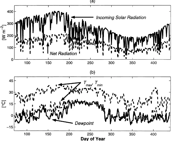
Fig. 2. (a) Average daily incoming solar (solid line) and net (dashed line) radiation (W m−2). (b) Average daily dew point (solid line) along with daily minimum and maximum air temperature (dashed lines) (◦C) at 5 m height for the period of March 1997–1998 at the mesquite site. For Figs. 2–5, a value of 365 was added to the days of the year in 1998.
Fig. 3. Cumulative precipitation and evapotranspiration from the sacaton and mesquite sites for the period of March 1997–1998. Periods of missing data, where the cumulative water use was extrapolated, are indicated by an “×”.
July prior to the onset of the monsoon season. The arrival of the rainier monsoon was around July 19, 1997 (DOY 200), where the increase in dew point temperature was evidence of the increase in moisture over the region. The riparian valley itself received cold air drainage from the uplands and was substan-tially colder than other areas in the valley at night. In 1997, nocturnal freezes occurred in the springtime till April 26 (DOY 116) and the first freeze of fall was October 12 (DOY 285). For reference, the first freeze of autumn was October 23 in 1996 and Oc-tober 6 in 1998. The last springtime freeze in 1998 was May 15. We will show later that these freeze dates seem to bound the transpiration activity of the mesquites.
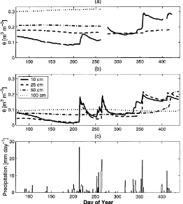
Fig. 4. Volumetric soil moisture under the (a) sacaton and (b) mesquite sites measured at 0.1, 0.25, 0.5 and 1.0 m depth along with the (c) daily precipitation for the period of March 1997–1998. In Fig. 4a, the probes at 0.5 and 1.0 m no longer functioned after DOY 260 and no data was recorded after DOY 421.
and the Bowen ratio is close to−1, and also during those hours when condensation occurred (see Section 2.2). A total of about 12% of the measurements, or on average, about 3 h per day were estimated by in-terpolation. There were also occasional gaps in the record due to equipment malfunctions. These periods of missing record were filled by using the daily avail-able energy from the alternate tower multiplied by the average evaporative fraction (= λE/(Rn−G))
at the site of interest calculated a period of equal record length prior to equipment malfunction. In other words, we assumed that the evaporative fraction did not change significantly during these unmeasured times. For example, if 2 days of data were missing, we assumed that the evaporation rate for each day in the missing period was equal to the daily available energy (measured at the other site) multiplied by the
average evaporative fraction from the previous 2 days. Fortunately, these missing periods were often brief. They are indicated in Fig. 3 by an “×” on the solid line.
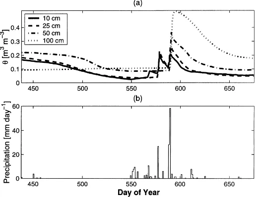
Fig. 5. (a) Average daily volumetric soil moisture,θ(m3m−3) at 0.1, 0.25, 0.50 and 1.0 m depth under the mesquite site for the extended period of March 1998–November 1998. (b) Total daily precipitation (mm) at the site during this same period. The wetter winter and summer rainfall of 1998 (as compared to 1997) led to considerably deeper vadose zone recharge under this site.
and began to take up water. This activity continued throughout late summer and then tapered off during the drier and colder months of October and November (DOY 270–330). For the mesquite site, total evapora-tion was less dependent on recent precipitaevapora-tion. The mesquite trees leafed out after the last nighttime freeze of spring on April 26, 1997 (DOY 116) and then tran-spired at a fairly constant rate throughout the growing season. The mesquite evaporation rate fell rapidly immediately following the first freeze of autumn on October 12 (DOY 285), thus providing indirect ev-idence that mesquite leaves cannot tolerate freezing conditions.
For the pre-monsoon period of May 15–June 30 (DOY 135–181), the average evaporation rate for the mesquite site was 1.6 mm per day, compared to 0.3 mm per day for the sacaton site and 7.3 mm per day for the reference crop evaporation (not shown in Fig. 3). For the monsoon period of August 1–September 15 (DOY 213–258), the average evaporation rate for the mesquite site rose to 2.4 mm per day (sacaton
=1.6 mm per day; reference crop=5.0 mm per day). At the mesquite site, the 1.6 mm per day pre-monsoon rate is largely indicative of the mesquite transpiration alone, and the jump to 2.4 mm per day
during the monsoon most likely reflects the added contribution of bare soil evaporation along with addi-tional transpiration from the grasses and small shrubs, which greened up with the increased, near-surface soil moisture. The increase seen at the sacaton site from the pre-monsoon to monsoon period is simply a matter of the grass becoming active. The winter-time evaporation is higher from the sacaton site than at the mesquite site when the vegetation was senes-cent. This is arguably because the sacaton area has more clayey, less well-drained soils relative to the mesquite area leading to higher soil evaporation. The reference crop evaporation rate far exceeds that of the mesquite and the grass; on a weekly average basis, it is about four times higher than the mesquite rate during the dry, pre-monsoon period and decreases to about twice the magnitude during the monsoon. This implies that the mesquites (or at least, some of them) are water-limited throughout the year, though never as much as the sacaton.
of March 1997–1998. The probes at 0.5 m and deeper under the sacaton failed to operate after DOY 260 due to electrical damage caused by a nearby lightning strike. For the entire monitoring period, no measur-able changes were indicated at a depth of 2 m in the mesquite profile nor at the depth of 1.5 m under the sacaton. Two very different behaviors between the sites are apparent. For the sacaton profile, where the vadose zone is composed of a fairly homogeneous silty-clay to clay textured soil, there was a general increase in soil moisture with depth to the water ta-ble, located around 3 m below ground surface. The low permeability soil appears to prevent rainfall from penetrating to depth and almost all of the significant changes in soil moisture happened within the upper 0.25 m of the soil profile. For the mesquite profile, the vadose zone is composed of loamy/sandy-loam textured soils interspersed with thin gravel lenses. Consequently, rainfall penetrated farther into the soil column than at the sacaton site. Moreover, the nearly uniform soil moisture with depth suggests that the profile was fairly well drained. At this site, the wa-ter table was at∼10 m depth. While the soil column shows very little change of soil moisture at 0.5 m and below during the summer rains, Fig. 4b begins to show that soil wetting penetrated to greater depth during the winter rains, and this may serve as a moisture source for mesquite transpiration during the subsequent dry season.
Fig. 5a and b is an extension of the soil moisture and precipitation time series shown in Fig. 4b and c, into the period of March–November 1998 at the mesquite site. We note that the scale for soil moisture and precipitation has been expanded in this figure to accommodate the higher values of soil moisture and daily precipitation observed during this time period. During this comparatively wetter year, recharge oc-curred at greater depths into the profile. The profile was wetter in the springtime and the decrease seen at 0.5 m around May 15, 1998 (DOY 500) coincides with the leafing out of the mesquite and the greening up of smaller shrubs and grasses that happened at this time. Also, Fig. 5a shows the first and only time dur-ing our monitordur-ing that we observed deeper, vadose zone recharge. Significant wetting down past 1.0 m occurred after receiving more than 58 mm of rain on August 12 (DOY 589), a day which was preceded by a 28 mm rainfall event.
4. Discussion
The measured, cumulative evaporation and precip-itation shown in Fig. 3 provides compelling evidence that the sacaton at the study site relied on recent pre-cipitation as its principle source of water. Although sacaton roots were observed to extend to depths greater than 2 m during trench excavation, these deeper roots did not appear to extract water of any significant ex-tent. Indeed, the grass became active only after water from monsoon rainfall had substantially moistened the surface soil layer. During the drier, hotter months of April, May, June, and the first half of July 1997, most of the grass near the tower was almost completely inactive, with only a few sparse green shoots inter-spersed in the large clumps of dry grass. Moreover, sacaton evaporation is seen to increase immediately af-ter precipitation events and then decrease between the inter-storm periods of the monsoon (DOY 200–300, Fig. 3). This behavior provides additional evidence that the sacaton responds to surface soil moisture, and does not access significant quantities of groundwater. As a caveat to the hypothesis that the sacaton is non-phreatophytic in nature, we note that sacaton in the floodplain within about 10–20 m of the river-bank was noticeably greener during the dry season. Although the water table in this region might only be 0.5–1 m closer to the surface, it appeared that the sacaton located in this limited area were functioning as phreatophytes. One possible reason for this might be that the water table was slightly closer to the sur-face in this region. However, a second explanation is that the greener area was more for about 3 or 4 h in the morning and that the air is perhaps more humid due to the presence of the nearby, tall forest gallery (see Fig. 1b). Further evidence that the near-riverbank sacaton acts differently was apparent in June 1998, when a fire burned the entire sacaton area. Within weeks of this event (and before any monsoon mois-ture had arrived), new green shoots were already sprouting vigorously from the sacaton located within about 20 m of the riverbank. Further away from the bank, re-growth was less noticeable.
Assuming negligible runoff from this level site, the sum of the evaporation and the change in soil mois-ture storage should equal the total precipitation. The total sacaton evaporation during the study period was 272 mm, and the change in soil moisture stor-age was +30 mm based on before- and after-study soil auger gravimetric measurements multiplied by a depth-dependent bulk density (sampled during trench excavations) and an effective depth. The basic error in the water balance is therefore 22%. However, pre-cipitation gages are prone to under-catch due to local wind field effects, and tipping bucket gages may have difficulty in measuring all the precipitation in high intensity storms. Making a conservative 5% correc-tion to the total precipitacorrec-tion, the water balance error is around 16%, consistent with our error estimate in Section 2.3.
The mesquite site had a markedly different water use than the sacaton. In this case, the cumulative total evaporation shown in Fig. 3 suggests a water use that is more closely tied to available energy than recent rainfall in frost-free periods. Thus, it appeared that mesquites obtain water from deeper in the soil column. For some days in the middle of the growing season, water table levels below the mesquite were measured on an hourly basis. If mesquites obtain water from the saturated zone, cyclical, diurnal fluctuations should occur in the water table elevation: numerous studies have reported such a phenomenon under phreatophytes (e.g., Todd, 1959; Gatewood et al., 1950; Tromble, 1972). However, we did not detect diurnal changes in water level of the piezometer at the mesquite site. This suggests that either the trees were obtaining water from the deeper (2–10 m) vadose zone rather than from the saturated zone, or alternatively, that the mesquites’ wa-ter uptake from the saturated zone might not have been large enough to affect the water levels at the piezome-ter. We can assume that the pre-monsoon evaporation rate for the mesquite site was primarily representative of the more mature, deep-rooted mesquite trees alone since they were the only visibly active plants at the site. With this assumption, an average rate of about 1.6 mm per day is a conservative estimate of mesquite water use from deeper in the vadose zone and/or from the capillary fringe at our site.
The fact that the cumulative total mesquite evap-oration loss of 374 mm is close to the 343 mm annual-average precipitation at nearby Tombstone,
AZ might be further evidence that the mesquite com-munity as a whole does not withdraw much water from the water table. Arguably, if the mesquites relied solely upon the deep vadose zone soil moisture, the average-annual mesquite water use is expected to be equivalent to the long-term average precipitation (but not necessarily the precipitation total in any 1 year). Moreover, the evaporation rate for the mesquite site in this study is, for instance, vastly different from that measured at a mesquite thicket located along the Upper Santa Cruz River of Arizona (Unland et al., 1998). Unland et al. (1998) report a consumptive wa-ter use of 848 mm per year in 1995, which is more than twice that measured at our site. While both measurements were made over vegetation composed primarily of mesquite trees, the Santa Cruz site had taller and denser canopy. Additionally, the water table was closer to the surface (1–2 m) at the Santa Cruz site, and occasionally the site was flooded.
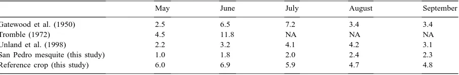
Finally, we compare our summer, monthly average ET from the mesquite community with several aver-age values reported in the literature. Table 2 shows the average total evaporation between May and Septem-ber in comparison with values from previous studies of the water use of mesquite in southern Arizona. Specif-ically, the three other studies were:
1. a study of mesquite (100% cover) growing in large tanks (Gatewood et al., 1950),
2. a water balance study for a mesquite bosque (80% cover) growing over a small confined aquifer (Tromble, 1972),
3. a micrometeorological study using an EBBR sys-tem over a mesquite bosque (∼80% cover) (Unland et al., 1998).
Table 2
San Pedro average monthly values for mesquite evapotranspiration and reference crop evaporation versus other studies (mm per day).
May June July August September
Gatewood et al. (1950) 2.5 6.5 7.2 3.4 3.4
Tromble (1972) 4.5 11.8 NA NA NA
Unland et al. (1998) 2.2 3.2 4.1 4.2 3.1
San Pedro mesquite (this study) 1.0 1.8 2.0 2.4 2.3
Reference crop (this study) 6.0 6.9 5.9 4.7 4.8
determined by the depth to groundwater, which at our mesquite site was much deeper (around 10 m). For ex-ample, the mesquite canopy cover at the Santa Cruz site (Unland et al., 1998) had an areal density of around 80%, whereas our mesquite site was estimated to be 50%, the difference between the sites being a factor of 1.6. During the dry months of May and June when it was likely that only the deeper-rooted mesquite trees were active, Table 2 shows that our site differs from the Santa Cruz site by a factor of 2.2 (May) and 1.8 (June). However, we would not expect the transfor-mation of an evaporation rate from an area with 50% cover to one with 80% cover to be linear since sig-nificant in-canopy feedbacks exist that would tend to reduce the evaporation per unit leaf area as the density increased.
At this stage in our study, we are not yet able to quantify the groundwater use of the riparian vegeta-tion as a whole. Such an estimate will largely depend on an adequate estimation of the water use for the cottonwood/willow gallery. Also, it will be important to delineate the depth to groundwater of the different mesquite stands in the Upper San Pedro (or the density of the stand, which is a likely consequence of the wa-ter table depth), since our comparison suggests that the amount of groundwater they use varies accordingly. The vegetation classification and associated water use given by ADWR, 1991 in Table 1 estimates a water use of 1271 mm per year for the cottonwood. For 1997, the transpiration activity of the riparian cottonwood and willow trees lasted approximately from mid-April to mid-October (DOY 110–285). Our reference crop estimate for this period is 982 mm. The ADWR classi-fication did not delineate sacaton areas explicitly. For their “medium-dense mesquite” classification they ap-plied a rate of 486 mm per year, while our measured yearly total was 374 mm per year. Our results suggest that much of this total is not derived from the saturated
zone; thus, it might be appropriate to omit this category from a tally of total riparian vegetation groundwater use. If total water use were revised accordingly, the to-tal evaporation would be 33 332 m3per day, which is closer to the model estimates of about 26 000 m3per day (Corell et al., 1996; Vionnet and Maddock, 1992). Yet, it is important to re-emphasize that the ADWR estimates of dense-mesquite and cottonwood/willow evaporation need to be confirmed by future studies.
5. Conclusions
fringe. These results based on the evolution of cu-mulative precipitation, cucu-mulative evapotranspiration and soil moisture measurements indicate that much of the vegetation in these two areas of the riparian corri-dor are not using groundwater. Consequently, the two areas together used less groundwater than previously assumed. The results of this study suggest that, in order to estimate the groundwater use from riparian vegetation from the total riparian corridor in the Upper San Pedro, efforts should be concentrated principally on estimating the water use from obligate phreato-phytes. The obligate phreatophytes are likely confined to the narrow, gallery forest immediately adjacent to the river, which is dominated by the cottonwood and willow trees, and to areas of dense mesquite stands.
Acknowledgements
Principal financial support for this research has been provided by the EPA STAR Graduate Student Fellowship Program, the USDA-ARS Global Change Research Program, NASA Grant W-18997 provided to the Department of Hydrology at the University of Arizona, and the Arizona Department of Water Resources. This work was partially sponsored and benefited greatly from the SALSA Program. We graciously thank Mr. Carl Unkrich, USDA-ARS, in providing the artistry for Fig. 1a and b. Additionally, we acknowledge and thank the Fort Huachuca Meteo-rological Support team, US Bureau of Land Manage-ment, and especially all the rest of the staff from the USDA-ARS located in Tucson and Tombstone, AZ.
References
ADWR, 1991. Hydrographic Survey Report for the San Pedro River Watershed. General Assessment, Vol. 1. Arizona Depart-ment of Water Resources. Filed with the Court, November 20, 1991, 604 pp.
Blaney, H.F., Criddle, W.D., 1950. Determining Water Require-ments in Irrigated Areas from Climatological and Irrigation Data. USDA (SCS) TP-96, 48 pp.
Campbell Scientific, 1991. Bowen Ratio Instrumentation Instruc-tion Manual. Campbell Scientific, Logan, UT, pp. 3–4. Cellier, P., Olioso, A., 1993. A simple system for automated
long-term Bowen ratio measurement. Agric. For. Meteorol. 66, 81– 92.
Corell, S.W., Corkhill, F., Lovvik, D., Putnam, F., 1996. A groundwater flow model of the Sierra Vista subwatershed of
the Upper San Pedro Basin — Southeastern Arizona. Modeling Report No. 10. Arizona Department of Water Resources, Hydrology Division, Phoenix, AZ, 107 pp.
Freethey, G.W., 1982. Hydrologic analysis of the Upper San Pedro Basin from the Mexico US Boundary to Fairbank, AZ. US Geological Survey Open-file Report 82-752.
Gatewood, J.S., Robinson, T.W., Colby, B.R., Hem, J.D., Halpenny, L.C., 1950. Use of water by bottom-land vegetation in the lower Safford Valley, Arizona. United States Geological Survey Water Supply Paper 1103.
Goodrich, D.C., Scott, R., Qi, J., Goff, B., Unkrich, C.L., Moran, M.S., Williams, D., Schaeffer, S., Snyder, K., Mac Nish, R., Maddock, T., Pool, D., Chehbouni, A., Cooper, D.I., Eichinger, W.E., Shuttleworth, W.J., Kerr, Y., Marsett, R., Ni, W., 2000. Seasonal estimates of riparian evapotranspiration using remote and in situ measurements. Agric. For. Meteorol. 105, 281–309.
Grantham, C., 1996. An assessment of the ecological impacts of ground water overdraft on wetlands and riparian areas in the United States. United States Environmental Protection Agency. EPA 813-S-96-001, 103 pp.
Horst, T.W., 1999.. The footprint for estimation of atmosphere– surface exchange fluxes by profile techniques. Boundary-Layer Meteorol. 90, 171–188.
Kreager-Rovey, C., 1974. Numerical model of flow in a stream-aquifer system. Hydrology Paper No. 74. Colorado State University, CO.
Nichols, W.D., 1992. Energy budgets and resistances to energy transport in sparsely vegetated rangeland. Agric. For. Meteorol. 60, 221–247.
Odum, E.P., 1971. Fundamentals of Ecology, 3rd Edition. Saunders, Philadelphia, PA, 574 pp.
Qi, J., Moran, M.S., Goodrich, D.C., Marsett, R., Scott, R., Chehbouni, A., Schaeffer, S., Schieldge, J., Williams, D., Keefer, T., Cooper, D., Hipps, L., Eichinger, W., Ni, W., 1998. Estimation of evapotranspiration over the San Pedro riparian area with remote and in situ measurements. American Meteorological Society, Special Symposium on Hydrology, Phoenix, AZ, 11–16 January 1998. Session 1: Integrated observations of semi-arid land–surface–atmosphere interactions, Paper-P1.13.
Rovey, C., 1989. Hydrologic investigation of the Upper San Pedro Basin, Southeastern Arizona. Preliminary Report.
Schaeffer, S.M., Williams, D.G., Goodrich, D.C., 2000. Trans-piration of cottonwood/willow forest estimated from sap flux. Agric. For. Meteorol. 105, 257–270.
Schuepp, P.H., Leclerc, M.Y., MacPherson, J.I., Desjardins, R.L., 1990. Footprint prediction of scalar fluxes from analytical solutions of the diffusion equation. Boundary-Layer Meteorol. 50, 355–373.
Schuepp, P.H., MacPherson, J.I., Desjardins, R.L., 1992. Adjustment of footprint correction for airborne flux mapping over the FIFE site. J. Geophys. Res. 97, 18455–18466. Shuttleworth, W.J., 1993. Evaporation. In: Maidment, D.R.
Stromberg, J.C., 1993a. Riparian mesquite forests: a review of their ecology, threats, and recovery potential. J. Arizona–Nevada Acad. Sci. 27, 111–124.
Stromberg, J., 1993b. Fremont cottonwood–Goodding willow riparian forests: a review of their ecology, threats, and recovery potential. J. Arizona–Nevada Acad. Sci. 26, 97–110. Todd, D.K., 1959. Groundwater Hydrology. Wiley, New York. Tromble, J.M., 1972. Use of water by a riparian mesquite
community. In: Proceedings of the National Symposium on Watersheds in Transition. American Water Resources Association and Colorado State University, pp. 267– 270.
Unland, H.E., Houser, P.R., Shuttleworth, W.J., Yang, Z.L., 1996. Surface flux measurement and modeling at a semi-arid Sonoran Desert site. Agric. For. Meteorol. 82, 119–153.
Unland, H.E., Arain, A.M., Harlow, C., Houser, P.R., Garatuza-Payan, J., Scott, P., Sen, O.L., Shuttleworth, W.J., 1998. Evaporation from a riparian system in a semi-arid environment. Hydrol. Process. 12, 527–542.