3D MODELING OF HEADSTONES OF THE 2
NDAND 3
RDCENTURY
BY LOW COST PHOTOGRAMMETRIC TECHNIQUES
T. Landes a, M.-D. Waton b, E. Alby a, S. Gourvez a, B. Lopes a
a Photogrammetry and Geomatics Group, ICube Laboratory UMR 7357,
INSA Strasbourg, France
(tania.landes, emmanuel.alby, simon.gourvez, bastien.lopes)@insa-strasbourg.fr
b Service régional de l’Archéologie, DRAC, Alsace, France [email protected]
KEY WORDS: recording, photogrammetry, 3D modeling, texturing, laserscanning, assessment
ABSTRACT:
As a dozen headstones have been discovered during excavations in south Alsace, archaeologists stored them in the Regional Directorate of Cultural Affairs in Strasbourg. In order to complete the survey they are used to practice by hand on the steles, they asked the INSA Strasbourg to reconstruct at least the 7 figured sandstones in 3D. The high accuracy required by the archaeologists can be reached by an expensive technique using laserscanning system. Aim of the current work is to look for an alternative method and (if appropriate) low cost software allowing to provide a similar quality and a sufficient level of details. The 3D reconstruction of the headstones based exclusively on multiple images processing is presented. The step of point cloud generation is detailed because it determines the final product quality. Therefore, an assessment of the produced point cloud has been performed through comparison to a reference point cloud obtained by laser scanning technique. The steps leading to the photo-realistic textured 3D models of the headstones are presented and the software used for that are evaluated. The final product respects the accuracy requirement of 1 mm desired by the archaeologists.
1 . INTRODUCTION
In 2011, during the production of a cesspool in Niederhergheim - a little village in south Alsace – a construction company discovered several sandstone blocks. The diggers have then carefully excavated an area of about ten meters radius and discovered a series of headstones. These tombstones have been assigned by the archaeologists to the 2nd and 3rd centuries. The majority is realized in a sandstone containing inclusions of quartzite, except one of them, which is made in yellow sandstone and might come from a nearby village. The tombstones are currently stored in two cellars of the Regional Directorate of Cultural Affairs in Strasbourg. Archaeologists spent a lot of time by the study and analysis of these 13 sandstone blocks. They assume that they constitute together 7 figured tombstones. An excavation report has been drafted based on their visual collected observations. Crescent moons were discovered on several steles. This discovery doubles the number of crescent moons registered in Alsace. Due to the texture of some headstones or their state of conservation, sometimes only assumptions about the characters represented on the stele were made. Moreover, due to the weight of the blocks, their manipulation is almost impossible. In this context, a 3D photo-realistic model of every block of headstone seems to be the best solution. As virtual headstones, their manipulation as well as their surveying will be facilitated. Also some assumptions about the identification of some characters might in this way be confirmed.
A close collaboration between archaeologists and surveyors became obvious. The surveyors of INSA de Strasbourg have been involved in the project. The main difficulty is not only to define the acquisition and processing techniques to implement but also to define the most appropriate and useful model that
meets the requirements of the archaeologists. Archaeologists usually draw by hand the objects with basic measurement techniques. Also the use of photographs is a common solution but usually they are used without accurate rectification. A single headstone has been chosen as test headstone for the establishment of the most appropriate recording and processing chain.
2 . RELATED WORK
Today a large number of software and web services are available, even for non-specialists. Open source software can be used to generate quite easily point clouds, to mesh them and texture them. It seems possible to achieve and publish photo-realistic 3D models of objects, regardless of their size and type, taken from any digital camera. However the quality of the produced models and the performance of the software have only rarely been evaluated. These techniques can provide an alternative to laserscanning, which is a more expensive and not always more accurate technique (Alby & Grussenmeyer, 2012). (Kersten & Lindstaedt, 2012) investigated the potential of automatic 3D object reconstruction from multiple images by comparing several software packages and web services. They observed that the results from some software packages using digital cameras images are comparable to results obtained with expensive terrestrial laser scanners.
acquisition, the point cloud generation thanks to the camera position and image orientation calculations, the densification of the point cloud and the post-processing leading to the 3D mesh.
In this paper, the workflow leading from multiple images to 3D models of headstones will be explored. Low cost software will be considered, if possible, as an alternative to commercial software. The main step in the workflow is the 3D point cloud generation. Before going further into the process, the point cloud quality will be assessed as well as the software leading to it. After assessment, the next steps to consider will be mentioned and finally, the 3D models will be presented.
3 . POINT CLOUD GENERATION
The first question to answer concerns the survey method. The main specifications were the optimization of acquisition duration as well as the completeness and accuracy of the photographs per stele. The acquisition process is directly correlated to the tool chosen for orienting the digital images.
3.1 Acquisition
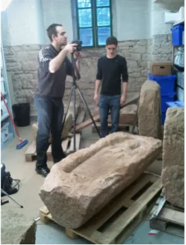
Photographs have been taken with a Canon EOS 5D Mark II camera, with a resolution of up to 21 megapixel. It is equipped with a CMOS sensor of very good quality (23.9 x 35.8 mm) and has rather low distortion (coefficients of the first order around 10-4). Two different objectives have been used (28mm for wide scenes and 50mm for closer shots). For improving the lighting conditions, several projectors have been installed around the steles.
Figure 1. Photogrammetric object recording of a headstone
In order to facilitate the orientation of the images by detection of homologous points, it was necessary to satisfy the condition that the same point should appear on at least three photographs. Moreover, in order to guaranty data quality, the base-to-height ratio has been kept in the interval 0.1 to 0.3.
At least, knowing that Photosynth (by Microsoft) will be tested for producing the point cloud, the angle between two successive photographs had to reach 15 degrees. The depth of field has been fixed to infinity.
3.2 Point cloud generation
The most important and difficult part of the processing chain was the point cloud generation. The state of the art and several experiments lead us to select several applications that seemed appropriate. Among those we have eliminated, there is 123D Catch (Autodesk), which, after a test, provided a very noisy and not dense enough point cloud. We suppose that it has to be related to the size of the stone blocks. A block of a headstone can reach about 2 m x 1 m and is therefore larger than architectural objects modeled in the study of (Kersten & Lindstaedt, 2012).
The open source software Photosynth (by Microsoft) solution coupled to PhotoSynth Toolkit (by H. Astre) seems to be the most appropriate tool for our needs and for the conditions of acquisition of steles. Introduced first by (Pomaska, 2009) for the purpose of generating relative oriented images and of allowing navigation in 3D, this application has been improved to generate also point clouds based on images. In order to check the quality of the produced point cloud, we compared the processing that it performs to that of a commercial and professional software (recognized and validated by the community of surveyors and photogrammetry), i.e. the PhotoModeler Scanner (Eos Systems) solution.
3.2.1 PhotoModeler Scanner tool: Using PhotoModeler Scanner for generating point clouds is certainly automated, but it requires user training, and is fairly complex for a novice, because -and this is rather an advantage- it enables the check of several steps during the process.
The main steps are (a) the automatic extraction of smartpoints; (b) image orientation; (c) scaling; (d) densification.
One limitation of the orientation step was the difficulty to process the whole dataset at once, although the 2012 version has been improved regarding this constraint (85% of the images against 53% in the previous version).
For ensuring the scaling, linear patterns have been arranged around the stele.
The densification operation is probably the less automated processing step. It is advised to select the appropriate pairs of images.
3.2.2 PhotoSynth and PhotoSynth Toolkit: Only a few steps require user intervention when using PhotoSynth. This is of course an advantage in terms of ease of use and processing time, but it arises the question of the generated product quality. The black box of this solution does not enable the mastering of the calculation operations. This disadvantage is hardly acceptable for scientific work. From the perspective of the user, the work begins first with the processing of images (in PhotoSynth), after transferring the data to the web service. (Pomaska, 2009) assumes that the software has been built from the Bundler core. PhotoSynth takes into account the EXIF (Exchangeable Image File) data and enables therefore the use of photographs taken with different cameras and focal lengths.
4 . ACCURACY ASSESSMENT
4.1 Process assessment
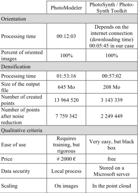
The processes realized by both solutions, PhotoSynth and PhotoModeler, have been compared based on qualitative criteria (ease of use, requirements for the acquisition) and quantitative criteria (time consumption, amount of created points). Results are reported in Table 2.
PhotoModeler PhotoSynth / Photo-Synth Toolkit
Orientation
Processing time 00:12:03
Depends on the internet connection (downloading time) 00:05:45 in our case Percent of oriented
images 100% 100%
Densification
Processing time 01:53:16 00:57:02 Size of the output
file 645 Mo 208 Mo
Number of created
points 13 964 520 3 143 339
Number of points after noise reduction
7 759 342 2 249 449
Qualitative criteria
Ease of use
Requires training, but
rigorous
Very easy, but black box
Price # 2000 € free
Data security Local process Stored on a Microsoft server
Scaling On images In the point cloud
Table 2. Comparison between PhotoModeler and PhotoSynth software
The number of created points is larger using PhotoModeler than PhotoSynth. However, the latter solution is more flexible when using images taken in different conditions and in random order. The scaling is more precise using PhotoModeler, because the digitizing is performed in the images whereas in PhotoSynth it is performed in the point cloud.
4.2. Point clouds assessment
For assessing the point clouds quality, both results have been compared to a reference point cloud, previously generated by the scanning of a stele with the FARO ScanArm instrument. The specifications of the system estimate the accuracy at 0.04 mm. The point cloud produced in this way contains 47 million points (Figure 3), but covers only the upper part of a stele. To lighten it and to reach a spatial resolution equivalent to that produced with images, the point cloud has been resampled to 0.5 mm spacing.
Figure 3. Reference point cloud produced by scanning the headstone with the ScanArm FARO.
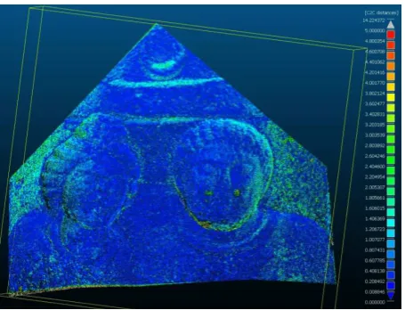
First of all, the point cloud provided by PhotoModeler Scanner of the reference headstone has been superimposed on the one provided by the ScanArm, by applying an ICP (Iterative Closest Point) algorithm (Besl, 1992). The same operation has been performed on the point cloud provided by PhotoSynth Toolkit. The discrepancies are quantified by computing the distance between one point cloud and the nearest neighbor found in the reference point cloud. The nearest neighbor solution is acceptable since the point clouds under study are regular and equally dense. The results of the comparison between both test clouds and the ScanArm cloud are presented in Figures 4 and 5.
Figure 4. Comparison between PhotoModeler Scanner point cloud and reference point cloud.
Figure 5. Comparison between PhotoSynth/Photo-Synth Toolkit point cloud and reference point cloud.
When comparing the clouds produced by PhotoSynth/PhotoSynth Toolkit and the ScanArm, an average deviation of 0.62 mm has been calculated. Several experimentations have been performed, which confirmed these very good results. The highest deviations are again located at the boundaries of the headstone (green/cyan areas in Fig. 5), but not at the same place as in Figure 4. Consequently, both solutions provide accurate results, but with slightly different point clouds (Table 6).
PhotoModeler PhotoSynth/Photo-Synth Toolkit Average deviation
from the reference cloud
[max. deviation]
0,69 ± 0,49 mm [11 mm]
0,62 ± 0,58 mm [14 mm]
Table 6: Accuracy calculation of point clouds obtained with PhotoModeler and PhotoSynth solutions
As a summary, it can be noted that for both software used for generating the point cloud, an accuracy of about 0.7 mm has been reached. These results are satisfactory, because they prove that the millimeter accuracy required by the archeologists is respected.
Table 6 shows also that in our case, Photosynth / Photosynth Toolkit provides the same accuracy as PhotoModeler Scanner. As reported in Table 2, the Photosynth / Photosynth Toolkit solution brings also many benefits to the user, like a low processing time. However, it keeps a black box for the processes and does not provide quality criteria allowing to validate the results in a scientific approach.
At this stage, the point cloud is generated and can be followed by the model scaling, segmentation, resampling, meshing, texturing and at last its delivery. All these steps compose the whole processing chain leading to a coherent and reliable 3D photo-realistic model for the archaeologists. It has then been applied to all figured headstones.
5 . FROM POINT CLOUD TO TEXTURED 3D MODEL
Test patterns have been distributed around the headstones in order to enable the scaling of the point cloud. For reducing the required storage space and the point’s redundancy, it is advised to perform a sub-sampling. In our case, a spatial sub-sampling allowing to keep one point every 0.5 mm has been chosen.
5.1 Mesh creation
Concerning the mesh process, several tools have been considered.
The free software Meshlab (ISTI-CNR) is a mesh processing software that has been developed for pipelines modeling (Pomaska, 2009). It contains a lot of tools enabling the edition, cleaning, inspection, registration of large meshes, etc. Applied on our point clouds, the results were not satisfying, probably because of the noise level of the data or of the non-homogeneous density occurring on some parts of the headstones. This solution has been abandoned.
After this, two software have been compared: Geomagic Studio (Geomagic GmbH) and 3DReshaper (Technodigit). 3D Reshaper proposes a mesh process in two steps, during which a number of parameters can be modified. Several tests must be planed in order to define the most adapted parameter values. In Geomagic, the mesh creation is more automated, but less adaptable. However the resulting mesh is editable and can be modified manually afterwards. From an aesthetic point of view, the mesh created by Geomagic seems to keep more details (Figure 7).
Figure 7. Mesh obtained with Geomagic (left) and 3DReshaper (right)
From a geometric point of view, the mesh models have been superimposed and compared regarding the deviations between them (Figure 8).
Figure 8 shows that 87% of the deviations are in the interval [-0.5 mm; 0.5 mm], i.e. in the required tolerance. As expected, the largest deviations are located at the boundary of the mesh model.
In order to analyse the mesh product, it has been compared to the initial point cloud. 96% of the deviations are located in the interval [-1 mm; 1 mm] and 68% are in the interval [-0.5 mm; 0.5 mm]. Therefore, the 1 mm accuracy is still respected.
5.2 Texturing
Texturing is the last step of the process leading to the 3D model. Here, texturing means the creation of a photorealistic model. This operation can be performed in the same software as those tested for the meshing step.
3DReshaper provides several solutions for texturing a mesh model: (a) application of photographs using homologous points in the image and in the mesh model, or (b) use of the orientation parameters of every camera, as produced by PhotoModeler. The last solution has been discarded, because the orientation parameters provided by PhotoSynth are expressed in relation to a non-specified reference. The solution (a) has been tested, but was not satisfying. In fact, it is difficult to find homologous points for every photograph covering a little part of the headstone. Even if points of interest can be found in the image, its homologous one in the point cloud does not necessary exist. Moreover, the obtained mosaic presents radiometric differences due to slightly different exposition conditions from one image to another.
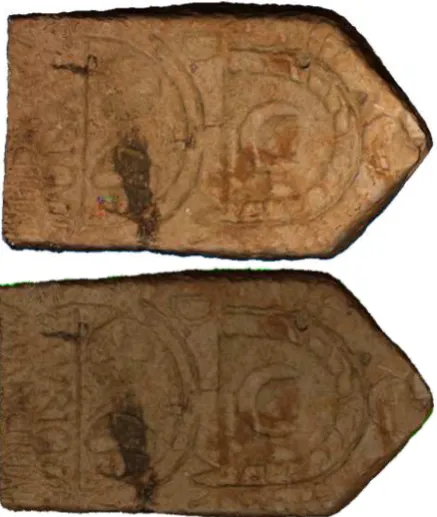
Geomagic proposes a way to texture, which is based on the RGB information of the point cloud. This allows bypassing the problem of junctions produced by images matching, as well as the inaccuracies implied by the research of homologous points. Figure 9 presents the results obtained with both software.
Figure 9. Textured model of a headstone obtained with the texturing tool of 3DReshaper (above) and Geomagic (below).
Due to the small size of the headstone taken as example (50 cm x 1 m), one image covered the whole headstone. It was not necessary to create a mosaic of images. Therefore, the 3DReshaper model does not present radiometric problems. However, the geometric quality of the matched image is not satisfactory. Some deviations reduce the readability of the inscription on the lower part of the stele. In the textured model produced with Geomagic, the inscription is emphasized and appears clearly, even if from a radiometric point of view, the texture could be brighter.
5.3 Delivery of the 3D models
It makes no sense to produce high quality 3D models for archaeologists, if their use is limited to visualization. For this reason, we decided to generate a 3D PDF file for every headstone. 3D PDF File format is readable by all types of plateforms using Adobe Acrobat Reader and enables to navigate easily in a 3D model. It is not only easy to read but provides also many tools for zooming, rotating, measuring, cutting planes creations, etc (Figure 10). For instance, the Simlab Composer software (Simulation Lab Software) enables the automatic creation of PDF3D files from a model stored as .obj file.
Figure 10. Textured 3D model of a headstone (PDF3D format) in Adobe Acrobat environment
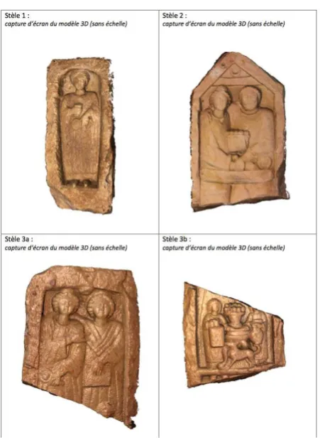
Using the whole processing chain explained in this paper, 13 headstones of different sizes and details have been acquired, modeled, textured and delivered to the archaeologists (see examples in Figure 11). At the moment, the resulting 3D models are under study by the archaeologists.
6 . CONCLUSION
Figure 11. Summary of 4 out of 13 headstones modeled in 3D
7 . REFERENCES
Alby, E., Grussenmeyer,P., 2012. From point cloud to 3D model, modelling methods based on architectural knowledge applied to fortress of Châtel-sur-Moselle (France), ISPRS Archives, Volume XXXIX-B5, pp.75-80.
Besl, P. J., 1992. A Method for Registration of 3-D Shapes, IEEE Trans. on Pattern Analysis and Machine Intelligence, Los Alamitos, CA, USA, IEEE Computer Society, vol. 14, no 2, 1992, p. 239–256
Falkingham, P.L., 2012. Acquisition of high resolution three-dimensional models using free, open-source, photogrammetric software, Palaeontologia Electronica, Vol. 15- Issue 1.
Kersten, T.P., Lindstaedt, M., 2012. Potential of Automatic3D Object Reconstruction from Multiple Images for applications in Architecture, Cultural Heritage and Archaeology, International Journal of Heritage in the Digital Era, Vol. 1, Number 3, pp.400-420.
Pomaska, G., 2009. Utilization of Photosynth Point Clouds for 3D Object Reconstruction, 22nd CIPA Symposium, October 11-15, 2009, Kyoto, Japan.