AUTOMATIC EXTRACTION AND TOPOLOGY RECONSTRUCTION OF URBAN
VIADUCTS FROM LIDAR DATA
Yan Wang a*, Xiangyun Hu a a
School of Remote Sensing and Information Engineering, Wuhan University, Luoyu Road 129, Wuhan 430079, China - (wang_yan, huxy)@whu.edu.cn
Commission Ⅲ, WG Ⅲ/4
KEY WORDS: Airborne LiDAR, Point Cloud, Overpass, Urban Viaducts Recognition, Topology Reconstruction
ABSTRACT:
Urban viaducts are important infrastructures for the transportation system of a city. In this paper, an original method is proposed to automatically extract urban viaducts and reconstruct topology of the viaduct network just with airborne LiDAR point cloud data. It will greatly simplify the effort-taking procedure of viaducts extraction and reconstruction. In our method, the point cloud first is filtered to divide all the points into ground points and none-ground points. Region growth algorithm is adopted to find the viaduct points from the none-ground points by the features generated from its general prescriptive designation rules. Then, the viaduct points are projected into 2D images to extract the centerline of every viaduct and generate cubic functions to represent passages of viaducts by least square fitting, with which the topology of the viaduct network can be rebuilt by combining the height information. Finally, a topological graph of the viaducts network is produced. The full-automatic method can potentially benefit the application of urban navigation and city model reconstruction.
* Yan Wang is with School of Remote Sensing and Information Engineering, Wuhan University. Email: [email protected]; Phone: +8615827193089;
1. INSTRUCTIONS
1.1 Background
Urban viaducts are usually transportation junctions of a city and play a key role in the whole transportation system. We have developed an original method that can automatically extract urban viaducts and reconstruct topology of the network just with airborne LiDAR point cloud data. To the best of our knowledge, there are few studies in this field. Our method provides a complete solution to recognize and extract urban viaducts full-automatically. It can be of great help in city model reconstruction, city road network extraction, navigation and so on.
In fact, viaducts are roads. A few researches have been conducted to extract road from LiDAR point cloud data and have achieved quite an accomplishment in recent years (Mena, 2013).
Combining the multi-spectral remote sensing images and point cloud data to extract road network is a popular study field (Akel and et al., 2005. Hu and Tao, 2007. Rottensteiner and Clode, 2008. Samadzadegan and et al. 2009. Hu and et al., 2004. Shao and et al. 2011, ). The remote sensing images contains distinguishable multi-spectral information, in the meanwhile, point cloud data has advantages of containing information of geometry and height, which can hardly be effected by occlusion and luminance variation. It turns out to be effective to take the advantages from different data sources. To detect road just by the point cloud data, which relies on a single kind of sensors and can avoid the complexity of merging different data sources, is also proved acceptable and has achieved significant improvement(Choi and et al., 2008. Hu and et al., 2014. Clode
and et al., 2004. Boyko and Funkhouser, 2011). However, the main subject of the studies for road extraction focuses on the roads lying on the ground and let alone the complex viaducts network. The problem of automatically extracting the complex viaducts network remains unsolved.
Building a model of viaducts needs not only a vivid appearance, but also detailed topology information for many applications. Point clouds of mobile laser scanning can generate viaducts model semi-automatically (Yang and et al., 2013). It builds the model with details, but it is time-consuming and has difficulties in covering large area quickly.
There are lots of algorithms developed to reconstruct the complex viaducts or overpass by combining road maps in 2D and 3D airborne point cloud (Harvey and McKeown, 2008. Chen and Lo, 2009. Wu and et al. 2014. González-Jorge and et al., 2013. Schpok, 2011.). It avoids the troubles to reconstruct topology. As the 2D road maps are manually acquired or generated from other data resources, these methods are also labour-consuming work and have its limitation in many applications.
With the increasing amounts of vehicles and the urge to avoid traffic jam, more and more viaducts are constructed. Our algorithm aims at extracting the complex viaducts network and reconstructing its topology quickly and full-automatically from the airborne LiDAR point cloud of an area.
1.2 An Introduction to Our Algorithm
Our study contains two main parts: urban viaducts recognition and topology reconstruction.
The objective of urban viaducts recognition is to find the viaducts points in the point cloud. It takes 3 steps to distinguish whether a point belongs to a viaduct or not.
1) Filter the point cloud to divide all the points into ground points and none-ground points (Axelsson, 2000). The viaducts points will be in the none-ground points.
2) Find the points that locate in the boundaries between ground points and none-ground points and treat them as the seed points.
3) Viaducts are artificial structures that are built according to some specific general prescriptive designation rules. A series of features are concluded from these rules as a region growth strategy. Conduct a region growing algorithm (Garcia and et al. 2009) from the seed points according to the region growth strategy, and then all the points that belong to the viaducts can be detected.
As most of the viaducts are complex networks where a passage may has multiple forks and viaducts can be overlapped by each other. By finding the viaduct points is not enough to tell how many viaducts are there and whether they are connected or not. Our algorithm tries to reconstruct the topology of the complex viaducts networks and give answers to the questions. Below is how we rebuild the topology of the complex viaducts networks.
1) The viaduct points are projected into 2D images.
2) To remove the noise in the images, flood fill algorithm (Ho and Marshall, 1990) and morphology operations are adopted.
3) The centrelines of the viaducts are extracted and every passage of a viaduct is represented by a corresponding cubic function by least square fitting.
4) With the best fitted functions, combining the height information, we can rebuild topology relationship of the viaduct network.
2. URBAN VIADUCTS RECOGNITION
2.1 Study Region
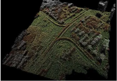
We take Zhuodaoquan viaduct in Wuhan China as our test subject. Zhuodaoquan viaduct is one of busiest transportation junction in Wuhan and plays a key role in relieving the traffic pressure of this city.
As shown in Figure 1 and 2, there are roads, multiple layers of passes, overlapped viaducts, trees, tall and low buildings, park, lake and so on within this region. The point cloud data contains 4.3 million points with the density of 15 points/m2. What we will do next is extracting the viaducts points from the whole point cloud.
Figure 1. Overview of the Zhuodaoquan Viaduct
Figure 2. Point cloud of Zhuodaoquan Viaduct
2.2 Viaducts Extraction Algorithm
Viaducts are artificial structures that are built according to the specific general prescriptive designation rules. A series of features are concluded from these rules as a region growth strategy.
1) It’s obvious that all the viaducts are above the ground and connected to the ground.
2) The curves of viaducts are generally smooth and continuous, some of which are merged, intercepted or overlapped.
3) Surfaces of the viaducts are smooth.
4) The slop of overpasses/bridges <=9%, according to ‘code for design of urban road engineering’ from China.
5) The width of a passage is 3.75 m according to ‘General code for design of high way bridges and culverts’ from China.
With a strategy composed of the above features, an iterative region growth algorithm from the seed points to the none-ground is conducted. The detail flow chart of the algorithm is shown in Figure 3.
LiDAR Point Cloud Data
Filtering by Progressive TIN Densification
Ground Points
None-ground Points Is the Point in the Boundary
between Ground Points and None-ground Points
Seed Points Yes
Find None-ground Points around a Seed Point and Delete the Seed Point
Do none-ground Points conform to Viaducts Features ?
No Is the seed Points
empty?
No Stop Yes
Label it as a Viaduct Point Yes
Figure 3. Algorithm Flow Chart of Extracting Viaducts Points
2.2.1 Filtering: The point cloud is filtered by progressive TIN densification (Axelsson, 2000) to divide all the points into ground points and none-ground points as in Figure 4. Purple points are ground points and yellow points are none-ground points. The viaducts points are in the none-ground points.
Figure 4. Filtered Point Cloud.
2.2.2 Seed Points Selection and Region Growth: The problems of a region growth algorithm focus on two aspects, 1how to select the seed points and what’s the region growth strategy.
Selecting the original seed points is simply taking the points lying in the boundary between ground points and none-ground points.
The region growth strategy is composed of the features derived from the specific designation rules as shown in Table 1.
Criterion Threshold
Is the point a none-ground point? *
Is the height difference between the
point and seed point
T
height?0.03
height
T
m
Is the slop difference between the
point and seed point
T
slop?T
slop
3%
Is the slop of the surface fitted by the
points
T
Sslop?T
Sslop
9%
Is the intensity of the point
T
i_ minand
T
i_ max?_ min
0
iT
,_ max
60
iT
Table 1. Margin settings for A4 size paper
The
height
T
may be different with different point densities. If a point conform all of the features, as said in Figure 3, we take this points as a new seed points and label is as a viaduct point. The result is shown in Figure 5.Figure 5. Viaducts Extraction Result by Seed Growing
The purple passage and green passage in Figure 5 should be connected. Because of occlusion, they break. What we will do next is bridging the gap caused by overlap and reconstructing their topology.
3. TOPOLOGY RECONSTRUCTION
We can extract the viaduct points from the point cloud now. But how many viaducts are there? Which two viaducts are connected? How many forks do the viaducts have? Which viaduct is higher? Only with correct topological structure information can we answer these questions. In this chapter, our method of reconstructing topology is introduced in detail. The International Archives of the Photogrammetry, Remote Sensing and Spatial Information Sciences, Volume XL-3/W3, 2015
It’s a challenging task to rebuild a topology because of the difficulties in representing and operating a 3D curve. So the viaduct points are reversibly projected into 2D binary images like in Figure 6. The viaducts topology is analysed in 2D images and obtain 2D connectivity. And then the viaducts are projected back to 3D space in order to use the height information for generating 3D connectivity. Topological graphs of the viaducts network are finally produced.
Figure 6. Viaducts in 2D Images
A whole process of reconstructing topology is shown in Figure 7.
Figure 7. Reconstruction Flow
3.1 Remove the Noise
Because of all kinds object on the viaducts, such as cars, trees, lighting facility and so on, it leads to two kinds noise in the images when projecting the 3D points to binary images. The holes caused by the objects on the viaducts and gaps caused by occlusion.
Firstly, flood fill algorithm (Ho and Marshall, 1990) is adopted to fill all the holes in the images. Secondly, morphology operations are conducted to bridge the gaps in the images. The two de-noise steps results in inputs in good condition for the further extraction of the centrelines.
3.2 Centrelines Extraction and Least Square Fitting
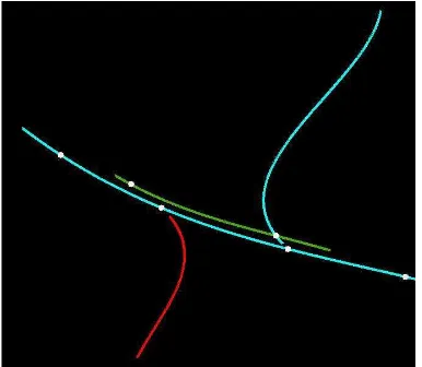
Extract the centrelines of all the viaducts by Zhang-Suen algorithm(Zhang and Suen, 1984) and fit every passage with a cubic function by least square fitting, There are several reasons why to represent every passage of a viaduct with a corresponding cubic function. First of all, it is appropriate for math analysis. All the interception points can be found by solving two curve equations which is simple and reliable.
Secondly, because of the annoying noises, the results of Zhang-Suen algorithm don't show in good appearances, expressing every passage of a viaduct with a beautiful polynomials function, where cubic function is enough according to our experiments, will lead to a good visual perception (see Figure 8).
Figure 8. Cubic Function Expressions of the passages
Figure 9. All the Potential Intersection Points
3.3 Topology Reconstruction
By solving the equations, intersection points can be calculated. Inversely project the intersection points into 3D space and get the height information of every intersection points, whether two passages are intersected in 3D space or not is obvious according to the height difference. As in Figure 10, topology relationship of the viaducts are reconstructed.
Figure 10. Topology Reconstruction Result
4. CONCLUDSION
In this paper, we have introduced a method that can automatically extract urban viaducts and reconstruct topology of the viaduct network with airborne LiDAR point cloud data. A topological graph of the viaducts network is finally produced. It is useful in urban navigation and city model reconstruction. The International Archives of the Photogrammetry, Remote Sensing and Spatial Information Sciences, Volume XL-3/W3, 2015
The future work will focus on improving the algorithm and constructing 3D digital viaducts models full-automatically.
ACKNOWLEDGEMENTS
Thanks school of remote sensing and information engineering of wuhan university for providing the airborne LiDAR point cloud data for our experiment.
REFERENCES
Mena J, B., 2003. State of the art on automatic road extraction for GIS update: a novel classification. Journal Pattern Recognition Letters Archive, 24(16), pp. 3037–3058.
Akel A. N., Kremeike K., Filin S., Sester, M., Doytsher, Y., 2005. Dense DTM generalization aided by roads extracted from LiDAR data. The international Archives of the Photogrammetry, Remote Sensing and Spatial Information Sciences, Volume XXXVI-3/W19, pp. 54-59.
Hu X, Tao V., 2007 Automatic extraction of main road centerlines from high resolution satellite imagery using hierarchical grouping. Photogrammetric Engineering and Remote Sensing, 73(9), pp. 1049-1056.
Rottensteiner F, Clode S., 2008. Building and road extraction by LiDAR and imagery. Topographic Laser Ranging and Scanning: Principles and Processing, Edited by Jie Shan, Charles K. Toth, CRC Press Tayloar & Francis Group, pp. 445-478.
Samadzadegan F, Hahn M, Bigdeli B., 2009. Automatic road extraction from LIDAR data based on classifier fusion. Joint Urban Remote Sensing Event, Shanghai, China, pp. 1-6.
Hu X, Tao C V, Hu Y., 2004. Automatic road extraction from dense urban area by integrated processing of high resolution imagery and lidar data. International Archives of Photogrammetry, Remote Sensing and Spatial Information Sciences, Vol. XXXV-B3, pp. 35-40.
Shao Y, Guo B, Hu X, et al., 2011. Application of a fast linear feature detector to road extraction from remotely sensed imagery. IEEE Journal of Selected Topics in Applied Earth Observations and Remote Sensing, 4(3), pp. 626-631.
Choi Y W, Jang Y W, Lee H J, et al., 2008. Three-dimensional LiDAR data classifying to extract road point in urban area. Geoscience and Remote Sensing Letters, IEEE, 5(4), pp.725-729.
Hu X, Li Y, Shan J, et al., 2014. Road Centerline Extraction in Complex Urban Scenes From LiDAR Data Based on Multiple Features. IEEE Transactions on Geoscience and Remote Sensing, 52(11), pp. 7448-7456.
Clode S, Kootsookos P J, Rottensteiner F., 2004. The automatic extraction of roads from LIDAR data. International Archives of Photogrammetry, Remote Sensing and Spatial Information Sciences, Vol. XXXV-B3, pp. 231-236.
Boyko A, Funkhouser T., 2011. Extracting roads from dense point clouds in large scale urban environment. ISPRS Journal of Photogrammetry and Remote Sensing, 66(6) pp. S2-S12.
Yang B, Fang L, Li J., 2013. Semi-automated extraction and delineation of 3D roads of street scene from mobile laser scanning point clouds. ISPRS Journal of Photogrammetry and Remote Sensing, 79, pp. 80-93.
Harvey W A, McKeown Jr D M., 2008. Automatic Compilation of 3D Road Features Using LIDAR and Multi-spectral Source Data. Portland, OR: ASPRS. Accessed January 1, 2014. http://www.terrasim.com/brochures/events/2008/2008ASPRS_P aper.pdf.
Chen L C, Lo C Y., 2009. 3D road modeling via the integration of large-scale topomaps and airborne LIDAR data. Journal of the Chinese Institute of Engineers, 32(6), pp. 811-823.
Wu Y, Cheng L, Wang Y, et al., 2014. Process of airborne lidar data for detection of complex overpass Geoinformatics (GeoInformatics), 2014 22nd International Conference on. IEEE, 2014, pp. 1-5.
González-Jorge H, Puente I, Riveiro B, et al., 2013. Automatic segmentation of road overpasses and detection of mortar efflorescence using mobile LiDAR data. Optics & Laser Technology, 54, pp. 353-361.
Schpok J., 2011. Geometric overpass extraction from vector road data and dsms. Proceedings of the 19th ACM SIGSPATIAL International Conference on Advances in Geographic Information Systems. ACM, 2011, pp. 3-8.
Axelsson P., 2000. DEM generation from laser scanner data using adaptive TIN models. International Archives of Photogrammetry and Remote Sensing, 33(B4/1; PART 4) pp. 111-118.
Garcia Ugarriza L., Saber E., Vantaram S. R., Amuso, V., Shaw M. and Bhaskar R., 2009. Automatic image segmentation by dynamic region growth and multiresolution merging. IEEE Transactions on Image Processing, 18(10), pp. 2275-2288.
Ho C M W, Marshall G R., 1990. Cavity search: an algorithm for the isolation and display of cavity-like binding regions. Journal of computer-aided molecular design, 4(4), pp. 337-354.
Zhang T Y, Suen C Y., 1984. A fast parallel algorithm for thinning digital patterns. Communications of the ACM, 27(3), pp. 236-239.