A HAND-FREE SOLUTION FOR THE INTERACTION IN AN IMMERSIVE VIRTUAL
ENVIRONMENT: THE CASE OF THE
AGORA
OF SEGESTA
Riccardo Olivito 1, *, Emanuele Taccola 2, Niccolò Albertini 1
1 Scuola Normale Superiore, Italy – (riccardo.olivito, niccolo.albertini)@sns.it 2 University of Pisa, Italy – [email protected]
Commission V, WG V/4
KEY WORDS: Interaction, Immersive Archaeology, Cyber-Archaeology, Virtual environments, CAVE, Image-based modeling.
ABSTRACT: The paper illustrates the project of an interdisciplinary team composed of archaeologists and researchers of the Scuola Normale Superiore and the University of Pisa. The synergy between these Centres has recently allowed for a more articulated 3D simulation of the agora of Segesta. Here, the archaeological excavations have brought to light the remains of a huge public building (stoa) of the Late-Hellenistic Period. Computer graphics and image-based modeling have been used to monitor, document and record the different phases of the excavation activity (layers, findings, wall structures) and to create a 3D model of the whole site.
In order to increase as much as possible the level of interaction, all the models can be managed by an application specially designed for an immersive virtual environment (CAVE-like system). By using hands tracking sensor (Leap) in a non-standard way, the application allows for a completely hand-free interaction with the simulation of the agora of Segesta and the different phases of the fieldwork activities. More specifically, the operator can use simple hand gestures to activate a natural interface, scroll and visualize the perfectly overlapped models of the archaeological layers, pop up the models of single meaningful objects discovered during the excavation, and obtain all the relative metadata (stored in a dedicated server) which are visualizable on external devices (e.g. tablets or monitors) without further wearable devices. All these functions are contextualized within the whole simulation of the agora, so that it is possible to verify old interpretations and enhance new ones in real-time, simulating within the CAVE the whole archaeological investigation, going over the different phases of the excavation in a more rapid way, getting information which could have been ignored during the fieldwork, and verifying, even ex-post, issues not correctly documented during the fieldwork.
The opportunity to physically interact with the 3D model of the agora increases drastically the level of affordance between operator and 3D simulation, and to verify with a completely new approach, issues which can be hardly investigated by using traditional 2D documentation.
1 INTRODUCTION
Since 2001 the archaeological investigations in the agora of Segesta, in northwestern Sicily, have brought to light a large part of the buildings which bordered the ancient public square (Ampolo, Parra 2012). In particular, the most interesting acquisitions of planimetric, architectural, and monumental nature are related to a large stoa with two projecting wings, which was built in the Late-Hellenistic period (end of the 2nd century BCE).
The accurate architectural study of the stoa (Abate, Cannistraci 2012) led to the formulation of a hypothetical reconstruction of the vertical development of the building.
Within this articulated monumental complex, during the very last years it has been possible to use new digital techniques of documentation, which have allowed for a significant improvement in the data acquisition phase, in the graphic documentation, and in the following elaboration processes.
2 WORKFLOW
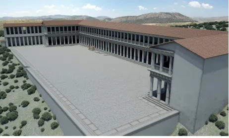
The 3D models of the agora were created with computer graphics (fig. 1) and aerial and terrestrial close range photogrammetry techniques, using software like AutoCAD, 3ds Max, Agisoft PhotoScan and Geomagic (Taccola 2012, Olivito, Taccola forthcoming).
Figure 1. 3D model of the agora of Segesta
The distinction between these two methods is obvious: in the first case, although we rely on measured data and consolidated studies of the elevations, we reconstruct the buildings as we presume they had to appear in a given historical period. In the second case, we use reality-based procedures in order to record objects and structures in their current condition.
In so doing, it is possible to enhance the quality of the scientific research on the Segestan public square, improving the level of interaction between user and digital models to be visualized within the virtual environment suitably created for the project.
2.1 A Virtual-Archaeological approach
preserving the high resolution textures without compromising the real-time visualization.
The model was implemented in a dedicated application for a CAVE-like System. Within this virtual environment, a "walk" interaction metaphor was developed to make the exploration as natural as possible. The interaction metaphor, limited to small movements, solved the conflict between a very large virtual environment (100 meters ca.) and the actual environment of the CAVE, that is much smaller (3 meters) (fig. 2).
Figure 2. 3D model of the agora within the CAVE
Overall, the interface ensures excellent functionality and immediacy of use.
Obviously, this 3D reconstruction, realized with computer graphics, has positive and negative features. As to the positive ones, the possibility to visualize and walk within the virtual environment allows us to think about issues that are hardly investigable by using traditional 2D tools. For instance: possible solutions adopted in the carpentry; physical and spatial relations between the stoa, its internal space, and the other monuments of the public square; relations between architecture, decorations, and documentary apparatus (e.g. statues and inscriptions); peculiar functions of the different sectors of the agora; the role played by natural and artificial lighting in different moments of the day.
On the other hand, this model was firstly conceived as a reconstruction more than a simulation (Clark 2010), with a limited level of interaction.
As a result, at present, it neither allows us to extrapolate or draw in real time information and data from the visualized elements, nor can be continuously modified.
2.2 A Cyber-Archaeological approach
With the most recent techniques used during the fieldwork activity and in the labs, a new approach was proposed, mainly oriented towards simulation and Cyber-Archaeology, as suggested by the recent literature (Forte 2010, Forte 2012). In this sense, the 3D model of the agora could represent a basis for further studies or, quoting Jeffrey Clark, a Simulation Slice. The starting point of this new research methodology is constituted by the introduction of techniques of close range photogrammetry, both aerial and terrestrial, used for the real-time documentation of the fieldwork activities and the digital drawings of the elements discovered during the excavation (Dell’Unto 2014).
As to the aerial photogrammetry, in the case of the agora of Segesta a MikroKopter Hexacopter UAV was employed, for whom an automatic flight plan was set up (fig. 3). The survey of the whole area of the stoa has required 3 flights, with a total of 664 shoots.
Figure 3. Flight plan for the aerial photogrammetry
The images acquired were turned into a 3D model of the entire agora, which constitutes the necessary basis for the positioning and alignment of all the surveys created with SfM terrestrial procedures. In fact, an appropriate number of GCPs was positioned and measured with total station to obtain the coordinates relative to the reference system used within the area of excavation.
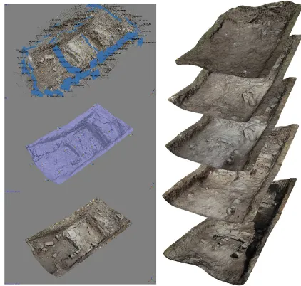
During the last campaign of excavation on the site of Segesta, 6 image-based models were created (fig. 4), following the progressive development of field activities. The excavation levels include the most superficial layers, up to the traces of medieval re-occupation of the area and those relating to the collapse and abandonment of the Late-Hellenistic stoa.
Figure 4. Some of the image-based models realized during the fieldwork activities
Each 3D model consists of several stratigraphic layers. In this first phase of the fieldwork, the nature of the stratigraphic deposit, simplified and uniform, did not required a work of semantic segmentation within the single model. However a first segmentation process has been started and will be enhanced in the next campaigns.
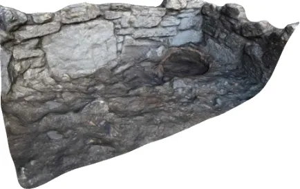
the excavation of the collapse layers of the stoa; and a medieval well-preserved oven of the Svevian period (fig. 5).
Figure 5. Image-based model of a medieval oven
The time required on the field to achieve a single model was about 20 minutes, including the acquisition of approximately 60 images for each level and the measuring of Ground control points with total station.
2.3 The application
Similarly to the 3D model of the agora realized with computer graphics, a virtual environment was created, in which the image-based models were loaded with Unity 3D Game Engine. Although still in progress, the application used to display and interact with models has already positive aspects, both from the scientific and technical point of view.
In the first phase the issues related to hardware were addressed, trying to figure out how to best use the tools of tracking. A support for glasses was modeled and printed in 3D, allowing for the use of an ultrasonic sensor and hand position sensor at the same time (fig. 6).
Figure 6. 3D glasses with the mounted leap-sensor
In fact, the use of the sensor applied on the user's head is not standard, since it has been designed to remain on a flat surface. Despite this, the device is used in a non-invasive way, thanks to the compactness and light weight of the Leap.
In particular, some of the new features of the 2.0 sdk leap sensor were employed as, for example, "automatic orientation", which allows for the automatic correction of the orientation of the hands, and "image acquisition", which allows for the use of the images that come directly from the infrared cameras in addition to the raw data tracking.
At this point we started the study phase of 3D interface and gesture linked to the exploration of the layers of the excavation.
The process of creating a gesture is structured as follows:
- Creation of base gestures (fig. 7): analysis on raw data input provided by the "leap sensor" and improvement through algorithms for data interpolation. Analysis of the data already processed and programming of "gesture base" (as the rotation of the hand, swipe, grab, etc.).
Figure 7. Snapshot of the creation of base gestures
- Creation of Complex gesture (fig. 8): by merging multiple "gesture bases" we created interactions in the environment, such as touch and rotation of objects, scroll and analysis between different archaeological data, etc.
Figure 8. Snapshot of the creation of complex gestures
- Evaluation: study of gesture designed to understand which would allow better interaction with the data at a theoretical level, according to usability principles redesigned for the 3D world (understanding of the interaction, ease of use, effectiveness, etc.).
Figure 9. Snapshot of the Implementation phase
- Study of user behaviour (fig 10): testing phase on different users with different skills to analyze the actual effectiveness of the gestures. Through a real-time feedback the gestures were corrected and revised according to the behaviour of the users.
Figure 10. Snapshot of the study of the user behaviour
- Review: revision of gestures based on user experience and new cycle evaluation, implementation and study of user behaviour.
Through this process it was possible to remove all the gestures too complicated for the device (for example pinch to zoom or rotate with the fingers) or too complicated for the user (gestures tiring or unnatural), thus implementing an interface the most natural and efficient as possible.
3 RESULTS
The purpose of the new application is to enhance the number and quality of functions that the operator can use and, as a consequence, the embodiment within the virtual environment. For this reason special attention is paid to the gestures available in the simulation.
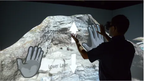
In particular, the application aims at improving the level of interaction between users and virtual environment, thanks to the possibility to visualize the perfectly overlapped and aligned digital models of the stratigraphic sequence realized during the fieldwork activity, to scroll between them within the virtual environment, and to query and interrogate the relative metadata only with hand-gestures (fig. 11)
The interface which has been realized is usable in a natural way, by hand movements. This makes the application friendly and easy to use.
At this stage, the control of gestures is limited to one user, whereas the visualization in the virtual environment is multi-user (3 or 4 people depending on the size of the CAVE). As to the leap, the detection of the position of the hand is very
accurate, due to a lightweight and non-invasive device. Obviously there are some features still to be developed, such as the possibility to increase the number of users that can interact through gestures. Nevertheless, these problems will be overcome with the introduction of wireless hand trackers that will make simpler to perform gestures in the virtual environment. At the same time, the introduction of the new tracker will increase the level of complexity of gestures, such as the rotation of the models or the measuring of distances, areas, volumes and so on.
Figure 11. The new application within the CAVE
A further element that has been tried to solve is the difficulty to visualize large amounts of text and metadata in the virtual environment (for instance records of the individual layers, records of architectural elements and artefacts found during the excavation). In fact, only the essential information, such as the layer number, the date of acquisition, or a brief description of the main objects visualized, are displayed within the CAVE. However, the problem of the analysis of large amounts of data was solved by creating links to the metadata that can be viewed through additional gestures. The links connect to the database directly with them, acquiring information on individual elements or modifying in real time the interpretations of the excavation data.
With regard to the models of the main objects found in the archaeological levels, both these elements were isolated within the single layers and perfectly overlapped into the stratigraphic sequence. Then, thanks to an interactive icon that appears only when the elements are visualizable, it is possible to pop up the models, rotate them, and zoom-in for a closer view of the objects.
century BCE. As a result, it is possible to shed new light on issues of great importance such as physical and spatial relations between objects and monumental context; internal and external visibility; relations between open and closed spaces; lighting inside the building.
We can now definitively affirm that this 3D model is enhancing a better scientific knowledge of the Segestan agora and a wider dissemination of the collected data to both the experts and the non-experts. At the same time, although in the development phase, the new application allows us to reach a higher level of interaction with the digital models, to interrogate them, visualize the metadata available for the single items, and, due to the hand-free nature of the application, to use external devices in order to examine records and texts while staying inside the CAVE. In so doing, it will be possible to virtually reproduce the field-work activity, working in an autonomous or collaborative way.
In the next months, the main goal will be the improvement of the quality and quantity of visualizable models and data. In addition to this, and aware of the limits of devices such as the Oculus Rift, the possibility to use this approach on this kind of device is evaluating, the final aim being a further reduction of the gap between the phases of data collection and elaboration, and that one of interpretation, even during the fieldwork.
AKNOWLEDGEMENTS
The excavation activities in the agora of Segesta are conducted by the Laboratorio di Scienze dell’Antichità (LSA) of the Scuola Normale Superiore (Director Prof. Carmine Ampolo) and the Department of Civilization and Forms of Knowledge of the University of Pisa (Prof. Maria Cecilia Parra).
The data acquisition is realized by the Laboratorio di Disegno e Restauro (LADIRE) of the University of Pisa, in cooperation with the Laboratorio di Scienze dell’Antichità.
The application has been developed in the Cave Automatic Virtual Environment of the DreamsLab of the Scuola Normale Superiore (Director Prof. Vincenzo Barone).
A demonstration video of the application is available at the following link: www.youtube.com/watch?v=vBJIpwSHQXA.
REFERENCES
Abate A., Cannistraci O., 2012. La stoa tardoellenistica dell’agora di Segesta: alcune note preliminari sull’elevato architettonico del lato Ovest. In C. Ampolo (ed.), Agora greca e Agorai di Sicilia, pp. 305-319.
Albertini N., Barone V., Brogni A., Legnaioli S., Licari D., Taccola E., 2014. The agora of Segesta in immersive virtual environments. In Science and Technology for the Safeguard of Cultural Heritage in the Mediterranean Basin, Proceedings of the sixth international conference, Athens, 22-25 October 2013, Vol. I, 2014, pp. 299-304.
Ampolo C., Parra M.C., 2012, L’agora di Segesta: uno sguardo d’assieme tra iscrizioni e monumenti, in C. Ampolo (ed.), Agora greca e Agorai di Sicilia, pp. 271-285.
Clark J.T., 2010. The Fallacy of Reconstruction. In Cyber-Archaeology, BAR International Series 2177, pp. 63-73.
Dell’Unto N. 2014. The Use of 3D Models for Intra-Site Investigation in Archaeology. In 3D Recording and Modelling in Archaeology and Cultural Heritage. Theory and best practices, BAR International Series 2598, pp. 151-158.
Forte M, 2010. Introduction to Cyber-Archaeology. In Cyber-Archaeology, BAR International Series 2177, pp. 9-13.
Forte M., 2014. Virtual Reality, Cyberarchaeology, Teleimmersive Archaeology. In 3D Recording and Modelling in Archaeology and Cultural Heritage. Theory and best practices, BAR International Series 2598, pp. 113-127.
Olivito R., Taccola, E., forthcoming. 3D modelling in the agora of Segesta: techniques and data interpretation. In Archeologia e Calcolatori 25, pp. 61-74.