INESI
ngs
of
rnrGrnail0nil symrusium
0n
Iarth
$cience
.i
:and
leohnologu
2013
lnamori [oundation
Memorial
Hall
l(yushu
Uniuersity,
Iulruofia,
lasan
0rganized
by
Gooperative International Network
for
Earth Science and Technology
(CINEST)
MAII'SUSHIMA CO.,LIfID.
Processing Institute of Japan (MM|J) Kyushu Branch
.of Goal Mining Technology
t*.:1.;6
@
by
CINEST
,::,."'.
..: 1 .t"- - . ,
ffi-1r
"r*
.t' ':'r-=@q
...,:::1:e.+:,:::;.'+!
""'=:Gontents
Paper
No.
Paper Title andAuthors
pagePrenary
Educating
Managers
and
Leaders
for
Sustainable and Socially
Responsible
l
I
Mining in
Africa
Jean-Paul
FRANZIDIS
Prenary
Energy Efficiency
Improvement Opportunities
in
the
Mineral
Industry
3II
Raj SINGHAL,
Kostas FYTAS01
Information and
System Management
in
the
Framework
of
the
Project:
8Innovation
of
Bc
and
Ms
Study
Programmes
at the
Faculty
of
Mining
and
Geology, VSB-Technical
University of
Ostrava
(INO
HGF)
Oldrich KODYM
02
Development
of
New
Type Expansion
Rock
Bolt
t4
Yun-Young Jeong, Sang-Ho Cho, Sang-Sun |eong
03
Visualization
of
Methane Flow
in
Area
with
Two Degassing
Boreholes
18Pavel
STASA,Oldrich
KODYI4 Miroslav
STOLBA04
Study
on
Estimation of Re-entry Time
after
Blasting in Underground
Mining
24PT
Cibaliung Sumberdaya, Indonesia
Sandro Flanaehan SIRAIT,
Nuhindro
PriagungWIDODO, Mikha SIMANIUNTAK
05
Support
Design
of
Cut
and
Fill Mine Method
at
Underground Gold
Mine
29PURWANTO,
Hideki
SHIMAD&
Takashi SASAOKAKikuo
MAISUI,
RidhoWATTIMENA
06
Discontinuity
Spacing
Correction
Factor
on
Predicting
Penetration
Rate
of
37Rotary-Percussive
Drill:
The Laboratory
Scale
Model
Ganda
M.
SIMANGUNSONG, Prathama I. FEBRIANTO, SusenoKRAMADIBRATA
07
Bearing Capacity
Correlation
by
Using
Dynamic
Cone Peneterometer
Test
43and
California
Bearing
Ratio
Test
for
Mining
Equipment
Recommendation
Barlian
DWINAGARA, Oktarian
WisnuLUSANTONO
0B
Geotechnical
Study
for
Optimizing
the Outpit
Dump
at
PT
Bhumi
Rantau
48Energi Open
Pit
Coal
Mine
Budi
Sulistianto,Kristijuliantika
Agustian,Tri
KarianGinting Jalu Kusuma, Cecep H. Setiadi
09
Assigning Economic
Values
on
Mining
blocks
and
Cut-off
Grade
54Determination
by Break-Even
Analysis:
A Case
Study
of
the
Marampa
Iron
Ore
Deposit.
Abu-Bakarr ]allotr,
Kyuro
Sasaki10
Recycling
of
Trash Mixture Tsunami Sludge
by
using Screening
and
59Improvement
Hiroshi
TAKAHASHf
ShinyaIZUML
SatoshiSHIBAT,!
MasatoMORI
11
Removal
of
Cesium, Cobalt,
Strontium,
or
Some
Other
Metals
Detected
64Around
Fukushima
from
the
Aqueous
Solution
Using Microbial
Cells
Takehiko TSURUTA" Kazluya
SAWAMUKA|
RyohtarohNAKAMURA
Shun OGASAWARA, Rie
NATSUBORI
DaishiUMENAI
-1-Paper
No.
paper Titte and Authors12
A
Preliminary
study
on
the
Simulation
of the
Effects
of
parameters
on
Hydraulic Fracturing
of
a
Horizontal Well
in a Shale-Oil
Reservoir
sujaree
woRAporpISAN,
Chatsuda KULTAVEEWUTI,supol ]IARASUPHAT
Svein Tore OPDAL, Kreangkrai
MANEEINTR
13
codeposition of
Silica
with
suspended
particles
in
porous
Media
Loren TUSARA,
Ryuichi
ITo!
YoshitakaKAWAHARA,
DaisukeFUKUDA, osamu
KAT9
14
EoR Development Screening
of
A
Heterogeneous Heavy_oir
Field
in
Southern of
Oman Using
Stejm
Flooding
71
83
Page
70
112
IbrahimAl
HADABI, Kyuro
SASAKI,yuichi
SUGAI15
Natural
state
Numerical
Model
of
Lahendong
Geothermal
Reservoir,
North
87
Sulawesi, Indonesia
AIiASHAT
Nurita
putri
HARDIANI, Ahmad
yANf
Ryuichi ITOI
16
Numerical
Simulation
of
Groundwater Flow
and Heat rransportation
in
93
Krang
Volcanic
Area,
Indonesia
Aiko
HARADA'
RyuichiITOf
Boy yoseph CSS SyahALAM
17
Recharge
source
and
Groundwater
Flow
system in
Mt.
Karang
west
Java,
Indonesia
Based
on
the
Stable Isotopes
Boy Yoseph
css
syAH ALAI\{, Ryuichi
IToI,
sachihiroTAGUCHI
18
Granitic
Magmatism
and
Related
ore
Deposit
in sulawesi,
Indonesia
Adi MAULANA,
Kotaro YONEZU,Koichiro WATANABE
Akira IMAI
19
Sr-Nd-Hf
Isotope
Geochemistry
of
Early
Yanshanian
Granitoids in
Central
Nanling Region,
south
china:
Impricafions
foi
wigmatic
Evorution
and
Tectonic
Environment
IHuan LI,
Koichiro
WATANABE, KotaroYONEZU
20
characterizations
of
LREE
or
Nd
Doped Aruminosirica Gers
by
Sor_Ger
Method
for
preparing
a
caribration
cuive with nigh
;..rru.v
JUNYA
KANEMITSU,
KOIATO YONEZU, KOiChirOWAriruANg,
TAKUShiYOKOYAMA
21
RFID Technorogy
in Industriar
Environments
with
Risk
of
Exprosion
pavel STAS,{
}iri
SVUB,ZbynekKOCUR,Iakub
UNUCKA
22
Utirization
of
RFID Technorogy in
Transportation
systems
of
opencast
Mine
Filip
BENEg pavel STASA, Jiri SVLIB,Vladimir
KEtsO
23
Reliability
of
Reading.in
Management
system
Based
on
AIDC
Technorogy
for
Special
Goods
and
process-es.
- '
---'
]uraj
VACLTLI6 peter KOLAROSZKL
Iifi
TENGLERIdentification
of
Metal Objects
and
RF
Transparent
Up
with
Liquids
Jiri SVUB,
Vladimir
KEBO, JakubUNUCKA,
LukasVOITECH
25
The
Use
of
RFID
Technology
in
Underground
coal
Mines
Environment
t43
Vlaclimir
HoN,
Milan
ODRIHOCK!
Miian
KRPEC, purr"letNoa,
Vlatlimir
KEBo
108
24
Radio
Frequency
Containers
Filled
120 123 129
IJ '
139
-u-Paper
No.
paper Tifle andAuthors
page26
The
Use
of
Physical Model
to
Predict Surface Subsidence
of
prototype
by
147using
Dimensional Analysis
Tri KARIAN,
SusenoKRAMADIBRATA,
Budi
SULISTIANTO27
Stability
Control
of
Roadway
in
Protected Seam
of
Deep
High-gas
154Multi-seams
through
Ascending Mining
in
China
Deyu
QIAN,
Takashi SASAOKA,Hideki
SHIMADAVKikuo
MAISUf
Cheng WANG28
Mechanism
of
Localized Stress Concentration
in
Interlayer
Rock Mass
and
161Its Impact
on
Deep
Multi-seam
Mining
Mingwei ZHANG,
Takashi SASAOKA'Hideki SHIMADA" Kikuo
MATSUI29
Geotechnical Issues
of Narynsukhait
open
pit
coal
Mine
169TsedendorjAMARSAIKHAN,
RyoyAMAMoro,
Akihiro HAMANAKA,
DeyueIAN
Iakashi
SASAOKA,Hideki
SHIMAD&
Kikuo
MATSUI30
Post
Closure
Water Quality Simulation
of
Mangkalapi
pit in
Batulicin
Coal
174Mine,
South Kalimantan,
Indonesia.
Sendy
DWIKI,
Rudy SayogaGAUIAMA,
Fatimah KOTENHideki SHIMADA,
Ginring JatuKUSUMA
31
Preliminary Assessment of Groundwater Contamination
Hazard in Open
pit
180Coal Mine, Barito
Timur, Central
Kalimantan, Indonesia
Shofa
Rijalul HAQ,
Doni prakasa Eka pUTRA, BarlianDWINAGARA
32
Study of
Silicate Coating
on
Pyrite Oxidation Suppression:
Fundamental
I89
Mechanism
and
Kinetic Analysis
Hajime
MIKI,Tsuyoshi
HIRAIIMA, Mutia Dewi
yuNIArI,
Keiko
sASAKI
33
Electrochemical
Study
of
Silicate
Coating
on Sulphide
Minerals
Oxidation
1g3Suppression
Mutia Dewi YUNIATI,
TsuyoshiHIRAIIMA,
HajimeMIKI,
Keiko SASAKI34
Atrnospheric
Leaching
Behavior
of
East
Java
Chalcopyrite Ore
in
Sulfuric
1g7Acid
Solution and
Hydrogen peroxide as Oxidizing Agent
M.Z. MUBAROK
A.DILOVA
35
Leaching
Behavior
of
Nickel
from
Indonesian Nickel Laterite Ores
by
2oz
Atmospheric
Acid Leaching Using Citric
Acid
Widi
ASTUTI, TsuyoshiHIRAIIMA,
KeikoSASAK!
Naoko OKIBE36
Purification
of
MgCl2
Solution Generated
By
Leaching
of
Ferronickel
2a6Smelting
Slag
for
preparation
of
MgO
powder
A. YUDIARTO, M.Z.
MUBAROK
37
Delineating Biodiversity Conservation Corridors
Using
Analytic
Hierarchy
211Process (AHP)
and GIS:
A Case
Study
in Thua
Thien
Hue
province, Central
Vietnam
Nguyen Tien
HOANG,
pham VanHtIyNH,
Katsuaki KOIKE38
Construction
of
a
GIS Comprehensive
Base
System
for the
Development,
217Circulation and Utilization of
Geospatial
Information
PoPPy
INDRAYANI,
YasuhiroMITANI, Ibrahim DJAMALLIDDIN
andHiro IKEMI
-111-0n [erut Scic[co and Isch[oloCy Zltto
Preliminary
Assessment of
Groundwater
Contamination
Hazard
in
Open
Pit
coal
Mine,
Barito
Timur, central
Kalimantan,
rndonesia
shofa Rijalur
HAe',
Doni prakasa EkapurRA2,
Barlian DWINAGARA3I
Postglaluate
programof Georogicar Engineeiing of
uGM,
yogtakarta2 Department of Geological
Enginiering
UbU, fog,,o*oio
3
Department of Mining Engineering of
UpN
,,veteran,,, yog,,akartacoal
mining industry is an important sectorn tn!!rsJ"Xt2!ono.,"
of Indonesia. Many mining companies are widespreadin
Indonesia, especiallyin
Kalimantaniland. It
is,"cognired
that environmental'impacts of openpit
mines are not only natural landscape changing, but also human hf,alth hazards. Themos;t sign'ificant of them
is
theprobability of
groundwater contaminaiion. Accordingto
erwironmental regulationsin
Indonesia, eachmining
camponyis
obliged
to
have
EnvironmentalImpact
Assessment(EIAI
document, beJbre startingproduction'
Thepurpose
of
this study
is
to
assess groundwater contaminationhazard
causedby
miningactivities,
as a
part of
EIA.
Groundwater contaminationhazard
is
evaluatedby
combinrngthe
intrinsicgroundwater
vulnerability and the
contaminantsloading
in
the
minearea.
DRAST1cmethoi is
applied toobtain
thegtoundwater vulnerability, while contaminait
loadingpotential
is
evaluated based
on
stepwiseprocedure hazard of contaminants,
application.
The resubsof
this study are groundwateiiontamination
hazard maps. Basedon
theit
can be concluded th'at the ilighestground.rte,
hazard areawill
be occurred at theNorth of
study
area'
Therefore,the
mitigationfor thi
dociment
of EIA
will
be
concernedthere.
Furtherresearch may need to complete this preliminary study.
Keywords: EIA, Loading Coniqminant, Groundwater Vulnerability, open
pit
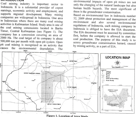
Coal Mine, DRASTIC.INTRODUCTION
Coal mining
industry
is
important sector
toIndonesia.
It
is a
substantialprovider
of
exporteamings, economic
activity
and employment, andsupports
regional
development.
Many
miningcompanies are widespread
in
Indonesia. One areain
Indonesian where there are manycoal
miningactivities is Kalimantan Island. Study area is one
of
the
coal mining
concessionslocated
in
BaritoTimur,
Central Kalimantan (see
Figure
l)-
Thecompany
has
a
concessioncovering
an
areaof
]000
Ha
The coal targetof
its
companl,is
about 500,000 ton per monthwith
openpit
system. Openpit
coal
mining is
recognizedas an activity
iharcauses
the
environmental degradation.
Theenvironmental impacts
of
openpit
mines are notonly the changing
ofthe
natural landscape but alsohuman
headth hazards.The most
significant
of
them is the groundwater contamination.
Based on environmental
law in
Indonesia number32, 2009 about protection and management
of
theenvironment
and
also
several
invironmentalregulations
of
Indonesia, eachmining
company inIndonesia
is
obligedto
havethe
EiA
document.The
EIA
document must be assessed by committeefirst,
beforethe
companyis
allowed
to
start thecoal
production.The
purposeof
this
study
is
toassess groundwater contamination hazard,, caused
by mining activity, as a part
of
EIA.LOCATION MAP
",$'
"-s\,
vuffi
, Oi*rrd Eoundn.y
Arei Study
Figure
l.
Location of Area Study-iBO-According
to
Putra (2007),
the
groundwatercontamination hazard
is
defined
asthe
probabilitythat
groundwater
in
the
aquifer
will
experience negative impactsflom
a given anthropogenic activityto
such
level that
its
groundwaterwould
becomeunacceptable
for
human
consumption.The
mostlogical
approach
to
assess
the
groundwatercontamination hazard based
on
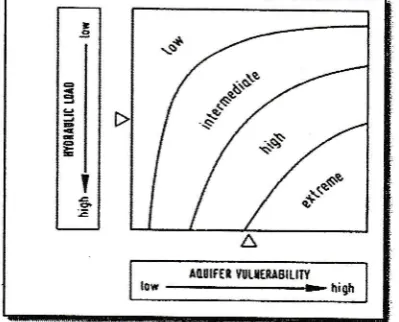
Foster
&
Hirata(1988), Foster et al, (2002), Morris et al. (2003) is to
regard
it
as
interaction
betweenthe
contaminantloading
(that is,
will
be,
or,
might be,
applied on subsurface environment as a result of human activity)and intrinsic groundwater vulnerability at the Iocation
concerned (See Figure 2).
probably
the
most
widely
applied,
scheme
of
lulnerability
assessment was developedin
USA
andis known as the DRASTIC methodology
(Aller
et al.,1987).
It
uses seven parametersin
its
calculationof
"Vulnerability
Index,,
with
each
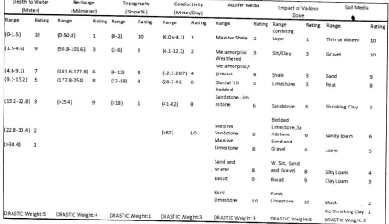
parameter being assigned a specific weight and rating values as shownin Table
l.
Thefollowing
seven parameters are depthto
groundwater,net
recharge,aquifer media,
soilmedia, topography,
impact
of
vadose zone.
andhydraulic
conductivity. Vulnerability
tocontamination
is a
dimensionlessindex function
of
hydrogeological factor, anthropogenic infl uences and
source
of
contaminationin
any given area (pllnnaleand Angle, 2002): The r,ulnerability index consists
of
seven parameters with difference weighting factors.
It
is calculated based on EquationI
below.7
V
=
L{Wix
RiJ
trl
Where
tr/is
the index
value,
W'iis
the
weightingcoefficient
for
parameteri
with
an associatediating
value
of
R,. TheDRASTIC
parameters are weightedfrom
1to
5 according totheir
relative importance incontributing
to
the
contamination potential.
Theoriginal DRASTIC
method publishedby
Aller
et al.(1987) does
not
provide vulnerability
classificationranges.
It
allows the user to interpret the vulnerabilityindex using
their own field
knowledge
andhydrogeological experience
(private
communicationwith
Putra, 2013)
Therefore,
in
this
study,
thevulnerability index
is
using the classification systemfrom
Civita
andDe
Regibus 1995,Corniello et
al. 1997.This
classification system definesfive
classesof vulnerability of DRASTIC:
.
Very high vulnerability (rulnerability
index>199),
.
High vulnerability (160-199),.
Moderate vulnerability (120-159),.
Low vulnerability (80-1l9),
and.
Very low vulnerability (<79).Contaminant Loading
PotentialFoster (1987) and Foster and Hirata (1988) developed
a rating method
for
a common evaluationof
variousanthropogenic
contamination
sources.The
ratingsystem
is
based
on the
evaluation
of
four
keycharacteristics
of
the
groundwater
contaminationsources (Johansson and HiratE 2002):
1.
Class
of
contaminants;t)?e
of
contaminants,mobility
and
persistence properties
of
acontaminant
in
respect
of its
potential
to contaminate groundwater.2.
Intensity
of
contaminants: concentrations andextend
of
contaminant,
which load
to
the subsurface.3.
Modeof
disposition; refer to the vertical locationof
contaminant sources
and
the
associatedhydraulic loading.
Figure 2. Groundwater
contamination hazard
asinteraction between groundwater
vulnerability
and
contaminant
load(Morris
et al., 2003)The
relationship between contaminant
loadingpotential
(caused
by
mining activities),
intrinsicgroundwater
vulnerability
and
probability
of
groundwater contamination
in
the
area study
isneeded
to
assessthe
environmental
impact
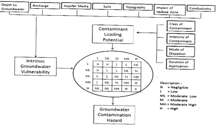
to groundwater as a part of document.METHODOLOGY OF ASSESMENT
Intrinsic
Groundwater
Vulnerability
According
to
Foster
et al.
(2002),
the
term"vulnerability"
began
to
be
used intuitively
inhydrogeology from the 1970s
in
France(Albinei
andMargat, 1970) and more
widely
in rhe I 980s (Haertle,1983;Aller
and other, 1978; Foster and Hirata, lggg).The concept is based on the assumption that the
soil-rock-groundwater system
may provide
a
degreeof
protection against contamination
of
groundwater by"self
purihcation" or "natural
attenuation,, (Romijn,2AA4.
The
overall
aim
of
the
vulnerabilityassessment process is to provide relevant information
for
land-useplanning
decisions, sothat
potentiallypolluting developments can be located and controlled
in
an
environmentally
acceptableway (Daly
andWarren, 1998).
Groundwater
vulnerability
is
usually
estimated indifference methods.
In
most case, these methods areanalytical
tools
that
try to
relate
groundwatercontamination
to
land
useactivities
(Javadi,20ll).
Depend
on
Foster
(1998),
the
best known,
andil
tffi
l';r-nrgnl
-Table
l.
DRASTIC
W
andRati
tem i: t j !' !4.
Duration
of
application; probability
thatcontaminant
will
be
discharged and period orintervals for which contaminant load
ij
applied.In.the
view
of
complexity
of
factors
aiGctingpollutant migration
and uniqueness of. eachfield
situation,
it
would be logicalto
treat each activityor
source
of
individual
merit and
undertakeindependent
field
investigations
to
assesscontaminant
loading potential (Foster
&.
Hirata,1988). However, such investigation
will
be
of
ahigh cost and therefore simpler but consistent low
cost procedures are needed.
A
further complicatingfactor
is
that
contaminantloading
potrniiul
*ill
itself
changewith time,
ashumanlitivities
at theground
surface change(putra, 2007). There
areglty
few
comprehensivemethods
specificallydirected
to
quantiry
the
contaminant
loadingpotential. Modified
method version according tol:huT.ron
&
Hirata (2002) is applied in this st"udy(See Figure 3).
A
relativeratingof
the contaminantloading potential
of
a
sourceis
differentiated infive-
classes:
high,
moderate
high,
moderate, moderate low, and low. Thefinal
rating is obtainedby applying stepwise procedure
ofthree
evaluationsteps,
the
stepwise procedure promotes
betterunderstanding
of
the
evaluation
process
andevaluates
the
result
of
the
combination of
parameter at time . (Johansson andHirata,2002).
The
first
step
is
determinationof
contaminanttransport characteristic.
At
the first
diagram, thecontaminant
class
is
evaluated based
on
themobility
and persistence of each contaminant in thesubsurface.
At
the
second diagram,the
modeof
disposition
of
the
contaminant
is
evaluatedaccording to relation between depth of contaminant
discharge
to
the
groundwater surface
and
thehydraulic load
of
source. Contaminant transport isa matrix combination
of
the contaminant class andthe mode of disposition.
The second step is determination
of
contamination source strength.The relative
contaminantload
isevaluated based on the proportion
oflocal
rechargeaffected and the contaminant concentration, which
relative
to
WHO
guidelinesvalue.
On
the
otherhand, the duration
of
contaminant load diagram is evaluatedby
theprobability
and the durationof
acontaminant load. Each contaminant concentration
load is
predictedby
analogical datafiom
effluentgroundwater in existing coal mine area.
The last
step
is a
matrix
evaluation
of
thecontaminant
transport obtained
first
step
andcontamination
source
strength obtained
in
the second step. Thefinal
result
of
these stepsis
thefinal
classification
of
the
potential
groundwaler contamination load of the contamination source.Groundwater Contamination
HazardAfter the
groundwater
wlnerability
and
thecontaminant loading potential in mining concession
plan
are assesSed, then continuedbyletermining
the groundwater contamination hazaid. According
to
Putra (2007),
the
combination
betweengroundwater vulnerability (natural factor of hazard)
and contaminant loading
potential
(anthropogenicfactor
of
hazard)
are
proved scientifically
assignificant parameters- on estimating the probaLility
of
contamination hazard. Therefore,
matrixevaluation
(private
communication
with
putra,2013)
for
groundwater contamination
hazard, assessmentis
applied
in
this
study.
Conceptual stagesto
assess groundwater contamination hazard,in this study are presented in Figure 4.
-182-Depth to Water
(Meter)
Re c ha rge
(Milimeter)
Topog rap lry
(slope % )
Corductivity Aquifer Media lmpact ofvadose Soil Media
Zo ne
1.s) 10
1.
'4.6) 9
Rating Range Rating Range RatirE Range Ratir€ *"n,
Cmfinir€
{0-50.8) 1 (o-2) 10 {0.044.1) 1 Masive Shale 2 Layer 1 Thin d Absent 10
(50.&101.6) 3 (2-6) g l4.t-12.3| 2 Metamorphjc 3
Siltrclay 3 cravel 10 W ea tfu red
Metamorph ic/l
(101.6-177.8) 6 (5,12) 5 112.+28.71 4 Sneous 4 Shate 3 Sand g 1L77.8-254]1 8 i12-18) 3 (28.7-41) 6 GtaciatTlil 5 Limestore 3 peat 8
Bedded
Sandstore,Lim
{>254) 9 (>18) 1 i41€2) 8 estore 6 sand$ore 6 shrinking ciay 7 8ed ded
Ma$ive Limestore,Sa
(>82 ) 10 $nd*ore 6 ndsttre 6 sandy Loa m 6
Ma$ive Sand and
Limestore g Gravel 6 L@m 5
Sand and W. Silt, Sand
Gravel 8 and Gravel 8 Sitty Loah 4
Basalt 9 Basalt 9 Clay Loam 3 Ka rst Kars,
Limestore 10 Limestore 10 Muck 1
NoShrinking Clay 1 DRAST lC Weig ht:4 DRAST lC Weig ht:1 DRAST tC Weig ht:3 DR AST tc WeiB fr:3 DR ASI rC weig ht:5 ?p.4sr ta :..r.tE l-i- 2
.G9.1) 7
.1-1s.2) s -22.8J 3
22.8-30.4) 2
=
l:
=ti- l! E IF!,
t--,L
I;
H 1l
IJ
M
M
-i
M M L
M H MH L ML
u
L
M M MH H H M M MH H H
L ML M MH H
L L ML M M
L L l\,tL M M M
ML
t-l u
I
u
lrrar-l
r.a|
rurI
i:rtffe*ryrm
M MH H ,{
Maerare'----S*$95*'*"6t'
Figure
3'
Stepwise proc€ss ofobtaining
thefinal rating
of contaminant loadingpotential
(Johansson andHirata,2002, modified
byputra,
20071Oes<.iption :
N = N.tlitlbl.
ML = Moderate Low
M - Mod.6tc
MH . ModcEte Hith
H - Hlth
(modified
from
Putra,
2007)Figure 4.
conceptuar
stages to assessgroundwater
contamination hazardRESULT
AND DISCUSSION
Intrinsic Groundwater Vulnerability
of
CoalMine
Area in Barito
Timur
The attribute layers
for
DRASTIC
parameters areassembled
within
a
Geographic
InformationSystem
(GIS) format.
Depthsto
groundwater areabout 9.4 to 33.3 meter, measured from exploration
and
geotechnical boreholes.
Using
the measurements at these points, thetwo
dimensionalvariation
of
depths to groundwater are constructed.Recharge
is
calculatedflom rainfall in
coal minearea.
Rainfall
in
study
areais
included
in
highcategory.
It
is
approximately
3000 mm.
Highrainfall
may influence significantlyto
groundwatercontamination.
High rainfall
makes
contaminantable
to
reachthe
groundwatereasily.
Based ondrilling
logsfor
each borehole,soil
tlpes
in
areastudy
are
categorizedby
sandy loarn and
peat,while aquifer media and vadose zone are classified
by
massive
sandstone
and clay.
Hydraulicconductivity distribution
in
areastudy
is
0.0gg_ 1.334 m/day.It
is
developed usingslug test
and-183-MH H
ML
L ML
Contaminant Loading Potential
L r rt. \IL
rot lt
L
L
L t[ Nt \l]I t!
Groundwater Contamination
GIII$I18.3I tTilIPEDGil
pumping test at geotechnical boreholes. Using the
topographic
map
of
the
study
area prepared byUSGS, a
digital
elevation model(DEM)
is created.According to slope map obtained from DEM model,
the slopes values are varied between 8-15 %.
After
determining
all
the
necessary maps, eachmap
isclassified
and
rated,
then
multiplied
by
itsweighting factor to calculate DRASTIC index.
The index result was
divided into
5
equal groups(Aller et
al.,
1987). Large numbers indicate highrulnerability
potential and small numbers indicatelow
vulnerability, based
on
the
classificationsystem
fiom
Civita and
De
Regibus
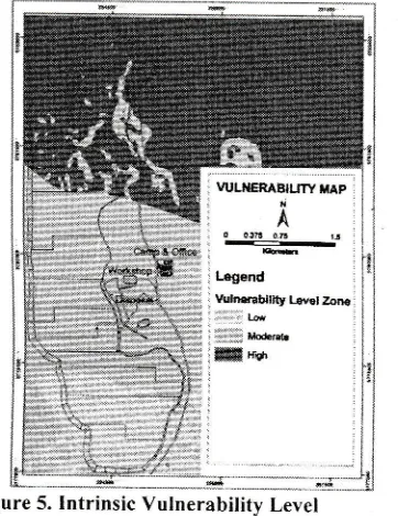
1995,Corniello et al. 1997 (see Figure 5).
Figure 5.
Intrinsic
Vulnerability
LevelLoading
Contamination
Hazard
of
Coal
Mine
Area in Barito
Timur
Natural
groundwaterquality
in
Barito Timur
ismalyzed,
to
know
the
probability
of
existingloading contaminant
in
study area (Table 2). Based on guideline value for drinking water (WHO, 2004), natural groundwaterin
BaritoTimur
is acceptable.None
of
water component concentrationis
higherthan the guideline value.
Mining
operation does notonly
need the heavy equipment,but
alsoa
lot
of
employee as operators, officers, mechanics, helpers,
chefs,
and
othersThe effect
of
this
condition
iscommonly
adverseon the
quality
of
recharge source. The most important recharge source wouldbe the
infiltration
of
waste water
fiom
largenumbers
of
septictanks, latrines, and
soakways(Lerner, 2002).
ln
addition, amountof
nitrates arealso
generatedby
blasting
activity which
usingTNT
(trinitrotoluene).The most commonly problem associated
with
coalmining is acid mine drainage. The acid forms when
precipitation brings water
in
contactwith
pyrite(FeS2) (Zaporozec,2002). The acid mine drainage
does not have a
typical
composition, but generallyit
contains relatively high concentrationsof
sulfate,iron,
and othermetal;
low pH;
high acidity
(U.S.EPA,
1977
in
Zaporozec,2002).
poly-AromaticHydrocarbons
(PAHs)
are formed as
a
complexmixture
of
compounds
during
incompletecombustion
of
organic matter
(fuel, tar,
oil
andgrease)
in
workshop area. These contaminants tendto
be
absorbedto
the organic
matterin
the
soil,instead
of
being dissolvedin
theinfilhating
waterand through
this
be transported downwardsto
thegroundwater.
Effluent
groundwaterof
coal
minesin
developed country (Table 3) and developing country (Table 4)are presented to be used to analogy the probability
of
contaminant loadingin
study area.In
addition,the result assessments
of
the
loading contaminantin
coal mine
areaare
summarizedin
Table
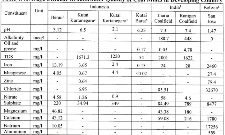
5.According to Table 3, sulfate, nitrate and pAHs
(oil
and grease) concentrations
in
effluent groundwaterof
coal mine
in
developedcountry
are about 33*14,565.2
me/|,
<0.2-125.3
me/l and
<0.5,respectively.
While,
the
concentrations
in developing country are smaller, they are about220-8477
m/l
of
nitrate, 0.9-58
mg/l
of
nitrate
and0.05-4.78
of
PAHs. However, the concentrationof
contaminant,
which
used
to
assess
loading contamination hazardin this
study, are analogizedby
the
highest
value
of
effiuent
groundwaterquality of coal mines
in
IndonesiaThe
contaminant
transport
in
first
step
andcontamination source strength
in
the
second step,are evaluated
by
matrix
evaluationto
obtain
thefinal
classification.
The
final
classification
of
stepwise process step
is
the potential groundwatercontamination
load
of
the
contamination source.Sulfate loading
contaminant,
pAHs
loadingcontaminant and
Nitrate loading
contaminant arepresented
in
Figure
6,
Figure
7
and Figure
g,respectively.
Table 2.
Natural
Groundwater
euality
of
CoalMine Area in Barito
Timur
]TDS Total Dissolve Solid
rCOD Chemical
Oxigen Demancl
rBOD Biological Oxigcn Demand
-184--lomponent LJn it
Guide
lrnc Val ucl
Sample Number
H-l H-2 H-3 H-4 H-5
:I I 6 5-8 7.2 7.3 1.04 689 7.01 rDST mgl l 000 t1+ 201 r08 68 51 3ODT m9l 0.2
0l
0.7 0.2 0.2loDl
mg/'l 5.1 3.9 4.4 45 5.2 ron msll 0.3 ) 0I 0.02 0.08 0.07 0.07 t4anganese mgil 0.1 ) 01 0 01 0.02 008 0.01lhloride ms/l 250 83 t2.4 6.23 10.3 623
'litratc mg/l 50 nla nla nla n/a nla
iulphate mgr'l 250 3.5 3.4 2.9 3.4
l.t
Magnesium mg/l 0.2 0.1
0I
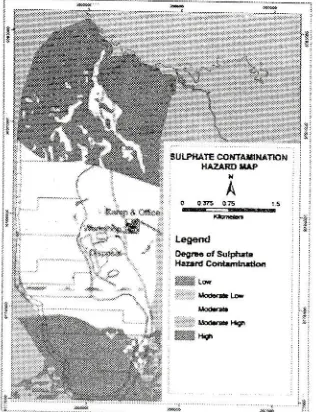
012 2.4 Calcium mC/l 103 10. I 6.04 16 1 604Groundwater Contamination Hazard
of
CoalMine Area in Barito
Timur
The results
of
the lulnerability
index and
eachcontaminant
loading
are
combined
in a
matrixevaluation
to
obtain
three
maps.
They
aregroundwater
sulfate hazard
map
(Figure
9),groundwater poly-aromatic hydrocarbon
hazardmap
(Figure
l0),
and groundwater nitrate hazardmap (Figure I 1).
Based
on the
degreeof
hazard
contamination,sulfate contamination hazard map
is
divided
intofive
classes
(low,
moderate
low,
moderate,Table 3.
Source
Pollution (Banks et aI,2003), 3underground water Impact Report (oakley creek coal pty Ltd,z}lz)
Table 4.
A
Effl
uentGround
Groundwater
Qualill of
Coal Minesin
DevelopingCount
Constituent Unit
lndonesia Indias Bolivias
Beraur Kutai Kartanegara2
Kutai
Kartanegarar
Kutai
Barat4
Jharia
Coalfield
Ranigan
Coalfield
San Jose pH 3.12 6.5 2.1 6.23 7.3 1A I.47
Alkalinity meq/l 188.7 448 0
Oil and
qrease mE/l 0.t] 0.05 4.78
TDS me/1 167 I 3 1220 54 200 r 1622
Iron mP/l 13.19 3.65 2.4 0. l3 24 28 2460
Manganese mg/l ,1.05 0.67 4.4 <0.02 27.1
Zinc mP/l 0.61 79.4
Chloride
mill
695 85.51 32670Nitrate
mill
4.5 8 1.26 0,9 58 4.6Sulphate mgl 220 34 94 349 84.49 789 8477
Magnesium
mill
46.82 43.38 r80Calcium mC/l 43 12 59 08 216 I 780
Natrium ms/l 10.05 17256
Aluminium ms/l 5s9
& Noviardy, 2010, and Development Ministq of Home Affair Republic of I
Source Data
:
tMarganingrum&
ndonesia,20l0 ,
rEnvironmental Management and Monitoring Report of PT. Tunas Sinar Abadi, 2012, aEnvironmentd Management and Monitoring
Reportof PT. Singlurus PratamaCoal,20125lmpactofCoal Miningin MineWaterQuality(Singh, 1988),6prediction of Watereuality
moderate
high and high)
poly-aromatichydrocarbons
(PAHs)
contamination
hazard
isdivided
into five
classes (negligible, low, moderatelow,
moderate, moderate
high),
then
nitratecontamination hazard
is
dividedinto
seven classes(negligible, low, moderate low, moderate, moderate
high, high, extreme).
Almost
all
concessionof
coal mine has probabilityof
sulfate contamination, as a resultof
acid minedrainage.
However,
the
nitrate
contaminationhazard
has
the
higher
degree
of
hazard contamination.rng
A
Effluent Groundwater
of Coal Minesin
Industrial
CounConstituent I lnit
Pennsyl ania' Norrvay2 UK2 Wales2 Australia3
\mstrong Clarion Kongens
Gruvc I-okkcn
Magpie
Sough Dunston Ynsarwed Morlais Queensland
pH 2 2.2 2.7 2.Il 7.2 6.3
6.9 669 Alkalinitv meq/l 0 0 0 0 4.28 374 2.76 6.01 2100
Oil and
grease ms/l <0.5
TDS msJl l5
I ron mP/l 2200 3200 134 4720 <0.00 05 10.6 180 26.6
0.94 Manganese mill 3.3 260 n/a nla <0.c002 1.26 6.1 0.93 0.28
Zinc me/l 363 81 .4 0 074 <0.007 0.061 <0.002 0.015
Chloride ms/l nla l9 26 32 25 6600
Nitrate me/l <0. I
Sulphate m9l r 4565 14000 901 t7036 JJ 210 I 554 455 2100
Magnesium mdl 590
Calcium mgl 47.8 330 98 645 222 64.5 270
Natrium
m/l
n/a nla 8 51.4 109 155Aluminium mill 33.1 s80 0 00s <0.045 <0.5 <0.01 0.004
Data
:
' Prediction of Water Quality at Surface Coal Mines 2000)'ZGeochemical Processes Mat Surface Coal Mines (Kleinmann,2000)
ble
T
able 5. Assessment of loading contamination hazard of coal mine areain Barito
Ti
No. Type of Contaminant Nitrate PAHs
Sulphate
I Class of Contaminant
Contaminant
Nlohilitv Ver,v liigh Low High
Attenuation of
Contaminant Very Lorv Moderate Lorv ) Intensity of
Contaminant
Concentration of
Contaminant Lorv (.1.58 nrgll) Lorv (0.17 rrgrl) Low (3,19 mg/l)
Proportion of
recharge DilTuse (>l[)%) NlLrltipoint (1 - l0 9./o) Dilf usc (> 1 0%)
3 Mode of
Dispotion
Hydraulic Load Moderate (l-10 mntl,d) N'loderate(0.1 - l0
mmrd) iligh ( I 0-l 00 nrnr/d)
Discharge Position Moderatc (LJnsaturated
zone) Deep (saturated zone) Moderate z0ne (l lnsaturated
)
4 Duration of
Application
Duration t.ong (Decade) Short (flour to Da),) Short (Da1, to Month)
Probability of Load I'ligh (60-100%) L.orv (0-25%) N,loderatc (30-7Oyo)
ilii:l,5ll$i 'ffi
qrLP[rTELOaooaG , ] coilIAHHAr t,AP j :
i :!
A
':a 036 0d r,: ,r :: ffi :i trgand
€l* ol sufFae L6drB hrd.t
stffi h iir::ri*mry'
Figure
6. Sulfate LoadingContaminant Map
Figure 8.Nitrate
LoadingContaminant Map
3ul'ruE@frMUmX ffire
bdCffi
w6
Figure 9. Sulfate
Contarnination
FlazardMap
HITRAT LOAOIXG
CONTAMIUT MAP
A
-::::::::-Log.nd
Figure 7. PAHs
Loading Contaminant Map
-
186,',:
Pdrcoaftmrm t{gmre
A oosoB
Lesrld
Cell.htu Iffiffi
,1i:.i1::io
li-it:Ste Wdee
Figure
10.PAH Contamination Hazard Map
Oo*OB L.!ed hscdHfr Cd&lltd
ffiw
li:iii:ii:,rgq
We*
Figure
1I.
Nitrate Contamination Hazard Map
CONCLUSIONS
Open
pit
coal
mine
has
many
impacts
ongroundwater
quality.
Hence,
an
EnvironmentalImpact
Assessmentis
required
as paft
of
theauthorization
process.Groundwater
contaminationhazard
assessment ensuresbetter
considerationof
environmental
impacts
on
groundwater
quality,caused
by
open
pit
coal mine.
By
groundwatercontamination hazard,
in
study
area,a
groundwaterprotection management can be developed. Based on
the
hazard
of
contaminant(sulfate,
poly-aromatichydrocarbon and nitrate),
it
can be conclude that thelargest
probability
of
contamination hazardin
studyarea
is
sulfate,
which
is
generatedas acid
minedrainage reaction
in
environment. While, the highestlevel
of
contamination hazardis
nitrate.In
addition,the highest hazard of groundwater contamination area
will
be occun'edat
North
of
coal
mine concession,which may
reach
to
groundwater. Therefore, themitigation
and
protection
management
inEnvironmental In.rpact Assessment document
rvill
beconcemed there. This
is
a preliminary assessmentof
groundwater contamination hazard,
which is
appliedin
coal mine area as a partof
Environmental IntpactAssessment,
thus
further comprehensive research isneeded to complete this study.
REFERENCES
Aller.
L.. Bennet, T., Lehr, J. H., petty. R. J., Hackett,G.,
DRASTIC;
A
Standardized
S);srem .forEt'aluating
Groundtt.ater
pollution
potentialusing
Hydrogec.tlogical Settings.EpAi600i2-87i035.
US
Environmental protecrion Agency,usA
(1e87).Banks
et al,
Geochemical proces.s
Controllingl.,linewater
Pollution,
proceeding
of
the
2idIMAGE-'IILAIN
Advanced Studv Course. pecs.Hungary. June 23 -27 (2003).
Brady,
et
al.,Hov,
Gec.tlog, AlJbcts iv{ine DrainugePrediction,
in
Kleinrnen,R.L.p
(ed1, predictionof
l|/ater Quality
at
SurfaceCoal Mines,
TheNational
Mine
Land
Reclamation
CenterLocated
at
West Virginia
Universitr,
in Moranrown. West Virgirria t20001.Civita,
M.
andDe
Regibus.C..
Sperimentazionetli
alcttne
metdologie
per
la
t:alutazione
clellavulnerabilitd
degli
aqui,fer.
a
Geol
ApplPitagora Bologna
3:63-71
(1995).Chilton, .1..
Schrnoll.
O and
Applevard.
S.,Assessment of Groundv,ater
pollution
potential.ln:
Scntoll,
O,
Hott'ard,
G,
Chilton.
J
antlChorus,
I.
(ed)
Prole(:tit1g Grotutchtater JbrHeulth:
Mctnagingeuatity
o.fDrinking
ll.oterS,trrctr. WHO
Drinking
earer
eualitr
Serie. (2006)Cornie
llo. A.,
Ducci,
D.,
and
Napolitano.
p...Comparison belvteen
parantetric
ntethocl.s loeyaluote
aqtti/br pollutictrt
tulnerubility
u.singG1S:
o,,,ronr1ri,
in
the
piana
Clntpurt,
,\ottlhern [tal],.
ln'
Lfarino.r
p.,
Koukis
G..Tsiambaos
G.,
Stournttrus
G.
(Eds).Engineering
Geology and
the
E,nvironmental.Balkerna, Rofterdarn,
l72l-1j26
( 1997).Daly'.
D.,
Dren,.D.. Irish
Methoclologies.for
Karst.4quifer
Protection.
In.
"Hr-drogeolog,
andengineering geolctg. of sinkholes and karst (.ed.;..
Beek
B.
Balkerna- Rotrerdarn,
pp.267_272( I eee).
Foster,
S..
and Hirata,
R..
Grottndu,aterpollution
R/.rf
Assessment,...1
Ltethctdolog.
U,sing.lvtil,thlt
l).rl.r. PAN
American
Cenler
ForSanitary
E,ngineering
and
Environmental Sciences (CEPIS). Lirna. peru(l9gg).
Javadi.
5.. ,)fotl(ictttiott oJ
DR.ISTIC il4r.tdelto
fulap(jrotrrtdttoter
L'ulnerabili4,to
pollution
[,,singNitrate
l,leasurenrentain
Agriatltural
Areas,Journal
of Asricultural
Science and Technology,. 13, pp.23e-219 (201 I ).Johansson.
P.-O,
and
Hirata.
R..
Rating
o.f(iroundu,ater Contaminant
Source.s,
inZaporosec. (ed1, Groundw,ater Contamination
Irrt,enton,:
A
llethodo/ogical
Guide.
IHp_VI.-iB7-GlItSTlS-31 ffull paDErl
Series on Groundwater
No. 2,
UNE,SCO, p.63-74 (2002).Lerner,
DN..
Identtfiing and Quantifi,ing
Urban Recharge: .4 Review, Hydrogeology Journal, 10,pp. I 43- I 52 (2002).
Marganingrurn D
&
Noviardi R, PencentqranAir
dan Tanahdi
Ku*-usan Pertambangan Battrbara diPT.
Berau
(loal,
Kalimantan Timur,
RisetGeologi
dan PertambanganVol. 20 No.
l,
pp I I -20 (20 I 0).Morris,
B.L.,
Larvrence,A.
R.,
Chilton,
p.J.C..Adains,
B.,
Calow, R.C., and Klinck.
B.A.Groundtvater
and irs
sttsceptibility*
todegradation:
A
globol
assessmentoJ.
theproblem
and
oTttionsJbr
ruanagement. F.arlvWaming and Assessment Repoft Series, RS.
03-3.
United
Nations Environment
program,Nairobi, Kenya (2003).
Nonner, J. C., Scnrce of Groundwater Cohtantinution,
in Zaporo;-ec
kd),
Grrnndvtuter C ontomindt iL)nlnventory:
A
Methodologicul Guide. IHp-VI,
Series on Groundwater No. 2, UNESCO, p. 23-38 (2002).Piyrnale,
C.
L.,
Angle,M.
P.,Groundtt,aterpollution
potential
o.f
Fulton
Coun4,,
Ohio.
OhioDepartment
of
Natural
ResourcesDivision of
Water, Water Resources Section. Groundrvater
Pollution Potential, Report No. ,15 (2002).
Putra,
D.P.E,
The lmpacl
of
Llrbctnization
onGrotrndv,ater
Quality,
A
Case Study
inYog:akarta Ciy-
-
Indonesla, Mitteilungen zurlngenieurgeologie und Hydrogeologie,
Heft
96,148 S, Okt 2007, Herausgegeben vorn Lchrstuhl
fuer
Ingenieurgeologie
und
Hydrogeologie,Univ.-Prof.
Dr.
R.
Azzatn,
RWTH
Aachen. Germany (2007).Raden et al, Kajian Dampak Penantbangan Batubara
Terhodap Pengentbangan Sosial Ekonomi clon
Lingkungan
di
KabupatenKutui
Kartanegara,Research and Developrnent
Ministry
of
HorneAlfair
Ilepublic of lndonesia (2010).Sineh, Gurdep,
Impoct
of
Coctl
ltlining
ott
llfineWater Quality. Intentational
Journalof
MineWater,
Vol.7. No.3.
pp..19-59 (1988).Vbra.
J.,
Zaporosec,,,l.
Guidebr.tokon
lllupping(jroundy,ttter
L'ulnerohility.
InternationalAssociation
of
Hydrogeologist
(lntenrationalContributions
to
Hydrogeoiogy
l6).
Verlag Heinz Heise, Hannover ( 1994).\Vorld llealth
Organization(WHO).
Guidelines forDrinking Water Qualit1,,
Vol.
I :3'd ed. (2004).---.
En"-ironmental l.lanugementantl llonitoring
Report,
PT.
'funas Sinar Abadi.
KutaiKananeglra (2011,).
---,
Enyironmenlal Munttgententand
MoniloringReport.
PT.
Singlurus pratanta
Coal.
KLrtaiBarat. (2012).
---,
[indet.grouttl
LYctterIntpact
Report, Oakley Creek Coal Pty, Ltd. eueensland (2012).