TROPICAL AGRICULTURAL SCIENCE
Journal homepage: http://www.pertanika.upm.edu.my/
Article history:
Received: 18 August 2017 Accepted: 28 June 2018 Published: 29 August 2018 ARTICLE INFO
E-mail addresses:
[email protected] (Yurike) [email protected] (Yonariza)
[email protected] (Rudi Febriamansyah) [email protected] (Syafruddin Karimi) * Corresponding author
Land Use Changes in Dharmasraya District, West Sumatra,
Indonesia
Yurike1, Yonariza2*, Rudi Febriamansyah2 and Syafruddin Karimi3 1Department of Agricultural Sciences, Graduate Program, Universitas Andalas,
Padang, 25163 West Sumatra, Indonesia
2Department of Agricultural Socio Economic, Faculty of Agriculture, Universitas Andalas,
Padang, 25163 West Sumatra, Indonesia
3Department of Economics Studies, Faculty of Economic, Universitas Andalas,
Padang, 25163 West Sumatra, Indonesia
ABSTRACT
Deforestation in the tropics is having significant ecological, economic and social impacts (global warming, biodiversity loss, respiratory problems, flooding). Previous research has indicated a close relationship between poverty and deforestation. This study was motivated by high deforestation rates in Dharmasraya, West Sumatra, Indonesia and a desire to test the assumption that poverty was driving this. Using a mixture of primary and secondary data and drawing heavily on 250 interviews with households living in and around the forest in Dharmasraya, this study describes the context, the forest clearing technique used by households, and analyses what drives deforestation in Dharmasraya. The findings showed that people had cleared as much as 80% of the forest using slash-and-burn techniques. Hotspots were observed from the NOAA satellite. It was found that deforestation in Dharmasraya was driven by middle-class households who control land with an average of 14.97 ha. This finding is significant because it suggests that a forest-related development programme should benefit society economically and socially, the latter in terms of awareness of the importance of protecting the forest because of its ecological functions.
Keywords: Development programme, hotspots, slash and burn technique, society
INTRODUCTION
or anthropogenic causes, temporary or permanent, and either legal or illegal conversion of land (Forest Watch Indonesia, 2014). Although tropical deforestation continues to the present day, the protagonists are changing. Previously the state and private sectors were dominant actors, whereas now households are increasingly playing an active role.
Most Asian countries have seen mass-deforestation (> 70%), Indonesia and Malaysia in particular, have seen rapid deforestation (Laurance, 2007). Deforestation in Indonesia is partly caused by widespread poverty and the conversion of the forest by the small-scale farmers. However, this is inversely proportional to deforestation in this case study at Dharmasraya.
Dharmasraya district in West Sumatra, Indonesia has 302,958 ha of forest or 31.12% of total forest cover in Indonesia. The Ministry of Forestry Decree No. SK.695 / Menhut-II / 2013 dated 21st
October 2013 established the Production Forest Management Unit (PFMU) in Dharmasraya covering an area of 33,550 ha. Forest coverage within this PFMU has declined by 27,216.57 ha in recent years. Administratively, this PFMU area is the state forest which was awarded a timber concession licence by the government from 1972 to 2002. The high rate of deforestation occurred after the license ended.
There is a forest tenurial conflict where the local community claimed this land as their communal land while in the other FMU areas in Indonesia, land occupation occurred
due to weak forest management and people’s need to earn a living. In the Dharmasraya PFMU the land has been occupied and traded for investment. However, forest exploitation in FMU Dharmasraya did not occur spontaneously. It is because in PFMU areas, customary regulations still apply, requiring all communities, and others wishing to manage forests to seek permission from their customary law functionaries. There is a conflict in terms of forest land ownership (Mutolib, Yonariza, Mahdi, & Ismono, 2017) and a new approach of forest encroachment occurs systematically and structurally where formal power holders seek to gain benefits from a vacuum in forest management.
Since 2000, these local communities have gradually converted forest land into oil palm and rubber plantations. Although according to the Government Regulation No.6 of 2007, converting forest land into rubber plantation is still allowed because rubber trees can be categorised as forest plants (Ministry of Forestry, 2007), but not those of oil palm. Based on that regulation, the unproductive forest in this study site has been transformed by local communities into productive rubber plantations.
The official rights to the PFMU land were actually given to the government-owned forest company (called INHUTANI) to convert that forest into industrial forest by enriching a specific kind of plant that is
Dipterocarpaceae trees. Unfortunately, the
for a long period. However, the local communities have replaced rubber trees with oil palm which is not included in the category of forest plants. This was mainly due to the steady decline in rubber prices, while the price of oil palm is promising.
Forest and land rehabilitation is an effort to restore, maintain and improve the function of forests and land so that the carrying capacity, productivity and its role in life supporting system are maintained (Ministry of Forestry, 2008). Rehabilitation must work in tandem with changing the local community’s behaviour. Yet, the factors influencing this behavior are not well understood and many forest rehabilitation programmes failed. It is clear that the factors contributing to this land use change are complex. The relationship between forest clearing and household variable are varied and depends on its management(VanWey, Ostrom, & Meretsky, 2005).
Moonen et al. (2016) concluded only few studies examined the motivation for deforestation due to lack of consistent datasets, especially in the local context. Kaimowitz and Angelsen(1998) reviewed more than 150 cases of tropical deforestation using an economic model. They criticised the multi-nation research due to its low data quality(Moonen et al., 2016). They also found a variety of reasons for deforestation and suggested the need to carry out research at the local level. In addition, Kaimowitz and Angelsen(1998) found that the land market was one of the main uncertainties that could be solved only by further research. This study helps fill this gap.
The paper argues the deforestation in Dharmasraya is strongly related to the role of the households in the forest. Therefore, it is important to find out the characteristics of households contributing to high deforestation rates. The present research examines the forest condition in Dharmasraya, clearing techniques used by the people, and analyses the drivers of deforestation drivers.
MATERIALS AND METHODS
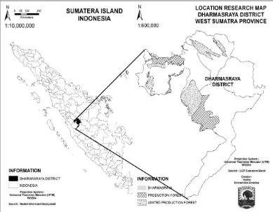
This research was conducted from April to October 2016 in the Production Forest Management Unit (PFMU) Dharmasraya in West Sumatra Province, Indonesia. The study used descriptive method based on a survey. It used various data collection techniques, such as observation, secondary data collection, documentary, historical data, key informants, and household survey. Figure 1 indicates the research site.
Respondents were the households encroaching on the forest land. There are no accurate data about how many encroachers are in the PFMU are, either locals or those from other surrounding villages. This makes it impossible to determine the population of the encroacher. Therefore, this study used a snowball sampling technique (Thompson, 2002). Preliminary visits were made to areas within PFMU Dharmasraya to identify locations where local people clear the forest. We identified encroachers in the following locations; Bulangan, Sungai Jernih, Bukik Gadang, Sungai Likian, km 25, Sakaladi,
Bukik Batu Basalai, Sungai Siek. The
owners of plot near their land. Overall, there were 250 respondents interviewed from various villages who occupied forest land.
Research variables were livelihood of respondents, plant type, road access condition, land cover change, forest clearing techniques used by households, asset ownership, forest fire hotspots, farmer’s land occupation history (year), and size of land (ha). The data were analysed using descriptive quantitative statistics (Williams, 2007) by describing the collected data without generalising the findings (Sugiono, 2012).
RESULTS
Salient Features of Dharmasraya District
Dharmasraya is a district level administrative unit in West Sumatra Province, established in 2004. The current Dharmasraya District Government forest management strategy is a legacy of the previous administration. However, deforestation has increased during the current administration.
The trans-Sumatra highway passes through Dharmasraya and this district is located at the intersection of roads linking various cities in Sumatra Island, i.e., Padang the capital of West Sumatra,
Pekanbaru capital of Riau Province, and Jambi Province. One third of the district’s population are migrants from various regions, who resettled in this area and opened new businesses. Previously, this area was still largely covered by forest. In 1979, the government sponsored a resettlement programme known as transmigration. In the first year, immigrants initially only relied on government allocations. After the aid ended people began to move to the plantation.
Most of the land use in Dharmasraya District is for agricultural purposes (89.98%). The plantation area is the largest with an area of 153,822 ha or 51.95% of the total area of Dharmasraya District, while land for rice field is 6,666.8 ha or 2.25% and community forest area is 61,274.8 ha or 20.69%.
Based on the research results, the occupation of forest encroachers are farmers (55.6%), entrepreneurs (18.8%), military personnel (2.8%), employees (20.0%), or have other occupations (2.8%). This showed that for 47.2 % of the respondents were not farmers, where gardening is an investment for them and not their main source of income. Those who have more financial capital tend to outsource the cultivation of their land.
Condition of the Forest
Dharmasraya forest is dry land forest with wet tropical rain forest on undulating areas. The Dharmasraya PFMU is home for about 80 species of plants. There is no competition among the species. The dominant species are Meranti (Shorea leprosula), Medang (Litsia
firma), Sikubung (Litsea cubeba), Kelat
(Xylopia altissima), Balam (Palaquium
walsurifolin),Mempening (Quercus lucida),
Arang-arang (Diospyros puncticulosa),
Mahang (Macaranga hypoleuca), and
etc. The tree species in this forest include rare species with small growing potency (Production Forest Management Unit, 2014).
The forest in Dharmasraya is relatively flat lowland forest (steep areas account for 11.8% of the forest, flat areas for 48.2%, and sloping areas for 40.1%). The area is easily accessible and only requires a low investment cost. Undulating parts of the PFMU are located near settlements, and it is easy to access the forest to harvest timber. More than half of the areas have been converted into plantation, the rest is secondary forest (logged over forest) and newly cleared areas.
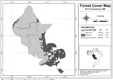
The forest is easily accessible. A high demand for land, especially from newcomers, has intensified people’s interaction with the forest. The economic activities within the PFMU areas are rubber and oil palm plantations. During the early stage of the rubber planting, the farmers also grow chilli and peanuts. The high interaction between people and forest has caused massive encroachment in PFMU areas (Figure 2 and Figure 3).
Figure 2. The extend of various forest cover in 2005
such as bridges and road to ease access to plantations in designated forest areas. The easy access obviously influences the forest cover. The negative effect is the loss of forest areas(Caliskan, 2013). This forest conversion, in turn, also affects the environmental and water management in Dharmasraya. It may cause Dharmasraya to be at high risk of environmental hazards, such as floods and soil erosion.
Land Clearing Technique
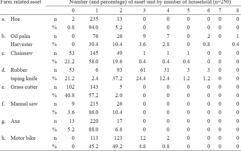
Communities surrounding the forest land are closely related to the utilisation of forest sources. This association can be seen from their existing assets (Table 1). Household assets that facilitate the plantation in the forest areas, including the possession of working tools, are shown in Table 1.
All farming households have, at least, one motorcycle, giving them easy access even though the distance to the forest can be more than 20 km from their settlement. They also have machinery for forest clearing such as chainsaw. For the rubber farmers, each household has supporting tools such as taping knives. These assets are used to clear forest land for plantations.
Encroachers who have more financial capital tend to outsource work force to cultivate their land. Despite 47.2% of them not being farmers, the encroachers have agriculture tools and machinery needed to support their own plantations. The plantation is also managed by members of their family as well as by outside workers.
In regard to forest land clearing techniques, the local community in
Farm related asset Number (and percentage) of asset unit by number of household (n=250)
0 1 2 3 4 5 6 7 8
a. Hoe n 2 235 13 0 0 0 0 0 0
% 0.8 94.0 5.2 0 0 0 0 0 0
b. Oil palm n 0 76 26 9 7 0 2 0 1
Harvester % 0 30.4 10.4 3.6 2.8 0 0.8 0.4
c. Chainsaw n 53 145 49 1 1 1 0 0 0
% 21.2 58.0 19.6 0.4 0.4 0.4 0 0 0
d. Rubber n 53 6 93 61 31 3 3 0 0
taping knife % 21.2 2.4 37.2 24.4 12.4 1.2 1.2 0 0
e. Grass cutter n 102 143 5 0 0 0 0 0 0
% 40.8 57.2 2.0 0 0 0 0 0 0
f. Manual saw n 9 215 26 0 0 0 0 0 0
% 3.6 86.0 10.4 0 0 0 0 0 0
g. Axe n 13 220 17 0 0 0 0 0 0
% 5.2 88.0 6.8 0 0 0 0 0 0
h. Motor bike n 0 113 123 12 2 0 0 0 0
% 0 45.2 49.2 4.8 0.8 0 0 0 0
Table 1
Dharmasraya usually use the slash and burn technique. This method has been used for agricultural purposes, especially in plantation development (Yukili, Nuruddin, Adnan, Malek, & Razali, 2016). Initially, the big tree stands were cut and the timber sold. The remaining tree branches were cleared or left to dry naturally. The slashing uses axes, choppers and chainsaws. Vegetation drying rates depend on the season. They usually clear the land during the dry season when the remaining tree branches can be left to dry for a few days and then burned. The remaining
biomass is then cleared after the fire is out. The remaining tree branches are also used as a hedge or for firewood.
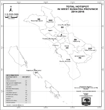
The local communities in Dharmasraya have been using this technique for a long time. The main reason for using the slash-and-burn technique is because it is simple, fast and practical. Forest fires are observed through the NOAA satellite and recorded by the West Sumatra Forestry Department. For example, the high number of forest fires spots from 2014-2016 is shown in Figure 4.
Forest fires are common in Dharmasraya in order to make way for plantations. The slash and burn technique has negative effects, such as environmental impacts on water supply, flooding, biodiversity loss and social effects. There are some negative effects of slash and burn including ecological (Goswami, Choudhury, & Saikia, 2012), land structural damage (Thomaz, 2017), and sedimentation risk (Wagenbrenner, Robichaud, & Brown, 2016). It also decreases soil quality and changes the soil structure in ways that lead to lower agricultural productivity (Tabi, Mvondo, Boukong, Mvondo, & Nkoum, 2013). N and P concentrations decrease after 3 years of slash and burn cultivation (Gay-des-Combes et al., 2017).
Deforestation Drivers at the Household Level
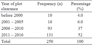
Forest clearing has increased over the last 10 years as shown in Table 2. There is a connection between the closure of timber concession and the time when local people begin clearing the forest for the small holder plantation. It was the time when the last forest management ended.
Table 2
Number of respondents by history of Smallholders’ establishment Inside Forest Land
Year of plot clearance
Frequency (n) Percentage (%)
before 2000 10 4.0
2001 – 2005 16 6.0
2006 – 2010 93 37
2011 – 2016 131 52
Total 250 100
According to local land tenure system, the forest is a communal property or ulayat
land that is passed from one generation to the next in the Dharmasraya community. However, in 1972, the government granted timber concession to Ragusa Ltd covering an area of ± 66,000 ha. Then in 2002, the license to this company was revoked by the government because they did not perform as expected. After 2002, a portion of this concession area was given to three plantation companies, namely PT. Incasi Raya, PT. SMP dan PT. AWB, to convert half of this forest land into oil palm plantations. Another portion of the forest concession area was given to three other forest companies (PT. Inhutani, PT. Dara Silva, and PT. Bukit Raya Mudisa) for industrial forestry uses.
PT. Ragusa actually left their forest concession area unmanaged prior to revoking of timber concession in 2002, and the local communities started claiming their traditional rights over forest land for their own benefits. They used the stub roads built by PT Ragusa to go deeply to the forest area for their own purposes. Table 2 shows the increase in local communities who taken over the forests use in this region since before 2000 up to 2016. They claimed these forest areas are their ulayat (indigenous customary rights). Currently, those local communities have planted most of these forest areas with oil palm and rubber.
forest from the government, they still need to seek permission from the ulayat
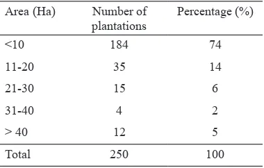
leader. This caused conflict between the investors and ulayat leaders that resulted in ineffective work by the company which has a government licence (Mutolib, Yonariza, Mahdi, & Ismono, 2016; Yonariza, Mutholib, & Yurike, 2015; Yurike, Yonariza, Febriamansyah, & Karimi, 2015). The more local communities occupied the forest for their own purposes, especially small-holders, the more difficult for the licensed companies to use their right to develop plantations. Table 3 shows the size of smallholder plantations in the forests that have already have government licence. This is the main factor causing forest degradation in this study site.
Area (Ha) Number of
Size of smallholder plantation area
selling land, clearing an area of 10 ha with the intention of selling half of it to establish smallholder plantation. This clearly shows that plantation development is motivated by monetary factor although its economic value is much lower than that of conserving the forest (Ghani, Haron, Nor, Nuruddin, & Ahmad, 2007) if assessed from the overall economic value of the forest.
DISCUSSION
The findings of this study are consistent with others on the causes of deforestation. As suggested by Wunder (2000) and Kanninen et al. (2007), the main cause of deforestation is open access to forests. Chomitz, Buys, De Luca, Thomas and Wertz-Kanounnikoff (2007) added that road access is a major factor in deforestation. This is the situation in Dharmasraya where access road was provided by the former concession companies, making it easier for people to access the forest.
The finding of this study is also similar to that reported by Medrilzam, Dargusch, Herbohn and Smith (2014) who found that forest degradation in tropical peat land in Central Kalimantan, Indonesia was mainly triggered by community livelihood activity. However, this study also found another driver of change including uncertainty of land tenure, such as land right claims by the community based on customary law. Overlapping land right claims, like in Dharmasraya, reflect the weakness of existing law enforcement. This promotes the community to clear the land which leads to a significant decrease of forest cover. Mostly the respondents (74%) have
Findings of the present study on the cause of deforestation at the household level are different from those reported by Zwane (2007) who studied the relationship between poverty and forest clearing in Peru. Zwane (2007) concluded that a small increase to household income will reduce deforestation. The government believes that it is important to increase household income to slow down the deforestation rate(Chomitz & Kumari, 1998). A similar case was reported by Miyamoto, Parid, Aini and Michinaka (2014), who look at poverty in Peninsular Malaysia poverty as a major factor leading to deforestation. The Dharmasraya case is different because many of the encroachers are middle-class people. This can be seen from the ownership of assets and the area of land cleared by households. The middle-class households are active in forest clearing.
These findings filled the research gap (Kaimowitz & Angelsen, 1998) but there is a need for more research at the local level. Moneen et al. (2016) stated relevant local context-specific information is needed for policy makers to design efficient, effective and equitable policies. This research helps fill the gap in information at the local level in Dharmasraya.
CONCLUSION
The physical changes in the forest area of an ex-forest concession in PFMU Dharmasraya areas contributed to a significant decrease in forest coverage. The forest encroachers in Dharmasraya are middle class people
who use a slash and burn approach for clearing the forest. There is a need for forest development programmes that not only improve income of the local community but also people’s awareness of the importance of protecting the forest to improve its ecological function throughout the tropical region.
ACKNOWLEDGEMENTS
The authors owe a debt of gratitude to the Ministry of Research, Technology and Higher Education in the Republic of Indonesia for funding support for this research under the Program Magister
Menuju Doktor Sarjana Unggul (PMDSU),
an accelerated Ph.D. program, under Grant No. 01 /UN.1 6/PL-PMDSU/2014. Thanks also to Richard James Stanford, the language editor for this paper. The authors also thank Universitas Andalas for its support in executing this research, such as travel grant to support the corresponding author’s participation in the XVI Biennial Conference of the International Association for the Study of the Commons, Utrecht, The Netherlands, July 20-14 2017.
REFERENCES
Caliskan, E. (2013). Environmental impacts of forest road construction on mountainous terrain.
Journal of Environmental Health Science and Engineering, 10(23), 1–8. doi:
10.1186/1735-2746-10-23.
Chomitz, K. M., Buys, P., De Luca, G., Thomas, T. S., & Wertz-Kanounnikoff, S. (2007). At loggerheads? Agricultural expansion, poverty reduction, and environment in the tropical forests. Washington, DC: World Bank.
Forest Watch Indonesia. (2014). Potret keadaan hutan Indonesia periode 2009-2013 [Portrait of Indonesia’s forests period 2009-2013]. Bogor, Indonesia: Forest Watch Indonesia. Retrieved from http://fwi.or.id/wp-content/ uploads/2014/12/PKHI-2009-2013_update.pdf
Gay-des-Combes, J. M., Robroek, B. J. M., Herve, D., Guillaume, T., Pistocchi, C., Mills, R. T. E., & Buttler, A. (2017). Slash-and-burn agriculture and tropical cyclone activity in Madagascar: Implication for soil fertility dynamics and corn performance. Agriculture, Ecosystems & Environment, 239, 207-218. doi: 10.1016_j.
agee.2017.01.010.
Geist, H. J., & Lambin, E. F. (2002). Proximate causes and underlying driving forces of tropical deforestation. BioScience, 52(2),
143-150. doi: https://doi.org/ 10.1641/0006-3568(2002)052[0143:PCAUDF]2.0.CO;2. Ghani, A. N. A., Haron, H., Nor, K. M., Nuruddin, A.
A., & Ahmad, I. (2007). Valuing the rain forest: The economic values of selected forest goods and services in Ayer Hitam Forest Reserve, Puchong, Selangor. Pertanika Journal of Tropical Agricultural Sciences,30(2): 141-152. Goswami, K., Choudhury, H. K., & Saikia, J. (2012).
Factors influencing farmers’ adoption of slash and burn agriculture in North East India. Forest Policy and Economics, 15, 146–151. doi:
10.1016/j.forpol.2011.11.005.
Kaimowitz, D., & Angelsen, A. (1998). Economic Models of Tropical Deforestation: A Review. Bogor, Indonesia: Center for International Forestry Research. Retrieved from http://www. cifor.org/publications/pdf_files/Books/model. pdf.
Kanninen, M., Murdiyarso, D., Seymour, F., Angelsen, A., Wunder, S., & German, L. (2007). Do trees grow on money? The implications of deforestation research for policies to promote REDD. Bogor,
Indonesia: Center for International F o r e s t r y Research.
Laurance, W. F. (2007). Forest destruction in tropical Asia. Asian Biodiversity Crises, 9(11),
1544-1550.
Medrilzam, M., Dargusch, P., Herbohn, J., & Smith, C. (2014). The socio-ecological drivers of forest degradation in part of the tropical peatlands of Central Kalimantan, Indonesia. Forestry, 87(2),
335–345. doi: 10.1093/forestry/cpt033.
Ministry of Forestry. (2007). Peraturan Pemerintah Republik Indonesia Nomor 6 Tahun 2007 tentang tata hutan dan penyusunan rencana pengelolaan hutan, serta pemanfaatan hutan [Government Regulation of the Republic of Indonesia No. 6/2007 concerning forest management and preparation of forest management plan, and forest utilization]. Jakarta, Indonesia: MoF Republic of Indonesia.
Ministry of Forestry. (2008). Peraturan Pemerintah Republik Indonesia Nomor 6 Tahun 2007 tentang rehabilitasi dan reklamasi hutan [Government Regulation No. 6/2007 on forest rehabilitation and reclamation]. Jakarta, Indonesia: MoF
Republic of Indonesia.
Miyamoto, M., Parid, M. M., Aini, Z. N., & Michinaka, T. (2014). Proximate and underlying causes of forest cover change in Peninsular Malaysia.
Forest Policy and Economics, 44, 18–25. doi:
10.1016/j.forpol.2014.05.007.
Moonen, P. C. J., Verbist, B., Schaepherders, J., Meyi, M. B., Rompaey, A. V., & Muys, B. (2016). Actor-based identification of deforestation drivers paves the road to effective REDD + in DR Congo. Land Use Policy, 58, 123–132.
Mutolib, A., Yonariza, Mahdi, & Ismono, H. (2016). Gender Inequality and the Oppression of Women within Minangkabau Matrilineal Society: A Case Study of the Management of Ulayat Forest Land in Nagari Bonjol, Dharmasraya District, West Sumatra Province, Indonesia. Asian Women, 32(3), 23-49.
Mutolib, A., Yonariza, Mahdi & Ismono, H. (2017). Forest Ownership Conflict Between A Local Community and The State: A Case Study In Dharmasraya, Indonesia, Journal of Tropical Forest Science, 29(2), 163–171.
Production Forest Management Unit. (2014). Long-term forest management plan 2015-2025.
Dharmasraya, Indonesia: Production Forest Management Unit.
Rosa, I. M. D., Smith, M. J., Wearn, O. R., Purves, D., & Ewers, R. M. (2016). The environmental legacy of modern tropical deforestation. Current Biology, 26(16), 2161-2166. doi: 10.1016/j. cub.2016.06.013.
Sugiono. (2012). Mixed Methods. Bandung, Indonesia:
Alfabeta.
Tabi, F. O., Mvondo, Z. A. D., Boukong, A., Mvondo, R. J., & Nkoum, G. (2013). Changes in soil properties following slash and burn agriculture in the humid forest zone of Cameroon. African Journal of Agricultural Research, 8(18),
1990-1995. doi: 10.5897/AJAR12.1713.
Thomaz, E. L. (2017). Fire changes the larger aggregate size classes in slash-and-burn agricultural systems. Soil and Tillage Research, 165, 210-217. doi: 10.1016/j.still.2016.08.018. Thompson, S. K. (2002). Sampling (2nd ed.). New
York: John Wiley & Sons.
VanWey, L. K., Ostrom, E., & Meretsky, V. (2005). Theories underlying the study of human-environment interactions. In E. F. Moran, & E.
Ostrom (Eds.), Seeing the forest and the trees: Human-environment interactions in forest ecosystems (pp. 23-56.). Cambridge: MIT Press.
Wagenbrenner, J. W., Robichaud, P. R., & Brown, R. E. (2016). Rill erosion in burned and salvage logged western montane forests: Effects of logging equipment type, traffic level, and slash treatment. Journal of Hydrology, 541,
889-901.doi: 10.1016/j.jhydrol.2016.07.049.
Williams, C. (2007). Research methods. Journal of Business & Economic, 5(3), 65-72.
Wunder, S. (2000). Economics of deforestation: The example of Ecuador (St. Antony’s series). UK: Palgrave Macmillan.
Yonariza, Mutholib, A., & Yurike. (2015). Negotiating with land owners for forest restoration in Indonesia: A case from Dharmasraya District, West Sumatra, Indonesia. National Conference on Management of Natural Resources and Environment. Diponegoro University, Indonesia.
Yukili, L., Nuruddin, A. A., Adnan, I., Malek, I. A. A., & Razali, S. M. (2016). Analysis of hotspot pattern distribution at Sabah, Malaysia for forest fire management. Journal of Environmental Science and Technology, 9(3), 291–295. doi:
10.3923/jest.2016.291.295.
Yurike, Yonariza, Febriamansyah, R., & Karimi, S. (2015). Land grabbing and deforestation: C o m m u n i t y p e r c e p t i o n o n f o r e s t l a n d ownership in Dharmasraya District, West Sumatra, Indonesia. Proceedings of Land
grabbing, conflict and agrarian-environmental
transformations: Perspectives from East and Southeast Asia, Chiangmai, Thailand: BRICS
Initiatives for Critical Agrarian Studies (BICAS).
Zwane, A. P. (2007). Does poverty constrain deforestation? Econometric evidence from Peru. Journal of Development Economics, 84,