Environmental Science and Engineering
Environmental Science
Series Editors
Rod Allan Ulrich Förstner Wim Salomons
For further volumes:
Fawu Wang
•Masakatsu Miyajima
Tonglu Li
•Wei Shan
•Teuku Faisal Fathani
Editors
Progress of Geo-Disaster
Mitigation Technology
in Asia
Editors
Institute of Engineering Geology Explora Northeast Forestry University
Harbin
People’s Republic of China
Teuku Faisal Fathani
Department of Civil and Environmental Engineering
Universitas Gadjah Mada Yogyakarta
Indonesia
ISSN 1431-6250
ISBN 978-3-642-29106-7 ISBN 978-3-642-29107-4 (eBook) DOI 10.1007/978-3-642-29107-4
Springer Heidelberg New York Dordrecht London
Library of Congress Control Number: 2012944387
ÓSpringer-Verlag Berlin Heidelberg 2013
This work is subject to copyright. All rights are reserved by the Publisher, whether the whole or part of the material is concerned, specifically the rights of translation, reprinting, reuse of illustrations, recitation, broadcasting, reproduction on microfilms or in any other physical way, and transmission or information storage and retrieval, electronic adaptation, computer software, or by similar or dissimilar methodology now known or hereafter developed. Exempted from this legal reservation are brief excerpts in connection with reviews or scholarly analysis or material supplied specifically for the purpose of being entered and executed on a computer system, for exclusive use by the purchaser of the work. Duplication of this publication or parts thereof is permitted only under the provisions of the Copyright Law of the Publisher’s location, in its current version, and permission for use must always be obtained from Springer. Permissions for use may be obtained through RightsLink at the Copyright Clearance Center. Violations are liable to prosecution under the respective Copyright Law.
The use of general descriptive names, registered names, trademarks, service marks, etc. in this publication does not imply, even in the absence of a specific statement, that such names are exempt from the relevant protective laws and regulations and therefore free for general use.
While the advice and information in this book are believed to be true and accurate at the date of publication, neither the authors nor the editors nor the publisher can accept any legal responsibility for any errors or omissions that may be made. The publisher makes no warranty, express or implied, with respect to the material contained herein.
Printed on acid-free paper
Preface
Japan Sea Region Research Institute was established 9 years ago in 2003 with the sole objective of bringing geoscience and geotechnically based researchers toge-ther. The founding members shared the idea of having an international research meeting which would accommodate other research areas that are related to the field of geotechnical engineering. Target participants and contributors were Jap-anese and foreign researchers around Japan Sea. The first international symposium was held in December 2003, in Kanazawa University Japan, under the title: ‘‘First International Symposium on Mitigation of Geo-hazards in Areas around the Japan Sea’’. Though the opening ceremony was missed by some foreign researchers due to heavy snowfall in and around the venue city, the symposium recorded huge success as everyone, through lively discussions, shared views and opinions on current scientific problems, and the participants unanimously decided to make the symposium an annual event.
With success established, there was need to expand the research area to accommodate studies in geohazard mitigation and prevention like seismology and earthquake, building and pipeline engineering, and the target area was expanded beyond the countries around Japan Sea to larger areas including Indonesia, Iran, and so on.
Scientific research has no end. The more we probe and solve environmental problems, the more we discover more unsolved problems. This is why we must not relent in providing answers and solutions to pertinent geoenvironmental chal-lenges. In commemoration of the tenth annual symposium, we are very happy to present to you the results of our latest research works. On behalf of the first chairpersons of the Steering and Organizing Committee in 2003, I would like to thank everybody so far present at the symposium and those who have in one way or the other contributed to the success of this event.
Japan, May 22, 2012 Masaru Kitaura Chairperson of the First Steering and Organizing Committees Professor emeritus of Kanazawa University
Foreword
This book presents up-to-date research results of geo-disaster mitigation tech-nologies in Asia. Most of the contributions in this paper are from the core members and participants of the International Symposium on Mitigation of Geo-disasters in Asia (MGDA) in the 10 years, with some keynote papers from notable researchers who are very active in this region.
As rightly introduced by Prof. Emeritus M. Kitaura, the first International Symposium on Mitigation of Geo-disasters in Areas around Japan Sea was held in 2003 at Kanazawa University, Japan. This pioneer event drew the attention of researchers and engineers from China, Korea, and Japan who were then interested or working on disaster mitigation around the Japan Sea region. The second, third, and fourth symposiums were held in the Kanazawa University while the fifth and sixth symposiums were held in 2007 and 2008 in Xi’an and Kunming cities both in China. In 2009, the name of the symposium was changed to ‘‘The International Symposium on Mitigation of Geo-disasters in Asia’’ to include more countries. The seventh event was held in Harbin city of China. Then, the eighth and ninth symposiums were held in Vladivostok city of Russia in 2010, and Yogyakarta city of Indonesia in 2011, respectively.
The Department of Geoscience in Shimane University, Japan got the chance to organize the tenth event of the symposium in 2012. To celebrate the tenth anni-versary of the symposium, we made a proposal to publish a book with Springer to show the progress we have made in the past 10 years in the geo-disaster mitigation technologies in Asia. The idea was approved by the current steering committee which is made up of Prof. M. Miyajima (Kanazawa University, Japan), Prof. T. L. Li (Chang’an University, China), Prof. W. Shan (Northeast Forestry University, China) and Associate Professor T. F. Fathani (Gadjah Mada University, Indonesia), and an editorial committee for the book was formed.
For the past 10 years, the continent of Asia has experienced a lot of geohazards like earthquakes, typhoons, and volcanic eruptions which have caused serious disasters. The reader is therefore enjoined to see some contributions made by the core members as we try to improve our efforts in providing timely results and suggestions on hazard assessment and disaster prevention.
It is very important to acknowledge that all scientific approaches and methods employed in the study of hazard analysis and risk management are relevant in disaster mitigation. In Asia, many research institutes and investigation centers have presented diverse research methods and results based on their specific areas of interest. Our core members also made important contributions to geo-disaster mitigation. For example, the Kanazawa University research group concentrated on earthquakes and seismology and made major progress in lifeline earthquake engineering; the Chang’an University research group has made enormous contributions on disasters associated with loess deposits; the Northeast Forestry University research group are working on landslide disasters in cold regions; the Gadjah Mada University research group concentrated on tsunami caused by earthquakes, lahar by volcano eruption and landslide warning; the Jilin University research group conducted many research works on geotechnical and civil engi-neering problems, while the Shimane University group are working on submarine to localized landslides through experimental approach to numerical analysis, and the complex earthquake/rainfall-triggered landslides. It is our belief that the results and conclusions presented in these research areas will be of great benefit to the readers of the book.
We also admitted the limitation of our existing network formed in the annual events, and are trying to enlarge the network so that we can include the key researchers of geo-disaster in the Asian region. So, in addition to the core members in our network, we invited Dr. A. Strom from Russia, Dr. Z. Q. Yue from University of Hong Kong, Dr. K. F. Liu from National Taiwan University, Dr. R. K. Dahal from Tribhvuan University, and so on to contribute some very comprehensive research results for the book.
We appreciate the financial support from Kanazawa University, Chang’an University, and Northeast Forestry University which made it possible for us to publish this book. The Tenth International Symposium on Mitigation of Geo-disasters in Asia is also supported by a joint research fund courtesy of Disaster Prevention Research Institute, Kyoto University, and a germinating research project for disaster prevention of Shimane University. The San’in Disaster Pre-vention Forum based on Shimane University fully supported this important event. Mr. Austin Chukwueloka Okeke, Mr. Fikri Faris, and Mr. Hufeng Yang of Graduate School of Shimane University assisted the editing committee in editing this book.
To celebrate the tenth anniversary of this annual event, we are organizing a field trip from Sendai city to investigate the 2011 disaster triggered by tsunami in the coastal area of eastern Japan, and also, analyze the achievements of Japan in earthquake-proof building designs. We enjoin everybody to join us to Mt. Bandai to see a deep-seated landslide triggered by volcanic eruption, and then move to Hotaka town to see debris flow countermeasures and monitoring systems. The field excursion will end with a trip to Shimane Prefecture to see the peaceful coun-tryside and a world heritage center: the Iwami Silver Mountain, where participants will directly feel the local people’s keenness to harmoniously live with natural hazards.
Finally, we would like to dedicate this book to the founding members of the symposium: Prof. M. Kitaura and Prof. M. Miyajima for their academic foresight, leadership ability, and courage in mitigating disasters in Asia. We also appreciate the continued participation of our core members who have contributed so much to the success of this professional body. We believe that in the nearest future, our network will be much stronger, so that our scientific findings will not only benefit Asia, but will also be usefully applied in global disaster mitigation.
May 28, 2012 Fawu Wang
On behalf of the Chairpersons of the Tenth Steering and Organizing Committees
Contents
Part I Comprehensive Study
Damage by the 2011 Great East Japan Earthquake and Tsunami. . . . 3 Masakatsu Miyajima and Akira Murata
Geological Prerequisites for Landslide Dams’ Disaster
Assessment and Mitigation in Central Asia . . . 17 Alexander Strom
Social Benefits of Landslide Prevention and Mitigation
in Hong Kong, China . . . 55 Zhong Qi Yue
Advances of Geo-Disaster Mitigation Technologies in Taiwan. . . 77 Ko-Fei Liu, Chyan-Deng Jan, Ping Sien Lin and Hsin-Chi Li
The Mechanisms for Initiation and Motion
of Chinese Loess Landslides. . . 105 Tonglu Li, Peng Wang and Yu Xi
Geo-Disaster and Their Mitigation in Nepal. . . 123 Ranjan Kumar Dahal and Netra Prakash Bhandary
Hybrid Socio-Technical Approach for Landslide
Risk Reduction in Indonesia . . . 157 Dwikorita Karnawati, Teuku Faisal Fathani, Wahyu Wilopo
and Budi Andayani
Damage and Recovery from the 1999 Chichi Earthquake
in Taiwan. . . 171 Jiin-Song Tsai, Lap-Loi Chung and Karl Gee-Yu Liu
Key Factors Influencing the Mechanism of Rapid and Long Runout Landslides Triggered by the 2008
Wenchuan Earthquake, China. . . 187 Fawu Wang, Ping Sun, Lynn Highland, Hongshuai Liu,
Laizhen Pei and Qiangong Cheng
Part II Specified Studies
Strong Ground Motion Prediction for Scenario Earthquakes . . . 207 Masato Tsurugi
Stability Analysis of Loess Slopes Based on Reliability Concepts. . . 225 Ping Li, Yanan Zheng and Tonglu Li
Loess Deposit and Loess Landslides on the Chinese Loess Plateau . . . 235 Tonglu Li, Changye Wang and Ping Li
The Application of Monitoring and Early Warning System of Rainfall-Triggered Debris Flow at Merapi Volcano,
Central Java, Indonesia. . . 263 Teuku Faisal Fathani and Djoko Legono
Assessment of the 2004/2011 Earthquakes and Tsunamis
in Indonesia and Japan: Lesson Learnt and Way Forward. . . 277 Iman Satyarno
Liquefaction Countermeasure Technique by Using Logs. . . 293 Masaho Yoshida, Masakatsu Miyajima and Atsunori Numata
Damage Analysis on Buildings in Towns and Villages
in Wenchuan Earthquake 2008 . . . 313 Bo Song, Fuqiang Qi and Zhongmao He
Assessing the Simultaneous Effects of Horizontal and Vertical
Components of Earthquakes on the Double Layer Barrel Vaults. . . 331 Arjang Sadeghi
Mechanism of Permafrost Landslide Based
on GPS and Resistivity Surveying . . . 349 Wei Shan, Zhaoguang Hu, Hua Jiang, Ying Guo and Chunjiao Wang
Cut Layer Rocky Landslide Development Mechanism
in Lesser Khingan Mountain. . . 363 Hua Jiang, Zhaoguang Hu, Ying Guo, Chunjiao Wang and Wei Shan
The Effect of Freeze–Thaw and Moisture on Soil Strength
Index of Cutting Slope. . . 373 Ying Guo and Wei Shan
Long-Term Management of Kosi River Basin. . . 381 Balmukunda Regmi
Simulation of Evacuation Behaviour During a Disaster for Classes
Building of Azarbaijan Shahid Madani University by Using DEM . . . 391 Saeed Alighadr, Abdolhossein Fallahi, Junji Kiyono
and Masakatsu Miyajima
Catastrophic Deep-Seated Landslide at Xiaolin Village
in Taiwan Induced by 2009.8.9 Typhoon Morakot . . . 401 Su-Chin Chen, Ko-Fei Liu, Lien-Kuang Chen, Chun-Hung Wu,
Fawu Wang and Shih-Chao Wei
Failure and Motion Mechanisms of a Rapid Loess Flowslide Triggered by Irrigation in the Guanzhong
Irrigation Area, Shaanxi, China. . . 421 Tonglu Li, Jifei Zhao, Ping Li and Fawu Wang
Shallow Slope Failure and Protection Method Along
a Highway in a Seasonally Frozen Area in China. . . 435 Wei Shan, Fawu Wang, Ying Guo, Yuying Sun,
Atsuo Takeuchi and Chunjiao Wang
A Coupled Hydrology/Slope Kinematics Model for Developing Early Warning Criteria in the Kalitlaga Landslide,
Banjarnegara, Indonesia . . . 453 Fikri Faris and Faisal Fathani
Dynamic Analysis of Earthquake Amplification Effect
of Slopes in Different Topographic and Geological Conditions
by Using ABAQUS . . . 469 Yasuhiro Mitani, Fawu Wang, Austin Chukwueloka Okeke
and Wenhao Qi
Experimental Study on the Influence of Cable Diameters
on the Impact Forces Caused by Submarine Landslide. . . 491 Tomokazu Sonoyama, Fawu Wang, Mitsuki Honda
and Yohei Kuwada
Numerical Simulation of Failure Process of the Qianjiangping Landslide Triggered by Water Level Rise and Rainfall
in the Three Gorges Reservoir, China . . . 503 Hufeng Yang, Wenxing Jian, Fawu Wang, Fanhe Meng
and Austin Chukwueloka Okeke
Laboratory Experiments on Landslide Dam Failure Due to Piping: An Evaluation of 2011 Typhoon-Induced
Landslide and Landslide Dam in Western Japan . . . 525 Austin Chukwueloka Okeke, Fawu Wang,
Tomokazu Sonoyama and Yasuhiro Mitani
Comprehensive Treatment Methods of Chaancun
Landslide in Dalian City, China. . . 547 Min Zhang, Lei Nie and Shulin Dai
Research on Unstable Rock Stability Evaluation
and Rockfall Motion Characteristics of Chenjiashanping . . . 557 Shulin Dai, Chenglei Liu, Yan Xu and Tingxin Yu
Research on the Early-Warning Model with Debris Flow Efficacy Coefficient Based on the Optimal
Combination Weighting Law. . . 567 Yichen Zhang, Lei Nie and Yanliang Wang
Influence of the Heat Transfer Efficiency of Oil Shale
In Situ Fragmentation. . . 577 Chen Chen, Wei Wang, Youhong Sun, Wei Guo, Xuanchen Yan,
Hongyan Wang, Guijie Zhao, Jiwei Wen, Qian Fang and Xinpeng Liu The Damage Mechanism and Estimation of Stability
of Dasen Shukong Slope . . . 585 Shuheng Sun, Hepeng Zhang and Qing Dong
Prediction of the Jiatanchang Reservoir Bank Collapse
in the Three Gorges Reservoir Area . . . 595 Linlin Zou and Lei Nie
Investigation Method of Flowing Groundwater
in Natural Condition Using Temperature Factor . . . 603 Atsuo Takeuchi, Kensaku Matsumoto and Tsuyoshi Harasawa
Rheological Behaviour and Compressive Strength
of Cement Bentonite Grout Slurry. . . 611 Abdulhakim G. H. Al-Kholidi, Sun Youhong and Sun Zhifeng
Editors Biography. . . 623
A Coupled Hydrology/Slope Kinematics
Model for Developing Early Warning
Criteria in the Kalitlaga Landslide,
Banjarnegara, Indonesia
Fikri Faris and Faisal Fathani
Abstract The tropical climatic condition of Indonesia brings consequences of high activity of landslide in the area. Although, studies of landslide activity and rainfall as triggering factor have been introduced in many research papers, the implementation of the research on the regional area which has particular geo-logical and climate condition is significant. This study has potential meaning to develop early warning systems that may avoid damage and loss of human lives in the area. In this research, field monitoring data have been assessed in Kalitlaga Village, Banjarnegara Regency, Central Java Province to develop coupled hydrology/slope kinematics model of landslide. To simulate the groundwater levels in the landslide, a hydrological model with two series of tank represented the geological setting of the area is applied. Groundwater output from the model was used in visco-plastic kinematics model to simulate the velocity of landslide movement. Calibration and verification of the model on the recorded data of groundwater and displacement data showed good results. The peak velocity from the combined model is then classified based on rainfall record of the previous landslide which happened near the area. Velocity that considered being critical condition is used as additional precursor of early warning system of Kalitlaga landslide.
Keywords Hydrological model
Visco-plastic Tank model Early warning systemF. Faris (&)
Graduate Student of Interdisciplinary Graduate School of Science and Engineering, Shimane University, 1060 Nishikawatsu, Matsue 690-8504, Japan
e-mail: [email protected]
F. FarisF. Fathani
Department of Civil and Environmental Engineering, Faculty of Engineering, Universitas Gadjah Mada, Jalan Grafika No. 2, Yogyakarta 55281, Indonesia
F. Wang et al. (eds.),Progress of Geo-Disaster Mitigation Technology in Asia,
Environmental Science and Engineering, DOI: 10.1007/978-3-642-29107-4_26,
ÓSpringer-Verlag Berlin Heidelberg 2013
1 Introduction
Field investigations and laboratory analysis have revealed that the implementation of early warning system in landslide studies is important in landslide disaster management and control. A reliable landslide early warning system directly associates with good warning criteria. Comprehensive study about landslide mechanism derives warning criteria which integrates the triggering factors and probable landslide events. In the focus of rainfall triggered landslides, hydrological factors and its influences on landslide stability should be assessed to improve a better understanding of particular landslide mechanism.
To facilitate landslide assessment and early warning system development, preliminary investigation and real-time field monitoring equipment was set up in Kalitlaga Village, Banjarnegara District, Central Java Province of Indonesia as a pilot project (Fathani et al.
2008). The development of the project in the area was part of the Asian Joint Research
Project for early warning system on landslides disaster management, which consists of the International Consortium on Landslides (ICL), Gadjah Mada University (GMU) and Disaster Prevention Research Institute of Kyoto University (DPRI/KU). As part of the project, real-time field monitoring equipment such as rain-gauges, groundwater level sensors and extensometers were employed to obtain data of precipitation, groundwater level and landslide mass displacement, respectively. These data are essential for the landslide assessment, prediction and early warning system development.
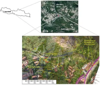
2 Landslide Study Area
2.1 Kalitlaga Landslide
The studied area is in Kalitlaga village which is located in Pagentan District,
Banjar-negara Regency of the Central Java Province of Indonesia (Fig.1). The lithological
composition of the area is characterized by Rambatan Formation which consists of
shale, marl and calcareous sandstone (Condon et al.1996). Specifically, the geological
structure of this area was inclined stratigraphic of sediment layers which consist of
montmorillonite clay covered by colluvial deposits (Karnawati et al.2008).
In view of the imminent landslide hazard in the area, a landslide monitoring system was established in order to assess, track, monitor and record the sequence and failure mechanism of the slope due to intermittent rainfall. The installed field monitoring equipment, as previously discussed, consist of outdoor unit and indoor unit. The outdoor unit, which is made up of strategically positioned sensors and electronic gadgets like long-span extensometers, rain-gauges, internet protocol (IP) cameras and water pressure sensors, records information observed from the field, while the indoor unit processes, stores, and sends real-time information via a GPRS modem which is
displayed on a web-server (Fathani et al.2008). For the further analysis concern, a
reliable data of topography and aerial photo has been reserved through Balloon
Photogrammetry System which combines balloon aerial photography and digital photogrammetry for low-altitude aerial mapping. The balloon carries out a digital camera up to 400 m above the ground level and takes aerial photographs in appropriate viewing angle. The digital photogrammetry processes photo-restitution to produce 3D
model from multi-view aerial photograph (Rokhmana2007).
2.2 Hydrological Influence on Landslide Activity
From hydrological point of view, groundwater is highly affected by rainfall activity and infiltration rate that controlled by land surface condition. Since there is a lot number of cracks and cultivated area comprise the landslide body, the rainfall
can be easily infiltrate into the soil and become groundwater. Angeli et al. (1998)
considered that the rapid piezometric response is attributed to an infiltration pro-cess through a superficial system of interconnected cracks. This system not only works as a fast flow-path from the ground surface to water table, but is also capable to discharge the infiltrated water rapidly.
Fig. 1 Location of Kalitlaga landslide
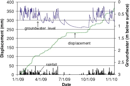
The water pressure sensor attached in an observing well showed that the ground water fluctuation is highly affected by rainfall event. The observation by field monitoring also revealed that there is a high influence of groundwater fluctuation
to soil mass displacement that is recorded in specific area (Fig.2). Based on this
fact, a sound geotechnical model which appropriately predicts the soil mass dis-placement by considering hydrological factor is needed to be developed.
2.3 Hydrological Model
In some studies, hydrological model used for estimating groundwater level
con-siders the geological formation that occurs in particular area. Hong et al. (2005)
have taken the three cascading tank into consideration based on the geological formation that is indicated from the investigation of borehole in Zentoku landslide
on Shikoku Island, Japan. Angeli et al. (1998) also represented the incorporation of
geological structure in hydrological model in the study of Alverà landslide, Italy. The developed model in Alverà consists of two reservoirs that represent the root zone and the clay layer. Each of studies introduced different hydrological model according to particular geological formation in the study area. Developed hydro-logical model in both studies that is previously described needs actual groundwater level data and rainfall data to verify the results.
In this study, required data to support the development of the model are already obtained through pilot project that has been established in Kalitlaga landslide. The general geological condition in the site, such as geomorphology of the area, the lithol-ogy, geological structure and slope stratigraphy has been studied through geological investigation. The specific geological formation in the area arises some consideration of hydrological concept which is can be described schematically with tank model.
The tank model consisted of two series of tank as shown in Fig.3. This model
was based on assumption that the first tank represented the water balance at the surface that was controlled by runoff and infiltration while the second tank rep-resented the colluvium layer. The first tank is used to simulate the surface run-off
0
1/1/09 4/1/09 7/1/09 10/1/09 1/1/10 Date
Fig. 2 The influence of groundwater flow against soil mass displacement
and infiltration into colluvium soil. Once the rainfall enters the first tank, then it is
distributed to the lower outlet D1, in case the previous water level at the first tank
is still below h11. Otherwise, if the water level at the first tank is same as or higher
Fig. 3 Tank model configuration in Kalitlaga landslide
than h11, then the rainfall becomes runoff Q1. The height h11corresponds to soil
moisture capacity. Once the water level at the first tank surpasses h11, one can
interprets that the soil is already saturated and the next rainfall adding up will becomes surface runoff. The second tank represents the input and output of water at the borehole, thus the fluctuation of water level in the second tank corresponds
to groundwater level. The second tank receives discharge from infiltration D1that
subsequently distributed to three outlets of the second tank, which represent the disparity of soil permeability at the borehole.
Land surface and geological condition highly control the infiltration and ground-water fluctuation. Since there is a lot number of cracks and cultivated area comprise the landslide body, the rainfall can be easily infiltrate into the soil and become ground-water. However, groundwater does not exist homogenously under the ground. Groundwater tends to congregate into such a stream due to the diversity of soil
per-meability (Takeuchi1981). The lateral flow from recharge area, which is affected by
existence of cracks, asperity and concave-like shape of landslide base, is assumed to contribute on this phenomenon. Groundwater stream mechanism can be illustrated as ‘‘underground river’’ with some catchments area. However, neither the extent of this area, nor its geohydrological properties are known, and both entities are difficult to
assess (Angeli et al.1998). Although there is no inflow from upper slope that explicitly
represented in tank model, the scale factor (s) is used to represents the inflow from catchments area surrounding the landslide. The scale factor (s) obtained by calibration and one can conclude it as the representation of catchments area broadness. This factor is applied as multiplier factor of total height of the last tank in tank model (H).
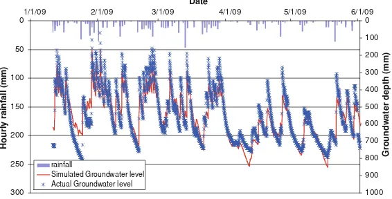
2.4 Result of Hydrological Model
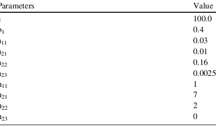
This simulation needs consistent and continuous rainfall data and groundwater level. Thus, rainfall event January 11, 2009–June 19, 2009 which is adequately supported by continuous groundwater level data considered as stored data. The heights, the coeffi-cients and the numbers of outlets at the last tank are determined by trial and error until the simulated groundwater level presents a good corresponding relation with the real Table 1 Parameters of tank
model Parameters Value
groundwater level. This relation can be expressed by the linear regression which results
the simulated levels in boreholes in millimetres. Table1shows adjusted coefficient
values and height of the outlets to satisfy required condition.
The verification used statistical parameter of coefficient of correlation (R) and
volume error (Ve) which are obtained from linear relationship of simulated
ground-water level with the actual groundground-water from field monitoring. The result of simulation
is shown in Fig.4. The red curve that displays the estimated hydrological response to
the rainfall during the chosen intervals proves that the tank model could simulate the groundwater with a good precision. The graphic also shows high response of groundwater level due rainfall activity. The possible reasons of this phenomenon, possibly, are the occurrence of cracks and highly cultivated land which eases infil-tration. The obtained coefficients of correlation confirm the good corresponding
between these two parameters (R=0.927). The volume error (Ve) of simulation result
against the observed data also gives permitted value (Ve=0.042 %\5 %).
2.5 Visco-Plastic Assumption for Slope Kinematics Model
Slow slope movements are typically associated with ‘‘creep’’ behaviour, since the soil can be characterized by a viscous response, implying the presence of a resisting
force that is activated only when the soil mass starts to move (Ranalli et al.2009).
For continuously moving landslides, a dynamic analysis should be adopted
instead a classical static approach (Ranalli et al.2009; Corominas et al.2005). A
classical static analysis is suitable to determine the slope safety factor, but is not able to model the actual kinematics of the soil mass behaviour. In the limit equilibrium stability analysis, the soil shear strength is usually defined by the Mohr–Coulomb criterion, and the instability condition occurs when the equilibrium is modified by a pore water pressure increase and a consequent reduction of the effective stress level. For a given piezometric level, a constant instability force could exist and initiate a
0
1/1/09 2/1/09 3/1/09 4/1/09 5/1/09 6/1/09 Date
Fig. 4 Simulation result of the groundwater level from tank model
slope movement with constant acceleration and a corresponding velocity, linearly increasing with time. When these conditions fail, a possible explanation is the effect of a viscous resisting component of the material. In this case, the mass velocity can be related to the excessive shear stress by different viscous laws, like the Bingham’s law,
which shows a yield point and a subsequent linear relationship (Ranalli et al.2009):
v¼0 s\s0 ð1Þ
v¼ ðz=gÞðssvÞ ss0 ð2Þ
wherevis the velocity (m/s), zis the shear band thickness (m),g is the dynamic
viscosity (N.s.m-2),sis the driving shear stress (N/m2), ands
0(N/m2) is the resisting
shear strength (yield strength). The resisting shear strengths0can be defined by the
Mohr–Coulomb failure criterion at the residual strength state (Van Asch and Van
Genuchten1990). This yield strength line can be described by the following equation:
s0¼c0rþr 0tan/0
r ð3Þ
where: s0=the yield strength; c0r =the residual cohesion; r0 =the effective
normal stress; and/0r =the residual friction angle.
Once the frictional resistance of weight is overcome it starts moving in creep phase with a velocity controlled by the viscous resistance of the dash-pot which is expressed by:
s¼gBv ð4Þ
wheregBcorresponds to viscous characteristic of the soil in the dash-pot andvis
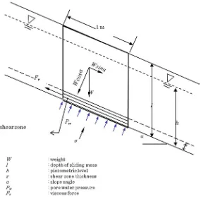
the velocity the sliding block (Angeli et al.1996) (Fig.5) which also represent the
analogy of infinite slope with a viscous deforming layer (Fig.6).
The viscous parameterCis defined as the ratio between the material dynamic
viscositygand the thickness of the shear bandz. The termC=g/z is called as the
coefficient of dynamic viscosity. As a consequence, the contribution to resistance
can be expressed as s=Cm which analogous to the Bingham’s expression for
viscous characteristic of the oil in the dash-pot s=gB m. The Cvalue obtained
from the calibration process (Ranalli et al.2009; Angeli et al.1996).
The dynamics of the landslide are governed by the difference between driving
forces (F), that depend basically on weight and slope, which are constant and
resisting forces (Fr) are sensitive to water pressure at the slip surface (Corominas
et al.2005). The momentum equation can be written as:
FFr¼ma ð5Þ
wheremis the mass (kg) andathe acceleration (m.s-2). Resisting forces can be
estimated using Mohr–Coulomb criterion which considers cohesion and friction parameter. By using infinite slope condition, forces are computed over a unit surface, and therefore shear stresses are considered in what follows;
s½c0þðrpwÞtan/0 ¼ma ð6Þ
wheresis driving shear stress,cis the cohesion,ris the normal stress,pwthe pore
water pressure and/0the friction angle, all magnitude projected to the slip surface.
Figure6is already presents the variables used in this approach.
Corominas et al. (2005) suggested that as the landslide creep movement is
considered as dynamic, thus a viscous term should be included in Eq. (7). That is:
s½c0þðrpwÞtanu0 sv¼ma ð7Þ
Viscous forces are usually dependent on the strain rate of the shear zone. For a Bingham typemodel, this relation is linear and becomes:
sv¼gv=z ð8Þ
where,gis the viscosity,vis the velocity andzis the thickness of the shear zone.
Expression (7) can be introduced in Eq. (9) to give differential equation for a
single point, assumed representative of the whole landslide:
clsinacosac0þ clcos2apwtan/0¼mdv
dtþg v
z ð9Þ
Pore water pressure was not measured directly, but it was estimated from readings of depth of groundwater level. Assuming a parallel flow to the slope surface:
pw¼cwcos 2
ah¼cwcos
2
aðlDwÞ ð10Þ
wherecwis the specific weight of water,lthe thickness of the sliding mass andDw
the depth of groundwater level. Fig. 5 Model of Bingham
body
The governing equation which expressed in Eq. (9) is considered as first order ordinary differential equation. By means of integration, this equation can be solved analytically in terms of velocity by considering the following form:
dy
dxþyPðxÞ ¼QðxÞ ð11Þ
In order to match up the governing equation to general form, the Eq. (9) need to
be modified by dividing both two side with termsm. Hence, the Eq. (9) can be
rewritten as Eq. (12) that is:
dv
dtþB¼A ð
12Þ
where
A¼clsinacosa c
0þ clcos2ap w
ð Þtanu0
½
m ð13Þ
and
Fig. 6 Infinite slope with a viscous deforming layer (z)
B¼ g
zm ð14Þ
Through integration procedure, the Eq. (12) yields the solved governing equation:
v¼A
B 1e
Bt ð15Þ
3 Combined Hydrological and Slope Kinematics Modelling
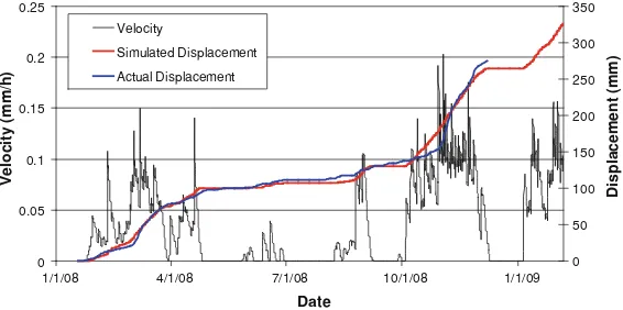
The simulated groundwater level from tank model were used as input to the kine-matics model to directly obtain displacement values as a function of precipitation. The soil parameters that used in kinematic model are obtained from laboratory test of
index properties and CU triaxial test which is shown in Table2. The result of the
displacement simulation of Wire 4–5 and Wire 5–6 for the period January 2009–
January 2010 are shown in Figs.7and8, respectively. The distinctive parameter
between these two simulations is the coefficient of dynamic viscosity (C). This parameter determined through calibrations process until the simulated displacement curve and actual displacement curve are considered to be have a good fit. Wire 5–6 shows the most responsive and highest velocity among the extensometers, thus it is considered to be used for further development of early warning criteria.
Obviously, the use of this model and its parameters are limited to local con-ditions and being a representative for particular area. However, it is believed that this area can be a sort of additional precursor of landslide warning system for the surrounding areas which have more susceptible against landslide prone, i.e. steeper slope and highly populated.
4 Early Warning Criteria
The importance of early warning system arises when other mitigation efforts in avoiding landslide and protecting landslide mass considered being costly and ineffective, meanwhile human lives threatened by landslide disaster anytime.
A good early warning system should give an accurate prediction of landslide occurrences. This kind of ideal early warning system is built by comprehensive understanding of landslide mechanism and supported by representative and accurate data. Thus, the addition of supporting data may increase the accuracy of prediction.
Table 2 Soil parameter Parameter Value
Saturated unit weight,csat(kN/m3) 20.8
Effective internal friction angle,/0(degree) 15.4
Effective cohesion,c0 (kN/m2) 10.4
Formerly, the developed model is able to generate landslide mass creep velocity based on real-time rainfall data obtained from the field. In this particular region of Kalitlaga landslide, where the real-time monitoring implemented, some high precipitation would not emerge a dangerous velocity since the landslide mass just tends to creep. However, in case of other steeper slopes at surrounding area, such kind of precipitation might be disastrous. Hence, it needs to correlate the landslide mass creep velocities in this monitored area with some real landslide event which has happened in vicinity area. Usually, several rainfall data need to be collected in order to support a reliable prediction. However, in this case, the only available data once landslide occurred in Kalitlaga on December 30th 2007 just near the cur-rently studied landslide location is daily rainfall intensity data. However, to develop early warning criteria, the determination of hourly rainfall intensity should be included. Thus, the hourly rainfall distribution is generated based two methods of rainfall distribution; Tadashi Tanimoto method and Alternating Block Method
0
1/1/08 5/1/08 9/1/08 1/1/09 5/1/09 9/1/09 1/1/10
Date
Fig. 7 Simulated velocity, simulated displacement and actual displacement of Wire 4–5
0
1/1/08 4/1/08 7/1/08 10/1/08 1/1/09
Date
Fig. 8 Simulated velocity, simulated displacement and actual displacement of Wire 5–6
(ABM). Tadashi Tanimoto method based on his study about rainfall distribution in Java Islands, whereas ABM method using some formulas in determines the rainfall
duration and distribution (Aras2007).
Subsequently, these rainfall data were stored in previously developed model to generate soil water index (SWI) of each rainfall event. SWI is defined as the total
water level height of the tanks series (Okada2001). In this study, a new proposed
method to built early warning criteria is described by associating the Soil Water Index (SWI) and landslide mass velocity as additional precursor. The determina-tion of SWI from critical rainfall event is achieved initially and its further cor-relation with landslide mass velocity from the combined model taken into account afterward.
The generated SWI from each rainfall scenario is plotted in X–Y graph. The critical line (CL) is then drawn by intersecting two scenarios which is expressed by
lineY ¼ Xþ32. This line is considered as the safest based on available data.
In order to build some additional precursor using landslide mass velocity from particular site, it is needed to divide the velocities into several categories/classes.
The velocities are divided in two classes described in Table3. The velocity range
is categorized using line CL as demarcation line between velocity ranges. The plot of peak velocity is generated from developed combined simulation using recorded
2 years rainfall data from January 18, 2008 to January 18, 2010 is shown in Fig.9.
Fig. 9 SWI and hourly rainfall plots and recorded peak velocities from the model Table 3 Landslide mass
velocity class Velocity class Range (mm/h)
Class 1 (C1) \0.15
Class 2 (C2) [0.15
5 Conclusions
The combined model reliability is strongly depending on data recording validation. The reliable and continuous data leads to high performance of both hydrological model and kinematics model and their combination. Recently, this model is considered as the representative of particular landslide area. However, further study of comparable landslide on similar geological condition with better quan-tification and verification is expected to provide more understanding of landslide movement triggered by rainfall.
The combined hydrological model and kinematics model showed a good agree-ment between computed and actual displaceagree-ment using estimated parameter of tank model. The simulated velocity is possible to be correlated to rainfall parameter generated by hydrological model to develop early warning criteria. The determi-nation of early warning criteria by means of rainfall data analysis and soil water index (SWI) obtained from developed tank model gives a line form of critical line (CL)
Y¼ Xþ32 where x-axis and y-axis corresponds to SWI and hourly rainfall,
respectively. In the mitigation point of view, landslide mass velocities obtained from the combined model result contributed in being additional precursor in early warning criteria by dividing landslide velocity range into two classes.
References
Angeli M, Gasparetto P, Menotti RM, Pasuto A, Silvano S, Uniti CS et al (1996) A visco-plastic model for slope analysis applied to a mudslide in Cortina d’Ampezzo, Italy. Eng Geol 29:233–240
Angeli G, Buma J, Gasparetto P, Pasuto A (1998) A combined hillslope hydrology/stability model for low-gradient clay slopes in the Italian Dolomites. Eng Geol 49:1–13
Aras A (2007) Karakteristik aliran sungai Serayu di bendung gerak Serayu Kabupaten Banyumas, Jawa Tengah. Undergraduate thesis. Civil and environmental engineering department. Gadjah Mada University. Yogyakarta.
Condon WH, Pardyanto L, Ketner KB, Amin TC, Gafoer S, Samodra H (1996) Geological map of the Banjanegara and Pekalongan Sheet, Jawa. Geological Research and Development Centre, Bandung
Corominas J, Moya J, Ledesma A, Lloret A, Gili JA (2005) Prediction of ground displacements and velocities from groundwater level changes at the Vallcebre landslide (Eastern Pyrenees, Spain). Landslides, (Oct 2004), pp 83–96
Fathani TF, Karnawati D, Sassa K, Fukuoka H, Honda K (2008) Landslide monitoring, prediction and early warning in Banjarnegara, Indonesia. Star, 4–6 Sept 2008
Hong Y, Hiura H, Shino K, Sassa K, Suemine A, Fukuoka H et al (2005) The influence of intense rainfall on the activity of large-scale crystalline schist landslides in Shikoku Island Japan. Landslides 2:97–105
Karnawati D, Fathani TF, Sudarno I, Andayani B (2008) Development of community-based landslide early warning system in Indonesia. In: Proceeding of the first world landslide forum, Tokyo, 18–21 Sept 2008, pp 305–308
Okada K, Makihara Y, Shimpo A, Nagata K, Kunitsugu M, Saito K (2001) Soil water index. Tenki 47:36–41
Ranalli M, Gottardi G, Medina-cetina Z, Nadim F (2009) Uncertainty quantification in the calibration of a dynamic viscoplastic model of slow slope movements. Landslides 7(1):31–41 Rokhmana CA (2007) The low cost monitoring system for landslide and volcano with digital
photogrammetry. In: Proceedings of Joint Convention HAGI-IAGI-IATMI, Bali
Takeuchi A (1981) Method of investigating groundwater-vein-streams by measuring one-meter-depth in landslide areas (II). J Jpn Assoc Groundw Hydrol 23(1):1–27
Van Asch T, Van Genuchten P (1990) A comparison between theoretical and measured creep profiles of landslides. Geomorphology 3:45–55