Open Geospatial Consortium Inc.
Date:
2006-01-20
Reference number of this OGC® document:
OGC 05-047r3
Version: 1.0.0
Category:
OpenGIS
®Encoding Specification
Editors:
Martin Kyle, David Burggraf, Sean Forde, Ron Lake
GML in JPEG 2000 for Geographic Imagery (GMLJP2)
Encoding Specification
Copyright © 2006. Open Geospatial Consortium, Inc. All Rights Reserved.
To obtain additional rights of use, visit
http://www.opengeospatial.org/legal
Document type: OpenGIS®
Encoding Specification
Document subtype: (none)Copyright © 2006. Open Geospatial Consortium, Inc. All Rights Reserved.
iii
Contents
Page
1 Scope ...1
2 Conformance ...1
3 Normative
references...1
4
Terms and definitions ...2
5 Conventions...5
5.1 Abbreviated
terms...5
5.2 Document terms and definitions ...6
6
Roles of GML in JPEG 2000 for Geographic Imagery...6
6.1 Introduction ...6
6.2 Coverage
encoding ...6
6.3 Coverage
metadata...7
6.4 Image
annotation...8
6.5 Geographic
features ...8
6.6 Feature and annotation styling ...8
6.7 Coordinate reference systems ...9
6.8 Units
of
measure ...9
7
Encoding rules for GML in JPEG 2000 ...9
7.1 Introduction ...9
7.2 Coverage
description ...10
7.3 Coverage
metadata...11
7.4 schemaLocation
value ...13
7.5 Minimal
instance...14
7.6 Image
annotation...15
7.6.1 Introduction ...15
7.6.2 Annotation entities ...18
7.6.3 Annotation and feature styling ...19
7.7 Coordinate reference systems ...22
7.8 Units
of
measure ...22
8
Packaging GML in JPEG 2000...23
8.1 Introduction ...23
8.2 Single codestream case...23
8.3 Multiple
codestreams
case ...26
8.4 References to XML schemas ...29
8.5 References to XML instances ...30
8.6 URI references within JPEG 2000 files ...30
8.6.1 Introduction ...30
8.6.2 The "xml" resource.type ...30
4
Copyright © 2006. Open Geospatial Consortium, Inc. All Rights Reserved.8.6.4 Relative and absolute forms ...31
B.1 General ...37
B.2 pointOfInterest.xml...37
B.3 curveOfInterest.xml ...39
B.4 regionOfInterest.xml...40
B.5 featureOfInterest.xml...41
B.6 annotation.xml...42
C.1 General ...45
C.2 Example Application Schemas for single code stream ...45
C.2.1 landsat7Coverage.xsd ...45
C.2.2 landsat7Annotation.xsd...48
C.3 Example root instance for single code stream - landsat7Instance.xml...52
C.4 Example Application Schemas for multiple code streams - r3dCoverage.xsd ...56
Copyright © 2006. Open Geospatial Consortium, Inc. All Rights Reserved.
v
Figures Page
Figure 1 — Metadata hierarchy...7
Figure 2 — Annotation entity (point and callout)...18
Figure 3 — Annotation entity (photo callout)...19
Figure 4 — Packaging of GML for a single codestream...24
Figure 5 — Single codestream root instance data in XML Box...25
Figure 6 — Minimal packaging of GML for a single codestream...25
Figure 7 — Packaging of GML for multiple codestreams...26
Figure 8 — Multiple codestreams example root instance data in XML Box...28
Figure 9 — Minimal packaging of GML for multiple codestreams...29
vi
Copyright © 2006. Open Geospatial Consortium, Inc. All Rights Reserved.i.
Preface
This OpenGIS encoding specification defines the means by which the OpenGIS
Geography Markup Language (GML) is to be used within JPEG 2000 images for
geographic imagery. This specification is the result of work in the GML in JPEG 2000
Interoperability Experiment. In 2004, the submitting organizations introduced a candidate
specification document (04-045) which later became an OGC public Discussion Paper
and the basis for conducting the Interoperability Experiment. The Activity Plan for the
GML in JPEG 2000 Interoperability Experiment was formally approved by the Open
Geospatial Consortium in February 2005.
The current revision of this specification has an augmented set of contributors and
submitters than the original Discussion Paper. The additional contributors were a result of
the OGC Interoperability Experiment process and specific written comments that were
generated from various TC meetings as well as a 30 day public comment period.
ii. Submitting organizations
The following organizations submitted the original document or its revisions to the Open
Geospatial Consortium, Inc.
Galdos Systems Inc.
LizardTech, A Celartem Company
European Union Satellite Centre (EUSC)
DM Solutions Group Inc (DMSG)
US Geological Survey (USGS) National Mapping Division
The submitting entities were grateful for the contributions from the following
organizations in the development and revision of this Implementation Specification:
BAE SYSTEMS - Information Systems Sector
Boeing S&IS Mission Systems
Intergraph Corporation
ITT Industries Space Systems Division
PCI Geomatics Inc
SPOT Image (SPOT)
Copyright © 2006. Open Geospatial Consortium, Inc. All Rights Reserved.
vii
iii. Submission contact points
All questions regarding this document should be directed to the editors or the
contributors:
Editors
Name Role Description Company
Ron Lake Executive Editor Responsible for initial draft and specification vision
Galdos Systems
Martin Kyle Managing Editor Responsible for production process and copy flow
Galdos Systems
David Burggraf Contributing Editor Responsible for editing, design and GML content in particular
Galdos Systems
Sean Forde Contributing Editor Responsible for editing, design and JP2 content in particular
LizardTech
Additional contributors
Peter Borrisow (Boeing) Lucio Colaiacomo (EUSC) Michael Gerlek (LizardTech) Didier Giacobbo (SPOT) Trent Hare (USGS) Steven Keens (PCI)
Mitch Kruse (LizardTech) Philippe Merigot (SPOT) Bill Okubo (ITT)
Lucian Plesea (NASA)
John Vincent (Intergraph) in memoriam Frank Warmerdam (DMSG)
Arliss Whiteside (BAE)
iv. Revision history
Date Release Editor Primary clauses modified
Description
25 July 2004
0.0.1 Ron Lake All Initial document, formatted for OGC template
10 August, 2004
0.1.0 David Burggraf
All Added content to clauses in Sections 7 and 8. Reviewed and made minor modifications to all other clauses.
18 May, 2005
0.2.0 Martin Kyle
All Upgrade based on results to date of Interoperability Experiment
19 May, 2005
0.2.1 David Burggraf
viii
Copyright © 2006. Open Geospatial Consortium, Inc. All Rights Reserved. 19 May,2005
0.2.2 Martin Kyle
All Formatting Changes based on OGC endorsed ISO spec format
20 May, 2005
0.2.3 Sean Forde
All Incorporation of gmljp2 URI syntax, updated label names, added comments
23 May, 2005
0.2.4 David Burggraf
7, 8, Annexes A-D Updated sample schemas and instances
23 May, 2005
0.2.5 Martin Kyle
All Final review, clean up, and remaining issues
23 May, 2005
0.2.6 Sean Forde
8.0 Small formatting and syntax changes; modified wording in clause 8.0; removed incorrect abbreviations for JP2 box types; added missing box type labels to box graphics;
23 May, 2005
0.2.7 Sean Forde
3, 6.6, 6.7, 7.5,7.6 Added requirement to comply with OGC document 05-010 for URN references to CRS and UOM when referring to such entities by reference.
23 May, 2005
0.2.8 Martin Kyle
7.6; 8.0 Small abbreviation fixes and grammatical fixes.
21 June, 2005
0.2.9 Sean Forde
3, 7.5,8.2, A.1 Added reference to OGC doc 05-011for CRS definitions; corrected box diagram; added reference to XIMA discussion paper;
22 June 2005
0.2.10 Arliss Whiteside
All Formatting and miscellaneous comments
26 June 2005
0.3.0 Martin Kyle
All Add future work items, merge comments from 0.2.9, proof for RFC
All Updates based on friendly amendments from GML WG at November TC in Bonn, Germany and recommendations for profile
standardization. Prep for R1 vote and release
28 November 2005
1.0.0 Carl Reed All Grammatical and informative edits
29
Annex A, C, D Update location of xlinks.xsd using
authoritative relative reference at OGC schema repository
v.
Changes to the OGC Abstract Specification
Copyright © 2006. Open Geospatial Consortium, Inc. All Rights Reserved.
ix
vi. Future work
Future revisions of this OpenGIS Encoding Specification may:
a) Use other GML coverages including unrectified grid coverages. For example,
before going through an ortho-rectification process, there may be a need to
encode/decode imagery according to the GML in JPEG 2000 standard. The
current revision of this specification only addresses GML rectified grid coverages.
b) Use external references into a GMLJP2/JPX file using a standardized URI
Fragment Identifier Syntax.
c) Accommodate specific needs of netCDF (network Common Data Form) for
scientific data.
d) Address the ongoing work of Observations within the other threads at OGC.
x
Copyright © 2006. Open Geospatial Consortium, Inc. All Rights Reserved.Foreword
This edition cancels and replaces the original draft specification (OGC 04-045) which has
been technically revised.
This document includes four annexes; Annex D is normative, and Annexes A-C are
informative.
The short form of this OpenGIS specification shall be referred to as GMLJP2.
Attention is drawn to the possibility that some of the elements of this document may be
the subject of patent rights. Open Geospatial Consortium Inc. shall not be held
Copyright © 2006. Open Geospatial Consortium, Inc. All Rights Reserved.
xi
Introduction
The OpenGIS Geography Markup Language (GML) standard
(
http://www.opengeospatial.org/standards/gml
)
is an XML grammar for the encoding of
geographic information including geographic features, coverages, observations, topology,
geometry, coordinate reference systems, units of measure, time, and value objects.
The ISO JPEG 2000 standard (
http://www.jpeg.org/jpeg2000
) is a wavelet based
encoding for imagery that provides the ability to include XML data for description of the
image within the JPEG 2000 data file.
This specification defines the means by which GML is to be used within JPEG 2000
images for geographic imagery. This includes the following:
•
Specification of the uses of GML within JPEG 2000 data files.
•
Packaging mechanisms for including GML within JPEG 2000 data files.
Copyright © 2006. Open Geospatial Consortium, Inc. All Rights Reserved.
1
GML in JPEG 2000 for Geographic Imagery (GMLJP2)
Implementation Specification
1 Scope
This specification applies to the encoding and decoding of JPEG 2000 images that contain
GML for use with geographic imagery.
This OGC
®document specifies the use of the Geography Markup Language (GML) within
the XML boxes of the JPEG 2000 data format. The document also establishes the roles of
GML in JPEG 2000 and specifies the encoding and packaging rules for GML use in JPEG
2000.
This OGC
®document is applicable to those interested in using JPEG 2000 as a standardized
geographic image format.
It specifies a minimally required GML definition for georeferencing images and gives
guidelines for augmenting that definition to address the additional encoding of metadata,
features, annotations, styles, coordinate reference systems, and units of measure. This
document treats the case of packaging a single geographic image and the case of packaging
multiple geographic images.
2 Conformance
Conformance with this specification shall be checked using the normative information and
schemas included herein. The framework, concepts, and methodology for testing, and the
criteria to be achieved to claim conformance are specified in ISO 19105: Geographic
information — Conformance and Testing.
3 Normative
references
The following normative documents contain provisions that, through reference in this text,
constitute provisions of this document. For dated references, subsequent amendments to, or
revisions of, any of these publications do not apply. For undated references, the latest edition
of the normative document referred to applies.
IETF RFC 2396, Uniform Resource Identifiers (URI): Generic Syntax (1998)
ISO/IEC 15444-1:2004, JPEG 2000 image coding system: Core coding system
ISO/IEC 15444-2:2004, JPEG 2000 image coding system: Extensions
2
Copyright © 2006. Open Geospatial Consortium, Inc. All Rights Reserved.OGC 03-105r1, Geography Markup Language V3.1.0 (April 2004)
OGC 04-092r4, Geography Markup Language V3.1.1 Schemas (January 2005)
OGC 05-008r1, OWS Common Implementation Specification (January 2005)
OGC 05-010, URNs of Definitions in OGC Namespace (January 2005)
OGC 05-011, Recommended XML/GML 3.1.1 Encoding of Common CRS definitions
XML 1.0 (October 2000), eXtensible Markup Language (XML) 1.0 (2nd edition), World
Wide Web Consortium Recommendation, Bray, T., Paoli, J., Sperberg-McQueen, C.M., and
Maler, E., eds., <http://www.w3.org/TR/2000/REC-xml>
4 Terms
and
definitions
For the purposes of this document, the following terms and definitions apply.
4.1
capabilities
service-level metadata describing the operations and content available at a service instance.
4.2
client
software component that can invoke an operation from a server
4.3
coordinate
one of a sequence of n numbers designating the position of a point in n-dimensional space
[ISO 19111]
NOTE
In a coordinate reference system, the n numbers shall be qualified by units.
4.4
coordinate reference system
coordinate system that is related to an object by a datum
[ISO 19111]
4.5
coordinate system
set of mathematical rules for specifying how coordinates are to be assigned to points
[ISO 19111]
4.6
coverage
feature that acts as a function to return values from its range for any direct position within its
spatiotemporal domain
Copyright © 2006. Open Geospatial Consortium, Inc. All Rights Reserved.
3
4.7
curve
1-dimensional geometric-primitive, representing the continuous image of a line
[ISO 19107]
4.8
datum
parameter or set of parameters that define the position of the origin, the scale, and the
orientation of a coordinate system
[ISO 19111]
NOTE
A datum may be a geodetic datum, a vertical datum, an engineering datum, an
image datum, or a temporal datum.
4.9
domain
well-defined set
[ISO/TS 19103]
NOTE 1
A mathematical function may be defined on this set, i.e. in a function f:A
→
B A
is the domain of function f.
NOTE 2
A domain as in domain of discourse refers to a subject or area of interest.
4.10
feature
abstraction of real world phenomena
[ISO 19101]
NOTE
A feature may occur as a type or an instance. Feature type or feature instance
should be used when only one is meant.
4.11
function
rule that associates each element from a domain (source, or domain of the function) to a
unique element in another domain (target, co-domain, or range)
[ISO 19107]
4.12
grid
network composed of two or more sets of curves in which the members of each set intersect
the members of the other sets in an algorithmic way
[ISO 19123]
4
Copyright © 2006. Open Geospatial Consortium, Inc. All Rights Reserved.4.13
input
data provided to a process.
4.14
interface
named set of operations that characterize the behavior of an entity
[OGC AS 12]
4.15
map
pictorial representation of geographic data
4.16
object
entity with a well defined boundary and identity that encapsulates state and behaviour
[ISO 19107]
NOTE
A GML object is an XML element of a type derived from AbstractGMLType.
4.17
operation
specification of a transformation or query that an object may be called to execute
[OGC AS 12]
4.18
output
result returned by a process
4.19
point
0-dimensional geometric primitive, representing a position
[ISO 19107]
NOTE
The boundary of a point is the empty set.
4.20
process
model or calculation that is made available at a service instance
4.21
range
Copyright © 2006. Open Geospatial Consortium, Inc. All Rights Reserved.
5
4.22
rectified grid
grid for which there is an affine transformation between the grid coordinates and the
coordinates of an external coordinate reference system
[ISO 19123]
4.23
request
invocation of an operation by a client
4.24
response
result of an operation returned from a server to a client
4.25
server
actual implementation of a service
4.26
service
distinct part of the functionality that is provided by an entity through interfaces
[OGC AS 12]
4.27
set
unordered collection of related items (objects or values) with no repetition
[ISO 19107]
5 Conventions
5.1 Abbreviated
terms
EPSG
European Petroleum Survey Group
GML
Geography Markup Language
IETF
Internet Engineering Task Force
JPEG
Joint Photographic Experts Group
OGC
Open Geospatial Consortium
OWS
OGC Web Service
RFC
Request for Comments
URI Uniform
Resource
Identifier
URL
Uniform Resource Locator
6
Copyright © 2006. Open Geospatial Consortium, Inc. All Rights Reserved.5.2
Document terms and definitions
The following specification terms and definitions are used in this document:
a) shall – verb form used to indicate a requirement to be strictly followed to conform to
this specification, from which no deviation is permitted
b) should – verb form used to indicate desirable ability or use, without mentioning or
excluding other possibilities
c) may – verb form used to indicate an action permissible within the limits of this
specification
d) can – verb form used for statements of possibility
e) informative – a part of a document that is provided for explanation, but is not required
f) normative – a part of a standards document that is required
g) annex – an auxiliary part of a document, called an “appendix” in United States
English
h) clause – a major part of a document, called a “section” or “paragraph” in United
States English
i) subclause – a secondary part of a clause or annex, called a “subsection” in United
States English
6
Roles of GML in JPEG 2000 for Geographic Imagery
6.1 Introduction
This clause describes the roles of GML in JPEG 2000 for Geographic Imagery. The
description of these roles provides the context for the supporting mechanisms described in
Clause 7. When encoding information according to one of the types described in this clause
the corresponding encoding mechanism specified in Clause 7 shall be used.
The primary role of GML in relation to JPEG 2000 is to provide an XML encoding of the
metadata necessary to make the JPEG document a georeferenced or geographic image. This is
accomplished by providing, in GML, the description of the image geometry and radiometry.
In addition, GML data can be used, as described in this clause, for the encoding of coverage
metadata, geographic features, annotations, annotation and feature styling, and supporting
components for coordinate reference systems and unit of measure definitions.
6.2 Coverage
encoding
Copyright © 2006. Open Geospatial Consortium, Inc. All Rights Reserved.
7
•
Description of the coverage geometry. In most cases this will be a gml:Grid or
gml:RectifiedGrid, but could be any other GML aggregation geometry type (e.g.
MultiPoint).
•
Description of the value side (or range) of the coverage. This corresponds to the
radiometry in image terms. Note that a GML-JPEG 2000 geographic “image” could
include Digital Elevation Models, Bathymetry data etc. Description of the range of the
coverage may employ units of measure.
•
Description of the mapping of the geometry to the values stored in the JPEG
codestream.
GMLJP2 is intended to handle a variety of imaging use cases including the following:
•
Single geo-referenced images. GML describes the geometry and the radiometry.
•
Multiple geo-referenced images of the same type. GML describes the geometry and
the radiometry of the constituent images. Examples include a stereo photographic pair,
a triangulation block of images, or image mosaics.
•
Multiple geo-referenced images of various types. GML describes the geometry and
the radiometry of the constituent images. Examples include combinations of images
such an optical image, FLIR and SAR images for target identification.
•
Ortho-rectified images with or without associated digital elevation models.
•
Digital Elevation Models that incorporate terrain-based constraints.
Coverage descriptions may require an associated GML application schema. Mechanisms for
referencing and/or transporting GML application schemas are discussed in Clause 8.
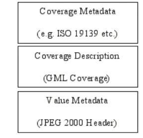
6.3 Coverage
metadata
This clause describes the use of GML to encode metadata about such geographic images. This
approach takes a hierarchical view of metadata as shown in Figure 1.
8
Copyright © 2006. Open Geospatial Consortium, Inc. All Rights Reserved.GML provides a metadata property (gml:metaDataProperty) which can be attached to any
GML object including, of course, a GML coverage. This can either point (via xlink:href) to a
metadata property package expressed via a GML metadata application schema, or enclose a
bundle of such metadata properties in-line. Note that this can be used to support custom,
user-defined metadata schemas or international standards such as ISO 19139. Where ISO 19139 is
used, the coverage information described in GML (GML coverage description) takes
precedence over any geometry or radiometric information provided in the ISO 19139
metadata schema. If such information is provided in the metadata schema it is the
responsibility of the data provider to ensure that it is consistent with the coverage descriptions
provided in GML.
6.4 Image
annotation
A specific GML application schema is provided for expressing annotations (see Clause 7.3
and 9.). Annotations provide an association between geometric “regions” (0d, 1d, 2d etc.) in
an image and annotation text, imagery, video and feature references. Annotations are intended
to be styled for visual presentation. An Annotation can be thought of as drawing attention to
some “region” of an image.
User defined application schemas are not required for image annotation.
6.5 Geographic
features
Geographic features (e.g. features obtained from an image by image interpretation) can be
packaged inside the JPEG 2000 image. Such features may be directly associated with a
particular image in the JPEG 2000 file or may be independent of the image altogether.
Geographic features shall be encoded as GML features and comply with the rules for GML
application schemas as defined in Clause 23 of the GML V3.1.0 Specification (OGC
03-105r1). Encoding of features requires an associated GML application schema. Mechanisms
for referencing and/or transporting GML application schemas are discussed in Clause 8.
6.6
Feature and annotation styling
Geographic features in GML express geographic content. Visual presentation of such
geographic features and annotations requires an external styling mechanism to interpret and
transform the GML features and annotations into graphical objects (e.g. SVG). Styling rules
can be expressed using one of the following:
•
OGC Styled Layer Descriptors (SVG Target)
•
GML Default Styling (SVG Target)
Copyright © 2006. Open Geospatial Consortium, Inc. All Rights Reserved.
9
6.7
Coordinate reference systems
Coverage geometries and the geometric properties of GML features and annotations include
coordinates which are interpreted within the context of a coordinate reference system (CRS).
According to the rules of GML, the coordinate reference system is specified via URI. This
URI may identify the CRS by reference to an authority and an authority maintained code.
Alternatively, these URI may identify the physical location of a CRS definition.
In those cases where an actual CRS definition is required, GML provides a grammar for
encoding such coordinate reference systems. The coordinate reference system definitions
encoded in GML can then be packaged with the JPEG 2000 data (as for features etc.) and
referenced from the coverage description, or features, or can exist externally. This enables
both network-centric and standalone implementations of GML in JPEG 2000 to be deployed.
Some coordinate reference systems may require use of a GML coordinate reference system
application schema. Mechanisms for referencing and/or transporting GML application
schemas are discussed in Clause 8.
6.8 Units
of
measure
Coverage values and properties of GML features and annotations may employ references to
units of measure (UOM). According to the rules of GML, the units are specified via URI. This
URI may identify the UOM by reference to an authority and an authority maintained code.
Alternatively, these URI may identify the physical location of a UOM definition.
In those cases where an actual UOM definition is required, GML provides a grammar for the
encoding of such units of measure. The units of measure definitions encoded in GML can then
be packaged with the JPEG 2000 data (as for features etc.) and referenced from the coverage
description, or features, or can exist externally. This enables both network-centric and
standalone implementations of GML in JPEG 2000 to be deployed.
Some units of measure may require use of a GML units of measure application schema.
Mechanisms for referencing and/or transporting GML application schemas are discussed in
Clause 8.
7
Encoding rules for GML in JPEG 2000
7.1 Introduction
This section describes specific rules that SHALL be followed when encoding GML data for
use within JPEG 2000 files.
All GML instance data associated with a specific codestream is contained in a single GML
feature collection (called the codestream specific feature collection), which contains the
following:
10
Copyright © 2006. Open Geospatial Consortium, Inc. All Rights Reserved.b) GML Features (zero or more).
c) GML annotations (zero or more, see Clause 9.)
These may appear in any order in the codestream specific feature collection (i.e. there is no
requirement that the coverage object be first).
All codestream specific feature collections are feature members of a top-level/root GML
feature collection (see Clauses 8.1, 8.2). The top-level/root feature collection may also contain
as a feature member, a collection of feature instances that are associated to ALL JPEG 2000
codestreams.
GML metadata is referenced through the gml:metaDataProperty which is attached to one or
more of the objects as above.
GML default styles are referenced through the gml:defaultStyle property which is attached to
one or more of the objects as above.
Instance data for units of measure and coordinate reference system definitions may be
optionally provided. This shall be contained in a Dictionary file which SHALL be valid
against the GML dictionary.xsd.
The GML version of instance data can be determined by referencing a retrievable schema
document; the schema documents required to validate an instance shall be retrievable.
7.2 Coverage
description
GML Coverage Descriptions define the associated JPEG 2000 file as a geographic image.
Such coverage descriptions are based directly on the GML coverage.xsd or through the use of
a GML application schema that imports (directly or indirectly) coverage.xsd. There can be
only ONE coverage description instance per codestream, and only ONE coverage description
per codestream specific FeatureCollection. Furthermore, each coverage description SHALL
use gml:RectifiedGrid as its domain. Clause 8.2 provides details on the mapping of coverage
description instances and codestreams in the multiple codestream case.
The following is an example coverage description:
<exp1:AverageTemp dimension="2" gml:id="AT0001">
<gml:rectifiedGridDomain>
<gml:RectifiedGrid dimension="2"> <gml:limits>
<gml:GridEnvelope>
<gml:low>1 1</gml:low> <gml:high>4 4</gml:high> </gml:GridEnvelope>
</gml:limits>
<gml:axisName>x</gml:axisName> <gml:axisName>y</gml:axisName> <gml:origin>
<gml:Point gml:id="P0001"
Copyright © 2006. Open Geospatial Consortium, Inc. All Rights Reserved.
11
<gml:coordinates>1.2 3.4</gml:coordinates>
</gml:Point> </gml:origin>
<gml:offsetVector srsName="gmljp2://xml/crs.gml#crs1123">1
2</gml:offsetVector>
<gml:offsetVector srsName= “gmljp2://xml/crs.gml#crs1123">4
5</gml:offsetVector>
</gml:RectifiedGrid> </gml:rectifiedGridDomain> <gml:rangeSet>
<gml:File>
<gml:rangeParameters>
<exp1:Temperature
uom="gmljp2://xml/uom.gml#degC">template</exp1:Temperature> </gml:rangeParameters>
<gml:fileName>gmljp2://codestream/0</gml:fileName>
<gml:fileStructure>Record Interleaved</gml:fileStructure>
</gml:File> </gml:rangeSet> </exp1:AverageTemp>
This example states that the image is a Temperature coverage on a rectified grid with the
temperature expressed in degrees centigrade.
7.3 Coverage
metadata
Metadata about the GMLJP2 coverage is handled using the gml:metaDataProperty. This
property shall point to (i.e. via xlink:href) or include in-line the various metadata properties
and their values. This will require the use of an external schema to define the metadata
properties. This can be user defined or conform to an international standard such as ISO
19139. An example of such a metadata schema is as follows:
<!-- =========================================================== --> <element name="ImageMetadata" type="app:ImageMetadataType"
substitutionGroup="gml:_MetaData"/>
<!-- =========================================================== --> <complexType name="ImageMetadataType" mixed="true">
<annotation>
<documentation>Landsat7 was launched in 1999. It contains seven
spectral bands andpanchromatic band wide swath width (185 km) with 15-meter, 30-15-meter, 60-15-meter, and 80-meter . It has a 705km sun-synchronous orbit with a 16 day repeat cycle and contains a nadir-pointing instrument (ETM+ sensor).
</documentation> </annotation>
<complexContent mixed="true">
<extension base="gml:AbstractMetaDataType">
<sequence>
<element name="SUN_AZIMUTH" type="gml:MeasureType"
minOccurs="0"/>
<element name="SUN_ELEVATION" type="gml:MeasureType"
minOccurs="0"/>
<element name="QA_PERCENT_MISSING_DATA"
type="gml:MeasureType" minOccurs="0"/>
<element name="CLOUD_COVER" type="gml:MeasureType"
12
Copyright © 2006. Open Geospatial Consortium, Inc. All Rights Reserved.</sequence> </extension> </complexContent> </complexType>
The root GML instance that encodes the corresponding metadata is as shown below:
<Landsat7Coverage dimension="2"> <gml:metaDataProperty>
<ImageMetadata>
<SUN_AZIMUTH uom
="urn:x-IHSDM:v2.05a:uom:angle">114.4699122</SUN_AZIMUTH> <SUN_ELEVATION uom
="urn:x-IHSDM:v2.05a:uom:angle">66.6625502</SUN_ELEVATION> <QA_PERCENT_MISSING_DATA
uom="urn:x-IHSDM:v2.05a:uom:percent">66</QA_PERCENT_MISSING_DATA>
<CLOUD_COVER uom="urn:x-IHSDM:v2.05a:uom:percent">80</CLOUD_COVER> </ImageMetadata>
</gml:metaDataProperty> <gml:rectifiedGridDomain>
<gml:RectifiedGrid dimension="2"
srsName="urn:ogc:def:crs:EPSG:6.6:32612">
<gml:Point gml:id="Pt0001"
srsName="urn:ogc:def:crs:EPSG:6.6:32612">
<gml:pos>270372.375 270372.375</gml:pos> </gml:Point>
</gml:origin>
<gml:offsetVector srsName="urn:ogc:def:crs:EPSG:6.6:32612">1 0</gml:offsetVector>
<gml:offsetVector srsName="urn:ogc:def:crs:EPSG:6.6:32612">0 -1</gml:offsetVector>
<!-- PixelValue11bit=template indicates that the values are not
stored here but elsewhere, ie fileName property-->
</gml:rangeParameters>
<gml:fileName>p037r036_7t20000606_z12_nn10-50.tif</gml:fileName> <gml:fileStructure>Record Interleaved</gml:fileStructure>
<fileDate>2000-06-06</fileDate> <fileFormat>geoTIFF</fileFormat>
<spatialResolution uom="urn:x-si::uom:meter">5</spatialResolution> <spectrum>Multispectral</spectrum>
Copyright © 2006. Open Geospatial Consortium, Inc. All Rights Reserved.
13
<bandRange uom="urn:x-si::uom:micrometer">0.630 0.690</bandRange> <bandRange uom="urn:x-si::uom:micrometer">0.760 0.900</bandRange> <bandRange uom="urn:x-si::uom:micrometer">1.550 1.750</bandRange> </File>
</rangeSet> </Landsat7Coverage>
7.4 schemaLocation
value
When an XML instance is included in an XML Box of a JPX file, the schema location
reference SHALL be encoded as a GMLJP2 URI (see Clause 8).
When using absolute GMLJP2 URI, the header section of this instance file would appear as in
the following example:
<?xml version="1.0" encoding="UTF-8"?>
<gml:FeatureCollection
xmlns:gml="http://www.opengis.net/gml"
xmlns:xlink="http://www.w3.org/1999/xlink"
xmlns:abc="http://www.ukusa.org"
xmlns:xsi="http://www.w3.org/2001/XMLSchema-instance"
xmlns:exp1="http://www.spain.org" xmlns:exp2="http://www.france.org"
xsi:schemaLocation="http://www.ukusa.org gmljp2://xml/myMetadata.xsd
http://www.opengis.net/gml
gmljp2://xml/gmlJP2Profile.xsd
http://www.spain.org gmljp2://xml/coverageSchema.xsd
http://www.france.org gmljp2://xml/featureSchema.xsd"> ….
<gml:FeatureCollection>
When using GMLJP2 URI in its relative form, the header section of this instance file would
appear as:
<?xml version="1.0" encoding="UTF-8"?>
<gml:FeatureCollection
xmlns:gml="http://www.opengis.net/gml"
xmlns:xlink="http://www.w3.org/1999/xlink"
xmlns:abc="http://www.ukusa.org"
xmlns:xsi="http://www.w3.org/2001/XMLSchema-instance"
xmlns:exp1="http://www.spain.org" xmlns:exp2="http://www.france.org"
xsi:schemaLocation="http://www.ukusa.org myMetadata.xsd
http://www.opengis.net/gml gmlJP2Profile.xsd
http://www.spain.org coverageSchema.xsd
http://www.france.org featureSchema.xsd">
…
<gml:FeatureCollection>
Since, in this case, all of the schemas are encoded within the JPEG 2000 file, the decoder
would expect to find schema files in each of the ASSOCIATION boxes with labels
14
Copyright © 2006. Open Geospatial Consortium, Inc. All Rights Reserved.7.5 Minimal
instance
The GML Data shall, at the minimum, consist of a root GML feature collection which
contains as a member, a codestream specific GML feature collection, which in turn contains a
GML Coverage member. This organization of the GML root instance is consistent for both
single and multiple codestream use cases. The simplest RectifiedGridCoverage example given
below does little more than use the coverage domain to geo-rectify the image.
<FeatureCollection
xmlns="http://www.opengis.net/gml"
xmlns:gml="http://www.opengis.net/gml"
xmlns:xsi="http://www.w3.org/2001/XMLSchema-instance"
xsi:schemaLocation="http://www.opengis.net/gml gmlJP2Profile.xsd">
<boundedBy>
<RectifiedGridCoverage dimension="2" gml:id="RGC0001">
<description>This GMLJP2 Minimal Root Instance contains a GML Rectified Grid. The rectified grid is embedded in a
RectifiedGridCoverage with generic range parameters (to be ignored).</description>
<rectifiedGridDomain>
<RectifiedGrid dimension="2"> <limits>
<GridEnvelope> <low>0 0</low>
<high>8718 7812</high> </GridEnvelope>
</limits>
<axisName>x</axisName> <axisName>y</axisName> <origin>
<Point gml:id="Pt001"
srsName="urn:ogc:def:crs:EPSG:6.6:32612">
<description>"Upper-left" image origin</description>
<coordinates>270379.500000, 3942462.000000</coordinates>
</Point> </origin> <offsetVector
srsName="urn:ogc:def:crs:EPSG:6.6:32612">28.5 0</offsetVector>
<offsetVector
Copyright © 2006. Open Geospatial Consortium, Inc. All Rights Reserved.
15
</RectifiedGrid> </rectifiedGridDomain> <rangeSet>
<File>
<rangeParameters> <QuantityList
uom="urn:ogc:def:crs:EPSG:6.6:32612">inapplicable</QuantityList> </rangeParameters>
<fileName>Not Applicable</fileName>
<fileStructure>Record Interleaved</fileStructure> </File>
</rangeSet>
<coverageFunction> <GridFunction>
<sequenceRule order="+x-y">Linear</sequenceRule> <startPoint>0 7812</startPoint>
</GridFunction> </coverageFunction> </RectifiedGridCoverage> </featureMember>
</FeatureCollection> </featureMember>
</FeatureCollection>
Note that the QuantityList value of RangeParameters is set to "inapplicable" and hence the
rangeSet describes its range parameters in only a generic way.
7.6 Image
annotation
7.6.1 Introduction
An annotation is an association between an annotation entity (e.g. a text label—see 7.6.2) and
an image or some geometric “region” within the image. The geometric region is defined by a
GML geometry, which can be a point, linestring etc. If no geometric region is defined the
annotation applies to the entire image (i.e. JPEG 2000 codestream).
An example Annotation with an association to a geometric region has the form:
<Annotation gml:id="AN001"> <pointer>…</pointer> <content>…</content>
<annotates>
<gml:Polygon gml:id="Pl001" srsName="crs.gml#1234"> <gml:exterior>
<gml:LinearRing>
<gml:pos>22 44</gml:pos> <gml:pos>55 77</gml:pos> <gml:pos>88 100</gml:pos> <gml:pos>22 44</gml:pos> </gml:LinearRing>
</gml:exterior> </gml:Polygon>
</annotates>
16
Copyright © 2006. Open Geospatial Consortium, Inc. All Rights Reserved.The pointer property value is a gml:Curve, which is meant to be styled by an arrow or line
symbol and is used to visually represent the annotation association. The content property
value can be either a Label or an Image, which are each annotation entities (c.f. clause 7.4).
The annotates property value is a geometry (Polygon in example above) that represents a
region within the image and is the target of the annotation. Note that the srsName attribute on
the above Polygon specifies the Coordinate Reference System (CRS), which will often be the
Image CRS. The srsName value shown above is in a URI format used to reference resources
located within the JPEG 2000 file (see Clause 8.5). The corresponding schema definition for
the instance fragment above is as follows:
<element name="Annotation" type="xima:AnnotationType"/>
<complexType name="AnnotationType"> <complexContent>
<extension base="xima:AnnotationBaseType"> <sequence>
<element name="pointer" type="gml:CurvePropertyType"
minOccurs="0"
maxOccurs="unbounded"/>
<element ref="xima:content"/>
<element name="annotates" type="gml:GeometryPropertyType"/> </sequence>
</extension> </complexContent> </complexType>
<element name="content"> <complexType>
<sequence>
<element ref="xima:_AnnotationBase" maxOccurs="unbounded"/> </sequence>
</complexType> </element>
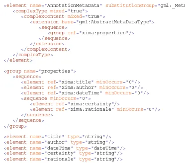
Annotation meta data can be added using the gml:metaDataProperty to describe the author,
data of creation, and certainty (with corresponding rationale for the certainty) of the data. A
PointOfInterest is a specialized type of Annotation that defines a relationship between an
annotation entity and a gml:Point in an image is given as an example.
<PointOfInterest gml:id="POI001">
<gml:metaDataProperty> <AnnotationMetaData>
<title>Some point of interest</title> <author>Author Name</author>
<dateTime>2004-12-12T01:01:01</dateTime> <certainty>medium</certainty>
<rationale>proximity of point is a close match to that of known building</rationale>
</AnnotationMetaData> </gml:metaDataProperty>
<pointer>…</pointer> <content>…</content> <annotates>
Copyright © 2006. Open Geospatial Consortium, Inc. All Rights Reserved.
17
<gml:pos>30 30</gml:pos> </gml:Point>
</annotates> </PointOfInterest>
Note that the rationale property shall occur together with the certainty property or not at all
(which is enforced at the schema level.) The schema fragment for AnnotationMetaData is as
follows:
<element name="AnnotationMetaData" substitutionGroup="gml:_MetaData">
<complexType mixed="true">
<complexContent mixed="true">
<extension base="gml:AbstractMetaDataType">
<sequence>
<group ref="xima:properties"/> </sequence>
</extension> </complexContent> </complexType>
</element>
<group name="properties"> <sequence>
<element ref="xima:title" minOccurs="0"/> <element ref="xima:author" minOccurs="0"/> <element ref="xima:dateTime" minOccurs="0"/> <sequence minOccurs="0">
<element ref="xima:certainty"/>
<element ref="xima:rationale" minOccurs="0"/> </sequence>
</sequence> </group>
<element name="title" type="string"/> <element name="author" type="string"/> <element name="dateTime" type="dateTime"/> <element name="certainty" type="string"/> <element name="rationale" type="string"/>
The specialized types of Annotation defined in annotation.xsd are summarized in the
following table:
Table 1 — Specialized annotations
Element Name
Target of Annotation Association
PointOfInterest gml:Point
CurveOfInterest gml:Curve
RegionOfInterest gml:Polygon
18
Copyright © 2006. Open Geospatial Consortium, Inc. All Rights Reserved.Annotation gml:_Geometry
7.6.2 Annotation
entities
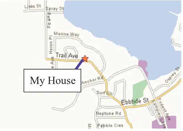
An annotation entity is the source of an annotation association that relates this to a geometric
target within the image. The annotation entities defined in annotation.xsd are Label and
Image, which are derived ultimately from gml:AbstractFeatureType and represent a text label
and another image, respectively. In the figure below a text label “My House” is the annotation
entity.
Figure 2 — Annotation entity (point and callout)
Copyright © 2006. Open Geospatial Consortium, Inc. All Rights Reserved.
19
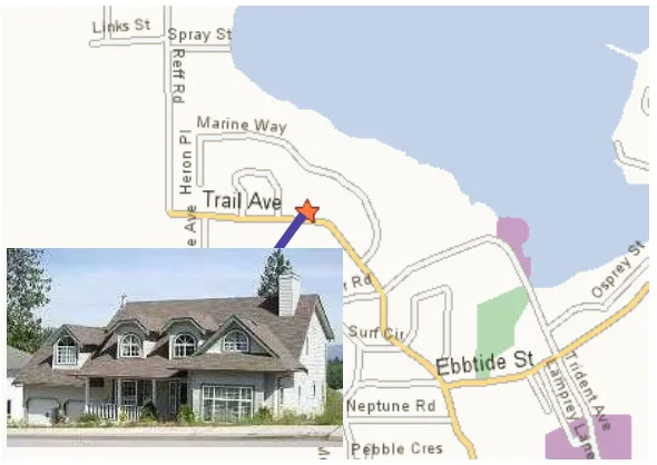
Figure 3 — Annotation entity (photo callout)
7.6.3
Annotation and feature styling
The gml:defaultStyle property can be used to style the corresponding geometry contained
within the pointer, content and annotates properties. Examples of each of these annotation
entities are given in the remainder of this clause.
An example encoding is given for the PointOfInterest annotation using a Label annotation
entity as follows:
<PointOfInterest gml:id="POI001">
<gml:defaultStyle>
<!--Style overlays (blue) line symbol on top of Annotation/pointer
value-->
<gml:Style>
<gml:featureStyle>
<gml:FeatureStyle featureType="PointOfInterest"
queryGrammar="xpath">
<gml:featureConstraint>@gml:id="S5S2S0307301844141"</gml:featureConstrai nt>
<gml:geometryStyle>
<gml:GeometryStyle geometryProperty="pointer"
geometryType="gml:LineString">
<gml:symbol symbolType="svg">
<svg style=" stroke:blue;stroke-width:5"/> </gml:symbol>
<gml:style>stroke:blue;stroke-width:5</gml:style> </gml:GeometryStyle>
</gml:geometryStyle> </gml:FeatureStyle> </gml:featureStyle> </gml:Style>
20
Copyright © 2006. Open Geospatial Consortium, Inc. All Rights Reserved.<!--Style overlays point (star) symbol on annotates property value-->
<gml:Style>
<gml:featureStyle>
<gml:FeatureStyle featureType="PointOfInterest"
queryGrammar="xpath">
<gml:geometryStyle>
<gml:GeometryStyle geometryProperty="annotates"
geometryType="gml:Point">
<gml:symbol symbolType="svg"
xlink:href="http://symbology.com/stars.svg#Star01"/>
<gml:LineString gml:id="L001"> <gml:pos>12 34</gml:pos>
<!--Style creates text label-->
<gml:Style>
<gml:featureStyle>
<gml:FeatureStyle featureType="Label"
queryGrammar="xpath">
<gml:labelStyle> <gml:LabelStyle>
<gml:style>font-family:Verdana;font-size:18</gml:style>
<gml:Point gml:id="Pt001" srsName="crs.gml#1234"> <gml:pos>0 10</gml:pos>
<gml:Point gml:id="Pt001" srsName="crs.gml#1234"> <gml:pos>30 30</gml:pos>
Copyright © 2006. Open Geospatial Consortium, Inc. All Rights Reserved.
21
</PointOfInterest>
In the following example encoding an Image annotation entity is used:
<PointOfInterest gml:id="POI002">
<gml:defaultStyle>
<!--Style overlays (blue) line symbol on top of Annotation/pointer
value-->
<gml:Style>
<gml:featureStyle>
<gml:FeatureStyle featureType="PointOfInterest"
queryGrammar="xpath">
<gml:geometryStyle>
<gml:GeometryStyle geometryProperty="pointer"
geometryType="gml:LineString">
<gml:symbol symbolType="svg">
<svg style=" stroke:blue;stroke-width:5"/> </gml:symbol>
<!--Style overlays point (star) symbol on annotates property value-->
<gml:Style>
<gml:featureStyle>
<gml:FeatureStyle featureType="PointOfInterest"
queryGrammar="xpath">
<gml:geometryStyle>
<gml:GeometryStyle geometryProperty="annotates"
geometryType="gml:Point">
<gml:symbol symbolType="svg"
xlink:href="http://symbology.com/stars.svg#Star01"/>
<gml:LineString gml:id="L001"> <gml:pos>12 34</gml:pos>
<!--Style places image file inside boundary Envelope-->
<gml:Style>
<gml:featureStyle>
<gml:FeatureStyle featureType="Image"
queryGrammar="xpath">
22
Copyright © 2006. Open Geospatial Consortium, Inc. All Rights Reserved.<gml:GeometryStyle geometryProperty="xima:boundary"
geometryType="gml:Envelope">
<gml:style>stroke:maroon;stroke-width:5</gml:style>
</gml:GeometryStyle> </gml:geometryStyle> <gml:geometryStyle>
<gml:GeometryStyle geometryProperty="xima:boundary"
geometryType="gml:Envelope">
<gml:symbol symbolType="other" xlink:href=" file///c/BuildingPhoto.jpg "/>
</gml:GeometryStyle> </gml:geometryStyle> </gml:FeatureStyle> </gml:featureStyle> </gml:Style>
</gml:defaultStyle>
<xima:fileURI>file///c/BuildingPhoto.jpg</xima:fileURI> <xima:boundary>
<gml:Envelope>
<gml:lowerCorner>1 1</gml:lowerCorner> <gml:upperCorner>20 20</gml:upperCorner> </gml:Envelope>
</xima:boundary> </Image>
</content> <annotates>
<gml:Point gml:id="Pt001" srsName="crs.gml#1234"> <gml:pos>30 30</gml:pos>
</gml:Point> </annotates> </PointOfInterest>
7.7
Coordinate reference systems
References to Coordinate Reference Systems (CRS) may take one of the following forms:
•
Reference to an authority and authority maintained code
•
Reference to CRS definition
In those cases where a CRS is identified by reference to an authority and code, it SHALL be
identified by URN as per OGC document 05-010 (URNs of Definitions in OGC Namespace).
CRS definitions may be optionally included as dictionary entries in an XML box (see Clause
8.) within the JPEG 2000 file. These SHALL be encoded in GML as per OGC document
05-011 (Recommended XML/GML 3.1.1 Encoding of Common CRS definitions) and may
depend on additional CRS application schemas.
7.8 Units
of
measure
References to Units of Measure (UOM) may take one of the following forms:
Copyright © 2006. Open Geospatial Consortium, Inc. All Rights Reserved.
23
•
Reference to UOM definition
In those cases where a UOM is identified by reference to an authority and code, it SHALL be
identified by URN as per OGC document 05-010 (URNs of Definitions in OGC Namespace).
Units of Measure definitions may be optionally included as dictionary entries in an XML box
(see Clause 8.) within the JPEG 2000 file. These shall be encoded in GML and may depend
on additional UOM application schemas.
8
Packaging GML in JPEG 2000
8.1 Introduction
This clause describes the mechanisms for packaging GML instance data and GML application
schemas inside JPEG 2000 data files. It also provides rules for encoding references between
GML instances and GML application schemas, and between GML instances. Finally it
provides the rules for associating GML coverage descriptions (see Clause 6.1 and 7.1) and
JPEG 2000 codestreams.
JPEG 2000 Part I defines several box types, including an “xml” box, for storing data
associated with codestreams. JPEG 2000 Part II defines several additional box types,
including a “label” box and an “association” box. This specification makes use of these three
box types in order to store and reference GML data in the JPEG 2000 file.
All GML instance, schema, and dictionary data is stored in XML boxes. In order to allow
references between these XML boxes, each XML box is associated with a label inside of an
association box. This label serves as an identifier by which the XML data can be referenced.
Because JPEG 2000 Part I does not include either the label or association boxes, essential
requirements for addressing XML boxes, all GMLJP2 files SHALL implement the JPX file
format as defined in the JPEG 2000 Part II (ISO/IEC 15444-2:2004, JPEG 2000 image coding
system: Extensions) specification, to the extent required to support those box types.
Additionally it is recommended that GMLJP2 files are written as JP2 compatible by including
the string “jp2” within the compatibility list of the File Type box (see ISO/IEC 15444-1
Annex I).
It is recommended that, according to ISO/IEC JTC 1/SC 29/WG1 N2887; clause 3.2 -
signaling, the presence of GML data in a JPX file should be signaled using the Reader
Requirements box (defined in ISO/IEC 15444-2 Annex M) with a value of 67 meaning that
the file contains GML data based on the OGC standard.
8.2 Single
codestream
case
24
Copyright © 2006. Open Geospatial Consortium, Inc. All Rights Reserved.Figure 4 — Packaging of GML for a single codestream
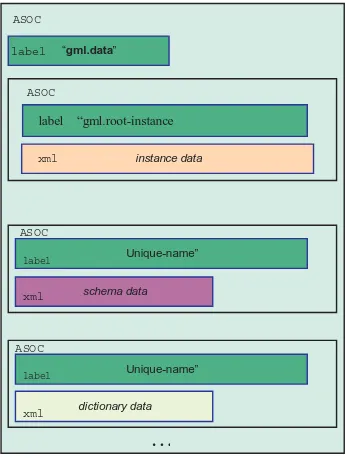
The single “outer” association box contains a box-first which is a label box. This shall contain
the label “gml.data”.
The outer association box shall contain at least one additional association box containing
GML instance data. This association box shall have a box-first that is a label box with the
label gml.root-instance and an XML box. This XML box may only contain GML instance
data for the following items:
•
Coverage description (see Clause 6.1 and 7.1)
•
Metadata instances (see Clause 6.2 and 7.2)
•
Annotation instances (see Clause 6.3 and 7.3)
•
Feature instances (see Clause 6.4 and 7.4)
The box labelled gml.root-instance shall not contain XML schemas and shall not contain CRS
nor units of measure dictionary instances.
Any number of association boxes may follow the gml.root-instance box. Each of the
association boxes, other than the gml.root-instance and gml.data boxes, shall have a label (the
box-first shall be a label box in each case). The value of the label is any value allowed by
JPEG 2000 Part II. This label is used in references to the XML box content using the
mechanism described in Clause 8.5.
asoc “gml.data”
Unique-name” ASOC
…
dictionary datalabel
xml
instance data
xml
label “gml.root-instance
ASOC
Unique-name”
schema data
xml ASOC
label ASOC
Copyright © 2006. Open Geospatial Consortium, Inc. All Rights Reserved.
25
The GML Root Instance data for the single codestream case consists of a root GML feature
collection that contains codestream specific feature collections as members. These nested
GML feature collections are as shown in Figure 5.
<abc:RootFeatureCollection> …
<gml:featureMember>
<abc:SpecificFeatureCollection> …
<gml:featureMember>
<gml:RectifiedGridCoverage> …
</gml:RectifiedGridCoverage> </gml:featureMember>
<gml:featureMember> <gml:FeatureInstance1> …
</gml:FeatureInstance1> </gml:featureMember> <gml:featureMember> <gml:FeatureInstance2> …
</gml:FeatureInstance2> </gml:featureMember> …
</abc:SpecificFeatureCollection> </gml:featureMember>
</abc:RootFeatureCollection>
Image
Metadata
Associated
Features and
Annotation
Figure 5 — Single codestream root instance data in XML Box
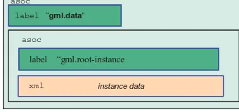
The minimal structure for the Single Codestream (= single image) case is then as shown in
Figure 6.
Figure 6 — Minimal packaging of GML for a single codestream
Note that the instance box SHALL contain the following:
•
GML Coverage Description, whose domain is a gml:RectifiedGrid .
The instance box MAY contain zero or more of the following:
•
Coverage metadata. This SHALL be referenced by the GML metaDataProperty from
the Coverage description.
asoc
“gml.data”
instance data
xml
label “gml.root-instance
asoc asoc
26
Copyright © 2006. Open Geospatial Consortium, Inc. All Rights Reserved.•
Image Annotations (per the GML Annotation Schema described in Appendix A).
Note that the instance box SHALL not contain dictionary definitions for Coordinate
Reference Systems, nor for Units of Measure. If these are to be supplied then an additional
dictionary box shall be provided as in Figure 4.
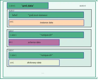
8.3
Multiple codestreams case
The multiple codestream encoding enables multiple image of the same or different type
(different geometry, different radiometry) to be packaged in a single JPEG 2000 file. Stereo
image pairs, triangulation blocks, orthoimagery with associated digital elevation models, and
multi-source image assessment are examples of the use of multiple codestreams.
The structure of the JPEG 2000 file for the multiple codestream case is shown in Figure
Figure 7.
asoc “gml.data”
“<unique-id>”
schema data
xml ASOC
“<unique-id>”
ASOC
… dictionary data
instance data
xml xml
label
label
label “gml.root-instance ASOC
label
xml
Figure 7 — Packaging of GML for multiple codestreams
The single “outer” association box contains a box-first which is a label box. This shall contain
the label gml.data.
The outer association box shall contain at least one additional association box containing the
GML associated to each codestream. This association box shall have a box-first that is a label
box with the label gml.root-instance and an XML box. The gml.root-instance XML box
SHALL contain the following:
•
Coverage description for the associated codestream that uses a gml:RectifiedGrid
domain (see Clause 6.1 and 7.1).
The gml.root-instance XML box MAY contain zero or more the following:
Copyright © 2006. Open Geospatial Consortium, Inc. All Rights Reserved.
27
•
Image Annotations (per the GML Annotation Schema described in Clause 9).
•
Associated geographic features (expressed as GML features)
The box labelled gml.root-instance shall not contain XML schemas and shall not contain CRS
nor units of measure dictionary instances.
Any number of association boxes may follow the gml.root-instance box. Each of the
association boxes, other than the gml.root-instance and gml.data boxes shall have a label (the
box-first shall be a label box in each case). The value of the label is any value allowed by
JPEG 2000 Part II. This label will be used in references to the XML box content using the
mechanism described in Section 8.5.
28
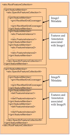
Copyright © 2006. Open Geospatial Consortium, Inc. All Rights Reserved.<abc:RootFeatureCollection> …
<gml:featureMember>
<abc:SpecificFeatureCollection1> …
<gml:featureMember>
<gml:RectifiedGridCoverage> …
</gml:RectifiedGridCoverage> </gml:featureMember>
<gml:featureMember> <abc:FeatureInstance1> …
</abc:FeatureInstance1> </gml:featureMember> <gml:featureMember> <abc:FeatureInstance2> …
</abc:FeatureInstance2> </gml:featureMember> …
</abc:SpecificFeatureCollection1> </gml:featureMember>
…
<gml:featureMember>
<abc:SpecificFeatureCollectionN> …
<gml:featureMember>
<gml:RectifiedGridCoverage> …
</gml:RectifiedGridCoverage> </gml:featureMember>
<gml:featureMember> <def:FeatureInstance1> …
</def:FeatureInstance1> </gml:featureMember> <gml:featureMember> <def:FeatureInstance2> …
</def:FeatureInstance2> </gml:featureMember> …
</abc:SpecificFeatureCollectionN> </gml:featureMember>