1. INTRODUCTORY NOTE
This article deals with the research whose title is “ Survey for a better knowledge of ancient architecture”. The object of study and testing of the different survey methods is the so-called Arch of Drusus located on the Appian Way, near the St Sebastian Gate, ABSTRACT:
The Arch of Drusus is a complex building, stratiied over time. It isn’t possible to advance only one hypothesis about its origin, but its several transformations may be given some interpretations. The dificulty lies in the coexistence of two structures, typologically and
chronologically different, in a single monument: an original structure which can be related to a commemorative travertine arch sheathed in marble, dating back to the Imperial Age, which probably had three fornices and a later structure reused in the III century as an aque-duct arch and monumentalized again with the application of decorated architectural elements on the southern façade. In order to provide a graphic description as much accurate as possible from the metric-dimensional point of view and as much detailed as possible in all the elements which form the building, a new survey methodology has been tested. It uses different kinds of systems – instrumental, topographic and GPS, photogrammetric and direct traditional – which complement each other, in order to render a three-dimensional computerized reference model.
The analysis process of the monument, made from what emerged from the archaeological analysis, thanks to the carrying out of dif-ferent navigable models, has been developed making, in the early stage, a represented model subsequently detailed on the basis of the incongruities detected in the survey.
inside the Aurelian Walls. The research avails itself of the con-tribution of the architectural, survey and archaeological skills of a working group which is part of the Department of Design and Architecture Studies and the Department of Historic-Artistic, Ar-chaeological and Conservation Studies*.
A lot of iconographic evidence remains of this arch, it can be
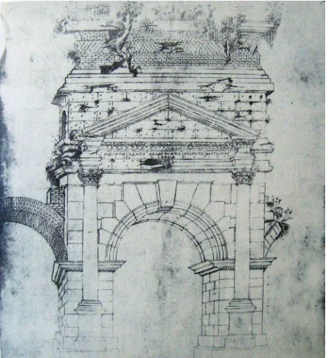
Figure 2. Rome. The Arch of Drusus drawing by Giuliano da Sangallo, 1480 ca. (from Borsi, 1985)
Figure 1. Rome. Appian Gate and the Arch of Drusus. Aerial view
* The research group is composed by: M. Canciani
(coordina-tor), D: Maestri, G. Spadafora, M. D’Emili, D. Manacorda, R.
grouped in three main classes: drawings and engravings of views,
period photographs and architectural surveys, irst of all those
published by De Maria (1980), dated 1933 and those belonging to the Xa Ripartizione A.B.A. of the city of Rome (1983). The comparison among the different drawings has highlighted some
mismatches in the survey: up till now there isn’t, essentially, any
exhaustive study of the arch, which foregrounds its features, de-terioration and cracks; which detects the restoration interventions performed from the XIX century onwards and which highlights the sections of the various mouldings and their precise succes-sion.
2. THE ARCH OF DRUSUS: HISTORICAL CONTEXT
On the Appian Way, just before going out of the Aurelian Walls through the Appia Gate, also called St Sebastian Gate, an arched monument remains (Fig. 1). During the Renaissance it was
iden-tiied with the marble arch of Drusus, a general dead in battle
at the end of the I century BC, whose existence had been hand-ed down by the ancient sources, in particular Suetonius (Suet., Claud., I.3) and the late-antique Regionaries (Valentini –
Zuc-chetti, 1940). Besides the sources also the inding, in the
mid-XV century, of the tomb of the Freedmen of Drusus near the arch probably contributed to the rise of this interpretation (Lan-ciani, 1902). However, the presence of an aqueduct canal which stepped over the arch produced, from the beginning of the XVIII century, a new interpretation, which disproved the previous one assigning the monument the function of fornix of the Antonin-ian aqueduct, a work built by Caracalla to supply his baths (Cat-talini, 1993). Since then, the arch on the Appian Way was named “the so called arch of Drusus” (Lanciani, 1893-1901, Tomassetti, 1910; Lugli, 1925; Rosi, 1933; De Maria, 1988) even if some people continued to consider it the arch of Drusus handed down by the sources (e.g.: Nardini, [1665]; Nibby, 1820; Rossini, 1836; Canina, 1853).
From the end of the XV century the arch became the core inter-est of antiquarians and artists who represented it in engravings,
watercolours and prints (inally: Zocchi, 2009), since it was one
of the rare examples of arched monument still preserved. Thanks to these iconographic sources, come to us in large quantity and
spread over more than ive centuries, a modern history of the
arch has been traced. Towards the end of the XV century it must have appeared to be largely destroyed (Fig. 2); during the XVII century it was probably reinforced with a buttress – as deduced
from the iconographies of subsequent epoch (Fig. 3) – and it was, gradually, enclosed by the perimeter fences of the vines which spread over the sides of the Appian Way (Di Cola, 2011). Throughout the XVIII century until the early decades of the XIX century, so, the arch looked concealed, so that it was considered structurally unitary with the Appia Gate, situated a few metres farther south. Around the 1830s, at the dawn of the great exca-vations on the Appian Way, the structures which overwhelmed the mass of the arch, disturbing the view, were removed (Fig. 4). Luigi Canina, the well-known architect who carried out ex-cavations and restoration works along the Appian Way (Baione, 2011), supervised the insulation works (Di Cola, 2011) purposely undertaken to restore the arch of Drusus to visibility worthy of its reputation. Thanks to this intervention the area where the arch was located assumed the aspect of a square, which we still cross going in or out by the Appia Gate.
Although the evolutionary history of the transformations un-dergone by the arch “of Drusus” has been traced, in its
macro-sequences, the historical problem stays open: deining a possible
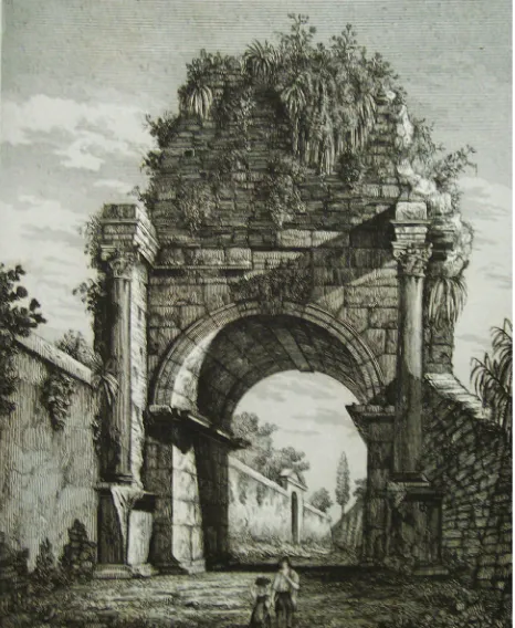
dating of the monument and, if possible, suggesting an interpre-tation. So far, the studies on the arch have lacked a comprehen-sive approach, i.e. that tangle of different source systems which contribute to the construction of a critical set of data (Manacorda, 2008). As a matter of fact, the correlated use of iconographic rep-resentations, integrated survey, structural, stratigraphic and ty-pological analysis has made it possible to multiply the points of view from which the monument can be observed and its historical evolution retraced. At the moment the arch “of Drusus” is seen as a complex ensemble of transformations – occurred not only in modern times but already in ancient times – which can certainly be read, and understood, through an archaeological method. Figure 3. Rome. Northern façade, water colour by Carlo
Labru-zzi. In the mid –XVIII century (from Le Pera – Turchetti, 2003)
Figure 4. Southern façade of Arch of Drusus, partially enclosed
by the perimeter fences of the neighbouring vines. Engraving by
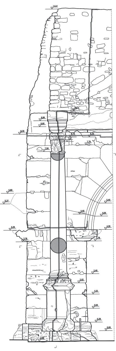
3. MEASURED MODEL, THEORETICAL MODEL AND REPRESENTED MODEL
The tested methodology uses three three-dimensional models, mutually geo-referenced, and closely correlated: a measured model, obtained from measuring made according to the integrat-ed system, a theoretical model, which is the result of the knowl-edge of ancient architecture and a represented model, made in the
inal graphic render.
The measured model, composed of the points derived from the topographic and photogrammetric survey, from directly mea-sured details, is navigable and can be questioned in each phase of the process and it also represents the metric-dimensional
ref-to say from the formalization of models taken from the study of architecture, treatise writing, archaeological, archive,
docu-mentation studies, etc. This model, whose deinition requires the
ultimate contribution of the archaeologists members of the
work-ing group, can’t be considered only one but the sum of several models since the building stratiied over time (Fig. 6).
The theoretical model, built according to the rules of solid mod-elling (extrusion of a section along a path, rotation of a section on an axis, etc.), contributes to determine mismatches between
the hypothetical coniguration of an original element and the real coniguration resulted from the survey, highlighting lacks, addi -tions, changes. In particular, from the analysis of the plinth of the Southern Façade one can notice the combination of elements of
different dimensions, it will make it possible to date that speciic
part of the monument.
The represented model, uses as reference models the measured and theoretical ones, overlapping each other, with particular re-gard to the contribution made by the direct traditional survey and freehand drawing (Fig.7). This choice is dictated by the chosen
representation scale (1:20 ratio), the necessity of iltering the
sometimes redundant data coming from the photogrammetric survey and the belief that this type of graphic representation is the one which can better summarize the main characteristics of
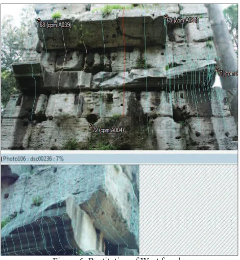
Figure 7. Restitution of West façade: superimpotion of survey model and represented model
Figure 6. Restitution of West façade: superimpotion of theoretical model and survey model
an archaeological monument.
The inal render of the survey is obtained using some compound
graphic drawings (the four main façades and the longitudinal sec-tion) accompanied by horizontal and vertical “in situ” sections
which are made in the most complex points of dificult interpre -tation (Fig. 8). This way the drawings delineate the monument through a represented model which describes the object in its spatial shape and which, studied both as a whole and in detail, makes it possible to analyse each element inserted within the general context.
4. DETAIL DRAWINGS
To supplement data gathered from the photogrammetric model, a direct survey of architectural details has been made thanks to the help of a mechanical arm which has made it possible to reach the highest parts of the monument. The main heights of the
archi-tectural structure and those of the most signiicant elements have
been obtained from the photogrammetric model in order to cor-rectly place, on the drawing, the sections of manually surveyed mouldings.
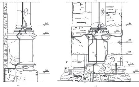
The possibility of making a direct survey of the decorative part of the Southern façade has enabled us to highlight some differences among the constituent elements of the two columns.
Thanks to direct observation, so, it has been possible to ascertain both that the two columns bases have slightly different sections determined by the different depth and height of the single mould-ings, and that the different impost height of the right column compared to the left one (2.28m ca. on the right and 2,39m ca. on the left respectively) is due to the fact that the right column base lacks the upper torus (Fig. 9a).
As a matter of fact, further to some restoration interventions car-ried out in the years 1838-1840, the shaft has been placed on the residual marble fragments of the upper torus, without cincture but simply joining it to the upper scotia with a “cementitious” mixture.
The left column base has been complemented, on the west side, from the axis and for a part which is equal to about a fourth of
the circumference, with a restoration element which continues in part also on the shaft. Mouldings sequence is identical to that of the original base but heights and depths change (Fig. 9b). In the general deterioration state of the arch (Fig. 10), the plinths which support the columns seem to be the most damaged parts from the point of view of materials conservation and architec-tural lines readability (Fig. 11). On the lower moulding of the left plinth two different sections, on the southern front and on the west side respectively, which suggest the hypothesis that the
frontal moulding hasn’t been inished, have been surveyed. Be -sides, both plinths have, on the façade, a protuberance which is very similar to that that can be found on blocks coming from
quarries, doomed to be eliminated in the inishing stage of the
piece. Moreover, it is important to highlight that while on the left plinth it is evident the presence of a drawing with a large bush-hammered surface on all the sides of the dado, the right plinth has a completely smooth surface.
Therefore, the idea is that the arch which is now visible is,
prob-ably actually witness of an uninished coniguration, where dec
-orative spolia elements with different inishing levels have been
reused.
The restoration elements which complete the upper mouldings of both plinths have also been surveyed. Some 50 cm in the right plinth and 60 cm in the left plinth blocks have been introduced during the restoration works of 1838-1840, and link these ele-ments to the structure at the back.
Carrying on in the analysis of the architectural order, measuring directly the two free architraves mouldings it has been possible to verify that the two blocks are almost identical, while capitals, which are both at a 7,56m ca. elevation, have different heights. The left capital seems to be very decayed and placed in an
asym-metrical way on the column to which it isn’t linked (Fig. 12).
According to what has emerged it is evident that direct survey, within the integrated survey sphere, is an essential means of knowledge in the study of any monument, since it provides im-portant puzzle pieces in the reassembling of the complex stratig-raphy of an architectural work.
Figure 8. Photomodeler screenshot: restitution of South façade left plinth, superimpotion of survey model and photo
Figures 9a. Comparison between sections of mouldings of the right column and the left one
Figure 9b. Comparison between sections of ancient and restoration mouldings (left column)
5. THE ARCH “OF DRUSUS”: NEW HYPOTHESES From the archaeological observation of the arch “of Drusus”
emerges clearly that its current architectural structure isn’t the
original one.
The irst datum is the evident posteriority of the aqueduct canal in comparison with the arch. It is proved, irst of all, by the dif
-ferent construction technique of the two monuments: the irst one
is in Opus caementicium with face in Opus latericium, while the second one has the body in travertine Opus quadratum, marble archivolt ashlars and impost cornices and the peperino attic, of which only the impost remains.
Besides, the canal seems to have been built cutting most of the
attic arch, probably to obtain a height which facilitates water low
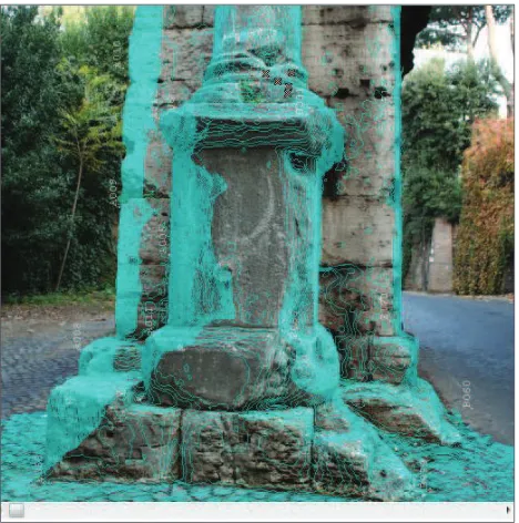
Figure 10. Plinth and base of left column on Southern façade. Front and Western side of survey model
and compatible with the rest of the duct (Garbrecht – Manders-cheid, 1992).
The second datum is the as much evident posteriority of the ap-plied architectural order which decorates the southern façade of the arch, traditionally attributed to Caracalla (Curtis,1908), who, when the moment came to build the Antoninian Aqueduct which headed for his baths, is supposed to have monumentalized the fornix in the passage point on the Appian Way.
The chronological posteriority of decoration is demonstrated by the loss of the covering which, originally, wrapped the travertine
body of the arch, testiied by the holes for the cramps whose func
-tion was to ix slabs. Its absence has made it possible to carve
directly the travertine core, reducing its surface, to facilitate the housing of the architectural elements at the moment of their ap-plication. Therefore, a chronological problem arises because of the loss of the original covering. If the arch covering, now lost, had been marmoreal, one would have some evidence in favour of the hypothesis that it has belonged to Drusus.
An arcus marmoreus was, as previously mentioned, dedicated to the general Drusus. However, the Regionaries written in the IV century cite three arches along the Appian Way, dedicated to Dru-sus, Trajan and Lucius Verus respectively (Valentini – Zucchetti,
1940) and it can’t be ruled out, even if the sources don’t make it
clear, that the other two were also marmoreal.
The third datum is constituted by the offset of the arch “of Dru-sus” rather than the fence of the Aurelian Walls, built in the sec-ond half of the III century (Pisani Sartorio, 1996). The route of
the Appia Way which goes through the arch doesn’t seem to cor -respond either to the way stepped over by the original Appia gate or with the way of the gate subsequently restored by Honorius (Richmond, 1930). It seems, instead, that a rotation towards the south-east of the way occurred. The arch, then, would be a tangi-ble sign of how the ancient Appia Way was before that Aurelian, after several centuries, built its defensive circuit.
There is, inally, the last doubt about the belonging, so far unani -mously shared, of the architectural elements, which decorate the facing south façade, to Caracalla. Although they can stylistically be considered a product of the III century, they could, however, have been used at a later time. As a matter of fact, the stratigraphic analysis has highlighted a posteriority relation between the place-ment of the free architraves – and of the masonry cover which wraps them – and the previous concrete casting of the canal. One could suppose, on the basis of circumstantial evidence, that it occurred during the Renaissance, when ancient monuments were
often embellished or restored (see l’Arco di Portogallo: Torelli,
1993), reusing ancient fragments or taking them elsewhere.
6. CONCLUSIONS
The study on the arch of Drusus in Rome has been organized on the basis of an approach which provides for a comprehensive analysis of the monument from the archaeological point of view, even if it is necessary to be aware of the complexity of the
inter-pretative process applied to a multi-stratiied monument, and a
contextual surveys campaign.
Since the ultimate aim of the survey isn’t solely the dimension -al data acquisition but obtaining elements useful to the over-all knowledge of the monument, one can argue that the tested system allows to study the monument both in detail through direct sur-vey and in the general context through reference spatial models. The operational methodology, related to the survey, arises from data obtained from the archaeological analysis and has been structured on the basis of a sequence of operations which have led to the implementation of a represented model, further detailed
in the inal phase of the work.
The comparison between the outcomes of the study and of the archaeological analysis and the results of the integrated survey and of the use of different models (measured, theoretical and rep-resented), has made it possible to identify those peculiarities and anomalies, in every single element, which have been useful in the process, still in progress, of reconstruction of the building history of the monument.
The architectural typology could render signiicant elements for
the chronological attribution of the arch “of Drusus”. At the
mo-ment we aren’t able to interpret its function(s). It could have been
a commemorative arch, maybe with three fornices, as the project-ing elements on the sides of the central fornix seem to suggest. It could have had an arch-gate function, maybe in relation to the toll wall; or it could have been the fornix of a more ancient aque-duct, then reused by Caracalla for a similar function.
In all three cases the architectural composition of the arch must have provide for a marble slab covering, a decorative group placed on the two main façades – suggested by the typology of the moulded cornices – consisting of free columns or in half col-umns or pilasters, put or obtained from the slabs. It must have had an attic, probably introduced by a moulded cornice, smooth or with a triangular tympanum. The construction technique, its proportions and the peculiarities of the marble archivolt with fan-shaped ashlars suggest that it belonged to the period between the second half of the I century and the middle of the III century.
In the past, some people identiied the arch near the Appia gate
with the arch of Trajan, the second arch cited in the Regionar-ies (Jordan-Hülsen, 1906). In the 1940s, then, some storied slabs fragments came to light near the Appia gate (BCom 1946-1948), attributable to a funerary monument – then also to an arch – dat-able between the second half of the II century and the middle of
the III century (Budde, 1955; Franchi Dell’Orto, 1964), period
to which the arch of Lucius Verus could belong to, the third one cited by the Regionaries. Therefore, the large chronological span where, at the moment, the arch “of Drusus” is included, could comprise all three arches handed down by the Regionaries.
7. REFERENCES
Canciani M., 2007. Sistema informativo geograico come stru
-mento progettuale: il caso di studio del Master Plan della Me
-dina di Costantina (Algeria), in Atti del Convegno E-Arcom 07,
Ancona.
Maestri D., Canciani M., Spadafora G., 2001. Archaeological
Survey: data processing experimentation and direct observation,
in The Cipa International Archives of Cultural Documentation, Volume XVIII, Berlin.
Maestri D., Docci M., 1999. Manuale di rilevamento architet
-tonico. Editori Laterza, Bari 1993, reprint 1999.
Spadafora G., 2006. Dall’archeologia all’architettura. Il rileva
-mento per la comprensione dello spazio costruito. In F.
Coarel-li, F. Pesando, Rileggere Pompei. L’insula 10 della Regio VI, «L’Erma» di Bretschneider, Roma, pp. 370-395.
Baione, C., 2011. Luigi Canina e il primo miglio della via Appia. In: Il primo miglio della via Appia a Roma, a cura di D. Mana-corda e R. Santangeli Valenzani (Atti della Giornata di Studio, Roma-Museo Nazionale Romano, 16 giugno 2009), Roma, pp. 183-192.
BCom, 1946-1948. Notiziario. Regio I, Bullettino della Commis-sione Archeologica Comunale, LXXII, p. 183.
Budde, L., 1955. Severische Relief in Palazzo Sacchetti,Jahr
-buch des Deutschen Archäologischen Instituts. Ergänzungscheft,
18, p. 66.
Borsi, S., 1985. Giuliano da Sangallo. I disegni di architettura e
dell’antico, Roma, pp. 146-147.
Canina, L., 1853. La prima parte della via Appia da Porta Cape
-na a Boville, Roma, I, pp. 51-52; tav. V.
Cattalini, D., 1993. Aqua Marcia. In Lexicon Topographicum Urbis Romae, Roma, I, pp. 67-69.
De Maria, S., 1988. Gli archi onorari di Roma e dell’Italia Ro -mana. Roma, p. 309, n. 91.
Curtis, C.D., 1908. Roman monumental arches, Supplementary Papers of the American School of Classical Studies in Rome, II, pp. 26-83.
mano, 16 giugno 2009), Roma, pp. 193-202.
Franchi Dell’Orto, L., 1964. Ricerche sull’arte di età severiana a Roma, Studi Miscellanei, 4, pp. 35-36.
Garbrecht, G. – Manderscheid, H., 1992. Etiam Fonte Novo Antonini
-ano. L’acquedotto Antoniniano alle Terme di Caracalla, Archeologia
Classica, XLIV, pp. 193-234.
Jordan, H. – Hülsen, Ch., 1906. Topographie der Stadt Rom im Alter
-thum, Berlin, I.3, p. 216.
Lanciani, R., 1902. Storia degli Scavi di Roma. Roma, I, p. 92. Lanciani, R., 1893-1901. Forma Urbis Romae, tav. 46.
Le Pera, S. – Turchetti, R., 2003. Sulla via Appia da Roma a Brindisi.
Le fotograie di Thomas Ashby (1891-1925), Roma, p. 137.
Lugli, G., 1925. La zona archeologica di Roma. Roma, pp. 315-316. Manacorda, D., 2008. Lezioni di archeologia, Roma-Bari, p. 230. Nardini, F., [1665] 1818-18290. Roma antica, Roma, IV ed. di A. Nib-by, I, pp. 155-156.
Nibby, A., 1838. Le mura di Roma, Roma, p. 458.
Piranesi, G.B., 1748. Le Antichità Romane, Roma, I, p. 19, n. 142. Pisani Sartorio, G., 1996. Muri Aureliani. In Lexicon Topographicum Urbis Romae, Roma, III, pp. 290-299.
Richmond, 1930, The city walls of Imperiale Rome, Oxford, pp. 121-142.
Rosi, G., 1933. L’Arco detto di Druso presso Porta S. Sebastiano, Bul-lettino della Commissione Archeologica Comunale, LX, pp. 157-176. Rossini, L., 1836. Gli archi trionfali, onorarii e funebri degli antichi romani, sparsi per tutta Italia, Roma, tav. XXVII.
Tomassetti, G., 1910. La Campagna Romana antica, medioevale e
moderna. Roma, II, pp. 48-50.
Torelli, M., 1993. Arco di Portogallo. In Lexicon Topographicum Urbis Romae, Roma, I, pp. 77-79.
Valentini, R. – Zucchetti, G., 1940. Codice topograico della città di
Roma, Roma, I, p. 91, n. 4; p. 165, n. 10, p. 208, n. 8.
Venuti, R., 1830. Accurata e succinta descrizione topograica delle an
-tichità di Roma, Roma, II, pp. 14-15.