PILOT STUDIES WITH A PHOTOGRAMMETRIC GLACIER LAKE OUTBURST
FLOOD EARLY WARNING SYSTEM
Hans-Gerd Maas
1, Christian Mulsow
1, Anja Wendt
2, Gino Casassa
21
Institute of Photogrammetry and Remote Sensing, Technische Universität Dresden, D-01062 Dresden, Germany
[email protected]
2Centro de Estudios Científicos (CECS), Valdivia, Chile
Commission V, WG V/6
KEYWORDS: Photogrammetric network, image sequence processing, disaster monitoring
ABSTRACT:
Glacier Lake Outburst Floods (GLOFs) depict an environmental risk with an increasing damage potential in many regions of the world. GLOFs are often caused by glacier margin lakes, which suddenly find a drainage path underneath the bottom of a glacier, which is destabilized and retreating as a consequence of local or global climate changes. In a typical GLOF event, a glacier margin lake may drain completely in 24 hours, causing a large flood wave in the area downstream the glacier.
The paper documents some recent GLOF events in the Northern Patagonian Icefield (Chile) and presents a terrestrial photogrammet-ric glacier margin lake monitoring system. The system is based on a camera taking images at regular time intervals. In these images, variations of the water level can be detected by tracking the water-land interface at pre-defined image spots. Due to the drainage mechanism, which is characterized by progressive erosion and melting at the bottom of the glacier, GLOFs are indicated by a pro-gressive water level drop in the lake. Water level changes may be detected with subpixel accuracy by image sequence processing methods. If a 3D model of the lake bottom topography (or at least one height profile through the lake) exists, water level changes in monoscopic image sequences may be transformed into volume loss. The basic idea herein is the intersection of a terrain profile with a water level detected in the image and projected into object space. The camera orientation is determined through a GPS-supported photogrammetric network. Camera orientation changes, which may for instance be induced by wind, can be compensated by track-ing some fiducial marks in the image.
The system has been used in a pilot study at two glacier margin lakes in the Northern Patagonian Icefield. These lakes have a depth of about 80 - 100 meters. The larger one has a length of 5 km and a maximum volume of about 200,000,000 cubic meters. During the pilot study, several GLOF events could be recorded and processed. Water level changes can be determined at decimeter level preci-sion. The results prove the feasibility of the concept, which has to be completed by a data telemetry and alarm system.
1.
INTRODUCTION
GLOFs occur in many regions of the world and are caused by various mechanisms. Regions with a high (or increasing) GLOF potential are for instance the Himalayas, Alaska, Iceland, the Andes and Patagonia. GLOFs often occur by the sudden drai-nage of lakes, which are dammed by glacier tongues or moraines.
With glaciers retreating in most regions of the world, the risk of GLOFs is increasing (Rosenzweig et al., 2007). This is partly caused by the increasing amount of melt water accumulating in glacier margin lakes. A major reason is in the fact that a retreat-ing and thinnretreat-ing glacier tongue will give less detention to the
hydrostatic pressure of the dammed lake water. This process is known as ‘Glen mechanism’ (Glen, 1954; Higgins, 1970): The increasing hydrostatic pressure of a glacier margin lake together with the decreasing detention from a thinning glacier enforces the development of a tunnel at the glacier bottom, through which the lake drains. During the process, this tunnel is wid-ened by melting and erosion, causing a progressive lake drain-age process. Some time after the complete draindrain-age of the lake, the tunnel will collapse, triggered by glacier motion, and the lake will fill again, until it has reached a critical water level. This way, a GLOF cycle is initiated, which may last for weeks, months or years.
The work described in this paper was performed in the Patago-nian Icefield, the third largest continuous icefield in the world (after Antarctica and Greenland), where glaciers are also re-treating (e.g. Rignot et al., 2003; Casassa et al., 2007) and where several strong GLOF events have occurred in the past few years.
An example of such a disastrous event is the GLOF at Lago
Cachet II in the Northern Patagonian Icefield at 6.-7. April
2008 (Casassa et al., 2008). Lago Cachet II is dammed by the
Glaciar Colonia (Figure 1).
Figure 1: Satellite image of Lago Chachet II glacier lake drainage paths (in black) at Glaciar Colonia (Cassasa et al., 2009)
The lake has a length of 5 km, a width of 1 km, a maximum depth of 100 m and a volume of ca. 200.000.000 m3.
For
Glaciar Colonia, a surface decrease of 9.1 km2 (2.7% of the to-tal surface area) has been reported for 1979-2001 (Rivera et al., 2007); Masiokas et al. (2009) report a glacier front retreat by ca. 1 km; Casassa (2009) reports a thinning of the glacier tongue, which is about 2 m/a in the region of the Lago CachetII contact.
In the evening of 8. April 2008, the lake began to drain through a tunnel of 8 km length, which had developed at the glacier bot-tom. The waters flooded the Colonia River valley and flew fur-ther into the Rio Baker, the largest river in Chile, where the wa-ter level rose by 4.5 m within 48 hours and the discharge increased from 1200 m3/s to 3600 m3/s (report Dirección Gen-eral de Aguas, 2008). SevGen-eral similar events were observed in the time since then. Also for the close-by smaller Lago Nef
Norte, which is dammed by Glaciar Nef, several GLOFs were
reported since 2008.
In order to be able to warn (and possibly evacuate) the local residents, plans have been developed to establish an early warn-ing system at critical lakes. Possible techniques are for instance pressure gauges or GPS buoys. Both, however, might be
dam-aged by ice fall or by sudden changes in the geomorphology of the lake basin. As an alternative, the lakes might be observed by terrestrial cameras.
The goal of the work presented here was to perform a pilot study on the use of photogrammetric techniques for glacier margin lake water level change monitoring. This involves the choice and installation of a suitable camera system (section 2), techniques for monitoring water level changes in image se-quences (section 3) and georeferencing techniques (section 4). Results from two pilot studies are shown in section 5.
2.
CAMERA SYSTEM
In two field campaigns in 2009/2010, three cameras were placed at Glaciar Nef and Glaciar Colonia, taking images of
Lago Nef Norte, Lago Cachet II a lake at the front of Glaciar Colonia in regular time intervals. Both field campaigns were
9-day walking expeditions.
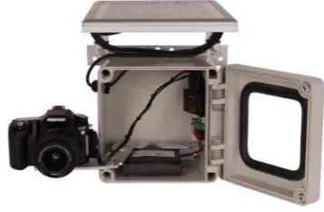
The cameras were Harbortronics time lapse cameras (Figure 2), consisting of an 11 Mpix off-the-shelf SLR camera, a timer, a waterproof body, a solar panel and a buffer battery.
Figure 2: Harbortronics time lapse camera package
The cameras were installed on stable tripods (Figure 3). Some fiducials were installed in the foreground in order to verify the camera orientation stability and to correct for wind-induced ori-entation changes.
Figure 3: Harbortronics camera installation at Lago Nef Norte International Archives of the Photogrammetry, Remote Sensing and Spatial Information Sciences, Volume XXXIX-B5, 2012
3.
IMAGE PROCESSING
The image processing procedure can be divided into the follow-ing processfollow-ing steps (Mulsow et al., 2011):
Camera movement compensation: Camera movements (mainly rotations) may caused by various effects, for in-stance wind effects or human interference. In each image, the coordinates of the fiducials (at least two) were measured by least squares matching, taking the first image of a se-quence as reference. From the fiducial coordinates, an im-age shift was computed and applied to correct for camera movement correction. Image rotations were not significant and thus neglected. In our sequences, image movements of a few pixels (with extremes of up to 42 pixels) could be ob-served.
Water level measurement: So far, automatic procedures for water level measurement turned out to be not sufficiently reliable. Reasons were changing illumination conditions, sediment load in the water, reflections and ice on the water surface. Therefore, the water level was measured interac-tively in this pilot study. A future system will require a reli-able technique for water level measurement in the images, which might also be based on NIR imagery.
Object space transformation: The transformation from monoscopic image space water level measurements into ob-ject space coordinates (and thus water level heights) re-quires knowledge on the exterior and interior orientation of the camera as well as a local scale parameter. As only rela-tive measurements (height changes) are to be determined, several neglect ions can be envisaged. The interior calibra-tion parameters were determined by a pre-calibracalibra-tion of the cameras. The exterior orientation is described in section 4. The local scale parameter is determined from the distance to the water level point at hand, the local surface gradient and the camera constant. For the determination of the dis-tance and the local surface gradient, we need a digital ter-rain model of the lake basis or at least one height profile. Options for this are also discussed in section 4.
4.
GEOREFERENCING
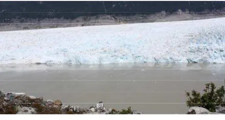
Figure 4 shows a camera image at Lago Cachet II.
Figure 4: Camera image at Lago Cachet II
A multi-image GPS-supported photogrammetric network simi-lar to the one shown by Maas et al. (2010) was established for the determination of the camera orientation parameters. The
network was hampered by some local conditions, especially the inaccessibility of large parts of the glacier surface and the re-gions behind the glacier.
The following information was introduced into the network: Image tie point measurements: At each camera station, a
network of 5-7 images was taken. The base lengths between these images were limited to 100-200 m by local con-straints. In these images, tie points were measured interac-tively. An automatic measurement, for instance in bundler, failed doe to the difficult image contrast situation.
GPS measurements: The coordinates of the camera stations of the network were measured by GPS. Due to load re-strictions on a 9-day walking expedition, only Garmin handheld GPS receivers were available.
Water level constraints: The knowledge on a horizontal wa-ter level was introduced as a constraint into the bundle ad-justment, yielding a number of coplanar points.
Control points: Due to the inaccessibility of the terrain, on-ly very few control points could be determined.
Obviously, these conditions do not allow for a very high preci-sion in the network adjustment and the camera orientation pa-rameter determination. The achievable precision can, however, be considered sufficient due to the fact that only relative height measurements are to be determined. For instance, an error of 20 m at a point 1000 m from the camera leads to a local scale error of 2%, which translates into a 10 cm height change error when the water level drops by 5 m. In future projects, aerial images or high resolution satellite images might also be used to support the camera orientation process.
As discussed in section 3, the image space to object space trans-formation procedure requires the knowledge to the local terrain gradient in vertical image coordinate direction. Several options exist to provide this information:
Airborne laserscanning: For one of the lakes, an airborne laserscanner dataset exists, which was by change taken at a time when the lake was partly drained.
Photogrammetric DTM generation: By chance, Lago Nef
Norte completely drained during our 2010 field campaign.
From that event, a number of amateur camera photos of the empty lake basin exist. So far, attempts to automatically generate a lake basin DTM from these images, for instance by Bundler, failed due to the suboptimal image contrast sit-uation.
Photogrammetric height profile generation: Two of the pho-togrammetric network images for the georeferencing proce-dure as described above were used for the interactive meas-urement of a height profile of the visible part of the lake basin (see principle in figure 5).
Image sequence analysis: In our future work, the image se-quences with the changing water level themselves will be used to determine the lake basin DTM, treating the water level lines (with known height) as contour lines after a rec-tification to the horizontal lake surface.
Figure 5: Lake basin profile for slope determination
5.
RESULTS
In the course of the pilot study, one image sequence at Lago
Nef Norte and one at Lago Cachet II were acquired and
pro-cessed. The results are shown in Figure 6 and Figure 7.
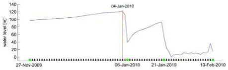
Figure 6: Water level at Lago Nef Norte over a two months period
Figure 7: Water level at Lago Cachet II over a two months period
At Lago Nef Norte, seven images per day were taken in two hour intervals between 4.12.2009 and 8.2.2010. At Lago
Chachet II, a sequence from 27.11.2009 to 10.2.2010 with only
one image per day was available. The sequence at Lago
Chachet II shows two GLOF events within two weeks (but both
not with a complete drainage of the lake), the sequence at Lago
Nef Norte shows one (complete) GLOF. In fact, Lago Nef Norte
drained again at 10.2.2010, just after the end of the sequence.
As mentioned above, both the interactive image space water level measurement and the sub-optimal photogrammetric net-work conditions did not allow for a very high precision. How-ever, while the absolute height precision is in the meter-range, the relative precision (which is relevant for GLOF prediction) can be estimated at a few decimeters.
6.
CONCLUSION
In the pilot studies, the feasibility of a photogrammetric GLOF monitoring system could be shown. Cameras were set up at two glaciers in the Patagonian Icefield, and two image sequences containing three GLOF events were processed.
Future work will mainly address the aspect of reliable automa-tic water level measurement from image sequences as well as a contour-based lake basin DTM generation procedure. Several local constraints in photogrammetric network deteriorate the height accuracy. However, a relative precision of a few decimetres could be achieved. Considering typical GLOF mechanisms, this is sufficient for an early warning system. Exploiting the improvement potential in the georeferencing procedure, a relative water level height determination precision of about one decimetre (or even better) can be predicted.
Obviously, the photogrammetric system is only one part of an early warning system. The system has to be completed by a da-ta telemetry system as well as warning and evacuation schemes. A visual camera based system will not be able to take images at night. However, GLOFs occur usually in summer in regions of larger latitudes, so that one must mostly only anticipate short interruptions of the image sequences of a few hours; this can be tolerated due to the progressive development of typical GLOFs, which can also be seen in Figure 6 and Figure 7.
Acknowledgement:
The pilot studies were conducted in close cooperation between
CECS (Valdivia, Chile) and TU Dresden (Germany). The work
was supported by Fondo Nacional de Desarrollo Científico y
Tecnológico (FONDECYT) and the BMBF International
Bureau. We would also like to express our thanks to Jonathan Leidich and Felipe Henríquez from Patagonia Adventure
Expe-ditions for their support and the excellent organization of the
9-day expedition to the Northern Patagonian Icefield.
References
Casassa, G., Rivera, A., Haeberli, W., Jones, G., Kaser, G., Ribstein, P., Schneider, C., 2007: Current status of Andean glaciers. Global and Planetary Change, Vol. 59, pp. 1-9
Casassa, G., Leidich, J., Rivera, A., Wendt, J., Ordenes, F. ,Escobar, F. ,Guzmán, F., Carrasco, J., López, P., 2008: Sud-den Drainage of Glacial Lake Cachet 2, Patagonia. Fourth EGU Alexander von Humboldt International Conference ‘The Andes: Challenge for Geosciences’. FCFM Universidad de Chile, Santiago, Chile, Nov. 24-28, 2008
Casassa, G., 2009: Recent drainage events of glacial Lake Ca-chet 2, Patagonia. Presentation at the General Assembly of the European Geosciences Union, Vienna
Glen, W., 1954: The stability of ice-dammed lakes and other water-filled holes in glaciers. Journal of Glaciology, Vol. 2, No. 15, pp. 316-18
Higgins, A., 1970: On some ice-dammed lakes in the
Frederikshåb district, south-west Greenland. Meddelelser Fra Dansk Geologisk Forening 19, pp. 378-97
Maas, H.-G., Schneider, D., Schwalbe, E., Casassa, G., Wendt, A. (2010): Photogrammetric techniques for the determination of spatio-temporal velocity fields at Glaciar San Rafael in the Northern Patagonian Icefield. International Archives of
Pho-togrammetry, Remote Sensing and Spatial Information Sci-ences, Vol. 38, Part 5.
Masiokas, M., Rivera, A., Espizua, L., Villalba, R., Delgada, S., Aravena, J., 2009: Glacier fluctuations in extratropical South America during the past 1000 years. Palaeogeography, Palaeoclimatology, Palaeoecology, Vol. 281, pp. 242-268
Mulsow, C., Maas, H.-G., Wendt, A., Casassa, G. (2011): Pho-togrammetrische Überwachung von Gletscherrandseen. Beiträge zur DGPF-Jahrestagung, DGPF Tagungsband 20/2011
Rignot, E., Rivera, A., Casassa, G., 2003: Contribution of the Patagonia icefields of South America to global sea level rise. Science, Vol. 302, pp. 434-437
Rivera, A., Benham, T., Casassa, G., Bamber, J., Dowdeswell, J., 2007: Ice elevation and areal changes of glaciers from the Northern Patagonia Icefield, Chile. Global and Planetary Change Vol. 59, pp. 126-137
Rosenzweig, C., Casassa, G., Karoly, D., Imeson, A., Liu, C., Menzel, A., Rawlins, S., Root, T., Seguin, B., Tryjanowski, P., 2007: Assessment of observed changes and responses in natural and managed systems. Climate Change 2007: Impacts, Adaptation and Vulnerability. Contribution of Working Group II to the Fourth Assessment Report of the Intergov-ernmental Panel on Climate Change (Eds. M. Parry et al.), Cambridge University Press, pp. 79-131