POSE ESTIMATION OF WEB-SHARED LANDSCAPE PICTURES
Timoth´ee Produit1∗
, Devis Tuia1, Vincent Lepetit2, Franc¸ois Golay1
1LaSIG laboratory, Ecole Polytechnique F´ed´erale de Lausanne, 1015 Lausanne, Switzerland 2Institute for Computer Graphics and Vision, Graz University of Technology, 8010 Graz, Austria
Commission III, WG III/1
KEY WORDS:photosharing, landscape images, pose estimation, georeferencing, horizon, DTW, DEM, GIS
ABSTRACT:
We propose a robust method for registering high oblique images of landscapes. Typically, an input image can be registered by matching it against a set of registered images of the same location. While this has been shown to work very well for images of popular urban landmarks, registering landscape images remains a very challenging task: For a given place, only a very small amount of registered im-ages is generally already available on photo-sharing platforms. Moreover, the appearance of landscapes can vary drastically depending on the season and the weather conditions. For these two reasons, matching the input images with registered images in a reliable way remains a challenging task. Our contribution is two-fold: first, we show how to estimate the camera orientation for images with GPS data using a novel algorithm for horizon matching based on Dynamic Time Warping. The proposed algorithm exploits an elevation model. Each image is processed independently from the others, there is therefore no need neither for image matching or for a large set of images. This step provides a set of reliable, fully registered images. Second, and in odrer to register new images with no GPS data available, we first ask the user to provide an approximate image localization on a 2D map. Then, we exploit this prior on the camera location to efficiently and robustly constrain and guide the matching process used to register the query image. We apply our method to a case study from the Zermatt area in Southern Switzerland, and show that the method provides registrations, which are accurate enough to map each pixel to an aerial map.
1 INTRODUCTION
Many recent works have shown that 3D reconstruction of fa-mous monuments or of entire urban areas using tourist photos only is possible (Snavely et al., 2006, Strecha et al., 2010, Agar-wal et al., 2011). Such reconstructions are usually computed in an arbitrary coordinate system and are then georeferenced after-wards, either with Ground Control Points (GCP) or with some reference GIS data, such as a 3D city model or roads vector layers (Strecha et al., 2010). By contrast, much fewer works have considered landscape areas imaged with oblique photogra-phy. This is mainly because in natural landscapes the images are much more sparsely distributed and prone to illumination and seasonal variations (Baboud et al., 2011). With these constraints in mind, applying bundle adjustment becomes difficult, if at all possible (Chippendale et al., 2008). Nonetheless the possibility of exploiting tourist images is very appealing: precisely georefer-enced photo images could become extremely valuable alternative data sources for Earth sciences, which could be used in the esti-mation of the snow melting rate, of the displacements of glaciers, or of land cover changes.
A second motivation is related to web sharing platforms and land-scape image database management. Web sharing applications usually provide 2D maps with pictures location. However, im-ages with associated 3D pose would open new opportunities. First, make 3D navigation between images possible in a virtual globe. Second, a 3D pose is required to augment images with georef-erenced data (rivers, trails, toponyms etc.). Those attributes will also ensure that correct tags are associated to the images for more advanced querying.
This paper aims at providing a semi-automatic 2D-3D registra-tion methodology for landscape pictures issued from the Web: we present an automatic pose estimation workflow for sets of land-scape tourist images. The georeference of each photography is estimated using two data sources: a small set of GPS-registered
∗Corresponding author: [email protected]
images and a Digital Elevation Model (DEM). To estimate the camera orientations for these GPS-located images, we propose an algorithm that matches the horizon silhouette in the images with the DEM. Once oriented, the 3D coordinates of each GPS image is computed. To register a query image, we start from a coarse lo-cation provided by the user by clicking on a 2D map. We use this location as a prior information in a our proposed algorithm that simultaneously estimates the camera pose and establishes SIFT 2D-3D point correspondences between the query image and the GPS-registered images. Finally, the horizon line is further used to fine-tune the camera orientation.
The proposed workflow is applied to a set of pictures of one of the most attractive places in the Swiss Alps: the region of Zer-matt and the Matterhorn. Query images are downloaded from the web-sharing service Panoramio. To assess the accuracy of the resulting orthorectifed images, we compare them with a state-of-the-art orthoimage of the area. This comparison shows an 50 m accuracy on the average pixel localization.
The remainder of the paper is as follows: Section 2 presents re-lated work. Section 3 introduces the pose estimation problem and the ingredients of the proposed workflow, which is detailed in Section 6. Section 7 presents the dataset studied and the ex-perimental results, which are discussed in Section 8. Section 9 concludes the paper.
2 RELATED WORK
Despite all these advantages, georeferencing routines for oblique terrestrial images are less widespread than those dedicated to sets of aerial or satellite images. Among the papers proposing geo-referencing solution for oblique photography, (Corripio, 2004) assess movements of glaciers, while methods in (Bozzini et al., 2011, Produit et al., 2013) georeference historic images. These papers propose tools to compute the pose of an image from user-defined GCP and facilitate the interaction between the oblique image and the map. Once the images have been registered, one can measure objects displacements of augment the image with vector information.
Currently, large efforts are done in the automatic pose estima-tion of images, either at the global or local scale (Li et al., 2012, Crandall et al., 2009, Hays and Efros, 2008, Friedland et al., 2011, or the MediaEval Benchmarking Initiative1). At local scale (and specifically for landscape images), authors showed the po-tential of using GIS data as landmark features or models (see (Ja-cobs et al., 2007, Hammoud et al., 2013, Produit et al., 2014)). A straightforward landmark element in mountainous area is the horizon, which can be easily extracted from a DEM. It has been used in (Baatz et al., 2012a) to recover an image location and ori-entation at the scale of the Switzerland. A DEM provides alos other morphologic edges: authors in (Baboud et al., 2011, Chip-pendale et al., 2008) use this source to orient the images. Finally, the DEM can also be warped with landcover maps (Baatz et al., 2012b) or orthoimages to render more realistic views that can in turn be used as reference for matching query images (Produit et al., 2012). Both these methods allow to avoid explicit matching of the horizon, but the first requires precise knowledge about the camera position and the second is specific to glacier areas with high contrast geomorphological features.
Among the works above, the closest to ours is the one of (Baatz et al., 2012a). The authors build a database of horizon contourlets for the whole territory of Switzerland. This way, they locate 88% of the query images within 1km of their real location. This re-sult is very impressive and promising, but has some drawbacks. First, the method relies only on the horizon, which in the query images can be hidden behind clouds or other foreground objects. Second, the camera orientation is obtained from the horizon sil-houette matched with ICP (Iterative Closest Point): the matching is done in 2D, while the horizon extracted from the DEM has 3D coordinates, which can be used to compute a finer pose. Finally, the horizon segmentation in (Baatz et al., 2012a) requires user intervention for 49% of the images, thus reducing the degree of automation of the system. For all these reasons, we believe that complementary methods still need to be developed.
Landscape images collections differ from urban images mostly used in comparable studies in several ways. First, images density is usually lower in rural area and their overlap is small. Pictures are generally shot from some easily accessible locations and only few pictures can be found in between these popular locations. Second, landscape images show large illumination variations due to daylight changes and seasonal effects. Third, colors, textures and land cover change during the year. For these reasons, tradi-tional bundle adjustment is difficult. Hence, and at the best of our knowledge, there is no workflow able to estimate the pose (location and orientation) of landscape images, if structure-from-motion can’t be applied.
In this paper, we describe a workflow to address these problems and provide the georeferencing of a set of landscape images with limited user interaction. Such a process is well adapted for cur-rent image databases, which often contain only a few precisely located images (GPS acquired) and a wider set of roughly lo-cated ones (toponym or click on a map). In this paper, we focus
1http://www.multimediaeval.org
on landscape images shared on the web. In the workflow pro-posed, the pose of each image is estimated sequentially using the 3D model of the area and some pose priors.
3 PROBLEM SETUP
In this section, we briefly present the basic concepts and equa-tions used in the proposed workflow.
We use the collinearity equations to describe the relation between the 3D world coordinatesX= [Easting, Northing, Height]and the corresponding image coordinatesu. First, a translation and a rotation transform the world coordinatesXin the camera frame with coordinatesx:
x=R(X−T) (1)
whereRis a rotation matrix parameterized by three Euler angles andT = [E0, N0, Z0]is the location of the camera. The camera coordinates frame has two axes parallel to the image sides and the third one is pointing in the viewing direction. Then, image coordinatesuare obtained with:
u=
In this formulation, the image posepis made of the three Euler rotation angles forming the rotation matrixRand the three cam-era location coordinates inT. Thus, 6 parameters are unknown. The constantccorresponds to the focal length:
u=
The pose estimation fromn2D-3D correspondences is defined as a least squares problem:
min
p∈R6
X
kF(ˆp,X)−uk2. (4)
4 DYNAMIC TIME WARPING FOR HORIZON MATCHING
To estimate the camera orientation when its location is available, we match the horizon in the image with the DEM. This is done with a novel algorithm based on Dynamic Time Warping (Berndt and Clifford, 1994), a technique matching sequences of different length based on the warping and distance measurements. Typically, the horizon silhouette is extracted from a rendered view or a synthetic panorama and assuming the camera roll and tilt equal to zero. In this specific setup, DTW shows some desirable properties. First, the warping is used to be robust to image or panorama distortions, inaccurate focal estimation and rendering artifacts.
DTW was originally developed to match two time series with time distortions, acceleration and deceleration, sampled at equal time steps. In our problem of horizon matching, time is replaced by the image coordinates on the horizontal axisu0. The first se-ries is the set ofNquery horizon featureshQ={
u0, ...,uN}and
the second is composed ofM reference horizon featureshR =
{u0, ...,uM}, both ordered by increasing horizontal coordinate.
DTW computes a set of correspondence pairsCi∈[0,N],j∈[0,M]= {...,(i, j), ...}, which minimizes the global performance measure between the matchedhQ
andhR
. The global performance is the sum of the Euclidean distances measured between corresponding features inC. Moreover, each horizon feature in the reference image is linked to a 3D coordinateHR={
X0, ...,XM}.
translation to the GPS data and optimizing the rotation only. It-erations are stopped once the orientation is stable or after a pre-defined number of iterations. In this way, the global measure is used to detect the best azimuth and 2D-3D correspondences are used in an iterative way to retrieve accurately the azimuth, roll and tilt and thus ensure that each pixel will be accurately georef-erenced.
5 FULL POSE ESTIMATION VIA KALMAN FILTERING
If a posepand its varianceΣpare known, variance propagation is
used to estimate the covariance ellipses of a 3D correspondence Xiprojected in the image frame :
Σui =AiΣpATi (5)
whereAiis the jacobian ofF(p,Xi). In our implementation,J
sets of 2D-3D correspondences are found iteratively. The prob-lem can be reformulated in the following form to be used in a Kalman filter:
min
p∈R
J
X
j=1
kAj(p,Xj)−ujk2 (6)
Following the Kalman filter algorithm, if a posepjis associated
with a covariance matrixΣpjand the noise covariance of the
mea-surement isΣu
j. Then the gainKjis:
Kj= ΣpjA T j(AjΣpjA
T j + Σ
u j)
−1
(7)
The gain is then used to update the pose:
pj+1=pj+Kj(uj−Ajpj) (8)
And to update the pose covariance:
Σp
j+1= (I−KjAj)Σpj (9)
In the proposed workflow, a recursive pose estimation process is needed to refine the 2D-3D correspondences extraction for each estimation of an image pose. The Kalman filter has the advan-tages of using prior information and of keeping a memory of the process, which limits the influence of false positives. Moreover, it is able to deal with several types of measurements, for example an update of the camera height with the DEM. However, since in this case study our focus is the minimization of the reprojection error and not the exact camera location computation, we did not include the height update.
6 PROPOSED WORKFLOW
In the previous section, we defined the tools required for the pose estimation of landscape images. In this section, we first explain how images having known location (e.g. acquired with a GPS-enabled camera) are oriented. Then, we present how these images are used as references for the pose estimation of the remaining images in the database.
6.1 Orientation of the GPS images using the horizon
A small part of images found in photosharing platforms are ge-olocated with a GPS device. GPS mounted on cameras and cell-phones have a sufficient accuracy for our purposes (<20m). In particular, our study area is open and above the forests limit, thus no obstructions should disturb the GPS measurements. For this small set of images, we assume that the camera locationT is known, while the orientation is unknown. It has been shown that
DEM
GPS image
T
Horizon
(Watershed) Horizon 2D Horizon
(Rendering) Horizon 3D
Orientation DTW
GPS Image
T, R
Rendering
GPS image
T, R, 3D
Figure 1: Processing of the GPS images,Trefers to the camera location measured with the GPS,Ris the orientation of the cam-era. At the end of this step, each GPS-image pixel owns a 3D coordinate.
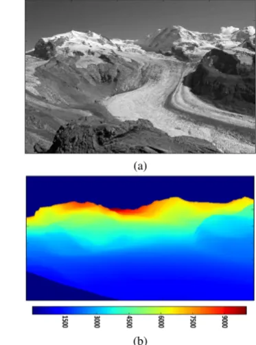
(a)
(b)
Figure 2: (a) One of the reference GPS images; (b) Correspond-ing distance matrix: each pixel is coloured as a function of its distance to the camera (in meters).
the camera orientation in mountainous area can be automatically retrieved (e.g. (Baboud et al., 2011)). Nevertheless, as in (Baatz et al., 2012a) we choose to involve the user in the extraction of the horizon in order to ensure an accurate delineation and at the same time avoid heavy pose computation. We propose to ex-tract it using a watershed segmentation, where the user provides an initialization region. Indeed, a precise horizon delineation is essential for a precise camera orientation: the user involvement ensures a trustable horizon detection, especially in cloudy images and ensures that those images used as reference later are well ori-ented.
Following the process presented previously for DTW horizon match-ing, 2D-3D correspondences in the horizon are used to compute the image orientation. Ultimately, 3D coordinates of each one of the GPS image pixels are computed by projecting the DEM in the image plane via thez-buffer method. Figure 1 summarizes the workflow applied to get the orientation of the GPS images, while Figure 2 illustrates an example of 3D coordinates of an oriented image obtained with the proposed method.
6.2 Pose estimation of the remaining images
GPS-imageS
Figure 3: Processing of the query images,T0refers to the geotag, Ris the orientation of the camera.
prior are known and 2D-3D correspondences are detected solely based on the geometric location of features. In our case the prior is the geotag and orientation extracted from reference images. We add feature descriptions to the process, since they are also available. The involvement of the 3D coordinates of the features detected in the reference images has two effects: on the one hand, 3D coordinates are used to restrict possible matches and to adapt the SIFT matching threshold, while, on the other hand, 3D coor-dinates in a global coorcoor-dinates system allows to take advantage of small overlaps in non-densely photographed areas.
The workflow of this second phase is summarized in Figure 3. In the first part, the geometric constraint requires an estimation of the camera locationT0(which is obtained with the geotag) and an estimation of the orientationR0. To compute the latter, SIFT features are extracted from the collection of reference GPS im-ages. Features from every reference image are merged into one set ofnfeaturesRiwith corresponding 3D coordinatesXRi and
SIFT descriptionsdRi. Given a query image, a set ofmfeatures
Qiare computed and each of them has an image locationuQi and
a descriptiondQi . SIFT features are firstly matched according to the ratio of the two closest features descriptions found in the other set (Nearest Neighbour Distance Ratio, NNDR). Using the NNDR, a set of 2D-3D correspondences is extracted. Those first matches are used to compute the initial camera orientation with RANSAC in conjunction with the camera orientation model (the camera is initially fixed at the geotag locationT0, figure 4(a). Typically, few and poorly distributed matches are found, and this is why we do not use RANSAC in association with the pose es-timation model. The posepQ0 is associated with a high standard deviationΣp
0and the matches are associated with noiseΣ
u
0. During the second part, corresponding to the geometric match-ing, the reference featuresXRi are projected in the query image:
uRi = f(pQ,XRi ) and the variance propagation in Eq. (5) is
used to compute the corresponding covariance matrixΣR u. Based
on the covariances, ellipses are drawn in the query images and used to constrain the SIFT feature matching, as illustrated in Fig-ure 4(b-c). The Kalman filter prerequisites are met and with each new bloc of 2D-3D correspondences, a new pose is computed. During the iterations, the SIFT distance threshold between two features descriptions is relaxed to take into account texture and illumination variations.
At this stage, the estimated pose is quite accurate, but the align-ment with the 3D model is still not exact because of the pose inaccuracy of some reference images and of accumulated errors.
We propose to update the pose with an additional horizon align-ment. This time, the current pose and its covariance are used to delineate the region in the query image where the horizon should be located. Then, a Sobel edge extractor is applied inside this re-gion and the DTW algorithm is used to refine the orientation, as shown in Figure 4(d).
At the end of the process, the query image is draped on the DEM to generate an orthorectified image that can be used in a GIS (Fig-ure 4(f)).
7 RESULTS
In this section, we apply the proposed workflow to a real collec-tion of landscape images shared on the web. Particularly, with limited user interaction, our method can be used to compute the pose of the oblique image and orthrectify it.
7.1 Data
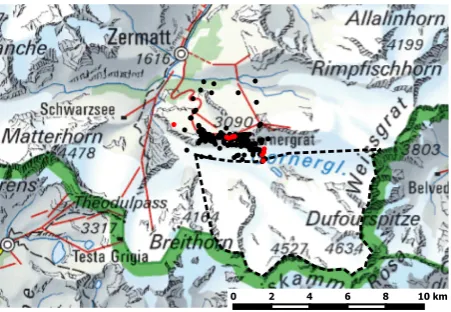
The area of interest is located in the southern Swiss Alps in the surroundings of the famous Zermatt ski resort. From Zermatt, a train brings people to theGornergrat, a ski and hiking region in the middle of the highest Alps peaks. From this area, there is a great view on theMatterhornand theDufourspitze, which are among the most famous Swiss peaks. A large amount of pictures is shot in the area representing one of those two peaks. Figure 5 shows the area and the location of the images available.
0 2 4 6 8 10 km
Figure 5: Zermatt area. The red dots represent the GPS images location, while black dots are the images with geotags only. The dashed line encloses the area of interest. Most of the images are shot from the Gornergrat ridge.
A set of images is extracted from the photosharing platform Pano-ramio. This platform is mainly dedicated to”Photos of the world”
and thus oriented to landscape scenery. Once they connect to this platform, users can assign a map location to the pictures by the GPS record, a click on a map or by entering an image location. Especially because of this last technique, some geotags are very inaccurate. For instance, in the map of Figure 5, some inaccurate geotags are those located on the very North.
In order to compute the camera pose correctly, the focal length must be estimated. A good estimate can be computed from the focal which is stored in the image metadata and from the camera sensor size, which is found in online camera databases. If the image metadata is incomplete, a normal lens is assumed (focal length equal to the diagonal of the image). In total, our set of images pointing to the area of interest is composed of 198 images, among which 10 have a GPS location and 118 have the focal stored in the metadata.
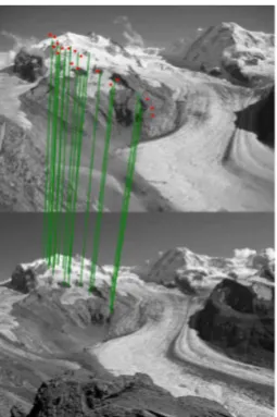
(a) Initial matches found after the NNDR matching and
RANSAC orientation. (b) Covariance ellipses at the first iteration.
(c) Covariance ellipses after 10 iterations. (d) Horizon projected in the image before (red) and after (green) DTW matching.
(e) Query picture masked with DEM and the SIFT features (only the area within the convex hull of the
matched SIFT is conserved).
(f) Query picture orthorectified.
Figure 4: Representation of the query images pose estimation workflow.
Topography2, which has a 25m pixel size. Indeed, our focus is on objects far from the camera (beyond 1km), which makes the use of a finer DEM unnecessary. Some height inaccuracies are expected in glacier areas, since glaciers move and melt.
7.2 Reference GPS image orientation
To validate the success of the proposed workflow, we first mea-sure the accuracy of the pixel localization. Indeed, our method minimizes the reprojection error, but because of distortions not taken into account explicitly (focal, principal point location, im-age distortion) and false positive matches, the estimated pose may differ from the real one, while still providing good pixel localiza-tion close to the correspondences. To measure the accuracy of the pixel localization, we applied the following scheme: the images are orthorectified with the DEM (i.e. according to the pose each
2http://www.swisstopo.admin.ch/
pixel is projected on a triangulation of the DEM to retrieve its corresponding map coordinates), thus resulting in orthorectified images. Then, distances are measured between similar landmarks found on the rectified images and on an official orthoimage (accu-racy<1m). For each image, between 5 and 15 planar distances are measured and statistics are presented in Table 1. Two orien-tation methods are compared: horizon matching with DTW and user defined GCP. The GCP digitization accuracy depends on the resolution of the oblique image. To provide a fair comparison, we used images with 500 pixel width for both methods.
First, we comment the user interaction required for both methods. It is much easier for an user to provide the initialization region of the horizon than to detect precise GCP. Indeed, and specifically for this study case, it is not obvious to find similar rocks or cracks in oblique images and orthoimages.
Table 1: Distances measured between recognizable landmarks found both in an orthoimage and in rectifiedreference GPS im-ages. Reference images were oriented either with DTW (left) or GCP (right) and they are presented in Figure 6.
DTW/GCP
Table 2: Distances measured between recognisable landmarks found on an orthoimage and onrectified query images. Those images are also those presented in Figure 6.
Picture ID Min. dist. [m] Max. dist. [m] Av. dist. [m]
no sensible difference in the accuracy of the methods. On the average, the accuracy of the pixel localization is better than 50m, which is good according to the image resolution and the geometry of the problem (Kraus, 2007). Indeed, and unlike vertical images, the angle between pixel rays and the DEM in oblique images is usually large. In particular, the ray is almost tangent in flat areas and close to the horizon. In these regions of the pictures, small inaccuracy of the pose generates large distortions. The worst ac-curacy observed, for both DTW and GCP, is measured for the same image (24694380), which may indicate that either the GPS location or the focal estimation is incorrect. Images presented in Table 1 have easily extractable horizon (sky without clouds): the performances tend to decrease when clouds occlude the horizon.
7.3 Query image pose estimation
Once the pose and the 3D coordinates have been estimated for all the GPS images, we can use them as references for the re-maining query images. A pose is computed for the query images, for which RANSAC can found initial matches (100 images over the 188 query images). However, some poses are clearly incor-rect (10 images): these incorincor-rect poses are associated to images, for which RANSAC returns only false positives. At the end of the pose estimation process, inexact poses are also computed for images with few correspondences irregularly distributed in the image. These poorly distributed correspondences generate large uncertainty in the areas without correspondences. However, by erasing image areas without correspondences, we somehow avoid very large distortions. Finally, the horizon matching step applied to refine the pose is useful for images without clouds, but may suffer of undesirable effects in presence of clouds (see the dis-cussion in the previous section). Statistics for 7 query images are presented in Table 2. As expected the accuracy decrease com-pared to the reference images. The geometry effects presented above generate even larger distortions in some regions of the im-age close to silhouette break lines.
To assess the accuracy of the pose itself, we computed as refer-ence the orientation of one image with GCP (the image is pre-sented in Figure 6). Then, we started the pose estimation using a geotag randomly located on circle centered on the location es-timated with GCP and with increasing radius. For each distance, 10 pose estimations are conducted. The mean and standard de-viation of the absolute difference between the computed param-eters and the one obtained with GCP are presented in Table 3.
Table 3: Impact of the geotag on the pose accuracy. For a same image, the initialisation location is generated at different distances. Distances are measured in meters, angles in degrees.
Mean Dist. ∆XY ∆Z ∆head. ∆tilt ∆roll
3000 2992.3 (0) 367.5 21.9 7.4 2.4 Std. dev. Dist. ∆XY ∆Z ∆head. ∆tilt ∆roll
2000 280.1 189.3 2.8 2.4 0.4
3000 1877.1 540.9 13.5 7.8 0.4
Between parenthesis, we summed the number of pose locations within a 100m radius of the reference location. It appears, that most of the poses in a 500m radius reach a local minima. We can see it also from the small standard deviations in∆XY. This minima is not centered on the real location but 100m away, this shift can be explained by the registration errors of the reference images and some false positives detected. Beyond this thresh-old, for distances from 500m to 2km, the variance increases, and some poses do not converge to the minima. Beyond 2km, com-puted poses hardly converge.
A video is available on the following link3. In this video, the 100 images for which the pose was estimated are rendered on a shaded 3D model of the area, including those with poor match-ing. Holes in the reconstructed surface correspond to regions of the map which are hidden from the camera position. Quite of-ten, patches of sky are visible at the proximity of the horizon; this illustrates the misregistration problem due to tangential ge-ometry. Attentive viewers will also notice foregrounds projected on the background (a man with a hat, a bird on a fence, a lake). However at the scale represented in this video, the registration is usually of good quality and at least represents a great improve-ment compared to an unique geotag.
8 DISCUSSION
The proposed workflow is composed of four stages: For the first stage (orientation of the GPS images), we propose a DTW-based horizon matching. The area studied in this application is indeed perfect for horizon matching thanks to the mountains that pro-vide specific silhouettes. However, in presence of other kinds of silhouettes (flatter or with repetitive shapes) or in presence of foreground objects perturbing the horizon (trees, buildings) DTW may fail. In this case, the user can constrain the matching with an azimuth range or provide some GCP. In term of time spent and skills, less than 20 seconds are required to provide a very good watershed initialization, while the digitization of GCP will require a skilled operator, a GIS and for each GCP at least the same amount of time as the one spent for the sky segmentation. Currently, the segmentation is led by the user and automatic sky segmentation (if robust enough) would be a great improvement (see a recent review in (Boroujeni et al., 2012)).
Our workflow is strongly dependent on thea prioriorientation, which gives a lot of emphasis to SIFT. This step supposes that im-ages, which are similar (season, illumination) to the query images
are present in the reference database. At this stage, more than 50% of the images were correctly georeferenced. We could also increase this percentage by running a second pass of the process (using not only GPS images as reference, but also the newly geo-referenced ones). To overcome the use of SIFT, rendered views could also be used as reference images, but the challenge then becomes to find a set of descriptors able to match synthetic and real images (see (Produit et al., 2012)).
The location part of thea prioriorientation is based on the geo-tag provided by the user. Some web applications store the zoom level applied on the map by the user when clicking as a mea-sure of the localization accuracy. However, the relation between the zoom and the accuracy is not straightforward and here we as-sumed for every geotag a standard deviation of 1000m. (Zielstra and Hochmair, 2013) studied image geotag accuracies for several type of landscapes and several areas of the world. We can learn from this paper that in natural landscape users provide location much better than that.
In general, the accuracy around detected correspondences is co-herent to ana prioriexpected accuracy (<50m). For this case study, we used low resolution images, and improvement may still be observable by considering full resolution images. Accuracy tends to decrease in image regions where no or false correspon-dences are found (for instance close to the image borders) and in sinuous parts of the DEM, which generate large distortions dur-ing the orthorectification of the query images. To digitize the GCP used to compute the statistics, we choose the best quality images, which often correspond to those more reliably oriented. We can then imagine that the accuracy within the whole set could slightly decrease. Considering our setup, which involves very dif-fering images shot with uncalibrated camera and rough pose, the results meet the expected accuracy.
One of the motivations for computing the pose of landscape im-ages is related to environmental monitoring. To be effective, such monitoring requires a very high accuracy of the measurements of natural objects position and movements. According to statis-tics presented in Tables 1 and 2, the accuracy is not sufficient for environmental studies in most part of the images. However, by providing our estimation as an initial pose, the task of manually georeferencing images with GCP becomes strongly facilitated. Moreover, once some GCP are provided by the user, we can take advantage of the Kalman filter and get more restrictive error el-lipses, in order to propose more correspondences and a final bet-ter pose.
Database of landscape images are currently list of images, some-times associated with geotags, somesome-times linked to a 2D map. The orientation computed with ourworkflow could be useful in several way to create more user-friendly image database browsers. First, the location and heading measured are accurate enough to detect visible points of interest and link the images with appro-priate tags. Then, computed poses can also be used to overlay to-ponyms and other geographic layers in the images (as the moun-tain names). Finally, the visual matching of the image and the landscape model is quite good and thus the images could be in-serted in a virtual globe.
9 CONCLUSION
In this paper, we presented a workflow to estimate the pose for a set of landscape images downloaded from a photosharing plat-form. Such a workflow is necessary to answer the problem of finding the pose of the images and extracting geoinformation from non-photogrammetric sets of images whose geolocation is some-times very approximative and for which only sparse images, cov-ering the area with low density, are generally available. This
setup is not limited to web-shared oblique landscape images, since it also corresponds, for example, to historic image databases. It has been shown by several other authors (Baboud et al., 2011, Chippendale et al., 2008) that the orientation of landscape images can be computed from a landscape model if the location of the camera is provided. Their approaches are indeed automatic, but the processing involved is very demanding, reason for which we propose an alternative method using horizon line matching. The proposed method is less computationally expensive, but involves the user in its initialization.
In our proposition, reference images are used to recover automat-ically the full pose (orientation and location) of the other images belonging to the same collection, but without precise location. To reach this goal, we propose an original workflow based on a Kalman filter and use the landscape model to add more robust-ness to the SIFT matching. To the best of our knowledge, our method is the first to recover orientation and location of tourist images collections in rural area. Since the user is involved only at the beginning of the process, i.e. during the orientation of the GPS located images, it remains reasonably close to an automatic routine.
The achieved accuracy is not comparable to the one of orthoim-ages generated via a classic acquisition and processing of pho-togrammetric images, which remains a limitation for the usage of our workflow at its current state for environmental studies. To improve the accuracy further, an increased involvement of the user would be necessary. Nonetheless, the pose is correct enough to open interesting opportunities for images database manage-ment, for example for advanced querying or augmented reality purposes.
Our workflow can only be applied in area of interest where quite large collections of landscape pictures are available. The applica-tion of such a workflow in other areas of the world where only a landscape model is available as reference remain an open chal-lenge, which is to date only partially addressed (Baatz et al., 2012a). Nevertheless, with the popularization of GPS enabled camera connected to the internet, we can reasonably think that the image databases will continue their growth.
Further developments will make the estimation of the orientation of the GPS images automatic and the initial estimate of the ori-entation for the query images independent of SIFT. Moreover, the process is also designed to be extendible to images without geotags, if a rough assumption of their location is provided. For instance, we showed in (Produit et al., 2014) that landscape mod-els can be used to discard unlikely shooting locations and detect preferred ones.
ACKNOWLEDGEMENTS
We would like to thank the reviewers who helped us to step back and improve this paper. This project has been partially funded by the Swiss National Science Foundation (grant PZ00P2-136827).
REFERENCES
Agarwal, S., Furukawa, Y., Snavely, N., Simon, I., Curless, B., Seitz, S. M. and Szeliski, R., 2011. Building Rome in a day. Communications of the ACM.
Baatz, G., Saurer, O., K¨oser, K. and Pollefeys, M., 2012a. Large scale visual geo-localization of images in mountainous terrain. In: ECCV.
Baatz, G., Saurer, O., Koser, K. and Pollefeys, M., 2012b. Lever-aging topographic maps for image to terrain alignment. In: 3DIM/3DPVT.
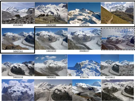
14653410 65319402
58907261
47903616 24694380
39408227
42359812
54833218 78060652 8706176
Figure 6: Images used to compute statistics in Tables 1 and 2. GPS images are within the box, numbers correspond to the ones within the tables. Thei Image within the dashed box, is used for the statistic in Table 3 Unlabelled images are randomly selected within the dataset.
Berndt, D. J. and Clifford, J., 1994. Using dynamic time warping to find patterns in time series. In: KDD workshop.
Boroujeni, N. S., Etemad, S. A. and Whitehead, A., 2012. Robust horizon detection using segmentation for UAV applications. In: CRV.
Bozzini, C., Conedera, M. and Krebs, P., 2011. A new tool for ob-taining cartographic georeferenced data from single oblique pho-tos. CIPA Symposium.
Chippendale, P., Zanin, M. and Andreatta, C., 2008. Spatial and temporal attractiveness analysis through geo-referenced photo alignment. In: IGARSS.
Corripio, J., 2004. Snow surface albedo estimation using terres-trial photography. International Journal of Remote Sensing.
Crandall, D. J., Backstrom, L., Huttenlocher, D. and Kleinberg, J., 2009. Mapping the world’s photos. In: WWW.
Debussche, M., Lepart, J. and Dervieux, A., 1999. Mediterranean landscape changes: evidence from old postcards. Global Ecology and Biogeography.
Friedland, G., Choi, J., Lei, H. and Janin, A., 2011. Multimodal location estimation on flickr videos. In: IWSM.
Hammoud, R., Kuzdeba, S., Berard, B., Tom, V., Ivey, R., Bost-wick, R., HandUber, J., Vinciguerra, L., Shnidman, N. and Smi-ley, B., 2013. Overhead-based image and video geo-localization framework. In: CVPR Workshop.
Hays, J. and Efros, A. A., 2008. Im2gps: estimating geographic information from a single image. In: CVPR.
Jacobs, N., Satkin, S., Roman, N., Speyer, R. and Pless, R., 2007. Geolocating static cameras. In: ICCV.
Kraus, K., 2007. Photogrammetry: geometry from images and laser scans. Walter de Gruyter.
Kull, C., 2005. Historical landscape repeat photography as a tool for land use change research. Norwegian Journal of Geography.
Li, Y., Snavely, N., Huttenlocher, D. and Fua, P., 2012. World-wide pose estimation using 3d point clouds. In: ECCV.
Moreno-Noguer, F., Lepetit, V. and Fua, P., 2008. Pose priors for simultaneously solving alignment and correspondence. In: ECCV.
Produit, T., Tuia, D., De Morsier, F. and Golay, F., 2014. Do geographic features impact pictures location shared on the web? modeling photographic suitabiliy in the swiss alps. In: ICMR.
Produit, T., Tuia, D., Golay, F. and Strecha, C., 2012. Pose es-timation of landscape images using DEM and orthophotos. In: ICCVRS.
Produit, T., Tuia, D., Strecha, C. and Golay, F., 2013. An open tool to register landscape oblique images and generate their syn-thetic model. In: OGRS.
Roush, W., Munroe, J. and Fagre, D., 2007. Development of a spatial analysis method using ground-based repeat photography to detect changes in the alpine treeline ecotone. Arctic, Antarctic, and Alpine Research.
Snavely, N., Seitz, S. and Szeliski, R., 2006. Photo tourism: ex-ploring photo collections in 3D. ACM Transactions on Graphics.
Strecha, C., Pylvanainen, T. and Fua, P., 2010. Dynamic and scalable large scale image reconstruction. In: CVPR.