Committee of Experts on Background document 1 Global Geospatial Information Management Available in English only
Third session
Cambridge, United Kingdom of Great Britain and Northern Ireland 24-26 July 2013
Item 8 of the provisional agenda
Establishment and implementation of standards for the global geospatial information community
The UN-GGIM inventory of issues and
geographic information standardization
Background Document Prepared jointly by the International Organization for Standardization (ISO/TC211), the Open Geospatial Consortium (OGC) and the
International Hydrographic Organization (IHO)
The Secretariat acknowledges with thanks the contributions of Gilles Bessero, Jean Brodeur, Serena Coetzee, Olaf Østensen, Anthony Pharaoh and Carl Reed
1 The designations used and the presentation of material in this publication do not imply the expression of any opinion whatsoever on the part of the Secretariat of the United Nations concerning the legal status of any country, territory, city or area, or of its authorities, or concerning the delimitation of its frontiers or boundaries. The term “country” as used in this publication also refers, as appropriate, to territories and areas.
The UN-GGIM inventory of issues
and
geographic information standardization
Prepared by
ISO/TC 211, Geographic information/Geomatics, in cooperation with the
Open Geospatial Consortium (OGC)
and the
International Hydrographic Organization (IHO)
6 June 2013
Contributing authors:
Contents
1. Introduction...5
2. Standardization of geographic information ...7
2.1 ISO/TC 211 standardization processes and procedures...7
2.2 OGC standardization processes and procedures ...7
2.3 IHO standardization processes and procedures ...8
2.4 Cooperation between the IHO, ISO/TC 211 and the OGC...9
3. Summary of the analysis ... 10
3.1 Existing geographic information standards... 10
3.2 Future areas of standardization... 12
4. Recommendations... 14
Annex A. Tabular overview: Existing geographic information standards and the UN-GGIM issues 15 Annex B. Tabular overview: Identified future areas of geographic information standardization and the UN-GGIM issues ... 22
Annex C. Developing a national, regional and global strategic framework for geospatial information 24 Annex D. Establishing institutional arrangements and legal and common frameworks... 26
D.1 Overview ... 26
D.2 Existing standards... 27
D.3 Identified future areas of standardization ... 29
Annex E. Building capability and capacity, especially in developing countries ... 30
E.1 Overview... 30
E.2 Existing standards and activities ... 30
E.3 Identified future areas of standardization... 31
Annex F. Assuring the quality of geospatial information ... 33
F.1 Overview... 33
F.2 Existing standards and activities ... 33
F.3 Identified future areas of standardization... 34
Annex G. Promoting data sharing, accessibility and dissemination ... 35
G.1 Overview... 35
G.2 Standardizing the geospatial standardization infrastructure... 35
G.3 Standardizing the data models for geographic information ... 35
G.4 Standardizing the management of geographic information... 37
G.5 Standardizing the encoding of geographic information ... 40
G.6 Standardizing tightly coupled access to geographic information... 41
G.7 Standardizing portrayal of geographic information... 42
G.8 Standardizing web services for geographic information ... 42
G.9 Standardizing digital rights management for geographic information... 43
G.10 Standardizing geodetic products ... 43
G.11 Standardizing the interface for positioning instruments and devices ... 44
G.12 Standardizing calibration and validation of sensors... 44
G.13 Standardizing in specific domains of interest... 45
Annex H. Embracing trends in information technology ... 50
H.1 Augmented reality ... 50
H.2 Indoor modelling and navigation ... 50
H.3 Internet of Things ... 50
H.4 Location-based services ... 51
H.5 Mobile Internet ... 51
H.6 Positioning instruments and devices (e.g. GPS)... 51
H.7 Semantic Web... 51
H.8 Sensor Web Enablement (SWE)... 52
H.9 Ubiquitous public access... 53
H.11 E-Navigation ... 53
H.12 Other... 54
Annex I. Promoting geospatial advocacy and awareness... 55
Annex J. Working in partnership with civil society and the private sector ... 56
Annex K. Linking geospatial information to statistics ... 57
K.1 Overview... 57
K.2 Existing standards... 57
K.3 Identified future areas of standardization ... 58
Annex L. Selected terms and definitions from ISO standards ... 59
Annex M. Bibliography ... 60
M.1 References to information about geographic information standardization ... 60
1.
Introduction
In the sixties geographic information in digital form and geographic information systems (GIS) were first introduced for land inventory and management (Coppock et Rhind 1991). Since that time, we have witnessed a constant evolution, not only of the technology, but also the science of geographic information. GIS, geographic information databases, spatial data infrastructures and geospatial web services now provide geolocated information in support of decision making at the global, regional, and local scale. They are applied in diverse areas, including the environment, ecology, agriculture, transport, humanitarian problems, disasters, security and global warming. Geographic information is now widely accessible, shared and reused in many contexts. This is possible because geographic information, systems, and services are interoperable.
Standardization in the realm of geographic information has contributed significantly to the development of interoperability of geographic information (McKee and Buehler 1998; ISO/DIS 19101-1 2019101-12). This complex task addresses multiple facets beginning with the definition of interoperability of geographic information. Then, topics such as fundamental data types for spatial and temporal information, conceptual modelling rules, semantics of real world phenomena, metadata, services, encoding, etc. are developed into standards to set the foundation and building blocks that enable interoperability of geographic information. Standards in geographic information are the underpinning for the development of a spatial data infrastructure (SDI).
There are a number of international organizations with the primary objective of developing standards for geographic information. This is the case for ISO/TC 211, Geographic information/Geomatics (ISO/TC 211), the Open Geospatial Consortium (OGC), and the International Hydrographic Organization (IHO).
The International Organization for Standardization2 (ISO) is the world’s largest developer of voluntary International Standards. International Standards provide state of the art specifications for products, services and good practice, helping to make industry more efficient and effective. Developed through global consensus, they help to break down barriers to international trade. ISO was founded in 1947, and since then has published more than 19,000 International Standards covering almost all aspects of technology and business, from food safety to computers, and agriculture to healthcare, impacting on people’s daily lives. ISO aims to be as inclusive as possible when it comes to its membership. Three member categories, each with a different level of access and influence over the ISO system, allow countries with limited resources or without a fully developed national standards system to still observe and keep up to date with international standardization in ISO. Three quarters of the 163 ISO members are from developing countries.
ISO/TC 211, Geographic information/Geomatics3, is the ISO technical committee responsible for the standardization of geographic information. Its work aims at establishing a structured set of standards for information concerning objects or phenomena that are directly or indirectly associated with a location relative to the Earth. More specifically, it covers semantic, syntactic and service issues, as well as procedural standards, at various levels of abstraction (e.g. geographic feature definition, spatial and temporal objects, coordinate reference systems, metadata, quality, web services, etc.).
The Open Geospatial Consortium4 (OGC) is a voluntary consensus standards organization.
‘Voluntary consensus standards bodies’ are domestic or international organizations, which plan, develop, establish or coordinate voluntary consensus standards using agreed-upon procedures. The focus of OGC work is to define, document and test implementation standards for use with geospatial content and services. OGC standards leverage the abstract standards defined by ISO/TC 211. The work of the OGC is driven by member organization requirements, staff analysis of market trends and OGC Board of Directors guidance. In all cases, the mission is the integration of geospatial content and services into applications for the benefit of mankind. Key new OGC standards focus areas have a definite orientation on accessibility, sustainability and capacity.
The International Hydrographic Organization5 (IHO) is an intergovernmental consultative and technical organization established in 1921 to support safety of navigation and the protection of the marine environment. Among its main objectives, IHO is to bring about the greatest possible uniformity in nautical charts and documents (i.e. standardization). The establishment and maintenance of hydrographic standards rests with the IHO Programme ‘Hydrographic Services and Standards’, under the responsibility of the IHO Hydrographic Services and Standards Committee (HSSC). The provision of hydrographic and nautical chart services is one of the obligations of coastal State signatories to the International Convention for the Safety of Life at Sea (SOLAS) under the responsibility of the International Maritime Organization (IMO). The SOLAS Convention (IMO 2009) stipulates that ‘Contracting Governments undertake to ensure the greatest possible uniformity in charts and nautical publications and to take into account, whenever possible, the appropriate resolutions and recommendations adopted by the International Hydrographic Organization’.
The United Nations initiative on Global Geospatial Information Management6 (UN-GGIM) aims
to play a leading role in setting the agenda for the development of global geospatial information and to promote its use to address key global challenges. Interoperability and standardization in geographic information are essential elements for the development of global geospatial information. Geospatial information exits in many countries and organizations. Access to and reuse of such information can speed up the establishment of global geospatial information. By complying with standards for geographic information, existing geospatial information can be aggregated, arranged and made available more easily to achieve the UN-GGIM aims and objectives. In this context, the inventory of issues to be addressed by the United Nation Committee of Experts on Global Geospatial Information Management has been collated and consolidated within the following nine thematic groups (ECOSOC 2012):
(a) Developing a national, regional and global strategic framework for geospatial information;
(b) Establishing institutional arrangements and legal and common frameworks; (c) Building capability and capacity, especially in developing countries; (d) Assuring the quality of geospatial information;
(e) Promoting data sharing, accessibility and dissemination; (f) Embracing trends in information technology;
(g) Promoting geospatial advocacy and awareness;
(h) Working in partnership with civil society and the private sector; (i) Linking geospatial information to statistics.
At the second session of the UN Committee of Experts on GGIM (UNCE GGIM) in August 2012, in New York City, ISO/TC 211 in cooperation with the OGC and IHO proposed to the committee to develop a report addressing issues related to geographic information standards setting in the international community.
This report is the ISO/TC 211 response, in cooperation with the OGC and the IHO, and intends to provide recommendations regarding standards setting in the global geospatial community to the UNCE GGIM in support of its aims and objectives. It presents an analysis of the standardization needs relevant to the above UN-GGIM issues and currently available standards baselines from ISO/TC 211, the OGC and the IHO.
The remainder of the report is structured as follows: Section 2 describes how ISO/TC 211, the OGC and the IHO operate and cooperate on standardization of geographic information. Section 3 provides a summary of the detailed analysis in the Annexes. Section 4 contains recommendations for consideration by UNCE GGIM.
Annex A and B provide a tabular overview of Annexes C to K in which the contributions from relevant standards to each of the UN-GGIM issues, as well as additional areas of geographic information standardization that could contribute to UN-GGIM issues in future, are described (there is an Annex for each UN-GGIM issue). Annex L provides a subset of ISO terms and definitions used in this document.
Annex M provides a bibliography of references where the reader can find additional information about the geographic information standards and activities described in this report.
2.
Standardization of geographic information
2.1 ISO/TC 211 standardization processes and procedures
ISO technical work is carried out under the overall management of the Technical Management Board (TMB). The TMB reports to the ISO Council and its role is defined in the statutes of the organization. TMB tasks include setting up technical committees, appointing chairs and monitoring the progress of technical work (ISO 2013). The ISO/IEC Directives (ISO/IEC 2011, ISO/IEC 2012) are essentially the rules for the development of International Standards and deal with matters of strategic planning, coordination, performance and monitoring of technical committee activities, as well as rules for the structure and drafting of standards.
ISO standards are developed by groups of experts within technical committees (ISO/TCs). ISO/TCs are made up of representatives of industry, NGOs, governments, academia and other stakeholders, who are put forward by ISO’s members. Each TC deals with a different subject. ISO/TC 2117 is the ISO technical committee responsible for standardization of geographic information. ISO/TC 211 currently has 35 participating members, 31 observing members and liaison relationships with more than 30 international organizations and more than 15 other ISO/TCs. The Vienna agreement (1991) ensures technical cooperation with the European Committee for Standardization (CEN). The European Committee for Standardization (CEN) Technical Committee for geographic information, CEN/TC 287, is the mirror committee to ISO/TC 211, adopts their standards in order to make them mandatory within the European Union and produces technical guidance and best practice for spatial data infrastructures. Once the need for a standard has been established, experts meet face-to-face or through online mechanisms to discuss and negotiate a draft standard. As soon as a draft has been developed, it is shared with ISO’s members who are asked to comment and vote on it. If consensus is reached, the draft becomes an ISO standard, if not, it goes back to the technical committee for further edits. Key principles for the development of standards are that ISO responds to standardization needs in the market (rather than deciding itself when to develop a new standard); ISO standards are based on global expert opinion; ISO standards are developed through a multi-stakeholder process; and ISO standards are based on consensus.
An ISO International Standard embodies the essential principles of global openness and transparency, consensus and technical coherence safeguarded through its development in a technical committee, representative of all interested parties, and supported by a public comment phase (the ISO Technical Enquiry). Other ISO deliverables include the ISO Technical Specification (ISO/TS), the ISO Public Available Specification (ISO/PAS) and the ISO Technical Report (ISO/TR) with lower levels of consensus and therefore not the same status as an International Standard. An Industry Technical Agreement (ITA) aims to bridge the gap between the activities of consortia and the formal process of standardization represented by ISO and its national members. An important distinction is that the ITA is developed by ISO workshops and fora, comprising only participants with direct interest, and is therefore not accorded the status of an International Standard.
2.2 OGC standardization processes and procedures
Founded in 1994 as a 501 (c) (6) not for profit membership based consensus standards organization8, the vision and mission of the OGC is to enable the use and integration of geospatial content and services in any system or application regardless of whether the system or application is single purpose for a given organization or is an enterprise portal application accessible on an international basis. The OGC currently has 480+ Member organizations representing Government, the private sector, universities, NGOs, research communities, and the open source community. The work of the OGC is guided by Member approved Policies and Procedures (P&Ps). These P&Ps are living documents that evolve based on Member and market requirements. However, the fundamental requirement of a collaborative, consensus standards development and maintenance process has remained since 1994.
www.isotc .org
The standards work in the OGC occurs primarily in two major activities: the Interoperability Program and the Standards Program. The Interoperability Program provides a facilitated, rapid engineering (agile) lifecycle approach to capturing interoperability requirements and then using those requirements and use cases to prototype applications (software) that either test existing OGC standards against those requirements, often providing change requests to existing standards; or develop new candidate standards or extensions to existing standards. The work of an interoperability initiative then feeds directly into the standards program.
The Standards Program (SP) is where work on candidate standards and revisions to existing standards occurs. The SP is an open forum for discussion of requirements, use cases, and issues. The SP is also a forum for Members to present on implementations of OGC standards and lessons learned. The SP is comprised of Domain and Standards Working Groups. Domain Working Groups are open to any Member as well as the public (non-Members). Standards Working Groups (SWGs) are for Members only and their work is guided by the OGC P&P and the OGC Intellectual Property policies. SWGs are the working groups in which standards documents are maintained. Candidate standards are submitted by three or more Member organizations. Candidate standards may have been developed outside the OGC (such as KML), developed by the SWG, or submitted as a result of an interoperability initiative. The OGC standards track is well documented in the OGC P&Ps.
All OGC standards, when approved, are freely and publicly available on a Royalty Free, non-discriminatory basis (RAND-RF).
2.3 IHO standardization processes and procedures
The current membership of the IHO is composed of 81 coastal States. The official representatives of Member Governments within the IHO are normally the national Hydrographer, or Director of Hydrography, who, together with their technical staff, meet in Monaco at the International Hydrographic Conference (IHC). The IHC holds ordinary sessions at five-year intervals and extraordinary sessions in the interim period as required. All decisions of the Organization are made by the Member States, during IHC sessions or by postal voting during the inter-sessionary period. Each Member State has one vote in ordinary decision making.
The principles and procedures for developing IHO standards are laid out in a specific resolution9 which was initially approved by IHO Member States in 2007. This resolution applies to “standards” and “guides” as defined by ISO10. The development, consultation and approval process ranges from a very comprehensive regime for new publications and significant changes to existing publications (new editions or revisions), requiring formal approval by a majority of the Member States, to approval at the level of a subordinate body (committee, sub-committee, working group) for simple clarifications. Proposals to develop a new publication, a new edition or a revision are considered by the relevant IHO Committee, generally the Hydrographic Services and Standards Committee (HSSC) but not exclusively. When assessing the proposal, the Committee concerned considers the impact on relevant stakeholders, including a risk and feasibility analysis and an estimate of the resources needed for the development and the implementation of the new or revised standard. After the Committee has endorsed proposals and established a work priority, the relevant tasks are incorporated in the IHO work programme. Relevant stakeholders are notified of the timetable for new work items and invited to comment and participate as appropriate. At the successful completion of the development and testing phases for new standards and proposed changes to existing standards, the Committee reviews the work done in terms of its impact on relevant stakeholders and whether the appropriate non-IHO stakeholder consultation process has been achieved. After endorsement by the Committee, the new or changed standard is submitted to the approval of Member States (simple majority).
Clarifications to standards and associated references are assessed and authorised by the relevant subordinate body, subject to seeking input from relevant stakeholders.
The IHO Secretariat maintains an on-line register of IHO stakeholders used to inform and seek input from stakeholders. Stakeholders include other international organizations, maritime administrations, equipment manufacturers, data distributors, users and professional organizations.
)(O Resolution / as amended ‐ Principles and procedures for making changes to IHO technical
standards and specifications, )(O Publication M‐ , nd Edition , updated to January .
2.4 Cooperation between the IHO, ISO/TC 211 and the OGC
The OGC and the IHO are category A liaisons of ISO/TC 211. Category A liaisons are organizations that make an effective contribution to the work of the technical committee for questions dealt with by the technical committee. Such organizations are given access to all relevant documentation and are invited to meetings. They may nominate experts to participate on the development of standards in working groups (ISO/IEC Directives, Part 1 2012).
The OGC and ISO/TC 211 have a long history of collaboration and development of joint standards documents, the submission of OGC standards to ISO/TC 211 for consideration for approval as International Standards, and the use of ISO/TC 211 developed standards as part of the OGC Abstract Specification, the conceptual foundation for most OGC specification development activities. Open interfaces and protocols are built and referenced against the Abstract Specification, thus enabling interoperability between different brands and different kinds of spatial processing systems.
OGC develops standards that can be directly implemented. Many of these implementation standards are based on the conceptual (or abstract) models defined by ISO or jointly by the OGC and ISO. Therefore, the OGC maintains a Class A Liaison relationship with ISO/TC 211. The terms of the agreement11 are:
- The OGC wishes to obtain ISO International Standard status for its Industry Implementation Standards.
- ISO/TC 211 wishes to adopt appropriate Industry Implementation Specifications as ISO International Standards or other ISO deliverables.
- The OGC wishes, while retaining its market responsiveness, to align with ISO/TC 211 on working practices.
- ISO/TC 211 wishes, within the constraints of the ISO Directives, to co-operate with OGC in assisting the alignment of life cycle working practices.
- The OGC and ISO/TC 211 wish to harmonize and agree their respective work programmes and to set up a group to handle issues under this agreement.
- The OGC and ISO/TC 211 wish to achieve mutual benefit from sharing the expertise of domain experts of the two organisations and they welcome cross-project participation. The current OGC standards baseline and their relationship to the ISO 19100 series of standards is documented in the OGC Reference Model (ORM). The OGC Reference Model (ORM) describes the OGC Standards Baseline focusing on relationships between the baseline documents. The OGC Standards Baseline (SB) consists of the approved OGC Abstract and Implementation Standards (Interface, Encoding, Profile, and Application Schema – normative documents) and OGC Best Practice documents (informative documents).
The cooperation between IHO and ISO/TC 211 has been driven by the development of standards for digital hydrographic information and products. The IHO recognized the benefits of developing standards based on some or all of the parts of the ISO 19100 series or other related standards and both organizations agreed to formalize their cooperation through a Memorandum of Understanding12 in order to strengthen the joint development of international standards and to avoid duplication of work on standards related to hydrography and nautical charting and related data, products and services. As a category A liaison organization to ISO/TC 211, IHO members, IHO technical staff, and IHO nominated experts attend ISO/TC 211 working groups and plenary meetings and participate in the work in a non-voting capacity. IHO liaison to ISO/TC 211 provides overall co-ordination of this activity within IHO.
As an accredited Non Governmental International Organization, ISO/TC 211 representatives participate as non-voting liaison members in the IHO committees and working groups so that reciprocal liaison is achieved.
Reports on the work of the IHO are given at each relevant ISO/TC 211 plenary or working group meeting; reciprocally, and conversely, reports on the work of ISO/TC 211 are given at each relevant IHO meeting.
http://www.isotc .org/Agreements/Agreement_OGC.pdf
3.
Summary of the analysis
This section provides a summary of the detailed analysis in Annexes C to K of this report. Section 3.1 provides an overview of existing IHO, ISO and OGC geographic information standards and their contribution to UN-GGIM issues. Section 3.2 presents an overview of identified future areas of geographic information standardization, indicating for each one to which UN-GGIM issues they could potentially contribute.
3.1 Existing geographic information standards
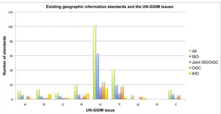
Table 1 and Figure 1 provide an overview of existing geographic information standards contributing to UN-GGIM issues. The contributions are described in detail in Annexes C to K. A short summary is provided at the end of this section
Table 1. Existing geographic information standards and the UN-GGIM issues
UN-GGIM issue Number of standards
ISO OGC IHO
(a) Developing a national, regional and global strategic framework for geospatial information
6 5 1
(b) Establishing institutional arrangements and legal and common frameworks
5 2 7
(c) Building capability and capacity, especially in developing countries 5 2 2
(d) Assuring the quality of geospatial information 7 6 8
(e) Promoting data sharing, accessibility and dissemination 63 24 15
(f) Embracing trends in information technology 20 18 3
(g) Promoting geospatial advocacy and awareness - 4 2
(h) Working in partnership with civil society and the private sector - - -
(i) Linking geospatial information to statistics 7 6 -
The IHO, ISO and OGC standards address all the UN-GGIM identified issues, although naturally the primary focus is on issue (e) Promoting data sharing, accessibility and dissemination. It is important to note the comparatively high number of standards contributing to issue (f) Embracing trends in
information technology, which confirms that in the geospatial community, similar to other
Figure 1. Existing geographic information standards and the UN-GGIM issues
(a) Developing a national, regional and global strategic framework for geospatial information
IHO recommendations address strategic frameworks relevant to geographic information in two areas: the provision of a Worldwide Electronic Navigational chart Database (WEND) and the development of Maritime Spatial Data Infrastructures (MSDI). A number of ISO standards, such as the reference model, the conceptual schema language and terminology, provide the foundations for standardization in geographic information. The SDI Cookbook published by the Global Spatial Data Infrastructure Association is an implementation guide (or ‘cookbook’) for spatial data infrastructures (SDI). The SDI Cookbook provides geographic information providers and users with the background information to evaluate and implement existing components of SDI, including standards.
(b) Establishing institutional arrangements and legal and common frameworks
The institutional framework for the provision of hydrographic and nautical chart services follows from the IMO SOLAS Convention (IMO 2009). Neither the OGC nor ISO has specific standards for establishing institutional arrangements and/or legal and common frameworks. However, both organizations have processes (policies and procedures) that can be used to develop consensus based, domain based, institutional agreements on domain specific models and encodings for sharing specific themes (or layers) of geographic information.
(c) Building capability and capacity, especially in developing countries
Standardized terminology is essential for unambiguous communication in professional activities, as well as in education and training. The terminology defined in IHO, ISO and OGC standards thus supports capability and capacity building. Standards exist for cross-mapping vocabularies of geographic information science and statistics, as well as vocabularies used among the multiple disciplines involved in sustainability science. The IHO, ISO and the OGC have measures in place to ensure that developing countries can participate or observe in standardization. Finally, outreach activities of the three organizations inform the geospatial community of geographic information standards.
(d) Assuring the quality of geospatial information
ISO standards for measuring quality and quality assurance of geographic information have been developed by ISO/TC 211 and the OGC, while most IHO standards related to hydrographic data and products include quality considerations. The ISO quality standards for geographic information are based on the general quality management principles defined in ISO 9000. As noted above, following standards per se already contributes to the quality of geographic information.
(e) Promoting data sharing, accessibility and dissemination
of geographic information; tightly coupled access to geographic information; portrayal of geographic information; the digital rights management of geographic information; geodetic products; and the calibration and validation of sensors. Standards in specific domains of interest, such as addressing, land administration and climate change are emerging, while there are a considerable number of standards for hydrographic and nautical chart services. Some of these standards are jointly developed between the IHO, ISO and/or OGC. Standards are implemented in thousands of services, portals, and other applications. Content from existing OGC standards are now also included as elements in standards from other standards organizations, such as the Internet Engineering Task Force (IETF) and Organization for the Advancement of Structured Information Standards (OASIS).
(f) Embracing trends in information technology
A variety of ongoing standards development activities in the IHO, ISO and the OGC are related to facilitating interoperability in new and/or emerging technology areas, such as augmented reality, location-based services, the semantic web, sensor web enablement and e-navigation. Resulting standards have the potential to enhance the ability to provide access to geographic data and resources to many more organizations and citizens on a global scale.
(g) Promoting geospatial advocacy and awareness
Outreach activities in the three organizations are relevant here. The IHO has published two standards contributing to the promotion of geospatial advocacy and awareness.
(h) Working in partnership with civil society and the private sector
There are no specific standards for this issue, but consensus based standards development with representatives from the private and public sector, research institutes, academia and other stakeholders, is a collaborative effort with civil society and the private sector.
(j) Linking geospatial information to statistics
This issue is concerned with linking or combining different metadata conventions and systems for geospatial and statistical information, as well as combining statistical databases with geoportals containing spatial datasets. ISO metadata standards for geographic information are implemented in many geoportals and thus relevant here. The OGC has developed a standard for linking geospatial data, such as census boundaries, with corresponding statistical data.
The level of harmonization and interoperability of hydrographic and nautical chart services on a world-wide basis can be considered as satisfactory. What is far from satisfactory is the limited capacity to collect hydrographic data on a worldwide basis and the number of coastal States that do not have relevant arrangements in place to provide adequate hydrographic surveying and nautical chart services. This not only impacts directly on risks to safety of lives at sea and the protection of the marine environment, but also impedes the sustainable exploitation of the resources of the seas and the oceans - the development of the so-called Blue Economy.
Over the last 30 years the numbers of surveying vessels operated by IHO Member State governments has declined by 34% for offshore vessels and 35% for coastal vessels. This reduction in numbers of vessels has not been offset by either the use of more efficient technology, such as LiDAR or multibeam sensors or through governments opting for commercial survey contracts. An examination of IHO Publication C-55 - Status of Hydrographic Surveying and Nautical Charting Worldwide shows that progress in the amount of sea area surveyed in most States is slow or non-existent. For many coastal States there are very large areas of their waters for which there is little or no hydrographic data. In spite of recurring resolutions of the UN General Assembly and decisions of the IMO Council urging coastal States to fulfill their obligations, progress is slow as governments of developing countries face more pressing needs in a context of increasing national budgetary constraints and reduced international aid. Out of 151 States in the world with significant coastlines, only 81 have so far become Members of the IHO.
3.2 Future areas of standardization
ISO responds to standardization needs in the market, rather than deciding itself when to develop a new standard. The ISO/TC 211 Programme Maintenance Committee (PMG) monitors the ISO 19100 series of published standards and standards under development to ensure harmonization and consistency. The PMG also monitors changing requirements and technological developments to ensure that the TCs programme of work is aligned to these.
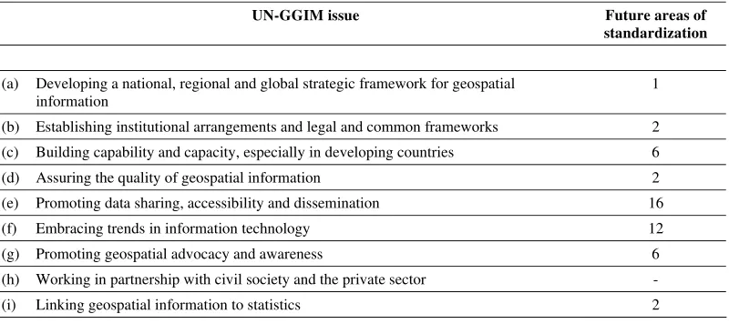
For this report a number of future areas of standardization were identified. This is not a comprehensive list, but gives an idea of standardization that could contribute to resolving UN-GGIM issues in future. Table 2 presents a statistical overview of the identified areas of standardization. A short summary of the future areas of standardization described in Annexes C to K is provided at the end of this section. Table 2. Future areas of geographic information standardization and the UN-GGIM issues
UN-GGIM issue Future areas of
standardization
(a) Developing a national, regional and global strategic framework for geospatial information
1
(b) Establishing institutional arrangements and legal and common frameworks 2
(c) Building capability and capacity, especially in developing countries 6
(d) Assuring the quality of geospatial information 2
(e) Promoting data sharing, accessibility and dissemination 16
(f) Embracing trends in information technology 12
(g) Promoting geospatial advocacy and awareness 6
(h) Working in partnership with civil society and the private sector -
(i) Linking geospatial information to statistics 2
(a) Developing a national, regional and global strategic framework for geospatial information
UN member countries should be encouraged to leverage and build upon existing geospatial standardization initiatives in the IHO, ISO and the OGC.
(b) Establishing institutional arrangements and legal and common frameworks
Various frameworks for the standardization of geographic information exist and these need to be described and developed into best practices so that communities can take informed decisions when deciding on a framework to suit their needs. Management system standards describe processes and procedures to ensure that an organization fulfils tasks required to achieve set objectives. Such standards would not only contribute to establishing frameworks, but also to build capacity and capability, assuring the quality of information and to promote geospatial advocacy and awareness.
(c) Building capability and capacity, especially in developing countries
Terminology, standards and training material need to be translated into many more languages. Standardized descriptions of geospatial knowledge, skills and competencies are required for capacity building so that, amongst others, qualifications can be compared and training material can be developed accordingly. Additional cross-mappings between vocabularies of multiple disciplines are required. Collaboration on outreach activities between IHO, ISO, the OGC and UN-GGIM would be beneficial to all. See also management system standards under (b) above.
(d) Assuring the quality of geospatial information
There is a need to quantify and qualify the provenance of crowd sourced content. Quality standards tailored for crowd sourced information could contribute to this need. See also management system standards under (b) above.
(e) Promoting data sharing, accessibility and dissemination
information and the calibration and validation of sensors has been initiated. Other future areas of standardization are in the field of license agreements for geographic information, geodetic references and LiDAR. See also translations, outreach, cross-mappings and standardized descriptions of knowledge, skills and competencies under (e) above, as well as an ISO standard for administrative boundaries in (j) below.
(f) Embracing trends in information technology
Standard development activities in new and emerging technology described earlier are also relevant here. Amongst others, augmented reality, location-based services, the semantic web, sensor web enablement and e-navigation are included.
(g) Promoting geospatial advocacy and awareness
See under (b) above. See also translations, outreach and standardized descriptions of knowledge, skills and competencies under (e) above
(h) Working in partnership with civil society and the private sector
n/a
(j) Linking geospatial information to statistics
The development of an ISO standard for the second administrative level boundaries (http://www.unsalb.org/) dataset developed by the UN Geographic Information Working Group (UN GIWG) was identified. See also cross-mappings under (e) above.
4.
Recommendations
The IHO, ISO and the OGC welcome input on requirements, use cases, issues, change requests and any other form of community input from the UNCE GGIM or UN member nations to make standards better and as relevant as possible to UN-GGIM issues. Active engagement from the UNCE GGIM at a strategic and/or technical level is encouraged to assist in crafting and evolving the respective standards baseline to match UN-GGIM requirements. With this in mind, ISO/TC 211 invites the UNCE GGIM to become an ISO/TC 211 Category A liaison in order to influence and benefit from the ISO/TC 211 work.
Consistent policy (similar to INSPIRE in EUROPE) and best practices for standards
implementation advocated by the UNCE GGIM is needed to facilitate the interoperability of
standards implemented in one region or country with those from another region or country.
Continued outreach and education is essential and the three organizations recommend
UN-GGIM collaboration with existing activities. With the increasing emergence of mobile based
applications, the outreach and education is not with the end user but with the organizations that maintain the infrastructure and develop the applications the end users access.
Noting that 71% of the surface of the planet is occupied by seas and oceans it is recommended that UN-GGIM acknowledges that the UN initiative on Global Geospatial Information Management includes the maritime dimension and welcomes the contribution of the International Hydrographic Organization (IHO) to the provision and development of standards, information, products and services related to hydrography and nautical charting.
Noting that recurring resolutions of the UN General Assembly encouraging States to work with IHO to increase the coverage of hydrographic information on a global basis have had little or no impact on States that have not yet become members of the IHO and that current IHO Member States are tempted to reduce their involvement for short term savings, it is recommended that UN-GGIM urges States
to address as a matter of priority the critical need to improve hydrographic services and the
Annex A.
Tabular overview: Existing geographic information standards and
the UN-GGIM issues
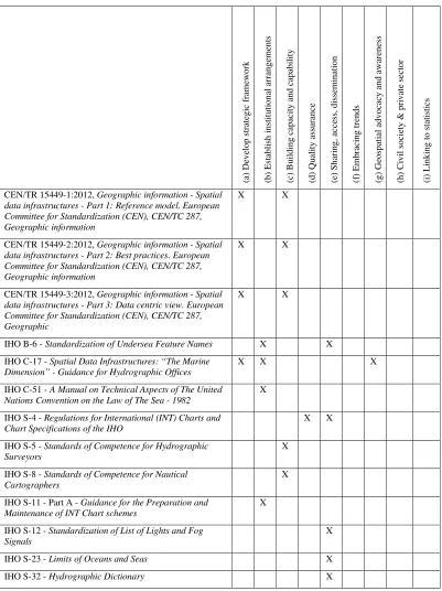
Table 3 lists ISO, OGC and IHO standards alphabetically, indicating to which UN-GGIM issue each contributes. This is a summary of the contributions described in Annexes C to K. There is an Annex for each issue. For each ‘X’ in the table below, the corresponding contribution is described in the relevant Annex.
Table 2. Existing geographic information standards and the UN-GGIM issues
(a) D
CEN/TR 15449-1:2012, Geographic information - Spatial data infrastructures - Part 1: Reference model. European Committee for Standardization (CEN), CEN/TC 287, Geographic information
X X
CEN/TR 15449-2:2012, Geographic information - Spatial data infrastructures - Part 2: Best practices. European Committee for Standardization (CEN), CEN/TC 287, Geographic information
X X
CEN/TR 15449-3:2012, Geographic information - Spatial data infrastructures - Part 3: Data centric view. European Committee for Standardization (CEN), CEN/TC 287, Geographic
X X
IHO B-6 - Standardization of Undersea Feature Names X X
IHO C-17 - Spatial Data Infrastructures: “The Marine Dimension” - Guidance for Hydrographic Offices
X X X
IHO C-51 - A Manual on Technical Aspects of The United Nations Convention on the Law of The Sea - 1982
X
IHO S-4 - Regulations for International (INT) Charts and Chart Specifications of the IHO
X X
IHO S-5 - Standards of Competence for Hydrographic Surveyors
X
IHO S-8 - Standards of Competence for Nautical Cartographers
X
IHO S-11 - Part A - Guidance for the Preparation and Maintenance of INT Chart schemes
X
IHO S-12 - Standardization of List of Lights and Fog Signals
X
IHO S-23 - Limits of Oceans and Seas X
(a) Develop strategic
IHO S-44 - Standards for Hydrographic Surveys X
IHO S-49 - Standardization of Mariners' Routeing Guides X
IHO S-52 - Specifications for Chart Content and Display Aspects of ECDIS
X
IHO S-53 - Joint IMO/IHO/WMO Manual on Maritime Safety Information
X
IHO S-57 - Transfer Standard for Digital Hydrographic Data
X X
IHO S-58 - Recommended ENC Validation Checks X
IHO S-60 - Users Handbook on Datum Transformations involving WGS 84
X
IHO S-61 - Product Specifications for Raster Navigational Charts (RNC)
X
IHO S-63 - Data Protection Scheme X
IHO S-64 - Test Data Sets for ECDIS X
IHO S-65 - ENC Production Guidance X X X
IHO S-66 - Facts about Electronic Charting and Carriage Requirements
X
IHO S-99 - Operational Procedures for the Organization and Management of the IHO Geospatial Information Registry
X
IHO S-100 - Universal Hydrographic Data Model X X
IHO S-101 - ENC Product Specification (in development) X X X
IHO S-102 - Bathymetric Surface Product Specification X X X
ISO/DIS 19101-1, Geographic information -- Reference model -- Part 1: Fundamentals
X X
ISO 19101-2:2008, Geographic information -- Reference model -- Part 2: Imagery
X X
ISO/TS 19103, Geographic information -- Conceptual schema language
X X
ISO/TS 19104:2008, Geographic information -- Terminology
X X X
ISO 19105:2000, Geographic information -- Conformance and testing
X X
(a) Develop strategic
ISO 19107:2003, Geographic information -- Spatial schema (approved by OGC Members as a topic volume in the OGC Abstract Specification)
X
ISO 19108:2002, Geographic information -- Temporal schema
X
ISO 19109:2005, Geographic information -- Rules for application schema
X
ISO 19110:2005, Geographic information -- Methodology for feature cataloguing
X
ISO 19111:2007, Geographic information -- Spatial referencing by coordinates (approved by OGC Members as a topic volume in the OGC Abstract Specification)
X
ISO 19111-2:2009, Geographic information -- Spatial referencing by coordinates -- Part 2: Extension for parametric value (joint ISO/OGC document)
X X X
ISO 19112:2003, Geographic information -- Spatial referencing by geographic identifiers
X
ISO 19115:2003, Geographic information -- Metadata (approved by OGC Members as a topic volume in the OGC Abstract Specification)
X X X X
ISO 19115-1, Geographic information -- Metadata -- Part 1: Fundamentals
X X X X
ISO 19115-2:2009, Geographic information -- Metadata -- Part 2: Extensions for imagery and gridded data
X X X X
ISO 19115-3, Geographic information -- Metadata -- Part 3: XML schema implementation of metadata fundamentals
X X X X
ISO 19116:2004, Geographic information -- Positioning services
X X
ISO 19117:2012, Geographic information -- Portrayal X
ISO 19118:2011, Geographic information -- Encoding X
ISO 19119:2005, Geographic information -- Services. (approved by OGC Members as a topic volume in the OGC Abstract Specification)
X
ISO/TR 19122:2004, Geographic information/ Geomatics -- Qualification and certification of personnel
X
ISO 19123:2005, Geographic information -- Schema for coverage geometry and functions
X
ISO 19125-1:2004, Geographic information -- Simple feature access -- Part 1: Common architecture (OGC standard submitted to ISO/TC 211)
(a) Develop strategic
ISO 19125-2:2004, Geographic information -- Simple feature access -- Part 2: SQL option (OGC standard submitted to ISO/TC 211)
X X
ISO 19126:2009, Geographic information -- Feature concept dictionaries and registers
X
ISO/TS 19127:2005, Geographic information -- Geodetic codes and parameters
X X
ISO 19128:2005, Geographic information -- Web Map Server interface (OGC standard submitted to ISO/TC 211)
X X
ISO/TS 19129:2005, Geographic information -- Imagery, gridded and coverage data framework
X
ISO/TS 19130:2010, Geographic information -- Imagery sensor models for geopositioning
X
ISO/TS 19130-2, Geographic information -- Imagery sensor models for geopositioning -- Part 2: SAR, InSAR, Lidar and sonar
X
ISO 19131:2007, Geographic information -- Data product specifications
X
ISO 19132:2007, Geographic information -- Location-based services – Reference model
X X
ISO 19133:2005, Geographic information -- Location-based services -- Tracking and navigation
X X
ISO 19134:2007, Geographic information -- Location-based services -- Multimodal routing and navigation
X X
ISO 19135:2005, Geographic information -- Procedures for item registration
X
ISO/TS 19135-2:2012, Geographic information -- Procedures for item registration -- Part 2: XML Schema Implementation
X
ISO 19136:2007, Geographic information -- Geography Markup Language (GML) (OGC standard submitted to ISO/TC 211)
X X
ISO 19136-2, Geographic information -- Geography Markup Language (GML) -- Part 2: Extended schemas and encoding rules (OGC standard submitted to ISO/TC 211)
X X
ISO 19137:2007, Geographic information -- Core profile of the spatial schema
X
ISO/TS 19139, Geographic information -- Metadata -- XML schema implementation
(a) Develop strategic
ISO/TS 19139-2:2012, Geographic information -- Metadata -- XML Schema Implementation -- Part 2 : Extensions for imagery and gridded data
X X
ISO 19141:2008, Geographic information -- Schema for moving features
X
ISO 19142:2010, Geographic information -- Web Feature Service (OGC standard submitted to ISO/TC 211)
X X
ISO 19143: 2010, Geographic information -- Filter encoding (OGC standard submitted to ISO/TC 211)
X X
ISO 19144-1:2009, Geographic information -- Classification systems -- Part 1: Classification system structure
X
ISO 19144-2:2012, Geographic information -- Classification systems -- Part 2: Land Cover Meta Language (LCML)
X
ISO 19145, Geographic information -- Registry of representations of geographic point locations
X
ISO 19146:2010, Geographic information -- Cross-domain vocabularies
X X X
ISO 19147, Geographic information -- Transfer Nodes X
ISO 19148:2012, Geographic information -- Linear Referencing. (approved by OGC Members as a topic volume of the OGC Abstract Specification)
X
ISO 19149:2011, Geographic information -- Rights expression language for geographic information – GeoREL (OGC standard submitted to ISO/TC 211)
X X X
ISO 19150-1, Geographic information -- Ontology -- Part 1: Framework
X X
ISO 19150-2, Geographic information -- Ontology -- Part 2: Rules for developing ontologies in the Web Ontology Language (OWL)
X X
ISO 19152:2012, Geographic information -- Land Administration Domain Model (LADM)
X
ISO 19153, Geospatial Digital Rights Management Reference Model (GeoDRM RM) (OGC standard submitted to ISO/TC 211)
X X X
ISO 19155:2012, Geographic information -- Place Identifier (PI) Architecture
X X
ISO 19156:2011, Geographic information -- Observations and measurements. (OGC standard submitted to ISO/TC 211)
X
(a) Develop strategic
ISO/TS 19158:2012, Geographic information -- Quality assurance of data supply
X
ISO 19159-1, Geographic information -- Calibration and validation of remote sensing imagery sensors -- Part 1: Optical sensors
X
ISO 19160-1, Addressing -- Part 1: Conceptual model X
ISO 19161, Geodetic references (preliminary stage) X X
ISO 19162, Geographic information -- Well known text representation of coordinate reference systems (Joint OGC-ISO/TC 211 project)
X X
ISO 19163, Geographic information -- Content components and encoding rules for imagery and gridded data
X
ISO 6709:2008, Standard representation of geographic point location by coordinates
X
OGC Catalogue Service Interface Standard X X X X X X
OGC CityGML 2.0 Encoding Standard X X X X X
OGC GeoAPI X X
OGC GeoSPARQL Encoding Standard X X
OGC GeoXACML Encoding Standard X X
OGC GML in JPEG 2000 Encoding Standard X
OGC KML 2.2 Encoding standard X X X X X
OGC Open GeoSMS Encoding Standard (submitted to the ITU for consideration as an International Standard)
X X X X
OGC OpenLS Interface Standard X X
OGC Ordering Service Interface Standard X
OGC OWS Common X
OGC PUCK protocol standard X
OGC SensorML Encoding Standard. Being submitted to JTC 1 WG7 for consideration as an International Standard
X X X X
OGC Sensor Observation Service Interface Standard. Being submitted to JTC 1 WG7 for consideration as an International Standard
X X X X
OGC Sensor Planning Service. Being submitted to JTC 1 WG7 for consideration as an International Standard
X X X
(a) Develop strategic
OGC SWE Common Data Model. Being submitted to JTC 1 WG7 for consideration as an International Standard
X X
OGC SWE Service Model. Being submitted to JTC 1 WG7 for consideration as an International Standard
X X
OGC Table Joining Service Interface Standard X X
OGC WaterML 2.0 Encoding Standard. Being submitted to WMO for consideration as a WMO international standard
X X X X X X X X
OGC Web Coverage Service Interface Standard X X
OGC Web Map Context Encoding Standard X X
OGC Web Map Tile Service Interface Standard X X
Annex B.
Tabular overview: Identified future areas of geographic
information standardization and the UN-GGIM issues
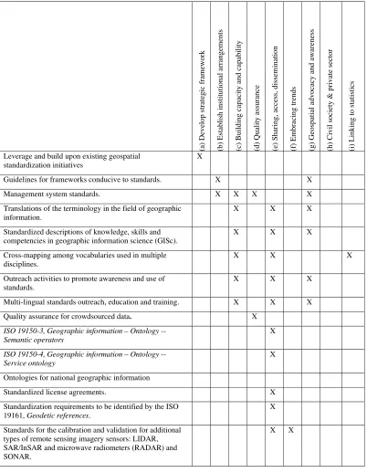
Table 4 lists identified areas of standardization that could contribute to resolving UN-GGIM issues in future. This is a summary of the standardization areas identified and described in Annexes C to K. There is an Annex for each issue. For each ‘X’ in the table below, the corresponding standardization area and its potential contribution to the UN-GGIM issue is described in the relevant Annex.
Table 4. Identified future areas of geographic information standardization and the UN-GGIM issues
(a)
Leverage and build upon existing geospatial standardization initiatives
X
Guidelines for frameworks conducive to standards. X X
Management system standards. X X X X
Translations of the terminology in the field of geographic information.
X X X
Standardized descriptions of knowledge, skills and competencies in geographic information science (GISc).
X X X
Cross-mapping among vocabularies used in multiple disciplines.
X X X
Outreach activities to promote awareness and use of standards.
X X X
Multi-lingual standards outreach, education and training. X X X
Quality assurance for crowdsourced data. X
ISO 19150-3, Geographic information – Ontology -- Semantic operators
X
ISO 19150-4, Geographic information – Ontology -- Service ontology
X
Ontologies for national geographic information
Standardized license agreements. X
Standardization requirements to be identified by the ISO 19161, Geodetic references.
X
Standards for the calibration and validation for additional types of remote sensing imagery sensors: LIDAR, SAR/InSAR and microwave radiometers (RADAR) and SONAR.
(a) D
Standardization requirements identified by the ISO 19160, Addresses: ISO 19160-2, Good practices for address assignment schemes.
X
Standardization requirements identified by the ISO 19160, Addresses: ISO 19160-3, Quality management for address data.
X
Standardization requirements identified by the ISO 19160, Addresses:ISO 19160-5, Address rendering for purposes other than mail.
X
Standardization of essential climate variables. X X
Standardization requirements identified by the review summary report of ISO 19154.
X X
ISO standardized representation of boundaries to which statistical data is linked.
X X
Annex C.
Developing a national, regional and global strategic framework for
geospatial information
While there are no specific ISO/TC 211 or OGC standards for defining strategic frameworks for geographic information, the SDI Cookbook published by the Global Spatial Data Infrastructure Association13 is an implementation guide (or ‘cookbook’) for spatial data infrastructures (SDI). Through the support of the global GSDI community, the SDI Cookbook provides geographic information providers and users with the background information to evaluate and implement existing components of SDI, including standards:
‘To enable builders of SDI to make use of and build on existing SDI components in a way which makes their endeavors compatible with the efforts of other SDI builders, this GSDI Cookbook identifies:
- existing and emerging standards,
- open-source and commercial standards-based software solutions, - supportive organisational strategies and policies and
- best practices.
Working within a common framework of standards and tools based on these standards also makes it possible to maximize the impact of the total available resources for SDI creation through future co-operation -- e.g. we develop this, you develop that, and then we share. Although proprietary or project-based solutions for information sharing continue to exist, the adoption of consistent geospatial data sharing principles will in general provide a better solution for information dissemination, through publishing geospatial data using the Internet and computer media. In an increasingly “global community”, there is a need to ensure that transnational implementations and common knowledge bases are available. Ultimately, these SDI activities should improve collaboration within the geospatial data industry and make the benefits derived from the use of geographic information part of everyday life for all.’ (GSDI 2012)
Chapter 10 of the SDI Cookbook (recently updated) focuses on the identification of compatible, mature geospatial standards that allow maximum technical interoperability based on general evaluation criteria. This chapter defines an SDI standards baseline of mature, widely implemented standards. This baseline is intended for all SDI communities interested in providing and accessing geospatial data over the Internet. The baseline of standards is comprised of key standards from the World Wide Web Consortium (W3C), ISO/TC 211 and the OGC.
The SDI Cookbook also touches on legal issues and economic policy (chapter 8), access and delivery (chapter 6), outreach and building capacity (chapter 9), and other issue areas of concern to the UN-GGIM community.
IHO recommendations address strategic frameworks relevant to geographic information in two areas: the provision of a Worldwide Electronic Navigational chart Database (WEND) and the development of Maritime Spatial Data Infrastructures (MSDI).
The purpose of WEND is to ensure a world-wide consistent level of high-quality, updated official Electronic Navigational Charts (ENC) through integrated services that support chart carriage requirements defined in Chapter V of the Convention for Safety of Life at Sea (SOLAS) of the International Maritime Organization (IMO) and the requirements of the IMO Performance Standards for Electronic Chart Display and Information Systems (ECDIS). IHO Resolutions 1/1997 (as amended)
- Principles of the Worldwide Electronic Navigational chart Database (WEND) and 2/2012 -
Reaffirmation of the IHO’s commitment to full ENC coverage14 set out the relevant strategic principles and guidelines to be implemented by Member States.
IHO Publication C-17 - Spatial Data Infrastructures: “The Marine Dimension” - Guidance for
Hydrographic Offices, listed in Annex B, provides background information and guidance for
developing the maritime component of SDI. It seeks to explain the way in which Hydrographic Offices (HO) might promote, support and participate in SDI through practical advice, simple step by step processes, useful links to reference material and examples of best practice. The options considered include having, or seeking to take on, a leading role in SDI development, seeking to support an existing SDI initiative or working with others to develop an SDI. In all cases, HOs should be seen as the competent authority concerning the provision of hydrographic and related data under any national and/or regional SDI. Working in an SDI environment as described in this document can provide a useful template to developing an SDI capability within individual HOs. An HO could choose to participate at the national or regional level in order to enjoy the shared benefits such an association might bring.
Annex D.
Establishing institutional arrangements and legal and common
frameworks
D.1 Overview
Neither the OGC nor ISO has specific standards for establishing institutional arrangements and/or legal and common frameworks. However, both organizations have processes (policies and procedures) that can be used to develop consensus based, domain based, institutional agreements on domain specific models and encodings for sharing specific themes (or layers) of geographic information.
Many of the ISO and OGC standards can be used to institutionalize or guide such arrangements as codified in standards, best practice use, policy statements or rights management for geographic information and related services. Particularly relevant standards are described in section D.2 but many of the other standards described in the subsequent annexes can obviously also be used. This approach suggests that any organization, country or region first needs to specify policies related to sharing geographic information and services. Such policies would need to consider intellectual property, copyright, open data, data for fee structures, service access, and so forth.
Once policies and governance are in place, then activities such as defining reference architectures (common framework) and access control can be defined. There are numerous national or trans-national examples of this approach. For example, the Canada Geospatial Data Infrastructure (CGDI), the Catalonian SDI, and INSPIRE (Infrastructure for Spatial Information in Europe) are examples of how a country or a region can define institutional arrangements and common architectures and frameworks that are codified in policy and expressed in the best use practices for a standards baseline.
The OGC staff and Members have developed a number of reference architectures for spatial data infrastructures. These reference architectures provide patterns for defining a framework of technical governance, policy development, and specific implementation architectures. Examples of such reference architectures are publicly available and have been used to develop and document national and regional policy and standards and SDI governance in a number of countries and regions. Examples include:
- Spatial Interoperability Demonstration Project (SIDP), Australia, 200315
- Sensors Anywhere Architecture Guidance (tied to INSPIRE directives), Europe, 201016 - Reference Model for the ORCHESTRA Architecture (tied to INSPIRE), Europe, 201117 Most recently the OGC released the Reference Architecture Profiler (RAP)18. The RAP Advisor is a web based application that recommends OGC Standards and ORM Sections that are relevant to system development, such that a community of interest can derive and build a profile of suitable OGC standards to meet their specific needs. Such a tool helps meet requirements related to many of the key UN-GGIM issues. Another source of information is provided by the technical reports (CEN/TR 15449-1:2012, CEN/TR 15449-2:2012, CEN/TR 15449-3:2012) published by CEN/TC 287, Geographic information, describing, amongst others, a reference model and best practice for spatial data infrastructures.
Also relevant here is the Spatial Legal subcommittee of the OGC Board of Directors, which is to address "spatial law and policy issues" that will influence development requirements of the Consortium's technology process.
The institutional framework for the provision of hydrographic and nautical chart services proceeds from the IMO SOLAS Convention (IMO 2009). Namely, SOLAS Chapter V, Regulation 9, requires Contracting Governments to ensure that hydrographic data are available in a suitable and standardized manner in order to satisfy the needs of safe navigation. It requires also that they cooperate and
co-
portal.opengeospatial.org/files/?artifact_id=
ordinate their activities to the greatest possible degree, in order to ensure that hydrographic and nautical information are made available on a world-wide scale.
In addition to the standards mentioned in section D.2, the following IHO documents are relevant to establishing institutional arrangements and legal and common frameworks for geographic information:
- IHO Publication B-7 - GEBCO Guidelines (under revision) describes the framework and procedures for collecting bathymetric data and mapping the Earth's oceans under the GEBCO project. GEBCO (General Bathymetric Chart of the Oceans) is currently a joint project of the IHO and the Intergovernmental Oceanographic Commission (IOC) of UNESCO. Its objective is to provide the most authoritative, publicly-available bathymetry data sets for the world’s oceans through the efforts of an international collaborating community of scientists and hydrographers with the support of their parent organizations.
- IHO Publication C-55 - Status of Hydrographic Surveying and Nautical Charting Worldwide describes the worldwide coverage of surveys and nautical charts and the extent of effective organisations for the timely promulgation of navigational safety information.
- IHO Publication M-2 - The Need for National Hydrographic Services explains the rationale for supporting and investing in hydrography and nautical charting at a national level. It describes the benefits to national development. It also provides suggestions (Chapter 2 - The National Hydrographic Framework) about how a national Hydrographic Service can be established, how to define individual national requirements, and how to decide upon an appropriate level of involvement. It is written for all those that have an interest in the safe and efficient navigation of ships, protection of the marine environment and more generally to the improvement of the global economy through improving the wealth and prosperity of individual States.
- IHO Resolutions 7/1919 (as amended) - Hydrographic Office Arrangements for the exchange and reproduction of nautical products and 1/1997 (as amended) - Principles of the Worldwide Electronic Navigational chart Database (WEND)19 set out the general principles on which arrangements related to cooperation and exchange of data and products between Hydrographic Offices should be based.
D.2 Existing standards
IHO Publication B-6 - Standardization of Undersea Feature Names is a joint publication of the IHO and of the Intergovernmental Oceanographic Commission (IOC) of UNESCO. It includes recommendations for National authorities naming undersea features.
IHO Publication C-17 - Spatial Data Infrastructures: “The Marine Dimension” - Guidance for
Hydrographic Offices, defines in its part 3 (SDI - Make it happen) the minimum requirements in terms of data management that Hydrographic Offices need to consider to operate an MSDI. They include inputs such as policy and plans necessary to deliver metadata, data sharing and exchange mechanisms, levels of data interoperability, network services including “discovery”, “view”, “download”, “invoke” and “transform” and other plans necessary to ensure compliance with SDI requirements (e.g. data licensing, digital rights management, pricing).
IHO Publication C-51 - A Manual on Technical Aspects of The United Nations Convention on the
Law of The Sea – 1982 provides the technical geodetic and hydrographic framework relevant to the understanding and implementation of the United Nations Convention on the Law of the Sea of 1982, notably to determine and chart baselines and maritime limits and boundaries. This publication is maintained by the Advisory Board on the Law of the Sea (ABLOS) of the IHO and the International Association of Geodesy (IAG)
IHO Publication S-11 - Part A - Guidance for the Preparation and Maintenance of INT Chart
schemes describes the principles and procedures for developing and maintaining regional chart schemes of paper nautical charts in order to obtain an optimized world coverage of international charts at medium and large scales for all of the world's main shipping routes, ports and port approaches.