Open Geospatial Consortium Inc.
Date: 2008-04-14
Reference number of this OGC® project document: OGC 07-147r2
Version: 2.2.0
Category: OGC® Standard
Editor: Tim Wilson
OGC® KML
Copyright © 2007,2008 Open Geospatial Consortium, Inc. All Rights Reserved. To obtain additional rights of use, visit
Document type: OGC® Standard
Document subtype: Encoding
Document stage: OGC® Standard
ii Copyright © 2012 Open Geospatial Consortium License Agreement
Permission is hereby granted by the Open Geospatial Consortium, ("Licensor"), free of charge and subject to the terms set forth below, to any person obtaining a copy of this Intellectual Property and any associated documentation, to deal in the Intellectual Property without restriction (except as set forth below), including without limitation the rights to implement, use, copy, modify, merge, publish, distribute, and/or sublicense copies of the Intellectual Property, and to permit persons to whom the Intellectual Property is furnished to do so, provided that all copyright notices on the intellectual property are retained intact and that each person to whom the Intellectual Property is furnished agrees to the terms of this Agreement.
If you modify the Intellectual Property, all copies of the modified Intellectual Property must include, in addition to the above copyright notice, a notice that the Intellectual Property includes modifications that have not been approved or adopted by LICENSOR.
THIS LICENSE IS A COPYRIGHT LICENSE ONLY, AND DOES NOT CONVEY ANY RIGHTS UNDER ANY PATENTS THAT MAY BE IN FORCE ANYWHERE IN THE WORLD.
THE INTELLECTUAL PROPERTY IS PROVIDED "AS IS", WITHOUT WARRANTY OF ANY KIND, EXPRESS OR IMPLIED, INCLUDING BUT NOT LIMITED TO THE WARRANTIES OF MERCHANTABILITY, FITNESS FOR A PARTICULAR PURPOSE, AND NONINFRINGEMENT OF THIRD PARTY RIGHTS. THE COPYRIGHT HOLDER OR HOLDERS INCLUDED IN THIS NOTICE DO NOT WARRANT THAT THE FUNCTIONS CONTAINED IN THE INTELLECTUAL PROPERTY WILL MEET YOUR REQUIREMENTS OR THAT THE OPERATION OF THE INTELLECTUAL PROPERTY WILL BE UNINTERRUPTED OR ERROR FREE. ANY USE OF THE INTELLECTUAL PROPERTY SHALL BE MADE ENTIRELY AT THE USER’S OWN RISK. IN NO EVENT SHALL THE COPYRIGHT HOLDER OR ANY CONTRIBUTOR OF INTELLECTUAL PROPERTY RIGHTS TO THE INTELLECTUAL PROPERTY BE LIABLE FOR ANY CLAIM, OR ANY DIRECT, SPECIAL, INDIRECT OR CONSEQUENTIAL DAMAGES, OR ANY DAMAGES WHATSOEVER RESULTING FROM ANY ALLEGED INFRINGEMENT OR ANY LOSS OF USE, DATA OR PROFITS, WHETHER IN AN ACTION OF CONTRACT, NEGLIGENCE OR UNDER ANY OTHER LEGAL THEORY, ARISING OUT OF OR IN CONNECTION WITH THE IMPLEMENTATION, USE, COMMERCIALIZATION OR PERFORMANCE OF THIS INTELLECTUAL PROPERTY.
This license is effective until terminated. You may terminate it at any time by destroying the Intellectual Property together with all copies in any form. The license will also terminate if you fail to comply with any term or condition of this Agreement. Except as provided in the following sentence, no such termination of this license shall require the termination of any third party end-user sublicense to the Intellectual Property which is in force as of the date of notice of such termination. In addition, should the Intellectual Property, or the operation of the Intellectual Property, infringe, or in LICENSOR’s sole opinion be likely to infringe, any patent, copyright, trademark or other right of a third party, you agree that LICENSOR, in its sole discretion, may terminate this license without any compensation or liability to you, your licensees or any other party. You agree upon termination of any kind to destroy or cause to be destroyed the Intellectual Property together with all copies in any form, whether held by you or by any third party.
Except as contained in this notice, the name of LICENSOR or of any other holder of a copyright in all or part of the Intellectual Property shall not be used in advertising or otherwise to promote the sale, use or other dealings in this Intellectual Property without prior written authorization of LICENSOR or such copyright holder. LICENSOR is and shall at all times be the sole entity that may authorize you or any third party to use certification marks, trademarks or other special designations to indicate compliance with any LICENSOR standards or specifications.
This Agreement is governed by the laws of the Commonwealth of Massachusetts. The application to this Agreement of the United Nations Convention on Contracts for the International Sale of Goods is hereby expressly excluded. In the event any provision of this Agreement shall be deemed unenforceable, void or invalid, such provision shall be modified so as to make it valid and enforceable, and as so modified the entire Agreement shall remain in full force and effect. No decision, action or inaction by LICENSOR shall be construed to be a waiver of any rights or remedies available to it.
ii Copyright © 2007, 2008 Open Geospatial Consortium, Inc. All Rights Reserved.
Preamble
Google submitted KML (formerly Keyhole Markup Language) to the Open Geospatial Consortium (OGC) to be evolved within the OGC consensus process with the following goal: KML Version 2.2 will be an adopted OGC implementation standard. Future versions may be harmonized with relevant OGC standards that comprise the OGC standards baseline. There are four objectives for this standards work:
• That there be one international standard language for expressing geographic annotation and visualization on existing or future web-based online and mobile maps (2d) and earth browsers (3d).
• That KML be aligned with international best practices and standards, thereby enabling greater uptake and interoperability of earth browser implementations.
• That the OGC and Google will work collaboratively to insure that the KML implementer community is properly engaged in the process and that the KML community is kept informed of progress and issues.
• That the OGC process will be used to insure proper life-cycle management of the KML Standard, including such issues as backwards compatibility.
The OGC has developed a broad Standards Baseline. Google and the OGC believe that having KML fit within that family will encourage broader implementation and greater interoperability and sharing of earth browser content and context.
KML is an XML language focused on geographic visualization, including annotation of maps and images. Geographic visualization includes not only the presentation of graphical data on the globe, but also the control of the user's navigation in the sense of where to go and where to look.
From this perspective, KML is complementary to most of the key existing OGC
standards including GML (Geography Markup Language), WFS (Web Feature Service) and WMS (Web Map Service). Currently, KML 2.2 utilizes certain geometry elements derived from GML 2.1.2. These elements include point, line string, linear ring, and polygon.
Copyright © 2007, 2008 Open Geospatial Consortium, Inc. All Rights Reserved. iii Google initially submitted the KML 2.1 Reference Manual to the OGC. Carl Reed of OGC reformatted this manual into the OGC Best Practices Document Template. During the April 2007 Technical Committee meetings, the OGC membership approved the OGC 07-039r1 KML 2.1 OGC Best Practices Paper. During the June 2007 Technical
Committee meeting the MMWG approved updating this document to KML 2.2 and adding informative text to further describe the KML coordinate reference system (CRS) and geometry models. Google and Galdos Systems Inc. updated the document as such and submitted the resultant OGC 07-113r1 KML 2.2 – An OGC Best Practice document for approval by the OGC Technical Committee at the September 2007 TC Meeting. The OGC 07-113r1 document was subsequently approved by unanimous consent of the TC at this meeting.
iv Copyright © 2007, 2008 Open Geospatial Consortium, Inc. All Rights Reserved.
Contents
i. Preface... xiv
ii. Submitting organizations ... xiv
iii. Submission contact points ... xiv
iv. Revision history...xv
v. Changes to the OGC® Abstract Specification ... xvi
Foreword... xvii
Introduction... xviii
OGC® KML...1
1 Scope...1
2 Conformance ...2
2.1 Conformance requirements ...2
2.2 Application Profiles ...2
2.2.1 Introduction...2
2.2.2 Rules for Authoring KML Application Profiles ...2
3 Normative references...3
4 Terms and symbols ...4
4.1 Terms and definitions ...4
4.2 Acronyms (and abbreviated terms)...9
5 Conventions ...11
5.1 UML Notation ...11
5.2 XML Namespaces ...11
5.3 XML Schema...11
5.4 Versioning...11
5.5 Deprecated parts of previous versions of KML ...12
5.6 Documentation ...12
6 KML Model Overview...13
6.1 KML Architecture ...13
6.2 Coordinate Reference System...14
6.3 Geometry Interpolation for 3D Earth Browsers...15
6.3.1 Interpolated Points...15
6.3.2 kml:LineString and kml:LinearRing...15
6.3.3 kml:Polygon...18
6.3.4 kml:GroundOverlay and kml:Region...21
Copyright © 2007, 2008 Open Geospatial Consortium, Inc. All Rights Reserved. ix
11.4.3 Handling large images ...112
11.4.4 Content...113
11.6.3 Creating an Image Pyramid...118
Copyright © 2007, 2008 Open Geospatial Consortium, Inc. All Rights Reserved. xi
12.14.1 Structure ...153
12.14.2 Description...153
12.14.3 Content...154
13 Links...156
13.1 kml:Link, kml:Icon (kml:LinkType) ...156
13.1.1 Structure ...156
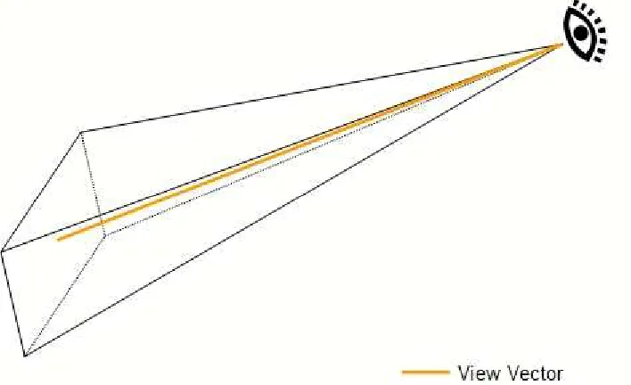
14.2.3 Defining a View ...172
14.2.4 Order of Rotation...174
xii Copyright © 2007, 2008 Open Geospatial Consortium, Inc. All Rights Reserved.
14.3 kml:LookAt ...179
14.3.1 Structure ...179
14.3.2 Description...179
14.3.3 Defining How to Look...180
Copyright © 2007, 2008 Open Geospatial Consortium, Inc. All Rights Reserved. xiii
16.11 kml:displayModeEnumType ...191
16.11.1 Content...191
16.12 kml:gridOriginEnumType ...192
16.12.1 Content...192
16.13 kml:itemIconStateEnumType...192
16.13.1 Description...192
16.13.2 Content...192
16.14 kml:itemIconStateType ...192
16.14.1 Content...192
16.15 kml:listItemTypeEnumType...192
16.15.1 Description...192
16.15.2 Content...193
16.16 kml:refreshModeEnumType ...193
16.16.1 Content...193
16.17 kml:shapeEnumType...193
16.17.1 Content...193
16.18 kml:styleStateEnumType ...194
16.18.1 Content...194
16.19 kml:SnippetType...194
16.19.1 Content...194
16.19.2 Attributes ...194
16.20 kml:unitsEnumType ...194
16.20.1 Description...194
16.20.2 Content...194
16.21 kml:vec2Type ...195
16.21.1 Structure ...195
16.21.2 Description...195
16.21.3 Attributes ...195
16.22 kml:viewRefreshModeEnumType...196
16.22.1 Content...196
Annex A (normative) KML Schemas...197
Annex B (normative) KML Coordinate Reference System Definition ...231
xiv Copyright © 2007, 2008 Open Geospatial Consortium, Inc. All Rights Reserved.
i.
Preface
This is an OGC® Standard for encoding representations of geographic data for display in an earth browser.
Suggested additions, changes, and comments on this draft report are welcome and encouraged. Such suggestions may be submitted by email message or by making suggested changes in an edited copy of this document.
ii.
Submitting organizations
The following organizations submitted this Standard to the Open Geospatial Consortium Inc.:
a) Google, Inc.
b) Galdos Systems Inc.
iii.
Submission contact points
All questions regarding this submission should be directed to the editor or submitters:
CONTACT COMPANY EMAIL
Tim Wilson Galdos Systems Inc. twilson at galdosinc.com
David Burggraf Galdos Systems Inc. dburggraf at galdosinc.com
Ron Lake Galdos Systems Inc. rlake at galdosinc.com
Susan Patch Galdos Systems Inc. spatch at galdosinc.com
Richard Martell Galdos Systems Inc. rmartell at galdosinc.com
Brian McClendon Google, Inc. bam at google.com
Michael Jones Google, Inc. mtj at google.com
Michael Ashbridge Google, Inc. mashbridge at google.com
Bent Hagemark Google, Inc. bent at google.com
Josie Wernecke Google, Inc. josiew at google.com
Carl Reed Open Geospatial
Consortium
Copyright © 2007, 2008 Open Geospatial Consortium, Inc. All Rights Reserved. xv
iv.
Revision history
Date Release Author Paragraph modified
Description
3-7-06 0.0.5 Carl Reed New Initial Version
4/17/07 0.0.9 Carl Reed Various Updates based on comments received during Mass Market GEO WG meeting as well as a request from Google to remove 3 elements.
5/2/07 0.0.9 Carl Reed Various Add preamble and edit document for posting as a BP.
8/1/07 0.0.10 Susan Patch Various Corrected all links to target within the document
Modified text to include final Google KML 2.2 reference text.
8/29/07 0.0.11 Tim Wilson Various Modified text to describe KML in terms of generic earth browsers.
Updated text and terminology to OGC 06-135r1 standards.
8/29/07 0.0.12 David Burggraf Added Section 6, Annex A and various other edits.
Added informative text describing the KML coordinate reference system (CRS) and geometry models in terms of the GML Geometry and Topic 2 (Spatial Referencing). Added GML CRS dictionary to Annex A.
Note: Document number changed to 07-113 when submitted to OGC.
9/6/07 0.0.13 David Burggraf,
Ron Lake, Tim Wilson, Susan Patch
Various Modified text for clarity and consistency and to further describe KML in terms of generic earth browsers.
New diagrams added to Section 6.
9/10/07 0.0.14 Carl Reed OGC terminology Adjusted OGC terminology for new OGC (TBD) policies.
9/11/07 0.0.14 Bent Hagemark,
Michael Ashbridge
All Reviewed for errors and omissions.
9/12/07 0.0.14 David Burggraf Section 6, geometry
9/14/07 0.0.14 Susan Patch All Copy editing and application of OGC styles.
9/14/07 0.0.14 Tim Wilson All Corrected errors and improved
terminology.
xvi Copyright © 2007, 2008 Open Geospatial Consortium, Inc. All Rights Reserved. Date Release Author Paragraph
modified
Description
10/29/07 0.0.15 Tim Wilson, Susan Patch
All Updated structure sections for revised KML 2.2. schema
10/29/07 0.0.15 Bent Hagemark, Richard Martell, Jeremy Parr-Pearson, Tim Wilson
All Update assertions corresponding to OGC 07-134 KML 2.2 – Abstract Test Suite
10/29/07 0.0.15 Bent Hagemark, Michael Ashbridge, Josie Wernecke
PhotoOverlay, ImagePyramid
Text on handling and building large image pyramids.
11/02/07 0.0.15 David Burggraf Section 6, PhotoOverlay
Clarifications.
11/03/07 0.0.15 Tim Wilson Section 6 Extension mechanism and policy text.
11/04/07 0.0.15 Tim Wilson All General edit.
21/01/08 2.2.0-rc1 Tim Wilson Metadata Updated OGC document metadata for Candidate Standard release.
21/01/08 2.2.0-rc1 Tim Wilson Annex A Deprecated Metadata and Url elements maintained in OGC KML 2.2 schema for compatibility with Google KML 2.2 schema. Deprecation note added to all deprecated elements as
xsd:annotation/xsd:documentation.
23/01/08 2.2.0-rc1 Tim Wilson All Copy edit; atom-author-link.xsd
schema/version value changed to "1.0.0".
14/04/08 2.2.0 Tim Wilson All Updated OGC document metadata for
Standard release. Minor errors corrected.
v.
Changes to the OGC® Abstract Specification
Copyright © 2007, 2008 Open Geospatial Consortium, Inc. All Rights Reserved. xvii
Foreword
Attention is drawn to the possibility that some of the elements of this document may be the subject of patent rights. The Open Geospatial Consortium Inc. shall not be held responsible for identifying any or all such patent rights.
xviii Copyright © 2007, 2008 Open Geospatial Consortium, Inc. All Rights Reserved.
Introduction
KML is an XML grammar used to encode and transport representations of geographic data for display in an earth browser. Put simply: KML encodes what to show in an earth browser, and how to show it. KML uses a tag-based structure with nested elements and attributes and is based on the XML standard.
The KML community is wide and varied. Casual users create KML Placemarks to identify their homes, describe journeys, and plan cross-country hikes and cycling ventures. Scientists use KML to provide detailed mappings of resources, models, and trends such as volcanic eruptions, weather patterns, earthquake activity, and mineral deposits. Real estate professionals, architects, and city development agencies use KML to propose construction and visualize plans. Students and teachers use KML to explore people, places, and events, both historic and current. Organizations such as National Geographic, UNESCO, and the Smithsonian have all used KML to display their rich sets of global data.
Copyright © 2007, 2008 Open Geospatial Consortium, Inc. All Rights Reserved. 1
OGC® KML
1 Scope
KML is an XML grammar used to encode and transport representations of geographic data for display in an earth browser, such as a 3D virtual globe, 2D web browser application, or 2D mobile application. A KML instance is processed in much the same way that HTML (and XML) documents are processed by web browsers. Like HTML, KML has a tag-based structure with names and attributes used for specific display purposes.
KML can be used to:
• Annotate the Earth
• Specify icons and labels to identify locations on the surface of the planet
• Create different camera positions to define unique views for KML features
• Define image overlays to attach to the ground or screen
• Define styles to specify KML feature appearance
• Write HTML descriptions of KML features, including hyperlinks and embedded images
• Organize KML features into hierarchies
• Locate and update retrieved KML documents from local or remote network locations
2 Copyright © 2007, 2008 Open Geospatial Consortium, Inc. All Rights Reserved.
2 Conformance
2.1 Conformance requirements
A KML resource that conforms to this standard shall: a) satisfy all requirements stipulated in this document;
b) be well-formed (as defined in the W3C XML 1.0 standard);
c) pass all relevant test cases specified by the Abstract Test Suite (ATS) provided in OGC document 07-134r2.
2.2 Application Profiles
2.2.1 Introduction
An application profile defines a set of elements derived from one or more base standards for the purpose of:
• promoting interoperability; and
• meeting the requirements of a particular application domain.
2.2.2 Rules for Authoring KML Application Profiles
A KML profile can restrict or extend KML to the extent permitted by this standard. The KML schema provides a number of extension points that may be exploited in a profile. While a profile shall not contradict the standard, it may restrict the choice of options or introduce new elements (or do both).
Documents that conform to the KML standard may contain elements and attributes that are not part of the standard but are defined in an application profile. Such elements and
attributes—called foreign information items—must not reside within the KML namespace; they shall be placed in another namespace.
Application profiles shall not redefine any KML components (structurally or semantically) within the KML namespace.
Application profiles which extend KML shall:
Copyright © 2007, 2008 Open Geospatial Consortium, Inc. All Rights Reserved. 3
• add new elements to existing concrete KML elements by substitution only, where permitted by the KML schema;
• derive any new complex types of complex content directly or indirectly by extension from kml:AbstractObjectType;
• derive any new complex types of complex content by extension from the relevant KML abstract type whose semantics it shares.
EXAMPLE: a new feature type shall derive from kml:AbstractFeatureType.
• declare any new elements and attributes as optional, i.e. minOccurs="0", to support the KML update mechanism. This however does not preclude asserting minimum
occurrence constraints as conformance rules within supplementary normative application profile documentation.
Application profiles that extend KML should:
• place any extension elements and attributes in a "vendor-neutral" namespace to support any future potential integration with the KML standard, and encourage interoperability in general.
An adopted OGC application profile that extends KML should:
• be based on a source mass market application profile that is supported by running code;
• preferably maintain or else deprecate the namespace of a source application profile from which it derives, if/where the source profile is in popular use within the mass market. This is to ensure backwards compatibility with existing instances and consumers of the source profile;
• provide a structural and semantic mapping between any profile components which have changed from their original source profile.
Authors of application profiles are encouraged to submit their extensions to OGC for standardization. This does not preclude any resulting OGC application profile from being merged later into the KML standard.
3 Normative references
4 Copyright © 2007, 2008 Open Geospatial Consortium, Inc. All Rights Reserved.
of applying the most recent editions of the normative documents indicated below. For undated references, the latest edition of the normative document referred to applies. OGC 07-134r2, OGC KML 2.2 - Abstract Test Suite
IETF RFC 4287, Atom Syndication F
OASIS Extensible Address Language (XAL) 2.0. Available from:
IETF RFC 3966, The tel URI for Telephone Numbers. Available from:
ISO 8601:2004, Data elements and interchange formats — Information interchange — Representation of dates and times
IETF RFC 3986, Uniform Resource Identifier (URI): Generic Syntax. Available from:
W3C XHTML 1.0, The Extensible HyperText Markup Language. Available from:
W3C Extensible Markup Language (XML) 1.0. Available from: http://www.w3.org/TR/REC-xml/
W3C Namespaces in XML 1.0. Available from: http://www.w3.org/TR/REC-xml-names/
W3C XML Schema Part 1: St
W3C XML Schema Part 2: Datatypes. Available from: http://www.w3.org/TR/xmlschema-2/
4 Terms and symbols
4.1 Terms and definitions
For the purposes of this document, the following terms and definitions apply.
4.1.1
application schema
Copyright © 2007, 2008 Open Geospatial Consortium, Inc. All Rights Reserved. 5
4.1.2
attribute <XML>
name/value pair contained in an element
NOTE: In this document an attribute is an XML attribute unless otherwise specified
4.1.3
boundary
set that represents the limit of an entity [ISO 19107]
4.1.4
bounding box
minimum volume that encloses a set of objects or data points.
4.1.5
child element <XML>
immediate descendant element
4.1.6
complex element <XML>
element of complex content
4.1.7
coordinate
one of a sequence of n numbers designating the position of a point in n-dimensional space [ISO 19111]
NOTE: In a coordinate reference system, the n numbers shall be qualified by units.
4.1.8
coordinate reference system
6 Copyright © 2007, 2008 Open Geospatial Consortium, Inc. All Rights Reserved.
4.1.9
coordinate system
set of mathematical rules for specifying how coordinates are to be assigned to points [ISO 19111]
4.1.10
coordinate tuple
tuple composed of a sequence of coordinates [ISO 19111]
4.1.11
data type
specification of a value domain with operations allowed on values in this domain [ISO/TS 19103]
EXAMPLE: integer, real, boolean, string, date (conversion of a data into a series of codes).
NOTE: Data types include primitive predefined types and user-definable types. All instances of a data types lack identity.
4.1.12
datum
parameter or set of parameters that define the position of the origin, the scale, and the orientation of a coordinate system
[ISO 19111]
NOTE: A datum may be a geodetic datum, a vertical datum, an engineering datum, an image datum or a temporal datum.
4.1.13
document <XML>
well-formed XML instance
4.1.14
earth browser
Copyright © 2007, 2008 Open Geospatial Consortium, Inc. All Rights Reserved. 7
4.1.15
element <XML>
basic information item of an XML document containing child elements, attributes and character data
NOTE: From the XML Information Set: "Each XML document contains one or more elements, the boundaries of which are either delimited by start-tags and end-tags, or, for empty elements, by an empty-element tag. Each element has a type, identified by name, sometimes called its 'generic identifier' (GI), and may have a set of attribute specifications. Each attribute specification has a name and a value."
4.1.16
field
child element of simple content
4.1.17
field type
XML Schema simple type defined in the KML schema document
4.1.18
geodetic datum
datum describing the relationship of a 2- or 3-dimensional coordinate system to the Earth [ISO 19111]
4.1.19
geographic view
display of geographic KML elements
4.1.20
interior
set of all points that are on a geometric object but which are not on its boundary
4.1.21
line string
curve composed of straight-line segments
4.1.22
list view
8 Copyright © 2007, 2008 Open Geospatial Consortium, Inc. All Rights Reserved.
4.1.23
namespace <XML>
collection of names, identified by a URI reference, which are used in XML documents as element names and attribute names [W3C XML Namespaces]
4.1.24
plate carrée projection
A simple cylindrical projection in which the target plane has a horizontal axis representing longitude (standard parallel is the Equator) and vertical axis representing latitude. Otherwise known as equi-rectangular, plane chart, or unprojected map projection.
4.1.25
point
0-dimensional geometric primitive, representing a position [ISO 19107]
NOTE: The boundary of a point is the empty set.
4.1.26
polygon
planar surface defined by 1 exterior boundary and 0 or more interior boundaries
4.1.27
resource
network data object or service that is identified by a URL
4.1.28
schema
formal description of a model [ISO 19101]
NOTE: In general, a schema is an abstract representation of an object's characteristics and relationship to other objects. An XML schema represents the relationship between the attributes and elements of an XML object (for example, a document or a portion of a document)
4.1.29
schema <XML Schema>
collection of schema components within the same target namespace
Copyright © 2007, 2008 Open Geospatial Consortium, Inc. All Rights Reserved. 9
4.1.30
schema document <XML Schema>
XML document containing schema component definitions and declarations
NOTE: The W3C XML Schema provides an XML interchange format for schema information. A single schema document provides descriptions of components associated with a single XML namespace, but several documents may describe components in the same schema, i.e. the same target
namespace.
4.1.31
simple element <XML>
element of simple content
4.1.32
tag <XML>
markup in an XML document delimiting the content of an element
NOTE: A tag with no forward slash (e.g. <Placemark> ) is called a start-tag (also opening tag), and one with a forward slash (e.g. </Placemark> is called an end-tag (also closing tag).
4.1.33
tuple
ordered list of values
4.1.34
Uniform Resource Identifier (URI)
unique identifier for a resource, structured in conformance with IETF RFC 2396
NOTE: The general syntax is <scheme>::<scheme-specific-part>. The hierarchical syntax with a namespace is <scheme>://<authority><path>?<query> – see [RFC 2396].
4.2 Acronyms (and abbreviated terms)
Some frequently used abbreviated terms: COTS Commercial Off The Shelf
CRS Coordinate Reference System
CS Coordinate System
CSV Comma Separated Values
10 Copyright © 2007, 2008 Open Geospatial Consortium, Inc. All Rights Reserved.
DTD Document Type Definition
EPSG European Petroleum Survey Group
GIS Geographic Information System
GML Geography Markup Language
NOTE: The acronym GML was previously used in ISO also as Generalized Markup Language (which led to SGML Standard Generalized Markup Language, ISO 8879).
HTTP Hypertext Transfer Protocol
IETF Internet Engineering Task Force
ISO International Organization for Standardization
KMZ KML Archive File
OGC Open Geospatial Consortium
RFC Request for Comments
URI Uniform Resource Identifier
URL Uniform Resource Locator
URN Uniform Resource Name
W3C World Wide Web Consortium
xAL eXtensible Address Language
XML eXtended Markup Language
XSD XML Schema Definition
0D Zero Dimensional
1D One Dimensional
2D Two Dimensional
Copyright © 2007, 2008 Open Geospatial Consortium, Inc. All Rights Reserved. 11 5 Conventions
5.1 UML Notation
There is no UML associated with this Standard.
5.2 XML Namespaces
All components of the KML schema are defined in the namespace with the identifier
"http://www.opengis.net/kml/2.2", for which the prefix kml or the default namespace is used within this Standard.
The atom:author and atom:link components described by the Atom Syndication Format are defined in the namespace with the identifier "http://www.w3.org/2005/Atom", for
which the prefix atom is used within this Standard.
NOTE The schema components from these namespaces are documented in the XML Schema documents found in Annex A.
The xAL:AddressDetails component described by the eXtensible Address Language is
defined in the namespace with the identifier
"urn:oasis:names:tc:ciq:xsdschema:xAL:2.0", for which the prefix xAL is used within this OGC® Standard.
5.3 XML Schema
KML uses the W3C XML Schema language to describe the grammar of conformant KML data instances. The KML schema document is included in Annex A and forms a normative part of this OGC® Standard.
The normative KML schema includes deprecated schema components that KML producers are advised to not use; they may be removed in a subsequent major revision.
5.4 Versioning
12 Copyright © 2007, 2008 Open Geospatial Consortium, Inc. All Rights Reserved.
Major revisions shall maintain the highest level of achievable backwards compatibility to a previous release, except for any change in the version namespace.
5.5 Deprecated parts of previous versions of KML
The verb "deprecate" provides notice that the referenced portion of this Standard is being retained for backwards compatibility with earlier versions but may be removed from a subsequent major revision.
5.6 Documentation
Clauses 7 to 15 specify the content model for each KML element. The KML content model is defined in terms of child elements and attributes. Where a child element is defined in a separate subclause, a link is provided to it.
Throughout this document, the following conventions are used:
• Concrete element and attribute names used within the text are formatted in Courier New and abstract elements in Courier New Italic, except in the case of headings and references to them.
• A value from an enumerated set is in bold.
• Child element content is specified within the element subclause whose type declares such children.
• The prefix "xsd:" is used to identify types that are defined by XML Schema, for example xsd:string.
• The use of abstract substitution elements within the text refers to the concrete elements that substitute for them. For example, kml:AbstractContainerGroup refers to the kml:Document and kml:Folder elements that substitute for it. Element substitution is described for each element where applicable.
• The term kml:Document is a KML element; the term "KML document" refers to an XML instance of KML.
• Default values for simple elements are listed under relevant Content subclauses. Unless otherwise stated, default values for optional elements shall apply when such elements are empty or absent.
Copyright © 2007, 2008 Open Geospatial Consortium, Inc. All Rights Reserved. 13
Each element subclause includes a XML structure section that shows the content model for the described element as a representative XML instance, using the following conventions:
• The minimum and maximum occurrence of elements and attributes required by its schema type are shown in square brackets, for example [0..1]. Such occurrence requirements are necessary but insufficient in that additional occurrence requirements are asserted within this OGC® Standard.
• Elements are listed in the required document order.
• Choice model group information is represented by "Start Choice ... End Choice".
• Where the type for an element derives by extension from a base type, the elements and attributes that have been added to the base type's content are shown in bold.
6 KML Model Overview
6.1 KML Architecture
This section provides an overview of the KML schema type hierarchy. While element names are used, they represent the schema types that define their content. As KML is an XML grammar, element names are case-sensitive and must appear exactly as specified in the KML schema document.
In KML, some types are derived from a parent type. A derived type inherits all of the
elements of its parent type and may add some specific element content of its own. KML also includes abstract elements whose type is also abstract. Such abstract types are used to
establish schema type hierarchies. Abstract elements may serve as placeholders for elements that substitute for them in the XML Schema sense.
The core KML type hierarchy is represented in the following nested list. It shows the abstract KML elements that serve as the head of a substitution group for its corresponding type (in brackets). The abstract elements themselves follow an identical substitution hierarchy. For example, kml:AbstractContainerGroup substitutes for
kml:AbstractFeatureGroup, which in turn substitutes for kml:AbstractObjectGroup. • kml:AbstractObjectGroup (kml:AbstractObjectType)
• kml:AbstractFeatureGroup (kml:AbstractFeatureType)
• AbstractContainerGroup (kml:AbstractContainerType)
• AbstractOverlayGroup (kml:AbstractOverlayType)
14 Copyright © 2007, 2008 Open Geospatial Consortium, Inc. All Rights Reserved. • AbstractStyleSelectorGroup (kml:AbstractStyleSelectorType)
• AbstractSubStyleGroup (kml:AbstractSubStyleType)
• AbstractColorStyleGroup (kml:AbstractColorStyleType)
• AbstractLatLonBox (kml:AbstractLatLonBoxType)
• AbstractViewGroup (kml: AbstractViewType)
• AbstractTimePrimitiveGroup (kml:AbstractTimePrimitiveType)
These abstract elements and their associated base types define the core of the language. All concrete elements derived from kml:AbstractObjectGroup may have an assigned identifier.
Simple elements are generally referred to as KML fields. Such elements are of XML Schema simple types or KML field types defined in the KML schema. KML field types are specified in clause 16 Field Types.
6.2 Coordinate Reference System
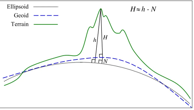
Each element that extends the kml:AbstractGeometryGroup element defines a spatial extent of a kml:Placemark. The spatial extent may include the location of an anchor point on the earth to serve as an origin for a 3D object as in the case of the kml:Model element, or may include the encoding of explicit coordinate tuples in the kml:coordinates element in the case of the kml:Point, kml:LineString, and kml:LinearRing elements.
Copyright © 2007, 2008 Open Geospatial Consortium, Inc. All Rights Reserved. 15 Ellipsoid
Geoid Terrain
H≈h - N
h H
N
Figure 1: Altitude H is Measured from the Vertical Datum (Geoid) and is Compared to the Ellipsoid Height h and the Geoid Undulation N.
6.3 Geometry Interpolation for 3D Earth Browsers
6.3.1 Interpolated Points
Geometric points which are not explicitly encoded are called interpolated points. The following subclauses describe the interpolation schemes for the kml:LineString,
kml:LinearRing, and kml:Polygon elements. 6.3.2 kml:LineString and kml:LinearRing
The type of interpolation used for the kml:LineString and kml:LinearRing elements depend on the values of the child kml:altitudeMode and kml:tessellate elements. If the
kml:altitudeMode value is not clampToGround then the interpolation between two
consecutive control points is a straight line segment in the 3D WGS 84 geocentric coordinate reference system (urn:x-ogc:def:crs:EPSG:6.12:4978). This straight line segment will be referred to as L in Table 1, which summarizes the kml:LineString and kml:LinearRing
interpolation scheme for the various combinations of kml:altitudeMode and kml:tessellate values.
Table 1: Interpolation scheme for kml:LineString and kml:LinearRing
<altitudeMode> <tessellate> Interpolation between control points
relativeToGround or absolute
0 (false) or 1 (true)
16 Copyright © 2007, 2008 Open Geospatial Consortium, Inc. All Rights Reserved.
<altitudeMode> <tessellate> Interpolation between control points
clampToGround 1 (true) Project each point of L to the terrain surface along a line through the earth's center of mass
clampToGround 0 (false) First project each control point to the terrain surface along a line through the earth's center of mass, then interpolate between the
projected control points along a straight line segment in the 3D WGS 84 geocentric coordinate reference system
(urn:x-ogc:def:crs:EPSG:6.12:4978)
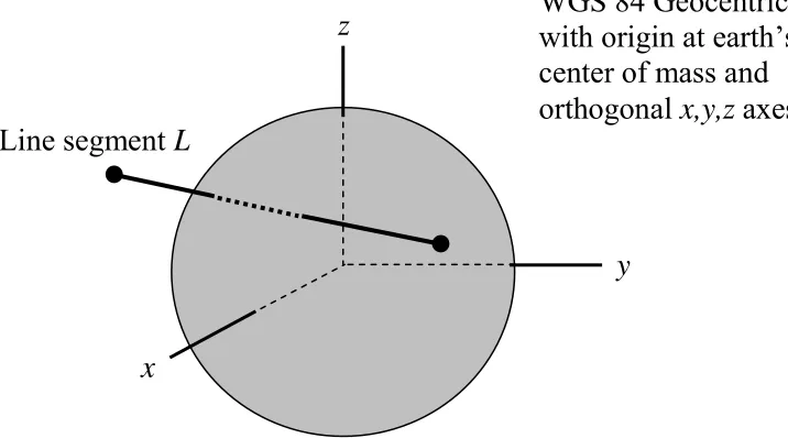
For example, in the following KML instance the kml:LineString coordinates element has two control points (–135,30,500000) and (–80,30,500000) of the form (long,lat,altitude) in the CRS defined in with gml:id="LonLat84_5773".
<kml xmlns="http://www.opengis.net/kml/2.2"> <Document>
<Placemark> <LineString>
<altitudeMode>absolute</altitudeMode>
<coordinates>-135,30,500000 -80,30,500000</coordinates> </LineString>
</Placemark> </Document> </kml>
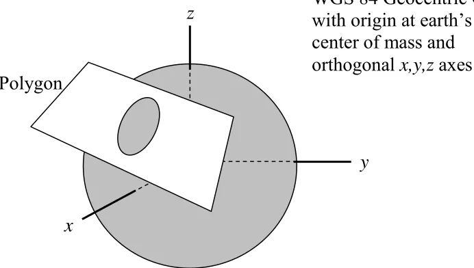
Since the kml:altitudeMode is absolute, the interpolation between these two control points is the straight line segment L shown in Figure 2 in the 3D WGS 84 geocentric CRS, which does not follow the earth's curvature and cuts through the earth's terrain.
x
y
z
WGS 84 Geocentric CRS
with origin at earth’s
center of mass and
orthogonal
x,y,z
axes
Line segment
L
Copyright © 2007, 2008 Open Geospatial Consortium, Inc. All Rights Reserved. 17
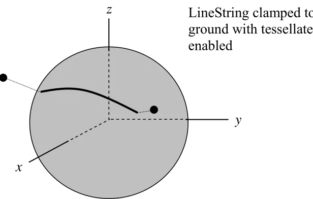
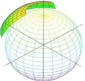
The line segment L will be projected to the terrain surface if kml:altitudeMode and
kml:tessellate are set as in the following kml:LineString instance. In this case the projected kml:LineString will follow the earth's curvature as shown in Figure 3
<kml xmlns="http://www.opengis.net/kml/2.2"> <Document>
<Placemark> <LineString>
<tessellate>true</tessellate>
<altitudeMode>clampToGround</altitudeMode>
<coordinates>-135,30,500000 -80,30,500000</coordinates> </LineString>
</Placemark> </Document> </kml>
x
y
z
LineString clamped to
ground with tessellate
enabled
18 Copyright © 2007, 2008 Open Geospatial Consortium, Inc. All Rights Reserved.
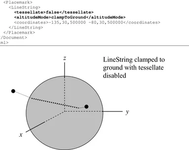
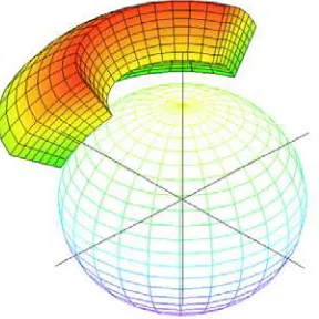
If kml:altitudeMode and kml:tessellate are set as in the following kml:LineString
instance, then the only the control points are projected to the terrain and the interpolalation between the projected control points is a straight line segment in the WGS 84 Geocentric CRS as shown in Figure 4.
<kml xmlns="http://www.opengis.net/kml/2.2"> <Document>
<Placemark> <LineString>
<tessellate>false</tessellate>
<altitudeMode>clampToGround</altitudeMode>
<coordinates>-135,30,500000 -80,30,500000</coordinates> </LineString>
</Placemark> </Document> </kml>
x
y
z
LineString clamped to
ground with tessellate
disabled
Figure 4: A Line Segment Interpolated in the WGS 84 Geocentric CRS
6.3.3 kml:Polygon
The type of interpolation used for the kml:Polygon element also depends on the values of the child kml:altitudeMode and kml:tessellate elements. If the kml:altitudeMode
value is not clampToGround then the interpolation of the kml:Polygon boundary
comprised of the descendent kml:LinearRing elements is as described previously in Table 1. The remaining interior points of the kml:Polygon are then filled in linearly in the 3D
WGS 84 geocentric CRS, i.e. they must lie on the plane that passes through all the control points of each kml:LinearRing.
Copyright © 2007, 2008 Open Geospatial Consortium, Inc. All Rights Reserved. 19
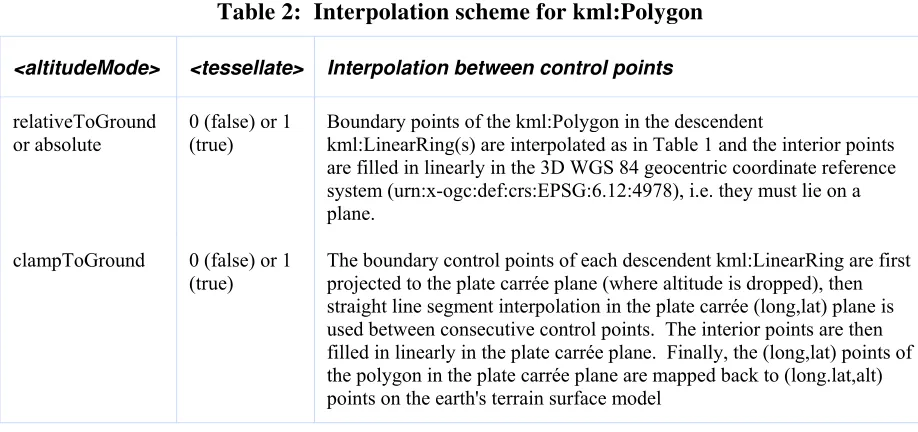
Table 2 summarizes the kml:Polygon interpolation scheme for the various combination of
kml:altitudeMode and kml:tessellate values.
Table 2: Interpolation scheme for kml:Polygon
<altitudeMode> <tessellate> Interpolation between control points
relativeToGround or absolute
0 (false) or 1 (true)
Boundary points of the kml:Polygon in the descendent
kml:LinearRing(s) are interpolated as in Table 1 and the interior points are filled in linearly in the 3D WGS 84 geocentric coordinate reference system (urn:x-ogc:def:crs:EPSG:6.12:4978), i.e. they must lie on a plane.
clampToGround 0 (false) or 1 (true)
The boundary control points of each descendent kml:LinearRing are first projected to the plate carrée plane (where altitude is dropped), then straight line segment interpolation in the plate carrée (long,lat) plane is used between consecutive control points. The interior points are then filled in linearly in the plate carrée plane. Finally, the (long,lat) points of the polygon in the plate carrée plane are mapped back to (long.lat,alt) points on the earth's terrain surface model
20 Copyright © 2007, 2008 Open Geospatial Consortium, Inc. All Rights Reserved.
<kml xmlns="http://www.opengis.net/kml/2.2"> <Document>
<Placemark> <Polygon>
<altitudeMode>absolute</altitudeMode>
<outerBoundaryIs> <LinearRing> <coordinates>
-135,50,300000 -135,40,450000 -80,40,450000 -80,50,300000 -135,50,300000 </coordinates>
</LinearRing> </outerBoundaryIs> </Polygon>
</Placemark> </Document> </kml>
Since the kml:altitudeMode is absolute, the outer boundary points of the polygon that are interpolated between the control points in the kml:LinearRing form a quadrilateral
perimeter in the 3D WGS 84 geocentric CRS. The interior points of this 4 sided polygon are filled in linearly in the 3D WGS 84 geocentric CRS and form the plane region inside the perimeter. Note that the plane region does not follow the earth's curvature and cuts through the surface of the earth as shown in Figure 5.
x
y
z
WGS 84 Geocentric CRS
with origin at earth’s
center of mass and
orthogonal
x,y,z
axes
Polygon
Copyright © 2007, 2008 Open Geospatial Consortium, Inc. All Rights Reserved. 21
In the following kml:Polygon instance the kml:altitudeMode is set to clampToGround. <kml xmlns="http://www.opengis.net/kml/2.2">
<Document> <Placemark> <Polygon>
<altitudeMode>clampToGround</altitudeMode>
<outerBoundaryIs> <LinearRing>
<coordinates>135,78.5,300000 135,12.5,300000 45,12.5,300000 -45,78.5,300000 -135,78.5,300000</coordinates>
</LinearRing> </outerBoundaryIs> </Polygon>
</Placemark> </Document> </kml>
The outer boundary points of the polygon that are interpolated between the control points in the kml:LinearRing form a rectangular perimeter in the plate carrée plane. Then the interior points of the rectangle are filled in linearly in this plane. Finally each (long,lat) point of the rectangle is mapped to a (long,lat,alt) point on the earth terrain surface as shown in Figure 6.
Figure 6: KML Polygon Interpolation in the Plate Carrée Plane
6.3.4 kml:GroundOverlay and kml:Region
The latitude and longitude boundaries for both kml:GroundOverlay and kml:Region are
specified by the elements kml:west, kml:east, kml:south, and kml:north. In the case of
kml:GroundOverlay constant lines of longitude demarcate the portion of the
kml:LatLonBox boundary corresponding to the values of kml:west, kml:east and constant
lines of latitude demarcate the portion of the boundary corresponding to the values of
22 Copyright © 2007, 2008 Open Geospatial Consortium, Inc. All Rights Reserved.
following KML example, then the altitude of the kml:GroundOverlay is determined by the
kml:altitude element. <kml>
<GroundOverlay>
<altitude>500000</altitude>
<altitudeMode>absolute</altitudeMode> <LatLonBox>
<north>80.0</north> <south>60.0</south> <east>60.0</east> <west>-60.0</west> </LatLonBox>
</GroundOverlay> </kml>
The KML example above is shown in Figure 7. If kml:altitudeMode value is
clampToGround then the kml:GroundOverlay is projected onto the earth's terrain surface model similar to the case of the kml:Polygon shown on the right hand side of Figure 6.
Figure 7: KML GroundOverlay when value of kml:altitudeMode is not clampToGround
In the case of kml:Region the values of kml:west, kml:east of kml:LatLonAltBox
determine the boundary surfaces of constant longitude and the values of kml:south, kml:north determine the boundary surfaces of constant latitude. The values of
Copyright © 2007, 2008 Open Geospatial Consortium, Inc. All Rights Reserved. 23
<kml> <Region>
<LatLonAltBox>
<north>80.0</north> <south>60.0</south> <east>60.0</east> <west>-60.0</west>
<minAltitude>500000</minAltitude> <maxAltitude>2000000</maxAltitude> <altitudeMode>absolute</altitudeMode> </LatLonAltBox>
</Region> </kml>
The spatial extent of the sample kml:Region encoded above is depicted in Figure 8.
Figure 8: KML Region when value of kml:altitudeMode is not clampToGround
6.4 Shared Styles
A kml:Style or kml:StyleMap element contained by a kml:AbstractFeatureGroup
element is an "inline style" and shall apply only to the kml:AbstractFeatureGroup that contains it. When these elements are encoded as the child of a kml:Document element they
are called a "shared style." A shared style shall have an id value. A shared style applies to any kml:AbstractFeatureGroup that references the style from its child kml:styleUrl
element.
If a kml:AbstractFeatureGroup is associated with both an inline and shared style, the inline style shall take precedence.
Shared styles shall only be encoded within a Document. Shared styles are not inherited by any child kml:AbstractFeatureGroup elements of a kml:Document.
24 Copyright © 2007, 2008 Open Geospatial Consortium, Inc. All Rights Reserved.
<Document>
<Style id="myPrettyDocument"> <ListStyle> ... </ListStyle>
</Style>
<styleUrl#myPrettyDocument"> ...
</Document>
The following example illustrates the use of a shared style. <kml xmlns="http://www.opengis.net/kml/2.2">
<Document>
<name>Document.kml</name> <open>1</open>
<Style id="exampleStyleDocument">
<LabelStyle>
<color>ff0000cc</color> </LabelStyle>
</Style>
<Placemark>
<name>Document Feature 1</name>
<styleUrl>#exampleStyleDocument</styleUrl>
<Point>
<coordinates>-122.371,37.816,0</coordinates> </Point>
</Placemark> <Placemark>
<name>Document Feature 2</name>
<styleUrl>#exampleStyleDocument</styleUrl>
<Point>
<coordinates>-122.370,37.817,0</coordinates> </Point>
</Placemark>
</Document>
</kml>
6.5 Entity Replacement
Entity substitution is employed as a template mechanism within the kml:BalloonStyle kml:text element. Individual values shall be substituted for each instance of the entity, or a
null string if no value exists. The source of values for entity substitution is local to the
kml:AbstractFeatureGroup being styled and any kml:Schema elements associated with it. Entity syntax for identifying a substitution value is as follows:
1. $[element_or_attribute_name], where "element_or_attribute_name" is the name of a field element or attribute of the kml:AbstractFeatureGroup. This identifies the value of the field element or attribute.
2. $[name_attribute_of_Data_element], where
"name_attribute_of_Data_element" is the value of the kml:name attribute of a
Copyright © 2007, 2008 Open Geospatial Consortium, Inc. All Rights Reserved. 25
3. $[name_attribute_of_Data_element/displayName], where
"name_attribute_of_Data_element" is the value of the kml:name attribute of a
descendant kml:Data element of the kml:AbstractFeatureGroup; "/" is a separator; and "displayName" is the value of the kml:displayName attribute of the kml:Data element. This identifies the value of the kml:displayName
attribute.
4. $[TYPENAME/TYPEFIELD], where "TYPENAME" is the value of the
kml:name attribute of a descendant kml:Schema element of the
kml:AbstractFeatureGroup; "/" is a separator; and "TYPEFIELD" is the value
of the kml:name attribute of a child kml:SimpleField element of the
kml:Schema element . This identifies the value of a descendant kml:SimpleData
element of the kml:AbstractFeatureGroup that references the kml:SimpleField element.
5. $[TYPENAME/TYPEFIELD/displayName], where "TYPENAME" is the value of the kml:name attribute of a descendant kml:Schema element of the
kml:AbstractFeatureGroup; "/" is a separator; and "TYPEFIELD" is the value of the kml:name attribute of a child kml:SimpleField element of the
kml:Schema element; and "displayName" is the value of the child
kml:displayName element of the kml:SimpleField element. This identifies the value of the kml:displayName element.
For example, the $[name] and $[description] entities in the following kml:BalloonStyle kml:text element shall be replaced by the kml:name and kml:description values of
kml:AbstractFeatureGroup elements associated with the kml:BalloonStyle: <text>This is $[name], whose description is:<br/>$[description]</text>
6.6 Extension Model
6.6.1 Introduction
The KML schema provides several mechanisms to extend KML within application profiles. All KML extensions shall conform to the extension profile requirements discussed in 2.2 Application Profiles.
6.6.2 Extension by Inheritance
The KML schema defines abstract base types (e.g. kml:AbstractFeatureType), concrete
26 Copyright © 2007, 2008 Open Geospatial Consortium, Inc. All Rights Reserved.
complex types is prohibited, new schema types may be derived from the core abstract base types (see 6.1).
6.6.3 Extension by Composition
6.6.3.1 Simple Element Substitution
A simple element whose type derives from xsd:anySimpleType may be declared to
substitute for a KML abstract head element whose type is of xsd:anySimpleType. Such head elements have a naming convention whereby their local name ends with
"SimpleExtensionGroup" (e.g. kml:AbstractFeatureSimpleExtensionGroup).
6.6.3.2 Complex Element Substitution
A complex element may substitute for a KML abstract head element that is:
• of a core abstract base type (e.g. kml:AbstractFeatureType).
• of xsd:anyType and substitutes for kml:AbstractObjectGroup. Substituting for such an element requires a type definition that derives from
kml:AbstractObjectGroup. All such head elements have a local name that ends with "ObjectExtensionGroup" (e.g. kml:AbstractFeatureObjectExtensionGroup).
• head elements that are of xsd:anyType and declare no substitution group. These have a local name that ends with "Extension" (e.g. kml:DataExtension).
Usage examples:
• a new element whose type derives by extension from kml:AbstractFeatureType and substitutes for kml:AbstractFeatureGroup would be available wherever
kml:AbstractFeatureGroup is permitted; that is, as a child of kml:Document, kml:Folder, kml:kml or kml:Delete.
• a new element whose type derives by extension from kml:AbstractObjectType and
substitutes for kml:AbstractFeatureObjectExtensionGroup would be available
wherever kml:AbstractFeatureObjectExtensionGroup is permitted; that is, as a child of kml:Document, kml:Folder, kml:GroundOverlay, kml:ScreenOverlay,
kml:PhotoOverlay, kml:Placemark, and kml:NetworkLink.
• a new element whose type is of xsd:anyType and substitutes for kml:DataExtension
Copyright © 2007, 2008 Open Geospatial Consortium, Inc. All Rights Reserved. 27 7 Root Element
7.1 kml
7.1.1 Structure <kml:kml
hint="string [0..1]">
<kml:NetworkLinkControl> ... </kml:NetworkLinkControl> [0..1] <kml:AbstractFeatureGroup> ... </kml:AbstractFeatureGroup> [0..1] <kml:KmlSimpleExtensionGroup> ... </kml:KmlSimpleExtensionGroup> [0..*] <kml:KmlObjectExtensionGroup> ... </kml:KmlObjectExtensionGroup> [0..*] </kml:kml>
7.1.2 Description
The root element of a KML document instance. It should contain at least one of its child elements.
7.1.3 Content
7.1.3.1 kml:NetworkLinkControl
See 13.2 kml:NetworkLinkControl.
7.1.3.2 kml:AbstractFeatureGroup
See 9.1 kml:AbstractFeatureGroup.
7.1.3.3 kml:KmlSimpleExtensionGroup
See 6.6.3.1 Simple Element Substitution.
7.1.3.4 kml:KmlObjectExtensionGroup
28 Copyright © 2007, 2008 Open Geospatial Consortium, Inc. All Rights Reserved. 7.1.4 Attributes
7.1.4.1 hint
7.1.4.1.1 Description
The hint attribute may be used to provide information on how to process the KML document instance.
7.1.4.1.2 Content
Type: xsd:string
Default Value: none
7.1.5 Example
<kml xmlns="http://www.opengis.net/kml/2.2">
<NetworkLinkControl> ... </NetworkLinkControl> <Document> ... </Document>
Copyright © 2007, 2008 Open Geospatial Consortium, Inc. All Rights Reserved. 29 8 Object
8.1 kml:AbstractObjectGroup
8.1.1 Structure
<kml:AbstractObjectGroup id="ID [0..1]"
targetId="NCName [0..1]">
<kml:ObjectSimpleExtensionGroup> ... </kml:ObjectSimpleExtensionGroup> [0..*] </kml:AbstractObjectGroup>
8.1.2 Description
Abstract: yes
The following elements can be used wherever this element is referenced:
• kml:AbstractFeatureGroup • kml:AbstractContainerGroup
• kml:Document • kml:Folder
• kml:AbstractOverlayGroup • kml:GroundOverlay
• kml:ScreenOverlay • kml:PhotoOverlay
• kml:Placemark • kml:NetworkLink
• kml:AbstractViewGroup • kml:LookAt
• kml:Camera • kml:SchemaData
• kml:Data • kml:AbstractGeometryGroup
• kml:MultiGeometry • kml:Point
• kml:LineString • kml:LinearRing
• kml:Polygon • kml:Model
• kml:AbstractStyleSelectorGroup • kml:Style
• kml:StyleMap • kml:AbstractTimePrimitiveGroup
• kml:TimeStamp • kml:TimeSpan
• kml:Region • kml:LatLonAltBox
• kml:Lod • kml:Icon
• kml:Link • kml:Location
• kml:Orientation • kml:Scale
30 Copyright © 2007, 2008 Open Geospatial Consortium, Inc. All Rights Reserved. • kml:AbstractLatLonBox • kml:LatLonBox
• kml:ViewVolume • kml:ImagePyramid
• kml:Pair • kml:AbstractSubStyleGroup
• kml:AbstractColorStyleGroup • kml:IconStyle
• kml:LabelStyle • kml:LineStyle
• kml:PolyStyle • kml:BalloonStyle
• kml:ListStyle • kml:ItemIcon
8.1.3 Attributes
8.1.3.1 id
8.1.3.1.1 Description
The id attribute may be used to specify a unique identifier for the kml:AbstractObjectGroup within the KML document instance.
If a kml:AbstractObjectGroup is not being used for update purposes (not a descendant of kml:Update) and it is empty then it shall have an id attribute. This facilitates updating the
object to include content at a later point in time.
8.1.3.1.2 Content
Type: xsd:ID
Default Value: none
8.1.3.2 targetId
8.1.3.2.1 Description
The optional targetId attribute may be used to encode the id value of another
kml:AbstractObjectGroup.
If a kml:AbstractObjectGroup is being used for update purposes (is a grandchild of kml:Update) then it shall have a targetId attribute referencing the
kml:AbstractObjectGroup element to be updated. Otherwise, outside of an update context
targetId has no meaning.
Copyright © 2007, 2008 Open Geospatial Consortium, Inc. All Rights Reserved. 31
8.1.3.2.2 Content
Type: xsd:NCName
Default Value: none
8.1.3.3 kml:AbstractObjectGroupSimpleExtensionGroup
32 Copyright © 2007, 2008 Open Geospatial Consortium, Inc. All Rights Reserved.
targetId="NCName [0..1]">
<kml:ObjectSimpleExtensionGroup> ... </kml:ObjectSimpleExtensionGroup> [0..*]
<kml:name> ... </kml:name> [0..1]
<kml:visibility> ... </kml:visibility> [0..1] <kml:open> ... </kml:open> [0..1]
<atom:author> ... </atom:author> [0..1] <atom:link> ... </atom:link> [0..1] <kml:address> ... </kml:address> [0..1]
<xal:AddressDetails> ... </xal:AddressDetails> [0..1] <kml:phoneNumber> ... </kml:phoneNumber> [0..1] <kml:snippet> ... </kml:snippet> [0..1]
<kml:description> ... </kml:description> [0..1]
<kml:AbstractViewGroup> ... </kml:AbstractViewGroup> [0..1]
<kml:AbstractTimePrimitiveGroup> ... </kml:AbstractTimePrimitiveGroup> [0..1] <kml:styleUrl> ... </kml:styleUrl> [0..1]
<kml:AbstractStyleSelectorGroup> ... </kml:AbstractStyleSelectorGroup> [0..*] <kml:Region> ... </kml:Region> [0..1]
<kml:ExtendedData> ... </kml:ExtendedData> [0..1] <kml:AbstractFeatureSimpleExtensionGroup> ... </kml:AbstractFeatureSimpleExtensionGroup> [0..*] <kml:AbstractFeatureObjectExtensionGroup> ... </kml:AbstractFeatureObjectExtensionGroup> [0..*]
</kml:AbstractFeatureGroup>
9.1.2 Description
Abstract: yes
This element can be used wherever the following element is referenced:
• kml:AbstractObjectGroup
The following elements can be used wherever this element is referenced:
• kml:AbstractContainerGroup • kml:Document
• kml:Folder • kml:AbstractOverlayGroup
• kml:GroundOverlay • kml:ScreenOverlay
• kml:PhotoOverlay • kml:Placemark
Copyright © 2007, 2008 Open Geospatial Consortium, Inc. All Rights Reserved. 33 9.1.3 Content
9.1.3.1 kml:name
9.1.3.1.1 Description
Specifies a label for the kml:AbstractFeatureGroup.
9.1.3.1.2 Content
Type: xsd:string
Default Value: none
9.1.3.2 kml:visibility
9.1.3.2.1 Description
Specifies whether the kml:AbstractFeatureGroup shall be drawn in the geographic view when it is initially loaded (1 or true), or not (0 or false). In order for a
kml:AbstractFeatureGroup to be visible, the kml:visibility tag of all its ancestors shall also be set to 1 or true.
9.1.3.2.2 Content
Type: xsd:boolean Default Value: 1 or true
9.1.3.3 kml:open
9.1.3.3.1 Description
Specifies whether a kml:AbstractContainerGroup appears expanded (1 or true) or collapsed (0 or false) when first loaded into the list view.
See also 12.13 kml:ListStyle.
9.1.3.3.2 Content
34 Copyright © 2007, 2008 Open Geospatial Consortium, Inc. All Rights Reserved. 9.1.3.4 atom:author
9.1.3.4.1 Description
Specifies the author of the kml:AbstractFeatureGroup.
See also 9.6 kml:AbstractContainerGroup regarding the inheritance of the atom:author
within KML feature hierarchies.
9.1.3.4.2 Content
See IETF RFC 4287, 4.2.1.
9.1.3.5 atom:link
9.1.3.5.1 Description
Specifies the URL of the source resource that contains the kml:AbstractFeatureGroup. The URL is encoded as the value of the atom:href attribute.
The atom:link rel attribute shall be present and its value shall be related.
See also 9.6 kml:AbstractContainerGroup regarding the inheritance of the atom:link within KML feature hierarchies.
9.1.3.5.2 Content
See IETF RFC 4287, 4.2.7.
9.1.3.6 kml:address
9.1.3.6.1 Description
A string value representing an unstructured address for the kml:AbstractFeatureGroup
such as street, city, state address, and/or a postal code. This may be used to geocode the location of a kml:AbstractFeatureGroup if it does not contain a
kml:AbstractGeometryGroup element. 9.1.3.6.2 Content
Type: xsd:string
Copyright © 2007, 2008 Open Geospatial Consortium, Inc. All Rights Reserved. 35 9.1.3.7 xal:AddressDetails
9.1.3.7.1 Description
A structured address for the kml:AbstractFeatureGroup formatted according to xAL 2.0.
This may be used to geocode the location of a kml:AbstractFeatureGroup if it does not
contain a kml:AbstractGeometryGroup element.
9.1.3.7.2 Content
See OASIS Extensible Address Language (XAL) 2.0.
9.1.3.8 kml:phoneNumber
9.1.3.8.1 Description
A value representing a telephone number. The number should be formatted according to IETF RFC 3966.
9.1.3.8.2 Content
Type: xsd:string
Default Value: none
9.1.3.9 kml:snippet
9.1.3.9.1 Description
Specifies a short description of the kml:AbstractFeatureGroup. This is used instead of kml:description in the list view if it exists.
The text may include HTML content that is encoded as well-formed XML using HTML entity references or by enclosing the HTML within a CDATA section.
9.1.3.9.2 Content
Type: xsd:string