LAND USE AND TRANSPORT PLANNING IN THE GREATER KAMPALA, UGANDA
Amin T. Kiggundu
Department of Architecture and Physical Planning, Makerere University
Stephen Mukiibi
Department of Architecture and Physical Planning, Makerere University
ABSTRACT
Urban land use (also known as spatial planning or urban form) has a big influence and impact on the way transport systems are planned and managed in large cities. In Kampala for example, transport systems are largely inefficient because of the failure by the city authorities to adopt an integrated approach towards land use and transport planning. Due to a multifarious and complex land tenure system, the provision of roads and other transport-related infrastructure such as parking facilities and bus terminals has become virtually impossible. This paper examines the impact of land use on transport planning in Kampala in view of the city’s recent experience. It also draws lessons from the experiences of the role model cities in Asia. To address key transportation challenges such as rapid motorization and traffic jam, it is critical that land use-based strategies such as transit malls, land value capture, constructing high density buildings (both commercial and residential) along the transit lines as well as establishing park and ride facilities are adopted by the urban managers and city policy makers.
Keywords: Urban land use, transport planning, high urban densities and urban sprawl
ABSTRAK
Penggunaan lahan perkotaan mempunyai dampak nyata pada sistem transportasi di kota besar. Di Kampala misalnya telah terjadi sistem transportasi yang tidak efisien karena pemerintah kota setempat tidak mampu mengadopsi pendekatan perencanaan terintegrasi dalam sistem transportasi. Antara lain aspek kepemilikan tanah, sistem jalan dan transportasinya, termasuk aspek fasilitas terminal bis dan area parkir kendaraan. Tulisan ini membahas tentang dampak penggunaan lahan pada perencanaan sistem transportasi di kota Kampala. Kajian ini juga memasukan pengalaman di beberapa kota di Asia. Hasil penelitian menujukkan bahwa diperlukan strategi jitu dalam menjawab perencanaan sistem transportasi terpadu, misalnya pengembangan mal untuk transit, pengendalian harga tanah, membangun bangunan yang padat baik untuk bisnis maupun permukiman di sepanjang jalur transportasi, yang dapat dikelola oleh pemerintah lokal.
Kata kunci : penggunaan lahan perkotaan, perencanaan transportasi, kepadatan tinggi dan perkotaan
ISSN 0024-9521
Indonesian Journal of Geography, Vol 44, No. 1, June 2012 : 1 – 11
INTRODUCTION
Urban land use (also known as spatial planning or urban form) relates to the way land in the urban areas is being used to meet the demand for housing, transport, recreation and industrial development. Land use also has a big influence and impact on the way transport systems are planned and managed in large cities.
In Kampala for example, transport systems are largely inefficient in part because of poor land use planning as well as the failure by the city authorities to adopt an integrated approach towards land use and transport planning [Mukwaya, 2011].
Due to a multifarious and complex land tenure system (a large percentage of land in Kampala is privately owned mainly under the categories of private mailo and freehold) the provision of roads and other transport – related infrastructure such as parking facilities and bus terminals has become virtually impossible.
Even where the private land owners are willing to release their land, the city
authorities have been unable to mobilize enough financial resources to purchase it or provide compensation where possible. Because of the existence of a land tenure system that is dominated by the private mailo and freehold land owners, the cost of constructing and tarmacking each kilo-meter of an urban road has increased to about Shs1billion (US$500,000) [Kampala
City Council Development Plan,
2009-2011]. A large percentage of the road construction cost in Kampala is due to the land compensation policy promoted under the 1995 Constitution as well as the newly introduced Kampala Capital City Act 2010.
According to the 1995 Constitution, ‘….all land in Uganda belongs to the citizens of Uganda…’ Article 26 of the Constitution
also provides for ‘….prompt
[image:2.595.75.521.506.591.2]compensation….’ for the land acquired from individual private land owners for providing public goods such as roads, hospitals and schools.
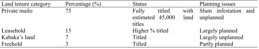
Table 1. The scope of land tenure and the occupancy question in Kampala
Land tenure category Percentage (%) Status Planning issues
Private mailo 75 Fully titled with
estimated 45,000 land titles
Slum infestation and unplanned
Leasehold 15 Higher % titled Largely planned
Kabaka’s land 7 Titled Largely unplanned
Freehold 3 Titled Partly planned
Source: Kampala City Council Development Plan, [2009 – 2011] Currently 75% of the land in Kampala is
categorized as mailo land, 15% as leasehold, 7% as Kabaka’s land and 3% as freehold. A large percentage of the mailo land is unplanned with several high density slum settlements (see Table 1).
Continued plot subdivision as well as piece meal releases of privately owned land in Kampala has contributed to disorderly urban development as well as the development of informal settlements
with no centrally provided services and infrastructure such as roads and piped water [Nawangwe et al. 2002; Kampala
City Council Development Plan, 2009].
By nature transportation planning is comprehensive and basic transport infrastructure such as roads cannot be planned on a single small plot of land of about eleven decimals (50feet x 100feet). The efficiency and accessibility of transport systems largely depend on the
LAND USE AND TRANSPORT Amin T.Kinggundu and Stephen Mukiibi utilization of urban land resources in part
because transport is a derived demand
derived from the man’s desire to travel and
participate in various human activities such as industrial work, settlement/housing and recreation [Van Acker and Witlox, 2010]
In large towns and cities such as Kampala travel patterns and commuting distances are mainly determined by the location of human activities such as recreation, housing/settlement and industrial production/work as well as the existing urban land use patterns [Van Acker and
Witlox, 2010; Litman, 2011].
Because of the over concentration of business activities in the city centre as well as the emergence of a mono-centric urban structure, many roads within the Greater Kampala continue to experience traffic jam especially during the morning and evening peak hour periods. Official figures show that the average traffic speeds in
Kampala are less than 15 kilometers per hour [Mukwaya, 2011].
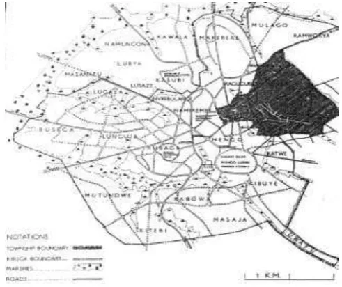
This paper examines the impact of land use on transport planning in the Greater Kampala. Greater Kampala extends to about 20kilometers from the city centre and to 40 kilometers along the rapidly developing peninsula up to Entebbe Airport. The total area is about 970 square kilometers. Greater Kampala also contains
8.5% of the country’s population, contains
up to half of the national vehicle population and accounts for perhaps 30 –
40% of Uganda’s gross domestic product
[image:3.595.187.408.443.607.2](GDP). In the next section, the methodology applied is explained. This is followed by a brief literature review on land use and transport planning. The planning experience from Kampala is discussed next. Also the paper identifies and presents key lessons drawn from the international experience. Following this section is the emerging policy issues and finally the conclusion.
Figure 1. Greater Kampala. Source: Ministry of Works and Transport, [2009]
THE METHODS
This paper is a result of the authors’ research work and investigative activities undertaken in the Greater Kampala on urbanization, transport and land use. Face to face interviews were also carried out with key informants such as the urbanization researchers, urban planners and transport experts at various locally
organized seminars and conferences. In addition, the study builds upon earlier studies conducted by researchers such as
Isolo [2011] and Nawangwe et al. [2002]
of Makerere University on sustainable transport and land utilization in Kampala.
Indonesian Journal of Geography, Vol 44, No. 1, June 2012 : 1 – 11 Current Land Use and Transport Policy
Debate
Two dominant camps according to
Bierman [2010] have emerged in the
current international urban land use policy debate. That is, the SmartGrowth (urban compaction/densification/new urbanism) camp and the urban sprawl (dispersed development/dynamic) city camp. The central ideology of SmartGrowth is that high urban densities and mixed use neighborhoods are critical in reducing travel distances, fostering public transit and non-motorized transport as well as reducing the use of private motor vehicles. SmartGrowth is also associated with low transportation costs and tends to improve the mobility options for the carless travelers and commuters [Van Acker and
Witlox, 2010]. More importantly, Smart
Growth promotes energy efficiency in large towns.
The urban sprawl/dispersed development or dynamic city camp however believes that low urban densities are not necessarily a bad urban development policy. The dynamic city camp (dispersed urban development) also questions the evidence which is presented by the Smart Growth lobby in support of compaction, centrality, public transit and higher densities and is opposed to the control-oriented solutions
[Litman, 2011; Bierman, 2010].
Proponents of Smart Growth however, cite Hong Kong, Singapore and Portland (Oregon) as role- model cities with high urban densities and high transit ridership. Current urban population densities in Hong Kong are 301 persons per hectare compared to 71 persons per hectare in Tokyo (Japan), 59 persons per hectare in Kuala Lumpur (Malaysia) and 46 persons per hectare in the Greater Kampala
[Kiggundu, 2009; Bierman, 2010; Barter,
1999].
In large towns and cities faced with obstinate transportation challenges such as
traffic jam and rapid motorization it is critical that an integrated approach towards land use and transport planning is adopted. This is so because transport is a derived
demand derived from the man’s desire and
wish to travel and participate in the various human activities such as housing/-settlement as well as industrial produ-ction/work [Van Acker and Witlox, 2010]. A change in the location of the human activities would also help in reducing travel distances and altering travel patterns
[Van Acker and Witlox, 2010; Barter,
1999].
Also worthy of mention is that in many large cities across the globe, rapid motorization has resulted in urban sprawl, high transportation costs, energy inefficiency as well as greenhouse emissions [Litman, 2011; Bierman, 2010].
Van Acker and Witlox [2010] aptly state
that cities with population densities of 100 persons per hectare are able to reduce the desire among the urban residents to own private cars by 4 –to- 6 percent.
Some research studies have however, questioned the effectiveness of land use-based strategies and policies in addressing transport challenges such as traffic jam and rapid motorization. Litman, [2011] for example argue that land use-based policies are often ineffective in part because a few cities have the institutional capacity and required financial resources to establish and enforce effective land use controls.
Critics also cite cities like Singapore and Tokyo where transport policy in form of congestion charges and other transport demand management (TDM) strategies has been effective in alleviating traffic jam and creating a conducive environment for the operation of public transport systems
[Barter, 1999; Kiggundu, 2009; Kiggundu
LAND USE AND TRANSPORT Amin T.Kinggundu and Stephen Mukiibi
Attribute Urban Sprawl SmartGrowth/New Urbanism
Density Lower urban density Higher urban density Location of human activities Commercial and institutional
activities are dispersed Commercial and institutional activities are concentrated into centers and downtowns Land use patterns Homogeneous land uses and
dispersed development Mixed land use and urban compaction Transportation patterns Automobile-oriented transportation,
poorly suited for walking and cycling Multi-modal transportation that support walking, cycling and public transit use
Street design Streets designed to maximize motor
vehicle traffic volume and speed Streets designed to accommodate a variety of activities and traffic calming programmers
implemented Planning process Unplanned, with little coordination
between jurisdictions and stakeholders
Planned and coordinated between jurisdictions and stakeholders
Source: Litman [2011] and Van Acker and Witlox [2010]
RESULTS AND DISCUSSION
Planning Experience from Kampala City
By 1906 on Figure 2, Kampala had been gazette as a township and became a city on 9th October 1962 [Nyakwebara, 2010; UN-Habitat, 2007]. However, the city got its first land use plan (planning scheme) in 1912. By then the entire township covered an area of 567 hectares and had a population of 2, 850 people [UN-Habitat, 2007].
[image:5.595.71.525.85.293.2]In 1930 see Figure 3 another planning scheme (land use plan) was introduced to regulate developments within the region. The 1930 land use plan for Kampala segregated residential, industrial and commercial areas as well as a well- planned civic centre [Nyakwebara, 2010]. Due to the rapid population growth, the first land use plans for Kampala became inadequate especially in terms of spatial coverage. In addition, urban development was taking place both inside and outside the official city boundary. (Figure 4)
Figure 2. Kampala Township 1910. Source: Kampala City Council
[image:5.595.174.420.508.714.2]5
Indonesian Journal of Geography, Vol 44, No. 1, June 2012 : 1 – 11
Figure 3. Kampala Land use plan 1930. Source: Kampala City Council
Figure 4. Development of Kampala City [Source: Kampala City Council]
Local pundits and urbanization researchers also argue that the continued presence of the two huge minibus terminals (old and new taxi terminals) in the city centre has negatively dented urban productivity as
well as the smooth flow of vehicular traffic. Besides, the location of the two terminals represents nothing but poor land use planning.
[image:6.595.125.474.397.655.2]LAND USE AND TRANSPORT Amin T.Kinggundu and Stephen Mukiibi
Figure 5. Low capacity minibuses in Kampala: A key source of traffic jam
Lessons from the International Experience
Across the globe there are a few cities that have managed to integrate land use and transport planning and to establish sustainable and efficient transport systems. In this paper two of these ‘role model’ cities (Hong Kong and Tokyo) have been selected and compared with Greater Kampala. In addition, in trying to compare the three cities, the authors are fully aware of the differences that exist in the urban environment such as level of development, size of urban population, institutional capacity and population densities. Kampala should however, aim to learn from developed and role model cities such
[image:7.595.67.531.553.775.2]as Tokyo and Hong Kong as a way of avoiding to repeat the past mistakes. Developing country cities such as Table 3 shows some of the strategies adopted by the two role model cities of Tokyo and Hong Kong to integrate land use and transportation planning. Among them is the creation of high density transit corridors. Under this strategy, high density commercial (shopping malls and office buildings) and residential (condominiums) buildings are constructed along the transit lines such as railway lines by the transit operators with the aim of benefiting from the increment in land and property value caused by the accessibility and expansion of public transport [Kiggundu, 2009], see Figure 5.
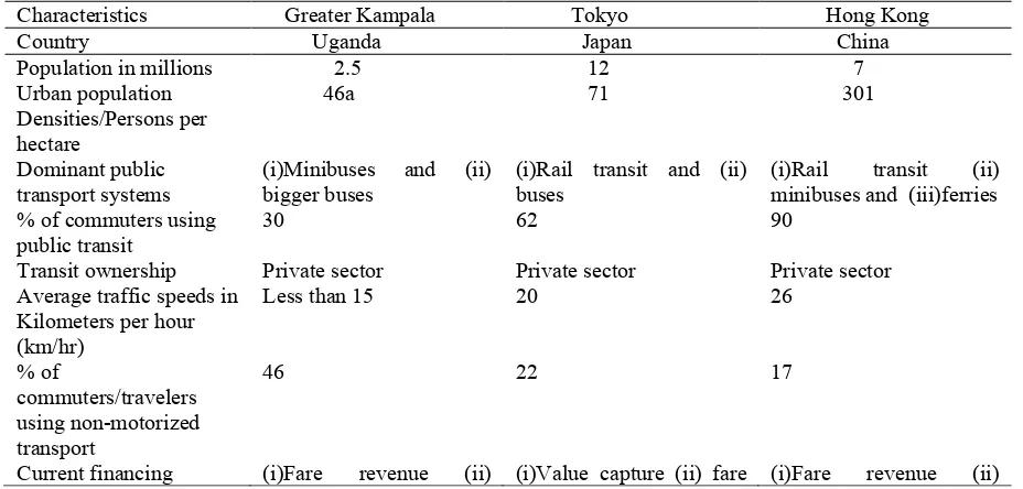
Table 3. Key urban features of Kampala, Hong Kong and Tokyo
Characteristics Greater Kampala Tokyo Hong Kong Country Uganda Japan China Population in millions 2.5 12 7 Urban population
Densities/Persons per hectare
46a 71 301
Dominant public
transport systems (i)Minibuses and (ii) bigger buses (i)Rail transit and (ii) buses (i)Rail minibuses and (iii)ferries transit (ii) % of commuters using
public transit 30 62 90
Transit ownership Private sector Private sector Private sector Average traffic speeds in
Kilometers per hour (km/hr)
Less than 15 20 26
% of
commuters/travelers using non-motorized transport
46 22 17
Current financing (i)Fare revenue (ii) (i)Value capture (ii) fare (i)Fare revenue (ii)
Indonesian Journal of Geography, Vol 44, No. 1, June 2012 : 1 – 11
systems for transit individual savings and
(iii) bank loans revenue, public-private partnerships (iii) tax exemptions (iv) Government rail development fund and (v) commercial loans
commercial loans and (iii) value capture
Land use policy (i)Not clear (ii) promotes urban sprawl (iii) lack of transit-oriented
development (iv) land use and transport planning not well integrated (v) promotes the use of private transport such as private cars and motorcycles
(i)High urban densities (ii) transit- oriented urban development (iii) integrated land use and transport planning and (iv) discourage the use of private transport and (v) park and ride facilities as well as (vi) transit malls
(i)High urban densities (ii) transit-oriented development (iii) integrated land use and transport planning (iv)discourage the use of private transport and (v) park and ride facilities as well as (vi) transit malls
Urban problems and
challenges faced (i)Urban sprawl (ii) mono-centric urban structure (iii) traffic jam (iv) rapid motorization (v) the surge in road accidents (vi) lack of transit –oriented development (vii) low urban densities,(viii) weak city institutions, (ix) informal settlements and (x) transit financing heavily depend on fare revenue, commercial loans and personal savings
(i)Congestion on trains, (ii)mono-centric urban structure and (iii) ageing population
(i)Traffic congestion (ii) poor air quality and (iii) lack of land
Source: Kiggundu [2009]; Ministry of Works and Transport [2009] and Rom Transportation
Engineering Ltd [2011]
NB: a = Estimates by the authors
Also under the high urban density strategy (also known as land value capture) adopted in both Tokyo and Hong Kong, high density developments attracted by the proximity to public transport helps to increase the catchment population as well as the demand for public transport services.
In Tokyo for example, the Tokyo Corporation bought low priced agricultural land in Tama new township west of Tokyo, built residential apartments and shopping malls which were either sold or rented to get the necessary capital to implement new rail projects [Kiggundu, 2009]. Tama new township was also built as a public transport-oriented urban centre
to reduce the financing risk associated with building the new rail infrastructure.
Besides in Tokyo private rail operators have been able to achieve success and to pay both capital and operating costs in part because the trains of different companies share the same rail-lines as a way of reducing costs [World Bank, 2000].
LAND USE AND TRANSPORT Amin T.Kinggundu and Stephen Mukiibi
Tokyo, 72 percent in Singapore, 31 percent in Kuala Lumpur and 30 percent in Kampala [Barter, 1999; Kiggundu, 2009]. Current land use policies in both Tokyo and Hong Kong have tended to discourage the use motorized transport and foster non-motorized transport such as walking and cycling. In Tokyo, 22 % of the commuters use non-motorized transport compared to 17% in Hong Kong, 22% in Singapore and 46% in Kampala [Barter, 1999]. A possible explanation for the high levels of use of non-motorized transport in Kampala could be the low income levels among the city residents as well as the low car- dependence levels (motorization) in the city.
It is also worth noting that in both Tokyo and Hong Kong land use policies in form of transit malls as well as park and ride facilities have been adopted to enhance the performance of public transport systems, discourage the use of private cars and reduce traffic jam. Normally, park and ride facilities are established near the transit stations away from the city centre to allow car users to park their cars and use transit to reach the city centre.
Available statistics show the current average traffic speeds in both Tokyo and Hong Kong are higher than those of Kampala. That is, in Hong Kong, average traffic speeds are 26 kilometers per hour (26km/hr), compared to 20km/hr in Tokyo and less 15km/hr in Kampala (see table 3).
Emerging Policy Issues and Future Prospects
Prospects for the future adoption of an integrated approach towards land use and transport planning in Kampala appears to be good but challenging at the same time. For instance, the recent introduction of the Kampala Capital City Act 2010 is a positive and clear sign that the central government has finally recognized the need to address the various challenges faced by Kampala, including land use planning (physical planning). Also under
the new Act new governance structures such as the Kampala Metropolitan Physical Planning Authority (KMPPA) have been established.
Among the key functions of the newly created Kampala Metropolitan Physical Planning Authority (KMPPA) are: (a) developing physical development plan for the capital city and the metropolitan area; (b) handling and addressing planning issues within the capital and the neighboring districts of Mukono, Mpigi and Wakiso; (c) planning major transportation, infrastructure and other utilities in conjunction with other relevant bodies; and (d) approving the capital city; municipal and town structure plans.
KMPPA is also mandated to ensure that
land use in the city and the metropolitan area follow designated plans, irrespective of the tenure of land.
By adopting a metropolitan planning approach, it is hoped and anticipated that the developments outside the official city boundaries will also be regulated. The problem with the new Act however, is that it over-centralized the planning functions. At the Division Urban Council level for example, there is no physical planning department provided for under the Act and yet much of the work carried out at the divisions is physical in nature.
Since the people (city residents) are in divisions and not at the centre, it would be prudent to establish fully-fledged physical planning departments/units at the divisions to regulate the various human activities including housing/settlement and transportation.
Without establishing fully fledged physical planning departments at the division urban councils in Kampala it is doubtful whether neighborhood structure plans will be developed by the divisions as stated by the Kampala Capital City Act 2010 (see page 67 of the Act).
Indonesian Journal of Geography, Vol 44, No. 1, June 2012 : 1 – 11
A further opportunity and innovative initiative is the introduction of the Greater Kampala Metropolitan Area Transport Master Plan [GKMATMP, 2009]. A key aim of this plan is to establish a transit-oriented city. GKMATMP also aims to curtail rapid motorization (increased use of private cars and motorcycles) in Kampala and promote Bus Rapid Transit (BRT).
Under the BRT project, four bus-ways are to be constructed over the period of 2012 – 23, with each bus-way taking three years to construct and operationalize at a cost of US$107 million per bus-way. The BRT
system is expected to be operating by 2014
[Greater Kampala Metropolitan Area
Transport Master Plan, 2009].
The BRT project however is faced with an obstinate challenge of low urban densities. The current urban densities of about 46 persons per hectare in Kampala are too low to generate enough demand and to ensure that a self-financing transit system is established. Without a clear strategy to restrain the use of private vehicles especially private cars and motorcycles (also locally called Boda Bodas) it is virtually impossible to establish an efficient transit system in Kampala.
CONCLUSION
Urban land use (urban form) has a big impact and influence on the planning and management of transport systems. Land use also determines the quality and quantity of the transport services provided in large towns and cities. In Kampala however previous land use plans (planning schemes) have made very little impact especially in promoting orderly urban development and enhancing the per-formance of the transport systems. Besides the city authorities have failed to integrate land use and transport planning and each of the two activities is still undertaken separately and without coordination.
Land use planning in Kampala has also been affected by the existence of a complex land tenure system that is dominated by the private land owners who prefers releasing their land in piece meal and in small plots. Above all, urban densities in Kampala are too low in part because of urban sprawl. However the adoption of several new strategies such as the establishment of the Kampala Metro-politan Physical Planning Authority as well as the introduction of the Greater Kampala Metropolitan Area Transport Master Plan to promote orderly urban development and improve land use planning in Kampala appears to have improved the prospects for achieving orderly urban development and adopting a coordinated approach towards land use and transport planning in the region.
Experience from the role model cities such as Tokyo and Hong Kong also shows that high urban densities are critical in creating the necessary demand for public transport as well as in reducing commuting distances and transportation costs. Besides in both Tokyo and Hong Kong land use-based policies such as land value capture as well as the construction of high density buildings (both commercial and residential buildings) along the transit lines have been adopted in enhancing the performance of public transport systems and integrating land use and transport planning.
It is also clear from preceding parts of this paper that land use is a critical factor influencing transport planning and that the failure to integrate land use and transport planning is the main source and cause of the poor transport services in many parts of Kampala. However, land use based policies such as constructing high density residential buildings along the transit lines tend to be long term in nature and requires a lot of financial resources to be imple-mented, which many developing country cities like Kampala may not be able to mobilize.
LAND USE AND TRANSPORT Amin T.Kinggundu and Stephen Mukiibi
Besides, in some foreign model cities such as Singapore, transport policy in form of congestion charges (road pricing) and other transport demand management mea-sures has been effective in curbing rapid motorization, alleviating traffic jam and fostering public transit.
REFERENCES
Barter, P.A. (1999), an International Comparative Perspective on Urban Transport and Urban Form in Pacific Asia: Responses to the Challenge of Motorization in Dense Cities, PhD Dissertation, Murdoch University.
Bierman, S. (2010), The Role of Urban Form in Achieving Sustainable Transport and Mobility, In The Sustainable Transport & Mobility
Handbook, South Africa, (1) 95-99.
Kampala City Council (2009), Kampala City Council Development Plan
(2009-2011), Kampala: KCC.
Kiggundu, A.T. (2009), Financing Public Transport in Kuala Lumpur, Malaysia: Challenges and Pros-pects, Transportation (36) 275-294.
Kiggundu, A.T. and Jamilah, M. (2007), the Rise of the Private Car in Kuala Lumpur, Malaysia: Assessing the Policy Options, IATSS Research Journal, (31) 1-9.
Litman, T. (2011), Evaluating Transpor-tation Land use Impacts..Consi-dering the Impacts, Benefits and Costs of Different Land use Development Patterns, 15th April
2011, Victoria Transport Policy Institute, (Online) Available from: www.vtpi.org
Ministry of Works and Transport (2009),
National Transport Master Plan Including A Transport Master Plan for the Greater Kampala
Metro-politan Area, Kampala: Ministry of
Works and Transport.
Mukwaya, I.P. (2011), Sustainable Urban Transport---Kampala’s State &
Future, Paper presented at a
workshop organized by Kampala City Council, 13th April 2011 at
Imperial Royale Hotel, Kampala.
Nawangwe, B. et al. (2002), Land Tenure and Administrative Issues in Kampala City and Their Effects on
Urban Development, Research
Report Submitted to Makerere University, August 2002. Kampala.
Nyakwebara, C. (2010), Chronology of Planning in Kampala: Implications for Future Structure Planning, the
Urban Planning Magazine, (1),3-6.
UN-Habitat (2007), Situation Analysis of Informal Settlements in Kampala,
Nairobi: UN-Habitat.
Van Acker, V. and Wiltox, F. (2010),
Commuting Trips Within Tours: How is Commuting Related to Land Use, Transportation, (38)
465-486.
World Bank (2000), Study on urban transport development, Final
Report, Prepared by Padeco Ltd.
![Figure 1. Greater Kampala. Source: Ministry of Works and Transport, [2009]](https://thumb-ap.123doks.com/thumbv2/123dok/854001.815509/3.595.187.408.443.607/figure-greater-kampala-source-ministry-works-transport.webp)