INFORMATICS INTERPRETATION OF THE VISIBILITY BETWEEN TWO GEODESIC POINTS
Ioan Ienciu
Abstract.When solving geodesic problems, informatics is the support for a fast and precise determination of geodesic networks, namely of the visibility between points, for the optimal form of geodesic networks triangles as well as for a substantial economy of time and money.
The informatics solution of the visibility between two points uses the concept of ”visibility rectangle”, meaning a mathematical solution put into an informatics support of the problem ”when does a point belong to the visibility rectangle?”. This problem will be solved by comparing the surfaces of the visibility rectangle to the sum of surfaces formed by a point with the sides of this rectangle.
1.Introduction
In sight of drawing up a topographic plan it needs the determination of a sufficient number of points which, through their pozition on the plan against a certain reference system, rendering the plane image of the ground. The inspection points of the reference system can be situate at excess length against the land who size, form and surface we want to determinate and for this reason we must to position new points for the geodetic support network.
2. Tehnical Conditions
The projection of new points of the geodetic network is directed to: • the points need to cover entire zone when it follows to achieve the
• achieving geometric simple forms where the triangles don’t have angles with small size then 30g;
• the points can be plant easy in grounds; • the possibility of quick access to points;
• existing the visibility between points in both directions.
Last condition assumes another travelling on ground to can determinate the visibility between two geodetic points, determination who requires a big consumption of material funds and human.
This travelling may be remove using a macrolanguage to define a function of a visibility between two geodetic points who can achieve easily using as a source datas the graphics coordinates. Like a programming language it was chosing the Visual Basic which puts at command designer of applications a concourse a visual elements which standards define a graphic interface.
3. Informatics Interpretation of the Problem
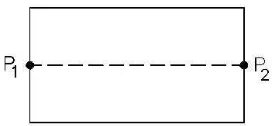
At the beginning I shall define a concept concerning the rectangle of visibility. Through rectangle of visibility format of the points p1 and p2 we understand the rectangle who contains between his small sides, with length until 10m, these two points, and the big sides are taking by the average of superior and inferior limit for each order of triangulation network, average called diameter. This is calculating with the follow relationship:
[image:2.612.204.343.524.587.2]Diameter=(limsup+liminf)/2.
Using these conditions, the define function returns True if the two points p1 and p2 using as parameters ”are seeing” (there isn’t another points from grid which obturate them) and he returns False, otherwise. The algorithm in abstract code, on the strength of whom it implemented this function is next:
Algorithm visibility ( p1, p2: Point) is:
Source datas: p1,p2: Point;
Visibility: = True; * is presupposed that these two points are seeing*/. For i: = 1 to ngrid executes /* ngrid represents the number of points from initially grid and it is global variable*
* if the current point from grid i is found out in the rectangle of visibility then
visibility: = True.
* if the current point is obtureating the visibility then
visibility: = False;
4.Solving the Problem
To resolve these two logical functions:
* if the current point from grid i is found out in the ”visibility rectangle” and
* if the current point is obturating the visibility it established next:
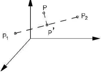
At the beginning is establishing if a certain point from initially grid, where the point ”i” is found out in this established rectangle, and he can obturate the visibility among the points p1 and p2.
A certain point ”i” of initially grid is placed inside the rectangle of visibil-ity if it carries out the condition as the the sum of the areas of the resulting triangles between this point and each side of the rectangle must be less or coequal with the area of the rectangle. In this case which points that verifies this condition shall be past in a new grid which we will work in the next phase.
At the second phase, all the points ”i” which verifies the condition of placed inside the ”visibility rectangle” will be submissive the next test, re-spectively it will check up if it obturates or not the visibility betweenp1 and
The point ”i” obturates the visibility among p1 and p2 if the height of the point (Zi) is elder than the height of the point resulting at the intersection between the perpendicular from the point ”i” and the line generated from the points p1 and p2.
Figure 2: Visibility between two geodetic points
The calculus of surfaces was making using the Heron formula for which the lengths of sides were calculating initial from the planes coordinates of these points and which were comparing with the calculating surface for rectangle.
5. Conclusions
Considering that the apparatus using to crunch the geodetic network, indifferent from them type (GPS, total stations with angular precision or theodolites with high precisions), are using, like a principle from determinate the points, the triangle relationships concerning at angles, sides or both of them, it’s strongly recommended to respect the tehnical conditions to realise the geodesic network.
cost of the land operations and the allocated time of a work from new points geodesic determination.
References
[1] Craig, C.J.; Webb, T. - Visual Basic 5.0.- manualul programatorului, Teora Publishing House, 1998.
[2] Dima, N. -Teoria erorilor si metoda celor mai mici patrate, University of Petrosani, 1992.
[3] Dima, N. - Geodezie, University of Petrosani, 1982.
[4] Ienciu, I. - Exploatarea programelor topo cadastrale, Suport de curs -postuniversitar, University ”1 Decembrie 1918”, Alba Iulia, 2003.
[5] Ienciu, I. -Analiza tehnologiilor de realizare a retelelor geodezice locale, Paper in training of examination for a doctor’s degree, Petrosani.
[6] Ienciu, I. -Corelarea lucrarilor geodezice cu lucrarile cadastrale, Paper in training of examination for a doctor’s degree, Petrosani.
[7] Ienciu, I.; Dimen, L. - Optimisation Possibilities of the Geodetically Network, Proceedings of 3rd International Conference of Phd Students, Miskolc, Hungary, 2001.
[8] Ienciu, I.; Rsteiu, M. - Baze de date n topografie si cadastru, Suport de curs, University ”1 Decembrie 1918”, Alba Iulia, 2002.
[9] Neuner, J.-Sistemul de Pozitionare Globala, Matrix Publishing House, Bucuresti, 2000.
[10] Rsteiu, M.; Ienciu, I.; Wainberg, D. - Suport informatic de digitizare a datelor din topografie si cadastru, Aeternitas Matrix Publishing, Alba Iulia, 2003.
Author:
Ioan Ienciu
”1 Decembrie 1918” University of Alba Iulia, str. N. Iorga, No. 11-13, 510009, Alba, Romania,