Ahanta
West
Tamale
Burkina FAso
T
ogo
Iv
o
r
y C
o
a
st
Accra
Takoradi
Kumasi
Integrated Coastal and Fisheries Governance Initiative
Integrated Coastal
Management Toolkit
This publication is available electronically on the Coastal Resources Center’s website at http://www.crc.uri.edu.
For more information contact:
Coastal Resources Center
Friends of the Nation
Hen Mpoano
University of Rhode Island, http://www.fonghana.org http://www.henmpoano.org
Narragansett Bay Campus [email protected] P.O. Box AX 296
220 South Ferry Road P.O Box MC 11 Takoradi
Narragansett, Rhode Island 02882 Takoradi, Western Region, Western Region
USA Ghana Ghana
Brian Crawford, Director of International Programs Email: [email protected] Tel: 401-874-6224 Fax: 401-874-6920
Please cite this report as:
Coastal Resources Center (2013). Ahanta West District Integrated Coastal Management Toolkit. Integrated Coastal and Fisheries Governance Initiative (Hen Mpoano) Narragansett, RI: Coastal Resources Center at the Graduate School of Oceanography, University of Rhode Island 54 pp
Disclaimer:
This publication is made possible by the generous support of the American people through the United States Agency for International Development (USAID)/Ghana. The contents are the responsibility of the authors as part of the Integrated Coastal and Fisheries Governance (ICFG) Initiative and do not
necessarily relect the views of the United States Government. Associate Cooperative Agreement No.
641-A-00-09-00036-00 for “Integrated Coastal and Fisheries Governance (ICFG) Program for the Western Region of Ghana,” Under the Leader with Associates Award No. EPP-A-00-04-00014-00.
Acknowledgements
With funding from the United States Agency for International Development (USAID), the Coastal Resources Center of the Graduate School of Oceanography at the University of Rhode Island have worked together with core partners
including Friends of the Nation, Worldish and Sustainametrix to implement the
Integrated Coastal and Fisheries Governance (ICFG) Initiative, locally known as Hen Mpoano. We are pleased to compile a compendium of Integrated Coastal Management (ICM) information and knowledge generated through this 4-year Initiative into a toolkit to inform district level planning and management of
coastal and marine resources. Compilation of this material beneited from the
contributions of a large number of colleagues and practitioners, including many members of the coastal communities of the Western Region of Ghana and beyond, who have assisted in information gathering, research and analysis. We sincerely acknowledge the contribution of the planning departments of the six coastal districts of the Western region in supporting the development of innovative processes that builds ICM into district planning processes and decision making procedures. We are also grateful to the following individuals for providing technical insights and guidance during the production of this material: Dr. Christopher Cripps (Spatial Solutions), Dr. Donald Robadue (Coastal Resources Center, University of Rhode Island, USA), Stephen Kankam (Hen Mpoano), Pamela Rubinoff (Coastal Resources Center, University of Rhode Island, USA), Hillary Stevens (Coastal Resources Center, University of Rhode
Island, USA) and Koi Agbogah (Hen Mpoano). The graphic designs and layouts
as well as GIS mapping have been done through the hard work of Justice Camilus Mensah (Hen Mpoano) and Lucia Rybarova (Oil City Magazine).
Finally, we would like to acknowledge the fruitful collaboration developed with
key oficials and institutions, without which this toolkit will not have been
possible. At the regional level the partnership developed with the Members,
Chief Executives, Directors and Oficers of the District Assemblies, Regional
Statement from Honourable
Joseph Dofoyenah, District
Chief Executive of the Ahanta
West District Assembly
I have to give the sincerest thanks to the Coastal Resources Centre for the huge amount of effort that has gone into the making of this toolkit for our District.
Since their beginning in 2009, CRC Ghana and their partners, whose initiative has become known as “Hen Mpoano”, have transformed the way in which we, and others, have come to regard our coast and our coastal communities. Now, apart from changing views of what the coast is all about, and giving voice to those living and working there, CRC has helped us to make some serious inroads into the policies and structures of government regarding the coast.
This Toolkit has put together their indings and
evidence gathered from 2009-2013, summarises the tools that have been developed during that time for all of us to tackle the problems and grasp the opportunities that exist. It tells us how to counter and avoid all the potentially destructive and harmful challenges which are being faced, and shows how the coast may become a place of pride, or harmony, of abundance based on the rich resources that have been enjoyed by its peoples for centuries past, while welcoming the incredible technologies of the 21st century which are now well among us.
I strongly recommend this toolkit to all who are living, working and those who are investing in our coast.
lood and drought), causing
sea levels also to rise.
Community Resourced Management Areas (CREMA): creates a win-win situation by creating a
inancial incentive for farmers
to use and manage natural resources on sustainable basis by devolving management rights and responsibilities to them.
Development: is any man-made alteration to the landscape including grading,
illing, dredging, extraction,
storage, subdivision of land, or construction of structures, stormwater collection, drainage and discharge
works, lood protection
works.
Ecosystem: a complex set of relationships among the living resources, habitats and residents of an area. It includes plants, trees,
animals, birds, ish,
micro-organisms, water, soil and people. Everything that lives in an ecosystem is dependent on the other species and elements that are part of that ecological community.
Eco Tourism: is a a form of tourism involving visiting fragile, pristine, and relatively undisturbed natural areas, intended as a low-impact and often small scale alternative to standard commercial (mass)
Adaptive Capacity: capacity of a community to adapt itself to the threats and hazards such as climate change, coastal erosion, loss of livelihoods and inappropriate development.
Artisanal Fishing leet:
traditional canoe-based
ishing vessels.
Barrier spit or beach:
sandy beaches built up by ocean wave energy and backed by wetlands or river
outlows. These systems are
in constant movement in response to the energy of the surrounding system.
Built Areas Highly
Exposed to Flood Damage:
are settlements, businesses, residences and public
buildings which are routinely
submerged by lood waters,
erosion or damage from high velocity stream and drainage
low.
Carbon Sequestration: the absorption of carbon dioxide (a “greenhouse gas” which is responsible for global warming) by vegetation.
Catchment Area The area receiving the waters feeding a part or the totality of a watercourse or watershed.
Climate Change: the changes in climate which are being experienced, including extremes of weather (storms,
Definitions
tourism. Its purpose may be to educate the traveler, to provide funds for ecological conservation, to directly
beneit the economic
development and political empowerment of local communities, or to foster respect for different cultures and for human rights.
Ecological goods and services: are the beneits
provided by wetlands e.g.,
water puriication, supplies of portable water, ishes,
plants, building materials and water for livestock, outdoor recreation and education.
Environmental
Assessment: is the process of identifying, predicting, evaluating and mitigating the biophysical, social, and other relevant effects of development proposals prior to major decisions being taken and commitments made.
Erosion: is the removal and transportation of soil particles by the action of water, wind, gravity or other geographical agents, whether naturally occurring or acting in conjunction with or promoted by man - made activities or effects.
higher as a result of the
inluence of the sea.
Flood: an overlow of rain
water or other sources along
the normal conines of a
river, stream, drainage way or other water body that causes or threatens damage to property, infrastructure, people, or natural resources
Flood prooing or protection: means any combination of structural and non-structural additions, changes, or adjustments to existing or new structures which reduce or eliminate
lood damage to residential
and non-residential buildings and their contents. These can include protective walls and drainage systems to redirect water away from existing buildings, rebuilding structures to make them more resistant to the
intrusion of lood waters
or the physical force of high velocity water. It also includes special design and construction techniques including piers and elevating
the lowest usable loor of a
building above the level of water experienced in events.
Floodplain: a level or nearly level land along a
stream or river looded only when the stream low
exceeds the water carrying
capacity of the channel. lat or nearly lat land adjacent
to a stream or river that
experiences occasional or
periodic looding.
Green Belt: an area which has been designated around a settlement for no development in order to provide access to green and open spaces and to encourage more dense urbanization.
High tide line: is the highest point on the shore that is covered by water at high tide. Ghana has two high tides and two low tides each day. The mean tidal range (distance between high and low tides) is 1 meter, and the spring tidal range (time of new or full moon) is 1.3m. For purposes of coastal development, this is the line which development is set back from.
Lagoon: closed or open, a shallow body of water separated from the ocean by a barrier island or spit. It may be open to the ocean occasionally during seasonal
looding or high seas.
Pair Trawling: the joining of nets to two boats in order to increase catches.
Pocket beach: a short sandy shoreline between rocky headlands that prevent long shore transport of sediment.
Restoration: is a broad process of reversing physical, economic and social decline in a coastal area.
Set back: is an area left free of any physical development
or modiication, commonly
used to setback structures from a coastal feature, or from a road in an urban area.
Shoreline protection
structures, or sea defense structures:
include breakwaters, groins, bulkheads, jetties, and other structures, the purpose or effect of which is to control or prevent the erosion of coastal features.
Traditional Authorities:
the traditional governance system of chieftaincy in Ghana.
Watershed: area of land where all of the water that is under it or drains off of it goes into the same place, such as a river or a wetland.
Water dependent uses:
are uses that can only be conducted on, in, over, or adjacent to the water; each involves, as an integral part of the use, direct access to and use of the water. These uses cannot physically function without direct access to the body of water along which it is proposed.
Examples of water dependent
uses include: docks, piers, ish
processing facilities, canoe/ boat repairs, port activities requiring the loading and unloading of vessels. Water dependent uses exclude housing, hotels, motels, restaurants, warehouses, manufacturing facilities (except for those which receive and quickly process raw materials by ship) etc.
Wetland: means land which is transitional between terrestrial and aquatic systems where the water table is usually at or near the surface, or the land is periodically covered with shallow water and which land in normal circumstances supports or would support vegetation typically adapted to life in saturated soil. Functions within the natural ecosystem
include lood attenuation
and control, maintenance of underground and surface water supplies, sediment trapping, erosion control, pollution abatement and
provision of habitats for lora
INTRODUCTION
Hen Mpoano and Ahanta West District Collaboration
This Toolkit is the inal output, for Ahanta West District, of the Integrated Coastal and Fisheries
Governance (ICFG) initiative, which has become locally referred to as HεN MPOANO (Our Coast). It is a
four-year project carried out by the University of Rhode Island Coastal Resources Centre and partners (see acknowledgments),and funded by the United States Agency for International Development (USAID).
The Overall Goal of the Hen Mpoano Initiative
Overall Goal: to support the Government of Ghana in achieving its development objectives of poverty
reduction, food security, sustainable isheries management and biodiversity conservation.
The initiative’s vision is that:
Ghana’s coastal and marine ecosystems are sustainably managed to provide
goods and services that generate long term socio-economic beneits to
communities while sustaining biodiversity.
The purpose of the Integrated Coastal Management Toolkit for Ahanta
West District and how to use it
• It is a catalogue which summarizes the marine and coastal information which has been gathered by Hen Mpoano. It is for use by all of those who are actively involved in carrying out Integrated Coastal Management in Ahanta West District including the Coastal and Marine Management Committee.
• It provides easy-to-follow links to the source material, more detailed technical information.
• To suggest “Projects” for incorporating Integrated Coastal Management in the planning processes and practices of the District Assembly.
Contents of the Toolkit
Section
ONE:
The Coastal Zone and Development Context
TWO:
Integrated Coastal Management
THREE:
Ahanta West District Coastal Profile and Development Issues
FOUR:
Integrated Coastal Management Institutions and Processes
FIVE:
Bibliography of Documents and Maps produced by the
Integrated Coastal and Fisheries Governance Programme
SIX:
Best Management Practices
I
ntr
o
duc
ti
o
Legend
Ecotourism
Fish landing site
Fort/castle
Lighthouse at Cape Three Points
Accomodation facility
Sandy beaches Coastal lagoon inlet
Rocky shores N1/Highway Major road Proposed roads Buffer
Perception of shoreline 30 years ago Perception of shoreline 60 years ago Shoreline extend within community Drains
100 year shoreline Green belt
Gas pipeline
District boundary
Water body
River
Mangroves / Wetland
1974 shoreline
Natural vegetation
Tidal inluence (yet to be determined)
Coastal Zone
Town
Community Resources Management Areas (CREMAs)
Coastal zone (1000 m buffer)
Birds
Crocodiles
Turtles / nursery
Project proposed to be
implemented. Refer to
pages 42-44 for more
information.
Bibliography listed in
section ive.
Examples of Best
Management Practices
in coastal communities
Project
Reference
The Coastal Zone
and Development
Context
Section
one:
1
s
ec
ti
o
n The Coa
st
al Zo
ne and D
e
ve
l
o
pme
nt Co
nte
x
Pocket beach
Watershed draining into
river Upland Forest
River Delta Rocky
Shore Rocky Headland
Rocky Shore
Barrier beac h/
spit (backed by lagoon)
Estuary Lagoon (tidal)
Akwidaa New Town
Akwidaa Old Town
FLOOD ING
FLO O D IN G FLO
O
D
IN
G
Waves that can cause erosion
Net Long s hore current an
d sand movement
Beach, berm, dunes
River – fresh/salt boundary site
speciic
Wetlands & mangroves SALT BRACKISH
FRESH
Turtle nesting beach Road to D
ixcove River rises with heavy
rain
Coastal features:
• Beaches, Dunes and Barrier Spits, Rocky Bluffs, Rock Outcrops and some Steep Slopes
• River Estuaries, Drainage Outlows, Mangroves,
Wetlands Marshlands and Coastal Lagoons
• Flora, tropical foliage forests, fauna, birds, small invertebrates, sea turtles
Dynamics:
Sandy shorelines are highly dynamic features that evolve in response to waves, currents, tides and wind. In many cases sandy beaches are built up by ocean wave energy and backed by wetlands
or river outlows, and are referred to as barrier
beaches. These systems are in constant movement in response to the energy of the surrounding system, and as a result are not advisable building sites.
Figure 3: Detail of coastal zone showing typical features Source: CRC Ghana
1
s
ec
ti
o
n The Coa
st
al Zo
ne and D
e
ve
l
o
pme
nt Co
nte
x
Integrated Coastal
Management -
why, what and how?
Section
two:
2
s
ec
ti
o
n I
ntegra
te
d coa
st
al m
anageme
2.1 Why?
The coast of Ahanta West District surely represents its most distinctive feature, and the one which gives its greatest competitive advantage. But the development opportunities need to respect the right of communities, which have lived here for centuries past, to also continue to enjoy a prosperous and harmonious life. All will have to meet the ongoing socio-economic challenges exacerbated by climate change and coastal erosion. Those inland, within the District, are also highly dependent on the health and well-being of the coast.
industrial and other related development as well as pressure on the coastline for development of residential, leisure and hospitality. This is coupled with the long established use of large tracts of land for plantation agriculture, notably oil palm and rubber. These factors have impacted
adversely on the space available for ishing
and for subsistence agriculture.
• Fisheries decline: declining ish catches,
(mostly attributed to increased canoe numbers due to increasing population) and
unsustainable ishing methods has led to poor ish quality and consequently poor life span of processed ish. Other factors are conlicts between artisanal and semi-industrial ishers/boats and non-existent/
weak local institutions for managing the
ishery.
• Coastal Eco-Systems threatened:
Incidence of sand winning and sea erosion, destruction of mangroves, wetlands and drainage systems
• Other concerns: community perception of inadequate government representation and attention; chieftaincy disputes; poor road access/infrastructure; inadequate Primary and Junior High school educational infrastructure, electricity, pipe-borne water, toilets, health posts and refuse containers.
2.3 What? The Core
Elements of Integrated
Coastal Management
The response to pressures of development
could in fact generate long term beneits
for coastal ecosystems and their dependent communities. With this in mind, the District Assembly has inaugurated a Coastal and Marine Management Committee to drive Management Strategy, of which the core elements are:
• Preservation and restoration of important coastal habitat and features that are
critical to sustaining the ishing industry
R1: Our Coast, Our Future: Western Region of Ghana
This is a major product of the Hen Mpoano initiative. It makes the case that a fresh approach to the governance of the coast and isheries will take root only when it addresses issues that are perceived by the people of the place as important. It covers the major coastal and isheries issues and concludes with a discussion of the actions that Hεn Mpoano proposed to take over a three year period to establish and formalize a governance program for the Western Region that can serve as a model for the nation.
Reference
2.2 The Most Urgent Issues
The coastal zone of Ahanta West District is undergoing rapid transformation due to activities of a fast growing oil and gas industry. A balance must be found between
development and the low of coastal ecological goods and services. There is a need to conine
oil and gas-related development to certain
“hot spots” (as identiied, for example by
the Western Regional Spatial Development Framework), to maintain sustainable
livelihoods, protect the environment and the areas of high landscape value (“green belt
areas”) which have been identiied, while
encouraging economic development.
The Rapid Assessment of Communities in Ahanta West showed the following key points:
• Expanding Community Resource
Management Areas (CREMAs) in existing conservation management clusters to cover other important coastal wetland areas including improving conservation and management systems for the Cape Three Points Forest.
• Creating Land Use and Environmental Policies that balance competing interests of industrial, tourism, food and livelihood security, leisure, commercial and
residential activities while protecting the vital ecological functioning of the land and seascape.
• Supporting traditional and inding new
livelihoods for coastal communities
through agriculture, isheries and
aquaculture, as well as providing the access to fully partake in the new forms of development.
• Reducing vulnerability and building adaptive capacity of coastal communities to threats from hazards and climate change including extreme weather, rising sea levels and coastal erosion.
• Sustained stakeholder enagement and moves to build co-operation with neighboring districts through a Joint Coastal Development Planning Area; and creating effective links to the regional and national levels of government.
2.4 How? Systems for
implementing Integrated
Coastal Management
Integrated Coastal Management is a participatory process that engages communities, private sector, traditional authorities and civil society. The mechanisms for implementing at the district level are:
1. The District’s Medium Term Development Plan (MTDP), and Community Action Plans which address settlement growth, economic development and the provision of schools, clinics, other services, roads and infrastructure.
2. The District’s Spatial Development Framework (SDF), Structure Plans (SPs and Local Plans (LPs), which show what can go where, and resolve potentially
conlicting demands on land use in the
coastal zone.
3. Strategic Environmental Assessment which ensures that the necessary environmental protection measures are taken.
The establishment of a District Coastal and Marine Committee is a great step forward for implementing Integrated Coastal Management. It provides a necessary forum for stakeholders
involved in such sectors as isheries, oil and
gas, land use planning and fresh water supply. It brings the concerns of coastal communities to the attention of the assembly for translation into plans and procedures. The Committee can identify and assess issues, suggest and shape policies, prioritize actions and evaluate outcomes as the Coastal Zone is developed.
At the regional and national scales, many of the objectives of coastal management may only be achieved through joint planning and implementation, involving adjoining coastal districts. For this reason, initiatives such as the Data Hub which has been established at the Western Regional Coordinating Council by Hen Mpoano for technical support, the
ledgling Joint Development Planning Area for
the Coastal Districts of the Western Region, and Western Corridor Development Authority must be supported by all.
This joint approach to planning and decision-making can involve:
• Adoption of region-wide policies for
preventing and mitigating lood hazards;. • Information sharing on techniques for
assessing hazards and adaptive capacity of coastal places (eg those used in vulnerability assessment and adaptive planning exercises at Dixcove and Akwidaa).
• Collaboration between agencies at regional and national levels on coastal issues.
• Effective mechanisms for conlict resolution
• Joint initiatives on protection/restoration of critical habitats, forests and wetlands of
regional signiicance by programs such as
Community Resourced Management Areas (CREMAs).
• Decision making on large facility siting and management of alterations of the coastal zone.
All of these will become more evident in the coming years if detailed planning and decision-making can be done at community level and linked to regional and sub-regional co-ordination of national and international investments.
P1: Form Working Groups to deal with speciic
coastal issues, for example the Cape Three
Points Working Group
Project
2.5 Opportunities to
Implement Integrated
Coastal Management
Section
three:
AHANTA WEST DISTRICT
COASTAL PROFILE AND
DEVELOPMENT ISSUES
3
s
ec
ti
o
n AHANT
A WEST D
ISTRI
C
T COA
ST
AL PR
O
FILE AND D
E
VEL
O
Reference
Cape Three Points forest reserve
Mangroves
Esilo
Be
estuaries, ishing villages, and historic
forts combine to give this section
of coast its unique qualities.
locally breeding ish, those inhabiting the Guinean
current across West Africa and those that migrate across larger distances. Surveys have been carried out to determine the location and type of marine
life including juvenile ish and their breeding, and
Marine Protected Areas are being proposed to
protect isheries and improve food security.
Marine areas experience many other uses such as for a local, national and international highway, for
Figure 4: Ahanta West District shoreline.
Source: CRC Ghana
Princes Tow
n
Aket akyi Egyambr
a
3.1 Characteristics of the
Coastal Zone: overview
The Ahanta West District shoreline is relatively rural with a mix of land and water uses which underpin local cultures and livelihoods. It includes rocky outcrops of hills that protrude between sandy beaches, or sometimes extending into the sea forming rocky sea bed. There are capes and bays, most notably “Cape Three Points”.
The beaches are gently sloped to generally lat
and patched with sandy mounds and boulders. The coast line is dotted with hospitality facilities,
dense human (ishing) settlements with ish
landing and processing areas, river estuaries and
ecologically signiicant wetlands that are habitats for diverse lora and fauna. In the uplands there
are patches of forest and rich agricultural lands.
The shoreline from the western district boundary not far from Axim, to the Butre estuary, which includes the famous Cape Three Points, the
southernmost tip of Ghana, is arguably the section of the Ghana coastline with the highest landscape value and natural beauty. Spectacular barrier beaches and sand spits have formed at its major river estuaries (Nyan and Ezile) creating natural
harbours for the ishing communities along the
coast at Princes Town, Akwidaa, Dixcove, Busua and Butre. European traders also built their now historic forts close to these natural harbours on rocky islands and outcrops.
The extraordinary
combination of beaches and rocky outcrops,
The coast between the Butre and Hwin Estuaries (forming the eastern boundary with Sekondi Takoradi Metropolitan Assembly) houses several
highly impoverished ishing communities but has
less landscape value. It is becoming subjected to intense pressures from industrial development as Sekondi Takoradi expands westwards towards the oil and gas and mining areas.
R2: Adaptive Capacity for Resilient Coastal Communities:
Climate Change and Natural Hazards Issues in Coastal
Districts of Ghana’s Western Region
In 2011 and 2012, Hen Mpoano assessed 77 Western Region coastal communities in the Districts of Jomoro, Ellembelle, Nzema East and Ahanta West to gain an understanding of their concerns
and capacity. The indings indicated that adaptive
capacity is limited in coastal communities. Some locations are faring better than others, but overall, coastal communities have weak ability to respond to emergencies generated by natural hazards, they suffer social and economic development challenges that are worsening, and they have a relatively low ability to manage coastal resources in a way that will ensure sustained productivity and environmental quality.
3.2 Characteristics of Coastal
Zone: off-shore marine areas
and isheries:
The off-shore areas of the coastal zone are
actively used by the artisanal (traditional) ishing leets. Fishing is also the province of larger, Ghana-based semi-industrial ishing vessels and
Achonw staff of the Western Regional branch of the Ghana
Canoe Fishermen Association and a staff of the Friends of the Nation. Data was collected through focus group discussions, participatory mapping, direct observations and key informants interviews.
R5: Determining The Origin And Ecology Of A Macroalgae
(Ulva clathrata) Bloom Along The Coast Of Western Ghana
And Cote d’Ivoire.
The Ghanaian Ministry of the Environment worked with The Integrated Coastal and Fisheries Governance (ICFG) and CRC-Ghana to form a Task Force of collaborating institutions to extend a survey into Cote D’Ivoire in order t more fully describ the ecology of the
o
leisure, cables, pipelines, oil and gas exploitation. The Marine areas are subject to increasing kinds of pollution from the wastes of marine and non-marine activities (dumping of waste). As capacity for coastal management increases, spatial planning for the seascape will be necessary to ensure harmony between traditional uses of
the sea for ishing and oil and gas production
activities. Marine Spatial Plans are now being used throughout the world to cope with the increasing pressures.
P2: Prepare Marine Spatial Plan
P3: Continue with research on Algae
Project
Bloom leading to proposals for its
management.
R3: Nearshore Rocky Reefs of
Western Ghana, West Africa:
Reference
Baseline ecological research surveys.
Ateweberhan,M.,Gough,C., Fennelly L.
and Frejaville, Y. 1.
Ecological information on the near shore rocky reef habitats (NSRH) of Ghana is very limited.
The present study ills this knowledge gap, by
investigating the general status of the NSRH and
isheries of western Ghana, and providing baseline information on the ish, invertebrate and benthic
communities.
R4: Assessment of Fishing Grounds in the Nzema East and
the Ahanta West Districts
A rapid appraisal conducted in nine (9) main landing sites in the Nzema East and Ahanta West districts between 14th and 21st September 2010. The communities visited were, Ankobra (Sanwoma), Apewosika (suburb of Axim), Miamia, Princes Akatakyi, Cape Three Points, Akwidaa, Dixcove, Busua and Butre. The purpose of this assessment was to ascertain primary information
of the spawning and ishing grounds among others.
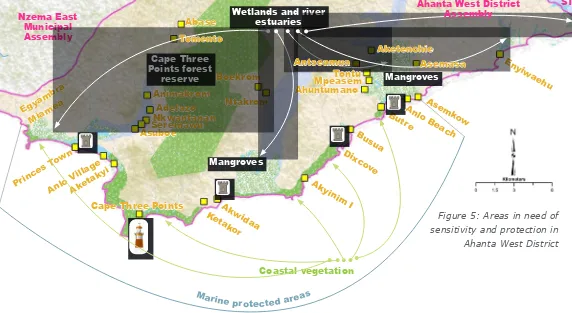
Figure 5: Areas in need of sensitivity and protection in Ahanta West District
Egyambr a
Mangroves
Wetlands and river estuaries
Marine protected areas Anlo
Ahanta West District Assembly
Princes Tow
n
3.3 Characteristics
of the Coastal Zone:
areas of restoration and
preservation
Wetlands, mangroves, lagoons, rivers and estuaries, provide essential ecosystem services and are also critical for maintaining
a healthy ishery (see section 3.4.2 below).
In Ahanta West, most of these resources are found on the coastal segment lying between Butre and Egyambra, forming a network of natural areas, which are a priority for conservation.
Ultimately, conservation of these resources could be extended to include nearshore areas to form a network of marine protected areas.
P4: Undertake public education on the
beneits of conservation of coastal
ecosystems.
P5: Work with Marine Protected Areas
Inter ministerial Committee over
designation of marine protected
areas.
Project
3.4 Relief, Drainage and Climate:
Coastal Dynamics, Human Uses and
Implications
3.4.1 Shoreline Beaches, Dunes and Barrier
Spits: human and natural hazards
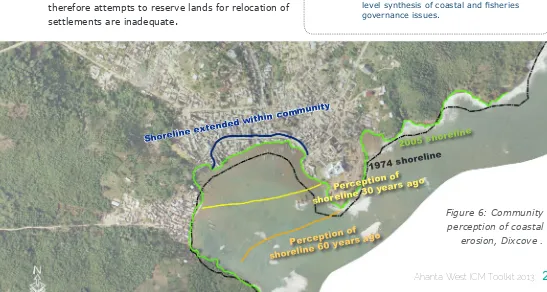
Due to rising sea level in recent decades, most barrier beaches in Ghana are retreating at a rate of about 1m per year and in the Western region, are estimated to be retreating at 2m per year on the average (2). Erosion, sea level rise, and sand winning from the beach can all result in land loss and the inland movement of the shoreline.
Sections of the shoreline in the district are noted to have eroded considerably over the past 50 years, causing the disappearance of buildings, farm lands and other properties. This phenomenon still continues due to high sea wave energy and sea level rise, exacerbated by Climate Change. In Busua for example, the whole shore line experienced massive erosion in 2007 due to heavy
seas and storms, which exposed laws in the sea defense
mechanism and destroyed properties of the beach resorts and hotels. In other communities, settlements, farm lands
and ish landing sites have been destroyed.
STMA
P6: Increase collaboration with the Ministry
of Water Resources, Works and Housing for
regulating private development and installing
publicly funded defenses.
P7: Where acceptance of land loss is agreed as
the best option long term, plan re-settlement
schemes and incorporate as objective in
Structure Plans.
P8: Develop a public education programme on
coastal hazards and climate change
P9: End destructive sand winning practices by
use of bye laws and community sensitisation
P10: Prepare coherent shoreline management
plans to regulate coastal land use.
R6: Report on Characterization of coastal
communities and shoreline environments in the
Western Region of Ghana.
This report provides information on the conditions and environmental, social and economic issues faced by 89 coastal communities in the six coastal districts of Ghana’s Western Region. Rapid appraisals of coastal communities, district level validation workshops and secondary literature review were undertaken to provide additional information that will ultimately contribute to assembling the baseline. While rapid appraisals gleaned community scale information, it also provided the opportunity to socialize the initiative among coastal communities visited. The purpose of district scale workshops was to solicit inputs from local
people as well as reactions to indings of
the rapid appraisals and to incorporate local perceptions of changes into a district
level synthesis of coastal and isheries
governance issues.
Project
Reference
Figure 6: Community perception of coastal erosion, Dixcove .
obstructing economic activities. Similar incidences
of coastal looding are noted in all the coastal
communities with varying impacts based on the elevations above sea level.
Stakeholders in the district have demonstrated varied knowledge of coastal erosion. In Funko, most women perceive that coconut trees are a driver for coastal erosion and argued that uprooting of the trees by tidal waves accelerates the erosion process; as such, they deliberately cut down coconut trees along the beach in their attempt to stop the erosion.
Again, isher folks in Funko dump old nets and other
waste at the shore in an attempt to stop or delay the erosion process. The situation can be made worse by improper planning and design.
Coastal erosion and perennial looding has
characterized communities where there has also been intense winning of beach sand and stone boulders. The construction sector relies heavily on coastal sand and pebbles. Over the period, a cartel of sand winners has evolved to supply construction materials to meet the high demand. In Adwoa and Funko,
residents have identiied sand winning as a driver
for the degrading shoreline but acknowledged the
dificulty in controlling the practice.
Several methods are being used by the Hydrological Services Division of the Ministry of Water Resources, Works and Housing to control shoreline erosion including the use of gabions and boulders. However, high energy waves, strong currents and periodic storms expose the weakness of these defense mechanisms. In many cases relocation is the only
real alternative, but accepting this is dificult, and
therefore attempts to reserve lands for relocation of settlements are inadequate.
Perception of shoreline 30 year
s ago
Good Management Practices
Support Urbanization, Sanitation and Wastewater
Management in the Coastal Zone:
3.4.2 River Estuaries,
Drainage Outlows, Mangroves,
Wetlands, Marshlands and
Coastal Lagoons
Wetlands and coastal water resources serve vital functions in the environment. They provide habitat for many plants and animals, including migratory
birds and many types of ish. Mangrove areas, in
particular, are important to the overall health of
the marine isheries, because they provide habitats for shellish as well as nursery grounds to juvenile ish. Mangrove wood is harvested for a variety of
purposes, but this practice should be limited due to the damage to wetlands that overharvesting causes.
From a hydrologic perspective, wetlands serve to dampen the effects of changing water levels,
thereby providing protection from looding. In the process of slowing loodwaters, wetlands trap and
store sediments, limiting erosion and in some cases actually building up soil. Through this process, they protect coastal waters from excessive runoff and sedimentation. Coastal communities often rely on these areas for their drinking supply, so maintaining
the low levels and cleanliness of the water is vital
to community health.
Wetlands are easy targets for dumping of waste and
inilling because they lack existing users or owners.
They are also under threat from indiscriminate
cutting of mangroves for ire wood for cooking and ish smoking. The practice is very common, partly
due to low level of awareness of their ecological functions and services.
For example, mangroves are regarded as free ‘gifts from God’, and therefore should be exploited without conservation. In Busia and Dixcove frequent
cutting of the mangroves for ish smoking, has
drastically degraded the wetland. Comparatively, in Butre and Akwidaa, the mangroves are in fairly good conditions due to interventions by NGOs like Ricerca and Cooperazione and Conservation Foundation, among others. In the communities where the wetlands are degraded from intense
mangrove cutting, residents claim ish landings are
rapidly dwindling.
R7: Rapid assessment of mangrove status and conditions
for use to assess potential for marine payment for
ecosystem services in Amanzule and surrounding areas in
the western coastal region of Ghana, West Africa
Ghana’s mangrove ecosystems are tremendously valuable, providing ecosystem services like carbon sequestration,protection from storms, loods, and erosion, provision of
timber and non-timber forest products, processing of waste and nutrient pollution, aquaculture and agriculture support, and habitat for aquatic and terrestrial species. Yet, as in many other parts of the world, short-term development needs are undermining long-term mangrove health and survival. Fortunately, economic mechanisms have the potential to tip the balance toward restoration, maintenance, and protection of mangrove forests. The need for proper valuation of mangrove ecosystem services underpins such mechanisms towards the establishment of any realistic payment for ecosystem services scheme in any given mangrove or wetland habitat.
R8: Coastal Hazards and Flooding Risk in Ghana’s Western Region
This issue brief highlights the key issues facing Ghana’sWestern Region in terms of coastal looding in low-lying areas
as well as shoreline erosion, and recommends policy options to improve public safety and reduce environmental impacts.
R9: Carbon Stocks And Soil Nutrient Dynamics In The
Swamp Forests Of The Amanzule Wetlands & Ankobra River Basin
The peat swamp forests of the Amanzule Wetlands and Ankobra River basin is a truly unique landscape. Threats to the swamp forest, while still minimal, may be mounting, particularly in the form of small-scale artisanal logging,
irewood harvesting, and conversion to food crops like
maize and cassava. As demonstrated by this study, these anthropogenic activities have a detrimental impact on the ecosystem’s ability to store and sequester carbon, as well as on biodiversity and nutrient dynamics. Therefore, conservation of this intriguing and rare landscape is crucial. While more
research is required, it is possible that carbon inance, in the
form of REDD+, soil carbon, or climate smart agriculture could form part of a dynamic conservation and livelihood strategy.
R10: Mapping and Modelling Mangrove and Peat Forests Dynamics in
the Great Amanzule Wetlands, Ghana
Ghana’s mangroves continue to reduce in health and coverage,
especially in areas outside the ive Ramsar designated sites in
the country. Moreover, the use of compensatory mechanisms in addressing the exploitation of coastal ecosystems and climate change mitigation is in its nascent stages in Ghana because of the uncertainties in their carbon stock estimates
Flooding not only results from storm surges, waves, increased rainfall, and damaged wetlands, but also from other human activities throughout the drainage area and shorefront. These include dams, creation of impervious surfaces (roads, car parks) where rain used to soak away, blockage of water courses. These activities are also carried out by growing populations whose space is being reduced even further by coastal erosion.
Good Management Practices
Reduce Impacts from Flooding and Erosion:
Akwidaa Case Study
P11: Establish new and support existing
Community Resource Management Areas
(CREMAs) to protect and enhance wetlands
P12: Designate both on shore, including
wetlands and mangroves, and maritime
preservation areas in Structure Plans and Local
Plans
P13: Incorporate policies in plans and bye
laws to reduce impact of dams, creation of
impervious surfaces in development and
blockage of water courses
P32: Undertake public education on values and
importance of wetland ecosystems
Project
district in the western region of Ghana, especially in the face of limited data. Three main remotely sensed
data were used in the study: a true color orthorectiied
digital aerial photo (AP); and two satellite data sources - RapidEye and Landsat Thematic Mapper (TM) imagery. Additional data were acquired through a participatory mapping exercise and a GPS survey. Other ancillary data like an existing land use/ land cover map of the area was used for the mapping.
R11: Biodiversity Threats Assessment for the Western Region of
Ghana.
This review of biodiversity threats in the coastal zone of the Western Region of Ghana covers both terrestrial and marine systems and includes maps and descriptions of important wetlands and habitats.
R12: Rapid Biodiversity Assessment on the Essei and Butuah
Lagoons and the Whin River Estuary in the Sekondi-Takoradi
metropolis of the Western Region of Ghana
This rapid Biodiversity Assessment on the Essei and Butuah Lagoons and the Whin River Estuary in the Sekondi-Takoradi metropolis of the Western Region of Ghana concludes that deplorable management,
ignorance or conlict of interest on the part of users has
led the wetlands onto a path of potentially irreversible destruction. A new type of coastal management thinking and practice are needed that takes into account Ghanaian economic, socio-cultural and environmental perspectives.
R13: Approved byelaws for wetland conservation in 4 areas
(Butre, Busua, Akwidaa, and Princes Town)
Cape Three Points – Princes Town CREMA Constitution and Resource Management Bye-law was amended to
include provisions that call for the development of management plans for CREMA wetlands. The revised bye-law was approved by the Assembly.
R14: Model Bye-laws for Coastal Management in Ghana:
Experiences from Shama District
Through Hen Mpoano-facilitated technical assessments, stakeholder engagements and participatory mapping exercises, model bye-laws
and policy statements for lood hazard mitigation,
shoreline and wetland management were formulated and approved by the district assembly.
R15: Assessment of Critical Coastal Habitats of the Western
Region, Ghana
This assessment of critical coastal habitats of the Western Region, Ghana ranks 20 coastal ecosystems and describes 10 of these in detail.
Busua Beach
3
s
ec
ti
o
n AHANT
A WEST D
ISTRI
C
T COA
ST
AL PR
O
FILE AND D
E
VEL
O
3.5 Vegetation, Flora, Tropical
The “Green Network” concept “connects forest andFoliage Forests, Wildlife
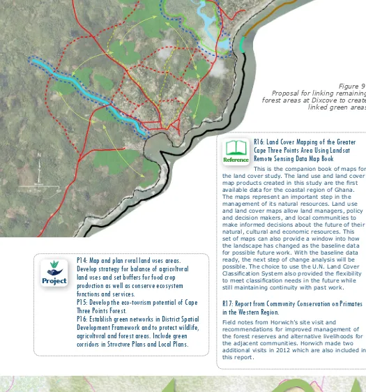
mountains to urban parks, farms and wetlands and down to small garden plots and street trees”.It will create unbroken “eco-corridors” with the
3.5.1 Coastal Vegetation, farming,
following objectives:forest reserves.
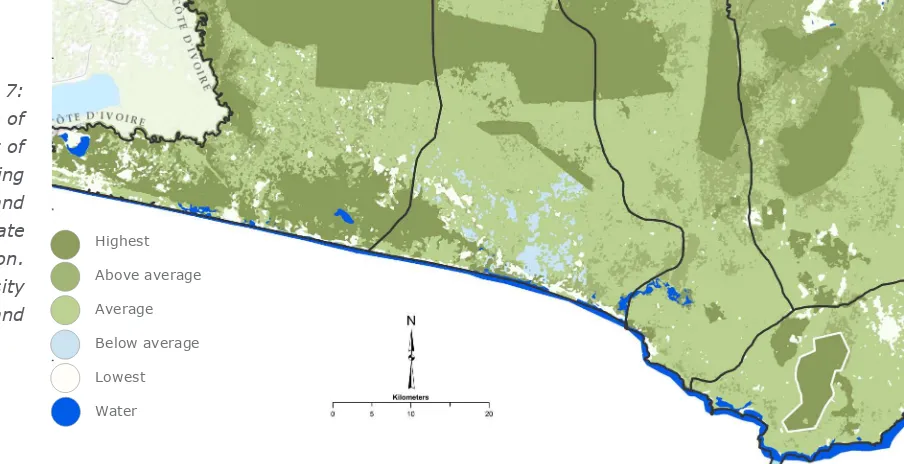
• Agricultural Lands: given that most of residents The current majority land use in Ahanta West are engaging in agriculture, the areas that are District is by subsistence farms, trees and not new development sites are designated as forest, palm oil and rubber plantations. Carbon greenbelt usable for agriculture, referring to sequestration capacities in Figure 7 illustrate the the balance within that, above.
extent of different types of use because they • Areas for protection of wildlife and biodiversity broadly equate with urban areas (crimson); farm will also be included.
crop areas (yellow); tree cover including oil palm • Coast and Forest: the west-east greenbelt (light green), rubber and forest (dark green). follows the coastline so that a “Trekking The Cape Three Points Forest Reserve is the only Route” can be developed to create value and major Forest Reserve in the District, and is one recreational activity in a way that it causes of the largest designated for ‘protection’ rather minimal impact on the environment.
than ’production’ in Ghana. It has the potential for • Protection and Extension of Cape Three Points: development as a visitor attraction, but is currently it is proposed to extend the natural forested being degraded by charcoal production, illegal southerly green belt at Cape Three Points all small scale mining, illegal logging, expansion of the way to coastal areas, while extending the the adjacent rubber plantations and of farming northerly end to Agona-Nkwanta.
by communities located around it. The mapping
of rural land uses and slope analysis will enable The Community Action Plan at Dixcove exempliies
decisions to be made about the most eficient how this issue is being ignored during urbanisation,
balance of uses. This designation of land for but that there are still opportunities to designate agriculture, added to protected areas/corridors for green corridors (see Figure 9). This should be done wildlife will enable the best decisions to be taken now before it is too late.
about areas for urbanisation, tourism, leisure and
industrial development. The need to promote and provide visitor access to
forest and subsistence lands in order to win over In this context, it has been proposed (3) that, public perception of the need to protect them is considering that even large areas of green also vital.
resources may be permanently destroyed through unplanned development, the concept of a “Green Network” will be a useful development planning
Highest Above average Average Below average Lowest Water
R16: Land Cover Mapping of the Greater
Cape Three Points Area Using Landsat
Remote Sensing Data Map Book
This is the companion book of maps for the land cover study. The land use and land cover
map products created in this study are the irst
available data for the coastal region of Ghana. The maps represent an important step in the management of its natural resources. Land use and land cover maps allow land managers, policy and decision makers, and local communities to make informed decisions about the future of their natural, cultural and economic resources. This set of maps can also provide a window into how the landscape has changed as the baseline data for possible future work. With the baseline data ready, the next step of change analysis will be possible. The choice to use the U.N. Land Cover
Classiication System also provided the lexibility to meet classiication needs in the future while
still maintaining continuity with past work.
R17: Report from Community Conservation on Primates
in the Western Region.
Field notes from Horwich’s site visit and recommendations for improved management of the forest reserves and alternative livelihoods for the adjacent communities. Horwich made two additional visits in 2012 which are also included in this report.
Figure 9: Proposal for linking remaining forest areas at Dixcove to create linked green areas
P14: Map and plan rural land uses areas.
Develop strategy for balance of agricultural
land uses and set buffers for food crop
production as well as conserve ecosystem
functions and services.
P15: Develop the eco-tourism potential of Cape
Three Points Forest.
P16: Establish green networks in District Spatial
Development Framework and to protect wildlife,
agricultural and forest areas. Include green
corridors in Structure Plans and Local Plans.
Project
Figure 8: Concept for a Green Network in Ahanta West District. Source: Korean International Cooperation Agency
3
s
ec
ti
o
n AHANT
A WEST D
ISTRI
C
T COA
ST
AL PR
O
FILE AND D
E
VEL
O
3.6 Settlements, Spatial
Analysis, Siting of
Infrastructure
3.6.1 Growth of the Coastal and
Fishing Settlements
The population of coastal settlements continues to increase strongly through natural growth from uncontrolled births, teenage pregnancy and
high immigration of isher folks (4). The coastal communities experience an inlux of itinerant boats and ishermen, particularly during the high ishing
seasons between July and September.
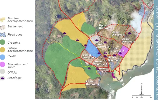
The natural growth of populations in existing impoverished coastal communities, which is substantial, will be met by in-migration of those more wealthy individuals who are seeing the potential of the coast for residential, leisure and new industrial development. Examples of the scale of urbanization can be seen in the scale of development which is emerging in Dixcove as shown in Figure 10 below.
3.6.2 Cultural context and traditions in
Coastal Communities
Artisanal ishing communities represent a
unique and distinct culture which arises from the activity. Fishermen are at sea in canoes for three to four days at a stretch, while others are
mending and making oats, nets and ishing gear. Women prepare, smoke and sell the ish. These
communities are predominantly of the Fante ethnic group. In population terms, Ahanta is the main ethnic group as well as the major language spoken in the district. Other languages spoken are Nzema, Evalue Nzema dialect and Fanti.
The paramount Chief of Ahanta traditional area is seated at Busua. Other key traditional rulers are seated at Upper and Lower Dixcove. The main festival in the District is Kundum, which is a major unifying force because it brings together families and people from within and outside the District. As noted above, chieftaincy disputes are a source of dis-unity and disorganization which hampers development in coastal communities.
3.6.3 Land ownership
Traditionally, land was in the “customary
ownership” of chiefs, who dispensed and allocated it on behalf of their people. Subsequently the colonial authorities negotiated treaties under Romano-British law, which led to individual land titles and leases being granted, and substantial land being taken into government ownership. Where most land is not registered, there are
frequent conlicts over its ownership. Families
who have subsisted on the land for generations are summarily evicted without compensation, and incoming investors are caught up in land disputes so that nothing materializes.
All of this requires that the land agencies should work more closely with local communities; that land transfers by chiefs should be transparent; and that adequate compensation systems are in place where families are dispossessed of their land by development. The land agencies currently operate in a very separate institution. By resolving this element, the implementation of integrated coastal management will become easier.
P33: Support local festivals and educate/
promote on retention of cultural identity of
coastal and ishing communities.
P34: Work with Lands Commission at local level on
land security and compensation
R19: ‘Faith In Action’ Faith Based Action For
Creation Care In Coastal Communities Of
Western Region.
This report details engagement with religious leaders in six coastal districts in the Western Region of Ghana from the 12th of December 2011 to the 9th of February 2012. In all, over 123 religious leaders were trained in reference theology on environmental stewardship and creation care. The programme led to the establishments of six interfaith eco-networks in six coastal districts in the western region of Ghana. The programme was a big success
and both participants and organisers beneitted
immensely from the exchanges and experiences shared. The main recommendations for keeping the
ire burning is ensuring that the eco-networks which
have been established live beyond the lifespan of the initiative to perform the functions of mobilising religious organisations and advocating for responsible coastal resource use.
Project
3.6.4 Spatial Analysis: Coastal
Settlements in Ahanta West
There are 123 communities in the district and out of which 22 are on the coast. The most populated areas in the District are on the N1 highway leading west out of Takoradi, and Dixcove, which was a former colonial settlement. The principle coastal settlements are, from east to west: New Amanful, Funko, Pumpuni, Adwoa, Enyiwaehu, Mpatano, Asemkow, Anlo Beach, Atakrom, Butre, Busua, Dixcove, Akinim, Akyonwa, Bebianiha, Akwidaa, Ketakor, Cape Three Points, Aketaku, Anlo Village, Princes Town, Miamea and Egyambra. As noted
above, the irst nine up to Atakrom, are becoming
part of the urbanization west of Takoradi. Butre, Busia and Dixcove comprise a growing tourism destination. From Dixcove to Princes Town through Akwidaa, and Cape Three Points up to Anlo Village are isolated and less likely to develop until the coastal road is built. Improved road links to the NI are planned, based on substantial leisure investments which are planned for the last two, Princes Town and Egyambra, which are more likely to become developed in the near future.
The area west of Takoradi is developing rapidly without any structure plan or local plans for the coastal zone yet being prepared. These are
Figure 10: Sketch draft Structure Plan for Dixcove | Source: CRC Ghana 2013 Upper
Working with the community at Dixcove, it quickly became apparent that the area of displacement and resettlement that had to be resolved with
the existing ishing and farming community was
only a small part of the area which is becoming earmarked for development. Dixcove and Busua are likely to become merged with Butre in the foreseeable future in one large conurbation.
In order for this to happen in a way which creates an orderly, modern town in which the existing
community and incomers both beneit from a
high quality environment, investment in social amenities, water, power, connecting roads, water courses needs to be made for the larger urban area which includes the existing area. This should
be able to be inanced by new investors if the
planning and permitting process aims for high quality, high values and negotiates sharing of improved land values.
The coastal communities from west of Dixcove to Cape Three Points and Anlo Village are less likely to receive capital investment until their infrastructure is improved, but measures can be taken to improve services and capacity for resilience. This stretch of coast is the location for a unique cluster of nine low-capital “eco-tourism”
Figure 11: Sketch draft structure plan for Akwidaa
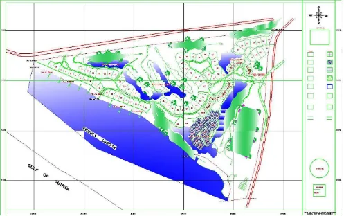
Figure 12: Masterplan proposals for Princes Town.
Pocket beach
River Delta
Rocky Headland
Barrier
beach/spit
(backed
by lagoon)
Beach, berm, dunes
FLOOD ING
Foo tbridge
Road to Cape Three Points
Road to Dixcove River rises with
heavy rain
Net Long s
hore current and sand movem
ent
Wetlands & mangroves SALT BRACKISH
FRESH
Turtle nesting beach
Waves that can cause erosion
Estuary Lagoon (tidal)
3.6.5 Siting of Infrastructure/
Settlements
It is essential that water dependent and water enhanced uses with resulting value returns are used to maximize value in areas of the coastal zone and that their siting prevents erosion and further damage to the coast (see, for example, location of proposed tourism development zone in Figure 10 above). To achieve this it will be necessary that the ground rules for shoreline development are included in the Structure Plan, Local Plans and through Assembly Bye-Laws.
3.6.6 Social issues, water, waste,
and sanitation
Coastal communities are experiencing a severe decline in their traditional livelihoods through both natural and man-made causes. Poverty levels are increasing, educational levels are declining rather than improving, population continues to rise through high birth rates including teenage pregnancies and declining parenting standards. These factors are evident in the Medium Term Development Plan for the District.
The improvement of water supply, collection
and inal disposal of waste are matters that
affect the health and quality of life of all coastal residents in the district. Streams and small rivers which serve many communities are the traditional sources of water for drinking and domestic use. Most communities also rely on boreholes and wells for their water. As these become polluted and demands on them increase, the need for investment in protection and new supplies arises. Added to community needs are those of the major industrial and tourism and leisure projects. These consume water on a much larger scale, yet the Water Resources planning for the region indicates the likelihood of a growing crisis gap between supply and demand. This is made worse by the pollution from mining of the region’s major rivers and water courses.
Shoreline sanitation, especially at the densely
populated ishing communities, requires
more attention due to the implications on
hygienic handling and processing of ish. It is common to ind disposed fecal matter
resorts (5), which can be seen in a positive light, and protected, as the seeds of eco-friendly development on the coast.
The input of major capital investment into leisure and
other activities is exempliied by proposals for Princes
Town involving a high quality hotel, residential and golf course development around the lagoon (6) and
adjacent to the historic fort and ishing community.
The issues arising from this are typical of any regeneration/investment project on this scale in the coastal zone.
P16: Prepare Structure Plans and Local Plans for
areas west of Takoradi up to Butre estuary and
Agona; also Butre/Busia/Dixcove area.
P17: Prepare Community Action Plans to address
vulnerability and improve resilience for all
coastal communities by building on Dixcove and
Akwidaa vulnerability assessments
P18: Apply good coastal management practice
in major leisure developments such as Princes
Town.
Project
Good Management Practices
to Support Manage Large-Scale Leisure
Development to Beneit the Community, the
Private Investor and the Ecosystem:
Princes Town Case Study
Case
study
R20: A Climate Change and Natural Hazards
Vulnerability Assessment and Adaptation Plan for
Dixcove, Ahanta West District.
This is an initial Coastal Resilience Plan for Dixcove which aims to make the coastal community more resilient (less vulnerable) in the short, medium and long term. It provides an overview of the planning context and describes the key coastal features and their physical characteristics. A vulnerability assessment based on this information, focusing on the adaptive capacity in key facets including economic, social, governance and physical. A set of short and longer term actions are
identiied in conjunction with the community to improve
its adaptive capacity and strengthen overall resilience.
R21: A Climate Change and Natural Hazards Vulnerability
Assessment and Adaptation Plan for Akwidaa and Ezile Bay,
Ahanta West District.
This is an initial Coastal Resilience Plan for Akwidaa and Ezile Bay which aims to make the coastal community more resilient (less vulnerable) in the short, medium and long term. It provides an overview of the planning context and describes the key coastal features and their physical characteristics. It is a vulnerability assessment based on this information, focusing on the adaptive capacity in key facets including economic, social, governance and physical. A set of short and longer term
actions are identiied in conjunction with the community
washed ashore directly to the ish landing sites and the beaches, contaminating the ish that is
harvested. Efforts made by Zoomlion and Zoil have
produced no signiicant change in the sanitation
condition. Improving sanitary services in the coastal communities is necessary for the following reasons:
1. Eliminate the causative agents of those water and excreta-related diseases; convert waste into readily re-usable resources and so conserve both water and nutrients; prevent the pollution of any body of water (ground water or surface water)
to which the efluent escapes or into which it
is discharged; to reduce organic pollution of water for drinking and other domestic purposes;
P19: Map critical watersheds shared
by adjoining districts and subject to
collaborative management
P20: Continue and extend coastal and
shoreline waste management schemes
P21: Reinstatement of wells and
boreholes to be conditions of new
developments and take account of
salination threats
R22: Opportunities for integrating family
planning, health and nutrition interventions
into coastal-isheries governance agendas in
Western Region, Ghana
Opportunities for integrating family planning, health
and nutrition interventions into coastal-isheries governance agendas are identiied for the coastal
districts of Ghana’s Western Region.
R23: Facilitating Integrated Population Health and
Environment in Five Communities in the Shama District and
Two Communities in the Ahanta West District: Achievements
and Lessons Learned
This report outlines the accomplishments and lessons learned through the implementation of integrated Population, Health and Environment (PHE) initiatives by the Central and Western Fishmongers Improvement Association (CEWEFIA) in seven coastal communities in Ghana’s Western Region. The report elaborates on the socio-environmental context in the communities before the piloted interventions and the relevance of PHE as an approach for addressing the issues faced by the target communities and associated ecosystems. The way forward for improving PHE programmes in such communities is
Project
suggested to inform similar actions in other parts of the country and elsewhere in the world.
R24: Freshwater supply and distribution: a developing crisis
in the Western Region
This issue brief highlights the key issues facing Ghana’s Western Region in terms of fresh water supply and distribution and recommends policy options to protect water resources and insure equity in their use and distribution.
R25: Improving Livelihoods through Plastic Waste
Management in Coastal Communities of the Western Region
of Ghana: Achievements and Lessons Learned
This report outlines the accomplishments and lessons learned through piloting integrated sanitation and livelihood improvement interventions in four coastal communities in the Western Region of Ghana by Daasgift Quality Foundation. It highlights the issues of plastic waste management in coastal communities and describes the business model applied to facilitate household income generation through plastic waste management in the target communities. The way forward for improving plastic waste management in coastal communities is suggested to inform similar and future initiatives in other parts of the country.
safeguard aquatic life and maintain a healthy ecology of surrounding communities,