The Integrated Coastal and Fisheries
Governance (ICFG) Program for the
Western Region of Ghana
Phase 2 Strategy and Year 2
Semi-Annual Report
2011
October, 2010 – March, 2011.
THE
UNIVERSITY of Rhode Island GRADUATE SCHOOL OF OCEANOGRAPHY
Coastal Resources
This publication is available electronically on the Coastal Resources Center’s website at
http://www.crc.uri.edu
For additional information on partner activities:
WorldFish: http://www.worldfishcenter.org
Friends of the Nation: http://www.fonghana.org Hen Mpoano: http://www.henmpoano.org Sustainametrix: http://www.sustainametrix.com
For more information on the Integrated Coastal and Fisheries Governance project, contact: Coastal Resources Center, University of Rhode Island, Narragansett Bay Campus, 220 South Ferry Road, Narragansett, Rhode Island 02882, USA. Brian Crawford, Director International Programs at [email protected]; Tel: 401-874-6224; Fax: 401-874-6920.
Citation: Coastal Resources Center. (2011). The Integrated Coastal and Fisheries Governance
(ICFG) Program for the Western Region of Ghana., Phase 2 Strategy and Year 2 Semi-Annual Report, October 2010 – March, 2011. Narragansett, RI: Coastal Resources Center, Graduate School of Oceanography, University of Rhode Island. PW005. 85 pp.
Disclaimer: This publication is made possible by the generous support of the American people
Integrated Coastal and Fisheries Governance (ICFG)
Initiative for the Western Region of Ghana
H
Ɛ
N MPOANO (OUR COAST)
Semi-Annual Report
October 1, 2010 – March 30, 2011
Cooperative Agreement No. 641-A-00-09-00036-00
April 2011
Integrated Coastal and Fisheries Governance (ICFG)
Initiative for the Western Region of Ghana
H
Ɛ
N MPOANO (OUR COAST)
Semi-Annual Report
October 1, 2010 – March 30, 2011
Cooperative Agreement No. 641-A-00-09-00036-00
ii This publication is available electronically on the Coastal Resources Center’s website at
http://www.crc.uri.edu
For more information contact: Coastal Resources Center, University of Rhode Island,
Narragansett Bay Campus, South Ferry Road, Narragansett, Rhode Island 02882, USA. Brian Crawford, Director International Programs at Email: [email protected]; Tel: 401-874-6224; Fax: 401-874-6920
Citation: CRC 2011. Semi-Annual Report. Coastal Resources Center, University of Rhode Island. USAID Integrated Coastal and Fisheries Governance Initiative for the Western Region, Ghana. 71p.
Disclaimer: This publication is made possible by the generous support of the American people through the United States Agency for International Development (USAID)/Ghana. The contents of this report are the responsibility of the Integrated Coastal and Fisheries Governance (ICFG) Program and do not necessarily reflect the views of the United States Government. Associate Cooperative Agreement No. 641-A-00-09-00036-00 for “Integrated Coastal and Fisheries Governance (ICFG) Program for the Western Region of Ghana”, Under the Leader with Associates Award No. EPP-A-00-04-00014-00.
Cover Photo: AlgalBloom in the Nets of Fishermen in the Western Region Ghana
iii The Integrated Coastal and Fisheries Governance (ICFG) Program
for the Western Region of Ghana
Semi-Annual Report October 2010 – March 2011
Cooperative Agreement No. 641-A-00-09-00036-00
Coastal Resources Center, University of Rhode Island
In partnership with:
The Government of Ghana Friends of the Nation
SustainaMetrix The WorldFish Center
iv List of Resource Persons
CRC-GHANA
Mark Fenn
CRC-Ghana Program Director (Chief of Party)
Tel: +233 (0) 543 694 966 Email: [email protected]
Kofi Agbogah
National Program Coordinator (Deputy Chief of Party) CRC-Ghana
Tel: +233 (0)244 678 007 Email: [email protected]
CRC/URI
Cindy Moreau Business Manager
Coastal Resources Center, URI Tel: 401-874-6488
Fax: 401-789-4670
Email: [email protected]
Brian Crawford
Director, International Programs Coastal Resources Center, URI Tel: 401-874-6225
Fax: 401-789-4670 Email: [email protected] Web: www.crc.uri.edu
FRIENDS OF THE NATION
DonKris Mevuta Executive Director
Friends of the Nation –Ghana Tel: +233 (0) 244 520 686
Email: [email protected] WORLDFISH CENTRE
v SUSTAINAMATRIX
Glenn Page SustainaMetrix
Tel: + 1 443 604 6812 Email: [email protected]
USAID
Allen Fleming
Agreement Officer Technical Representative (AOTR). United States Agency for International Development/ Ghana Tel: + 233 (0)302 741 320
Email: [email protected]
Nino Nadiradze Alternate AOTR USAID/Ghana
Cell: +233 (0) 741322 E-mail: [email protected]
Justice Odoi
Environment Specialist U.S. Agency for International Development/Ghana
Tel: +233 (0)302 741828 Email: [email protected]
Jennifer Crow-Yang Regional Agreement Officer Tel: +233 (0)302 741272 Email: [email protected]
Frederique Rakotoarivelo (Accra/WA/RAAO)
Tel: 0302 742720
vi List of Acronyms
ACDI/VOCA Agricultural Cooperative Development International/Volunteers in
Overseas Assistance
ADVANCE Agricultural Development and Value Chain Enhancement
BALANCED
Building Actors for Livelihoods and Advancing Communities Excellence in Development
BCS Behavior Change Support
CBAG Community Based Advisory Groups
CBD Community Based Distributors
CHW
CEWEFIA
Community Health Workers
Central and Western Region Fishmongers Improvement Association
COSPE Co-Operation for the Development Of Emerging Countries
CRC Coastal Resources Center
CREMA Community Resource Management Area
CSOs Civil Society Organizations
CSR Corporate Social Responsibility
DCEs District Chief Executives
DP Development Partners
ECHNTS Essiama Community Health Nurses Training School
EPA Environmental Protection Agency
FiC Fisheries Commission
FP Family Planning
FtF Feed the Future
FWG Fisheries Working Group
GIS Geographic Information System
GOG Government Of Ghana
GSBA Globally Significant Biodiversity Area
GSO Graduate School of Oceanography
IBA Important Bird Area
ICFG Integrated Coastal and Fisheries Governance
ICM Integrated Coastal Management
IEC Information Education and Communication
IEHA Initiative to End Hunger in Africa
ILGS Institute Of Local Government Studies
vii
LCA Leadership for Conservation in Africa
LI Legislative Instrument
LOGODEP Local Government and Decentralization Program
M&E Monitoring and Evaluation
MCS Monitoring Control and Surveillance
MEST Ministry of Environment Science and Technology
MFRD Marine Fisheries Research Division
MOFA Ministry of Food and Agriculture
MPAs Marine Protected Area
MPs Members of Parliament
NGO Non Governmental Organization
NORAD Norwegian Agency for Development Cooperation
NSV National Service Volunteers
ONR Office of Naval Research
PEs Peer Educators
PHE Population Health and Environment
PMP Performance Monitoring Plan
RCH Reproductive and Child Health
REDD Reducing Emissions From Deforestation And Forest Degradation
RRA Rapid Rural Appraisal
SO Strategic Objective
STMA Sekondi- Takoradi Metropolitan Assembly
TBD To Be Determined
ToR Terms of Reference
UCC University of Cape Coast
URI University of Rhode Island
USA United States of America
USAID United States Agency for International Development
USG United States Government
WAPCA West Africa Primate Conservation Association
WERENGO Western Region Network of NGOs
WR Western Region
viii Table of Contents
List of Resource Persons ... iv
List of Acronyms... vi
Executive Summary... x
Executive Summary... x
1.0 Introduction... 1
1.1 Geographic Area of Focus ... 1
1.2 The Project Goal and Results Framework ... 1
1.3 Hİn Mpoano’s Contribution to Feed the Future ... 4
The Importance of Fisheries in Ghana’s Food Security ... 4
Project Activities in Relation to the Ghana FtF Results Framework... 5
1.4 Hİn Mpoano’s Contribution to Biodiversity Conservation in Ghana... 6
Areas of Biological Significance ... 6
Threats to Biodiversity ... 7
How the Project is Addressing these Threats ... 7
1.5 How the Project is Monitoring Progress on Addressing Biodiversity and FtF Objectives8 1.6 Overview of Year 2... 8
2.0 Program Activities ... 10
2.1 Component 1: Develop and Formalize a Nested Governance System for the... 10
Coastal Zone of the Western Region ... 10
2.1.1 Activity 1.1. Coordination of Activities and Assessment of GO ... 10
2.1.2 Activity 1.2 Assessment of Legal/Institutional Options for a NCGS... 12
2.1.3 Activity 1.3 Fisheries Working Group for the Western Region ... 12
2.2 Component 2: Improved Governance of the Landscape... 14
2.2.1 Activity 2.1 Landscape Planning and Management in Three Focal Areas... 14
2.2.2 Activity 2.2 Land Use Management at the District Scale ... 23
2.2.3 Activity 2.3 Enhancing Livelihoods and Social Conditions... 24
2.2.4 Activity 2.4: Value Chain Analysis of selected fisheries commodities... 33
2.3 Component 3: Governance of the Seascape... 34
2.3.1 Activity 3.1: Capacity Development for Best Practices in the GoF ... 34
2.3.2 Activity 3.2: Strengthening the information base for improved fisheries mgt. ... 35
2.3.3 Activity 3.3: Strengthening Capacity for Fisheries Compliance and Enforcement37 2.3.4 Activity 3.4: Marine Protected Areas (MPAs) ... 40
2.3.5 Activity 3.5: Water Quality Issues in the Fishing Grounds... 41
2.4 Component 4: Capacity Building... 44
2.4.1 Activity 4.1 Training ... 44
2.4.2 Activity 4.2: Communication Strategy ... 46
2.5 Component 5: Monitoring and Evaluation... 50
3.0 Challenges, Constraints and Measures Adopted ... 51
3.1 Diverse Spatial Planning Support Programs for Coastal Districts... 51
3.2 Study Tours to the Ivory Coast ... 52
3.3 Illegal (Galamsey) Mining ... 52
Annex 1. Program Results Area in Relation to USAID Strategic Objectives ... 53
ix
Annex 3: BC for the Process of Establishing a NGP for the CZ of the WR (1st Order) ... 60
Annex 4: Progress on the Five Component Activities for FY11... 67
List of Figures Figure 1: Map of the six coastal districts in the Western Region of Ghana ... 1
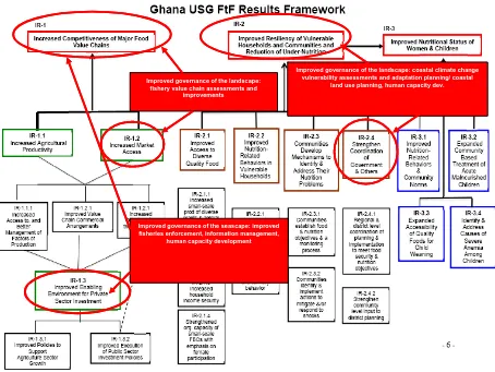
Figure 2: Hİn Mpoano Results Framework in relation to USAID Program Objectives ... 2
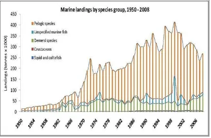
Figure 3: Fish landings by species group, 1950-2008 ... 4
Figure 4: Landings of Sardines (small pelagic) 1968-2010... 5
Figure 5: USAID FtF Results Framework in Relation to Hİn Mpoano Program Elements ... 6
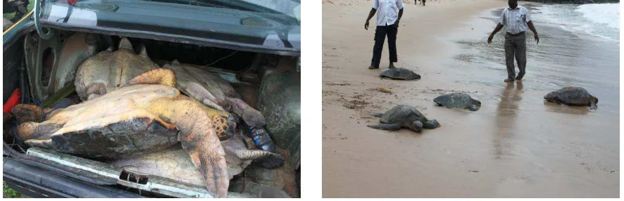
Figure 6: Illegally caught live turtles in the trunk of a Taxi ... 8
Figure 7:Rescued turtles released to sea near Cape Three Points ... 8
Figure 8: Map of the three wetlands in the Sekondi Takoradi Metropolis... 11
Figure 9: Map of Shama showing the Pra river estuary, built-up area and the coastline ... 15
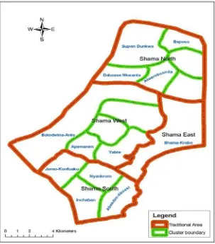
Figure 10: Map of Traditional Areas and Community Clusters ... 16
Figure 11: Maps generated through participatory mapping and visioning process in Shama... 18
Figure 12: Map of Cape Three Points Forest Reserve and fringe communities... 21
Figure 13: Map of the Amanzure Lagoon and associated wetlands in the ... 23
Figure 14: A semi-enclosed improved chicken housing for a Small Grants beneficiary ... 29
Figure 15: A grant recipient Grace Dadson ... 29
Figure 16: Peer Educators at Shama ... 30
Figure 17: Training session on compliance and enforcement ... 38
Figure 18: Algae deposits near the Ankobra river Estuary... 43
Figure 19: Task Force members inspecting the onset of the algal bloom ... 43
Figure 20: Back covers of the ‘Our Coast Document and Newsletter ... 47
x
Executive Summary
The Integrated Coastal and Fisheries Governance (ICFG) Initiative is a four-year (2009-2013) U.S. Agency for International Development (USAID) supported Program in Ghana with funding is from the United States Congress Food Security (Feed the Future) and Biodiversity Earmarks. The Program is implemented through a cooperative agreement with the Coastal Resources Center (CRC) University of Rhode Island (URI), USA. Key partners are the WorldFish Center,
SustainaMetrix and Friends of the Nation.
Program activities have been concentrated in six coastal districts of the Western Region where coastal communities and their local governments are the intended primary beneficiaries. Given the nature of some of the issues and the scale at which they need to be addressed, the program also links local actions with national programs as well.
In Year 1 or Phase 1 (2009-2010), a series of studies and field based assessments culminated in the publication of the “Our Coast” document. This document communicates the evolution of ecosystem change and ecosystem governance at both the sea and landscapes in the 6 districts. The document presents a way forward and outlines what the ICFG Initiative seeks to accomplish in Years 2 to 4. The document which was launched in Accra and Takoradi in March 2011 has been widely distributed throughout the coastal zone of Ghana.
The first six months of Year 2 of the ICFG or Hεn Mpoano1 Initiative saw the implementation of activities towards achieving the planned objectives. The activities focused on capacity building and training for Program Staff and key partners on Integrated Coastal Management (ICM) planning to address the critical issues identified in Phase I. A total of 58 Civil Society
Organizations (CSOs) and government agencies (48 CSOs and 10 government agencies) received capacity building and training support (Indicator 3) (see Annex 2 for details on the Program Indicators). The number of individual stakeholders from local communities participating in capacity building and resource management initiatives was 516 people, of which 83 were females (Indicator 4). Finally, the number of government personnel, community leaders, and private sector stakeholders trained was 260 of which 89 were females. The investments in capacity building have greatly enhanced engagement at all levels and have bolstered a growing sense of local ownership of the Hİn Mpoano “brand” of thinking and action, or constituency building (a major part of the First Order Outcome for enabling conditions).
For Phase II, three focal land and seascape areas were identified as priorities for both biodiversity and food security as well as for developing models for integrated coastal zone planning. They are the Shama District, the Greater Cape Three Points Area and the Greater Amansuri Wetlands. During this reporting period, activities have focused Shama and Cape Three Points. A demand driven participatory spatial planning exercise in the Shama District yielded exciting results and generated enthusiasm both within and outside the District. The Shama District process has become a model for participation and training of local government (district) personnel as well as traditional leaders, elected district assembly representatives and community members. The exercise has also contributed to behavior change and pro-active actions for communities and districts vulnerable to the effects of climate change, notably flooding and shoreline erosion.
1
xi The ongoing profiling of the critical issues in the Shama District has also enlightened leaders as to the most pertinent priority area that local government needs to address together with other partners. This process has also involved collaboration with the Geography and Regional Planning Department of the University of Cape Coast and has already influenced the Department’s
technical training programs. As other donor supported programs have shown interest and committed funding to support and complete Spatial Planning in the District, Hİn Mpoano will focus its support to the District to address the critical coastal issues of seashore erosion, flooding and coastal wetlands degradation.
Progress on the Greater Cape Three Points focal area included stakeholder consultations that have led to the creation of a working group that has begun addressing issues of uncontrolled access into the Cape Three Points Forest Reserve. This forest is the last remaining coastal rainforest in West Africa and is of critical importance for conservation of two rare primates and several bird species. The working group has begun the revision of the management plan of the forest reserve (Indicator 2) that will include community co-management of the forest and peripheral areas. Community awareness and patrolling actions have resulted in a decline of some of the flagrant illegal activities of artisanal mining and logging. Thus we can say that the 5100 hectares of forest reserve are already under improved management (Indicator 6).
Feasibility and reconnaissance studies for a future Marine Protected Area (MPA) covering critical wetlands areas and marine habitats - east and west of Cape Three Points and contiguous to the forest reserve have begun. The Hİn Mpoano Initiative is playing a lead role in supporting an inter-ministerial committee that is identifying modalities (process and institutional) for establishing and managing MPAs in the future.
Management planning for the three urban wetlands (240 hectares in the Sekondi-Takoradi Metropolitan Area ( STMA) as well as future community managed wetland areas where local NGOs have been provided grants for conservation initiatives (6000 hectares) are advancing and many of the NGOs will be provided with follow-up grants to continue these programs. The Department of Fisheries and Aquatic Sciences of the University of Cape Coast has begun a collaborative program to develop educational and participatory monitoring with schools and communities adjacent to 10 priority wetland sites. One of these sites is the third focal area of the Greater Amansuri Wetlands. Preliminary meetings have been held with local conservation NGOs and traditional leaders to discuss scenarios for establishing a community managed protected area for the Amansuri area.
A collaborative agreement has been reached with Forest Trends (US based NGO) to identifying opportunities and completing feasibility studies for long-term funding for this large wetland area either through carbon sequestrations schemes (REDD or voluntary) or biodiversity offsets. Scenarios for formalized conservation status for the Amansuri wetlands and over 10 other wetlands areas will be based upon district by-laws presently being developed for the three urban wetlands in the STMA. These wetlands are of critical importance for biodiversity conservation and buffering the effects of climate change.
xii actions ultimately contribute to a fisheries sector plan that aims to maintain and restore the fisheries which is an essential element of food security for the country.
Innovative data collection programs are being piloted by the WorldFish Center with the use of 10 National Service Volunteers spread across the six districts. The data on fisheries effort has already provided useful insights into how fisher folk make decisions. Catch data is revealing information on ecological trends in the fisheries that will orient strategies for managed fisheries in the near future. The WorldFish Center led a “value chain” study in order to identify where market and process interventions could improve both quality and economic returns for local livelihoods.
Essential support to the Fisheries Commission to promote the new Fisheries Regulations included several forums for communicating the regulations and discussing means for promoting
compliance. In addition, workshops were organized for the various agencies responsible for enforcement to render more efficient the prosecution of flagrant violations of the Regulations. A Fisheries Sector Working Group, comprising pertinent stakeholder groups has been created in the Western Region with the benediction of the Fisheries Commission. This “group” has already been instrumental in communicating the ecological justifications for the new fisheries regulations and in defusing several emerging conflicts resulting from them.
A critical action, relative to addressing evolving food insecurity in the Ellembelle and Jomoro Districts has been CRC’s instrumental role in awakening the national conscience on the “green-green” algae bloom problem and leading scientific to determine the source and drivers of the marine algae bloom which has plagued the two coastal districts for nearly two decades. To this end, a national task force (which includes representation from CRC) has been established by the Honorable Minister of Environment Science and Technology to consider study the impacts of the bloom on the coastal communities in the two districts and recommend possible interventions by the Government of Ghana. CRC has also facilitated the start of a research program that will identify the cause or origins of the bloom with researchers from the University of Rhodes Island and the US Environmental Protection Agency. Early indications, coming from assessments of the nitrogen isotopes, point to sources from municipal sewage drifting from the Ivory Coast (as compared to agricultural or industrial pollutants or the natural marine upwelling). CRC initiated a collaborative research with colleagues in the Ivory Coast but the process has been stalled by the political situation on that country.
Several programs aimed at improving social conditions and diversifying livelihoods which contribute to food security objectives have been developed. Most noteworthy are the Hİn Mpoano Small Grants scheme that provided several grants for promising actions in diversified revenue to families in fishing communities and a pilot “population-health-environment” (PHE) program that extends family planning extension and nutritional education programs to rural communities through a local NGO (CEWEFIA). The PHE program is supported by the USAID funded “BALANCED” program to CRC that operates in several countries worldwide.
xiii USAID funded health and governance programs in the Western Region, notably LOGODEP and the Behavior Change Support (BCS) Program.
To date, the Initiative has a few early success stories that are highlighted in the report. However, there have been some constraints in program implementation, notably, that of a diversity of actors with support programs for spatial planning in the Districts, postponement of the planned study and exchange trips to the Ivory Coast (due to the unstable political situation), and an increase in illegal mining activities in river valleys. Measures for addressing these constraints have been identified and are discussed in detail.
1
1.0 Introduction
The Integrated Coastal and Fisheries Governance (ICFG) Program is a four-year (2009-2013) Initiative supported by the U.S. Agency for International Development (USAID). It is
implemented through a cooperative agreement with the Coastal Resources Center (CRC) University of Rhode Island (URI). Key partners include the WorldFish Center, SustainaMetrix, Friends of the Nation, the Fisheries Commission, coastal districts in the Western Region and other key government, private sector and civil society groups along the coast.
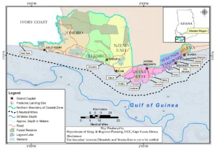
1.1 Geographic Area of Focus
Program activities have been concentrated in six coastal districts (Figure 1) of the Western Region, where coastal communities and their local governments are the intended primary beneficiaries. Given the nature of some of the issues and the scale at which they need to be addressed, the Program links local actions with national initiatives as well.
Figure 1: Map of the six coastal districts in the Western Region of Ghana
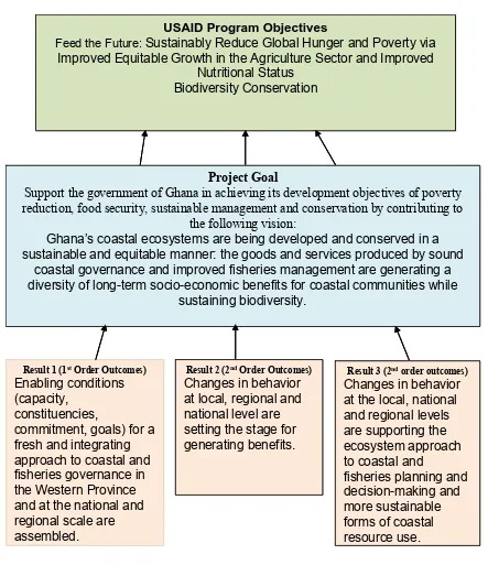
1.2 The Project Goal and Results Framework
2
Ghana’s coastal and marine ecosystems are sustainably managed to provide goods and services that generate long term socio-economic benefits to communities while sustaining biodiversity.
Project Goal
Support the government of Ghana in achieving its development objectives of poverty reduction, food security, sustainable management and conservation by contributing to
the following vision:
Ghana’s coastal ecosystems are being developed and conserved in a sustainable and equitable manner: the goods and services produced by sound
coastal governance and improved fisheries management are generating a diversity of long-term socio-economic benefits for coastal communities while
sustaining biodiversity.
Result 1 (1stOrder Outcomes) Enabling conditions (capacity,
constituencies,
commitment, goals) for a fresh and integrating approach to coastal and fisheries governance in the Western Province and at the national and regional scale are assembled.
Result 2 (2ndOrder Outcomes) Changes in behavior at local, regional and national level are setting the stage for generating benefits.
Result 3 (2ndorder outcomes) Changes in behavior at the local, national and regional levels
Feed the Future: Sustainably Reduce Global Hunger and Poverty via
Improved Equitable Growth in the Agriculture Sector and Improved Nutritional Status
Biodiversity Conservation
Figure 2: Hİn Mpoano Results Framework in relation to USAID Program Objectives
3
• critical food security (Feed the Future-FtF) challenges of improving the governance and management of the fisheries and fisheries value chains (Feed the Future Initiative’s goal to Sustainably Reduce Global Poverty and Hunger - see Fig. 3) and
• biodiversity conservation through sustained management of marine and coastal resources based on the USAID biodiversity code criteria.
Also, the Program addresses several cross cutting themes on gender, decentralization, public-private partnerships and empowering Ghanaians (See Annex 1 for details). Monitoring of program activities is based on baseline conditions as they relate to the Orders of Outcomes framework (articulated in Box below) as well as a number of standard USAID FtF and biodiversity indicators (see Annex 2).
Orders of Outcome Framework
The Orders of Outcomes is our results framework and development hypotheses which disaggregate the goal of the program into a sequence of more tangible outcomes. The 1st
Order Outcomes define four enabling conditions while 2ndOrder Outcomes are measured by
changes in the behavior of governmental institutions, relevant groups exploiting or otherwise affecting ecosystem conditions; and of those making financial investments in the system. The 3rdOrder marks the achievement of the specific societal and environmental quality goals that
prompted the entire effort. The achievement of a sequence of 3rd Order goals marks the path
to the sustainable forms of development that are defined as the 4thOrder.
1st Order Outcomes will be the major emphasis of the Program in the first four years.
Result 1:Enabling conditions for an integrated approach to coastal and fisheries governance in the Western Region and at the national and regional scales are assembled. (This result area defines targets on issues of local, national and regional governance, policy reform and communication, and private partnerships and alliances).
2nd Order Outcomesare possible as expressed in the following two result areas once a sufficient threshold of enabling conditions are achieved:
Result 2:Changes in behavior at local, regional and national level are setting the stage for generating benefits.
Result 3: Changes in behavior at the local, national and regional levels are supporting the ecosystem approach to coastal and fisheries planning and decision-making and more sustainable forms of coastal resource use.
4
1.3 Hεn Mpoano’s Contribution to Feed the Future
The Importance of Fisheries in Ghana’s Food Security
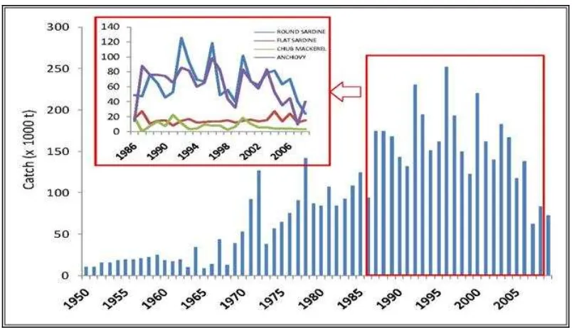
Fish protein is an important constituent (60%) of animal protein in the diet of Ghanaians and more importantly the fisheries sector contributes about 4.5 % to agricultural GDP. The marine resources which include many pelagic and demersal fishes of which sardinellas (sustained by the rich upwelling ocean system of the Gulf of Guinea) are the mainstay of the fisheries of the coastal people, providing more than 2.5 million Ghanaians (10% of population) with livelihoods. Equally important is the fact that much of the fish caught in Ghana’s marine waters is smoked, dried and transported long distances to the Northern areas of the country as well as to other sub-Saharan countries in the region where it provides an essential high quality food protein to these inland populations.
A Fisheries Sector Review of Ghana (carried out as part of the Year I activities) suggests a fisheries in crises. Figures 3 and 4 below show a general decline in landings over the past decade, particularly in many of the lower value small pelagic species that are a main food protein source for coastal communities, northern regions of Ghana and other Sahel countries as well. The main cause of this situation is poor governance of the fishery that has resulted in a dramatic increase in fishing effort over the last decade of the small-scale canoe and commercial fishing fleets. Government fuel subsidies to the canoe sector have exacerbated this situation.
5
Figure 4: Landings of Sardines (small pelagic) 1968-2010
Most of Ghana’s marine fisheries are now considered overexploited, more simply put – too many fishermen chasing too few fish. Without improved governance of the fishery, this situation is likely to get worse with lower levels of cheap fish protein supplied domestically to some of those most in need – poor rural fishing and farming households in Ghana. Further exacerbating these problems will be the impacts of climate change on the coastal zone – where sea level rise is threatening to inundate much of the land-based fisheries infrastructure that supports harvesting, processing and settlement areas for the tens of thousands of fishing households dependent on this resource.
Project Activities in Relation to the Ghana FtF Results Framework
Figure 5 shows the USAID mission results framework for the Feed the Future initiative and how key project activity components contribute to intermediate result areas of the USAID FtF
6
Improved governance of the landscape: coastal climate change vulnerability assessments and adaptation planning/ coastal
land use planning, human capacity dev.
Improved governance of the seascape: improved fisheries enforcement, information management,
human capacity development Improved governance of the landscape:
fishery value chain assessments and improvements
Figure 5: USAID FtF Results Framework in Relation to Hİn Mpoano Program Elements
1.4 Hεn Mpoano’s Contribution to Biodiversity Conservation in Ghana Areas of Biological Significance
7
Threats to Biodiversity
A number of studies were carried out during Phase I (Year I) of the project which identified threats to the biodiversity assets of the coastal areas of the Western Region and provided baseline environmental information on their current status and conditions. The studies included:
• Biodiversity Threats Assessment of the Western Region • Assessment of Critical Coastal Habitats of the Western Region
• Rapid Biodiversity Assessment of Three Urban Wetlands of the STMA
• Assessment of Local Knowledge of Fishing Grounds and critical habitats in the Nzema East and Ahanta West Districts
The major threats to biodiversity were identified as:
• Over-exploitation of marine fisheries resources including use of destructive fishing practices
• Loss of coastal habitat (due to destruction of wetlands)
• Pollution of the marine and coastal environment from land based sources - enriching coastal waters with nutrients (leading to blooms of marine green algae)
• Climate change impacts
• Weak governance, legislation and institutional framework, and lack of political will to enforce legislation
• Development of offshore oil and gas resources
How the Project is Addressing these Threats
Activities in Year II and detailed in Section 2 of this report have been designed to address identified threats. They include the following key objectives:
• Protection of the Amanzuri wetlands and initiating steps to raising its status to a Ramsar site due to its special biodiversity features
• Development of legislation for the protection and conservation of the Cape Three Points Forest reserve
• Protecting endangered species such as marine turtles, cetaceans and manatees • Improving land use planning that prevent conversion of critical coastal wetlands and
protect fishing settlements and fish production infrastructure from impacts of climate change
• Establishment of by-laws to protect three wetlands in the STMA
• Improved enforcement of the fisheries laws that are designed to reduce overfishing and destructive fishing
8
• Applied research to determine the source of the harmful algal bloom (green-green) in the coastal waters of the two westernmost districts which impact adversely on fishing
livelihoods and the coastal communities
• Providing diversified livelihood opportunities for fishing households to make them less dependent on fishing
Figure 6: Illegally caught live turtles in the trunk of a Taxi
Figure 7:Rescued turtles released to sea near Cape Three Points
1.5 How the Project is Monitoring Progress on Addressing Biodiversity and FtF Objectives
The Hİn Mpoano Initiative tracks progress on activities under the Feed the Future and Biodiversity through nine (9) customized performance indicators (see Annex 2). For example, Indicator 1 tracks three initiatives (Cape Three Points, Amanzuri and Shama) and Indicator 2 provides evidence of an Integrated Coastal Management and Fisheries strategy, plans, policies and by-laws to be adopted by government while Indicator 3 tracks the number of organizations strengthened for advocacy in and management of natural resources. The other six indicators track of progress on other activities.
1.6 Overview of Year 2
This semi-annual report covers the period October 1, 2010 to March 31, 2011 of the second year of the project. The first year focused on a learning period that included: issues identification and profiling in the coastal districts; building constituencies and developing partnerships; training and initial capacity building of program partners; and piloting small scale activities to test new ideas and possible social approaches. A series of sector assessments and field based research
culminated in the summary publication “Our Coast” which analyzed the evolution of governance within the coastal zone of the Western Region in relation to the land and seascapes, identified and profiled critical issues that will need to be addressed, and suggested a way forward.
Year 2-4 (2010-2013) considered as Phase II, focuses on defining and achieving the four enabling conditions for the sustained practice of the ecosystem approach as defined in the project
9
• A core group of well informed and supportive constituencies supports the program • Sufficient capacity is present within the institutions responsible for the program to
implement its policies and plan of action
• Governmental commitment to the policies of a program has been expressed by the delegation of the necessary authorities and the allocation of the financial resources required for long-term program implementation
• Unambiguous goals define both the societal and the environmental conditions against which the efforts of the program can be measured
The assessments conducted in Phase I set the stage for designing the specific activities to be implemented in the subsequent years of the Hİn Mpoano Initiative as well as key partnerships to be developed. The key issues identified in Phase I were discussed during several
stakeholders forums as part of the work planning process for Phase II and Year 2 in Takoradi in August, 2010. The outcomes of these forums led to the development of five specific objectives for Phase 2. These objectives were developed into the following programmatic components as stated below.
• Component 1: Develop and Formalize a Nested Governance System for the Coastal Zone of the Western Region
• Component 2: Improve Governance of the Landscape
• Component 3: Improve Governance of the Seascape
• Component 4: Build Capacity for the Governance of the Coastal Zone and Marine Fisheries
• Component 5: Monitor and Evaluate Progress and Learning
These objectives are being implemented through a series of activities within the six coastal districts. However, as we progress towards meeting these objectives, we expect that there may be needs and opportunities that emerge from this experience that requires work at the national level on revised policies, regulations or laws that enable improved governance at the local scale (regional, district and community scales). Activities in fulfillment of the objectives stated above are presented in detail in Section 2 of this report.
This semi-annual report presents the progress made to date in Phase II. In addition to reporting progress, it highlights successes, lessons learned, and emerging constraints to successful
10
2.0 Program Activities
2.1 Component 1: Develop and Formalize a Nested Governance System for the Coastal Zone of the Western Region
Introduction
Under this objective, the Initiative seeks a formal governmental commitment for a nested system of governance that provides a model for a future national program. The strategy is to assemble enabling conditions for a long-term program by engaging in a variety of activities that build capacity and a constituency for a fresh approach to fisheries and coastal governance in Ghana.
The Component has three sub-activities which provide forums where options for a nested coastal and fisheries governance systems are discussed and strategies for sustaining a coastal and
fisheries program formulated. The institutional partners under this component include: the Fisheries Commission, Western Region Coordinating Council (WRCC), the 6 focal District Assemblies, USAID Program on Local Governance and Decentralization Program (LOGODEP), Ministry of Local Government and Rural Development, Traditional Authorities and relevant civil society organizations.
2.1.1 Activity 1.1. Coordination of Activities and Assessment of Governance Options through the ICFG Advisory Council
A nine-member Advisory Council chaired by the Chief Director of the WRCC has oversight responsibility on the Hİn MpoanoInitiative. The Council meets quarterly to deliberate on experiences and results emerging from program activities.
The Advisory Council met twice during the period and among the major issues considered were steps to be taken to protect the three urban wetlands in the Sekondi Takoradi-Metropolis; the menace, impacts and opportunities associated with the algal bloom (green-green) phenomenon in the coastal waters of Ellembelle and Jomoro Districts; and matters arising from the Fisheries Sector Review for Ghana undertaken during Phase I.
As a result, the Chairman of the Council wrote to the Metropolitan Chief Executive and
11
12
Success Story
Evolving Wetlands Conservation and Collaboration
The urban wetlands program in the Sekondi-Takoradi Metropolitan Assembly (STMA) District has generated much needed attention with both local government and community stakeholder groups. Through two events held at the Essei Lagoon site, prominent local officials, notably the Metropolitan Chief Executive, Members of Parliament, and the Regional Directors for Planning and the Environmental
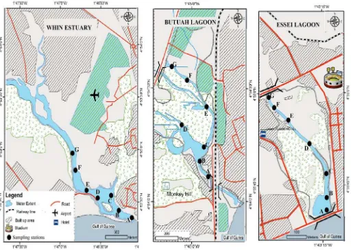
Protection Agency have pledged their support to CRC’s objective of creating Ghana’s first urban nature reserves for the three wetland areas.
The STMA program, combined with the small grants wetlands program, will form the basis for a larger effort to bring wetlands conservation to the forefront through schools and interactions among community voluntary monitoring groups that CRC hopes will be supported by the private sector. A program for participatory monitoring with communities and schools, coached by UCC and funded by the private sector, is set to evolve into a friendly competition with wetlands scorecards whereby
participants will be rated on conservation, restoration, and threat abatement
indicators. The competition seeks to create better awareness, and notably pride, for the conservation of the wetland areas.
2.1.2 Activity 1.2 Assessment of Legal/Institutional Options for a Nested Coastal Governance System
The present local governance/decentralization system has been evolving since 1988. This activity is intended to review how expectations and objectives (of the decentralization
process) have changed over time. The expected outcome includes the identification of options to be pursued to strengthen and clarify authority and responsibility for land use and fisheries management at the community, district and region scales.
A draft Terms of Reference for this assessment has been designed to clarify the sources and scope of district level authority over land use, shoreline development, and fisheries
management. The task has been provisionally put on hold to allow for the review of an earlier study on the ‘Status of Decentralization in Ghana’ conducted by Development Partners (DP) and the Government of Ghana (GOG). Also, LOGODEP indicated its interest in the study and will collaborate and advise on the possible next steps in the coming semester.
2.1.3 Activity 1.3 Fisheries Working Group for the Western Region
Constraints to effective fisheries management identified in the Phase I included:
• low level of communications between community level efforts in fisheries, the district assemblies and the fisheries authorities and
13
To address the observed constraints, the Hİn Mpoano Initiative sought and received the approval of the Fisheries Commission to constitute and pilot a Fisheries Working Group
(FWG) – a committee of fisheries stakeholders from the Western Region - to work with the Directorate of Fisheries in addressing some of the observed concerns. The FWG is comprised of 11 persons drawn from 9 institutions and representing: Canoe Fishermen, Fishmongers, Industrial and Semi-industrial fleet, Navy, Police, EPA and Attorney General’s Department.
Lessons Learned and Opportunities
Fisheries Working Group
Deliberations of the Fisheries Working Group brought out deep-seated issues and sometimes the subtle, and not so subtle, conflicts and tensions existing between the various fishing groups – issues which often would ordinarily
degenerate into heated arguments and blame passing. The platform provided by the Initiative has offered an opportunity for open and frank discussions and brought together an otherwise disjointed power players and efforts at managing the fisheries sector.
Also, the intricate nature and complexities within the sector has become apparent as the cross-sectoral inputs allowed representatives to understand largely the mandates and the workings of the various sectors and therefore the imperative for one organization or the other to be represented on the Working Group. For example, the Working Group had a rare opportunity to address the
petition of the Sekondi Canoe Owners Associationon the new Fisheries
Regulations (LI 1968) whereby the Association sought to provisionally reverse the ban on light fishing and threatened prolonged non-compliance. This issue was brought to the Working Group and the Attorney General’s Department representative led in the resolution of this misunderstanding as well as other issues in the petition. The Working Group is quickly evolving as the “defacto” forum for discussing and addressing fisheries related issues in the Western Region.
Opportunities: Representatives of the fleets raised some doubts about the official statistics reported on fish landings and associated information. To this end, the inshore semi-industrial fleet has welcomed the Initiative and the Fisheries Commission to develop and pilot a data collection system at the Sekondi Fishing Harbor. As the Initiative is already working with the Commission to improve on catch data and information, the National Service Volunteers and agents of the Commission will be assigned to work with the semi industrial and industrial fleets in the Region on data collection. The semi-industrial fishers have also invited the Initiative to extend its education and other activities to their members as they together with the artisanal fishers share the same marine space and are confronted with similar issues.
14
The group held three meetings to consider pressing issues in the sector to identify channels and mechanisms for communicating the issues to various stakeholders. Also considered were constraints to compliance and enforcement of the new fisheries regulation (LI 1968) passed in August 2010 to give effect to the Fisheries Act 625 of 2002. The group is expected to be inaugurated in the next quarter by the Minister in charge of Fisheries to formalize its activities.
2.2 Component 2: Improved Governance of the Landscape
Introduction
This component seeks develop the enabling conditions and test actions that will coherently address the critical landscape issues identified in Phase I. These issues include: high population pressures; accelerated and unplanned development resulting in the loss of agricultural areas for local food production and hence food and livelihoods insecurity; maintenance of ecosystem services and function; weak governance of the landscape; and vulnerability to climate change.
At the outset, the main challenge is developing capacity for district level planners and local traditional authorities for landscape planning and adherence to negotiate planning that best provides for the food and livelihoods security of communities while maintaining vital ecosystem services and biodiversity. Other important challenges include slowing the pace population growth while identifying promising diversified livelihood activities that fisher folk can practice as fish harvests continue dwindle. Though only a portion of funds for the ICFG Initiative come from the Feed the Future (food security) funding, the piloting of fisheries into food security programs is essential for countries like Ghana where both livelihoods and food security as well the overall economies of the coastal zones and the nation, are heavily dependent a healthy fisheries sector.
The component addresses development-related issues and promotes the conservation of biodiversity and actions designed to sustain the flow of ecological goods and services. It also seeks to improve the social conditions of the coastal population and identifies activities for diversifying livelihoods. Long-term success will depend on changing behaviors and effective co-management of the landscape where communities and districts play a more significant role in steering the development process with the support of the traditional leadership.
The component features three sub-activities:
• Building capacity and commitment for fresh approaches to coastal landscape issues at three focal sites (the Shama District, the Greater Cape Three Points Land and
Seascape; and the Greater Amansuri Wetlands and Coastline).
• Strengthening the capacity of district planners and their respective Assemblies to address land use issues and steer the development process towards desired outcomes • Engagement in cross-district coordination and learning.
15
The three focal areas selected for detailed landscape planning and management are the Greater Amanzuri Wetlands, (Jomoro and Elembelle Districts), the Cape Three Points Land and Seascape (Ahanta West District) and the Shama District. During this semester activities have focused principally on the Shama and Cape Three Points focal areas.
2.2.1.1 Shama District Focal Area
During the first year of the Hİn Mpoano Initiative, the District Chief Executive of Shama requested for assistance in strengthening the District’s spatial and land use planning efforts as Shama District was experiencing accelerated and uncontrollable development driven by evolving extractive industries and spill over expansion of the STMA. Also, the gas powered electricity generation station begun massive expansion which is encroaching on wetlands in the District. The compulsory acquisition of land for planned projects such as free trades zones, new airport and harbor facilities are also creating problems for land use planning.
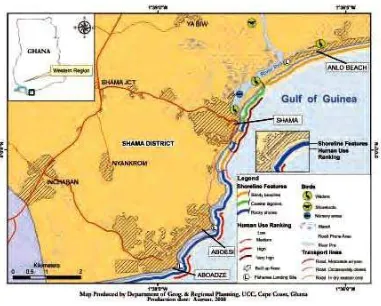
Figure 9:Map of Shama showing the Pra river estuary, built-up area and the coastline
16
If proper planning did not happen within the coming year, both food and livelihoods security for more than half of the rural tenant farmer population would be at risk. Finally, and of equal importance, Shama experiences the effects and social impacts of climate change with an eroding seafront that was densely populated (Fig. 9) and major flooding on the Pra river that cost 11 lives in 2010 and forced the resettlement of two communities. As such, urgent spatial planning assistance was factored into the Year II activities.
The Hİn Mpoano Initiative catalyzed a series of consultations which culminated in a pilot spatial planning and participatory land use mapping exercises. A field team of District
Assembly officials, representatives of Shama Traditional Council, locals (men, women, youth and farmers), faculty of the Department of Geography and Regional Planning (University of Cape Coast) and staff of the Hİn Mpoano Initiative was constituted. The processes explored spatial/land use information in 4 thematic areas: past, present, land-based livelihoods and future/preferred land uses.
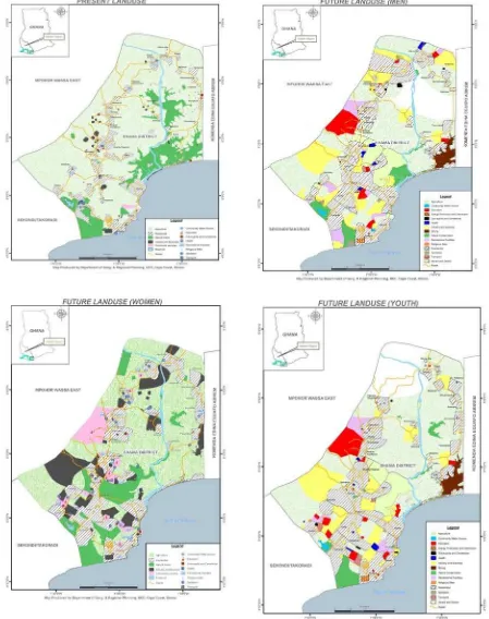
The exercise resulted in the delineation of the district landscape into 4 traditional boundaries that were defined through sub-chieftaincies and other social criteria (Fig.10) that coincided with the areas of jurisdiction of the chiefs. A series of maps were generated through the exercise (Fig. 11) which addressed the aspiration of stakeholders; categorized into present, future land uses (men, women and youth).
17
The priority/critical issues identified for follow up studies are described below:
Flooding
Although Shama is a relatively low lying coastal district it is strongly affected by the high amount of rainfall in the Western Region, as well as its intensity. Major floods have caused widespread damage and loss of life in the watershed and downstream flood plains of the Anankwari River. In recent years, the banks and floodplain of the Pra River have been experiencing severe flooding due to intense periods of rain, prompting the need to resettle some villages. The mouth of the Pra River consists of a barrier spit and dynamic near shore environment that is generally accumulating beach area due to the fact that the Pra is a major source of sand to the beaches of the region. However, other parts of the shoreline along the length of Shama town are experiencing high rates of erosion prompting the installation of hardened shoreline, mainly riprap.
Inadequate means to resettle
The District encounters resistance from some community members on whether to leave flood prone areas and demands for nearly full financial and material support to implement
relocation agreements. As additional flood prone areas are discovered, relocation sites and support to families will be required.
Competing land uses
Land uses, usually are kept separated, are found overlapping and crowding out each other. In some cases, when a more financially rewarding use becomes a possibility, tenant farmers are forcibly relocated. Industrial, commercial, and tourism uses are increasing, notably with quarries, sand and gravel extraction and other forms of mining that are of serious concern for the District.
Prime areas used for food production (as contrasted to cash crops such as palm oil, forest products) are being converted to industrial, business and residential uses without reference to any land development objectives or spatial planning scheme.
Lack of access to potable sources of water
The major water treatment and distribution facility and reservoir for Shama and the STMA is located in Shama District. It combines water taken upstream from the Pra River as well as the rain-fed surface water reservoir. The quantity of water is also affected by upstream water withdrawals piped to the Central Region. The quality is affected by periodic salt water
intrusion, high sediment loads due to land use and mining operations. Shama has a low rate of household coverage for potable water, and the system is generally unable to meet the
continually growing demand for water. Finally, flooding periodically impacts the reservoir overspilling the dam, in part due to siltation and non-functioning dam water release
18
19
Success Story
Empowering Local Leaders and Communities to Make Decisions
Two rather unexpected and quick successes came from the Shama exercise.
Unexpected, because this behavior change happened so quickly dramatically. In land use/spatial planning decision-making at the district level, the roles of chiefs, land owning families, clans and peasant farmers living off land had, traditionally, been largely ignored. They were only engaged in post-planning information transfer resulting in alienation and apathetic behavior towards land use planning process. In this exercise, the stakeholders were pleased to be recognized and their participation in the process gave them a sense of ownership and not just passive recipients of a plan generated by government officials, as is often the case. The exercise has generated enthusiasm among stakeholder groups and their assembly representatives in completing the process of shaping the future of what the Shama District should look like. The exercise also revealed to the traditional authorities and community leaders, the resources and potentials available within their territories as well as the critical decisions that would need to be made to protect lives and livelihoods. The initial issues profiling has also generated interest in other planning programs that are now poised to assist the Shama District in addressing certain competing land-use issues through spatial planning.
One example of this is that of the Anlo Beach community (See Fig. 7). Anlo Beach is a fishing community in the Shama District on the eastern side of the estuary of the river Pra (the second largest river in Ghana after the Volta). The settlement has over 300 permanent dwelling situated on a dune with rapidly eroding shoreline. The community is faced with a two pronged threats - annual flooding of the river and sea level rise due to the evolving impacts of climate change. Past attempts at resettling this community to a new area were met resistance. After involving community members in mapping the spatial features and ‘‘visioning’’ for future land uses, the leadership of Anlo Beachbecame aware of the imperative to relocate.
20
Climate Change Vulnerability Assessment
Through this spatial planning exercise, three sites have been identified for piloting best practices in climate change vulnerability assessments and adaptation planning as well as modeling behavior for the practice of integrated coastal management. They are: 1) the
Inchaban reservoir and its floodplain; 2) the Pra river delta and estuary and; 3) the coastline of the Shama District and its adjoining wetlands. The Hİn Mpoano Initiative is presently
engaging other actors such as LOGODEP, the Jubilee Partners Oil and Gas Consortium, and leveraging other support for the District itself in addressing the other critical issues mentioned above in order to complete the District-wide spatial management plan as a collaborative effort.
2.2.1.2 The Greater Cape Three Point Focal Area
21
Figure 12: Map of Cape Three Points Forest Reserve and fringe communities
CRC-Ghana through the Forestry Commission initiated a process of working towards the conservation of the Reserve. In February 2011, the Hİn Mpoano Initiative supported a 2-day retreat at Akwidaa (a fringe community to the reserve) to discuss the status and conservation of the Forest Reserve. The gathering brought together stakeholders from the private sector, development partners, fringe community members, forest guards, Community Based Advisory Groups (CBAG), traditional authorities and the Ahanta West District Assembly.
The outcome of the retreat was the formation of an 8-member working group to develop a conservation and management action plan for 2011 and a 5-year management plan for the reserve. The working group has representatives from the private sector, NGOs, local elders, and government. It held its maiden meeting in March to review previous management plans and other literature on the reserve.
22
in pooling corporate social responsibility funds for biodiversity conservation actions and has provisionally selected the Cape Three Points Forest Reserve as a site for long-term investment in Ghana.
In the periphery of the forest reserve several actions have been initiated through the small grants program and partnerships for wetlands conservation. These include wetlands conservation programs at Butre and Akwadaa as well as educational programs and tourism guide training at these sites as well as Busua and Princestown. Progress on the marine protected area aspect of this focal area is described under Activity 3.4 of this progress report.
2.2.1.3 Greater Amansuri Wetlands Focal Area
For the Greater Amansuri Wetlands Focal Area (Fig. 13), progress to date has mainly consisted of the development of partnerships and preparation of future surveys. A Memorandum of Understanding (MOU) has been signed with Forest Trends (a US based NGO specializing in identifying markets for ecosystem services for either REDD funding, voluntary carbon offsets, or biodiversity offsets). Forest Trends is developing a program aimed at assisting the Initiative to study carbon sequestration and stocking of the diverse wetlands habitats in the Greater Amansuri Area as well as the opportunities for long-term funding for the conservation of these habitats through evolving mechanisms for paying for ecosystem services. “Blue carbon”, or wetlands and marine, sinks are increasingly showing high carbon sequestration rates and storage and, as such, are increasingly gaining prominence for ecosystem service payment schemes. A series of studies will be developed and
implemented in the coming quarter.
23
Figure 13: Map of the Amanzure Lagoon and associated wetlands in the
Jomoro and Ellembelle Districts
2.2.2 Activity 2.2 Land Use Management at the District Scale
While focusing efforts on the three focal areas, it is essential to also involve the District Chief Executives and District planners in the activities and ensure that they are seen as examples of an approach to land use management that should be applied throughout each coastal district. Thus, the Hİn Mpoano Initiative is investing in a Geographic Information System (GIS) based at University of Cape Coast (UCC) to provide the coastal districts with the fundamental mapping and data processing tools needed for such planning. The districts will be provided with training in GIS and map production as well as providing the District planners with computers, appropriate software and internet access and basic equipment.
The knowledge and tools will equip the districts in generating resource maps for planning and other purposes. Also a pilot web-based knowledge management system that provides access to the information gathered will be developed together with other partners. This will be
supplemented by training workshops associated with the semi-annual M&E events
24
will inform the training schedules of the other planners who will also be involved in the Cape Three Points and Amansuri exercises.
In March 2011, CRC assisted the LOGODEP to develop and hold a workshop on District level spatial planning that brought together representatives from the Shama District as well as four other Districts in the Western Region. In attendance were the other institutions that will also be supporting spatial planning such as the Town & Country Planning Department, the Jubilee Oil and Gas Partners, and the Norwegian government (NORAD) support program for the Ministry of Environment Science and Technology (MEST) for the regional planning framework. A special sub-group was established for ensuring collaboration on spatial planning for the six coastal districts. Unfortunately, the Jubilee Partners program, run by Tullow Oil and the Korean government support to the Ahanta West District, appears to want to develop spatial planning on their own with very little consultative process.
2.2.3 Activity 2.3 Enhancing Livelihoods and Social Conditions
Several activities were identified as those that could contribute to diversifying livelihoods, improving social conditions and quality of life, and making families and communities more resilient to ecosystem change. Targeted activities were tested for viability and where
appropriate, scaled-up for improved food security and poverty reduction. These activities were funded through small grants to local NGOs or associations with technical support from the Initiative.
This report focuses on progress and achievement of three activities: • Small Grants
• Population Health and Environment (PHE)
• Livelihood opportunities /Partnership with Babson College
2.2.3.1 Small Grants
The Small Grants Program was rolled out in August 2010 and extended into Phase II. Major activities of the grant program centered on monitoring the supported projects to ensure they were executed as planned. Thirteen out of the sixteen supported activities were completed. The projects, grant amount and status of each activity are shown in Table 1.
Three projects on livelihoods succeeded in providing beneficiaries with enhanced livelihood schemes. Under food security activities, 20 households (19 women and 1 man) were trained on improved household poultry management and were also supplied with a total of 200 chicks (10 each) to help them increase their income and also improve their family’s nutritional status. Furthermore, 30 other women were supported through the rehabilitation of their working sheds to enable them smoke and sell fish throughout the year. Also, skills training in batik tie and dye benefitted 20 young mothers who are expected to engage in small scale business activities batik tie and dye and soap making.
25
has been established to implement a community by-law for the protection of the mangrove forest. Under ecotourism, 140 tour guides in the west coast tourism destination area were trained.
Table 1: Summary of small grant recipients, activities and grant amount
ORGANIZATION PROJECT TYPE AMOUNT
GHC
BENEFICIARIES AND TARGET
SNV-Western Region Portfolio
Seminars for four west coast Destination Management Area (DMA) and district assemblies on tourism development in the DMA
Eco-tourism 4,185.00 75 trained in tourism,
4 tourism plans developed for 4 districts
SNV-Western Region Portfolio
Training program for tour guides in the west coast DMA
Eco-tourism 6,662.50 65 tour guides trained
SNV-Western Region Portfolio
Marketing of tourism products in five coastal communities of the Ghana west coast DMA
Eco-tourism 9,970.00 Tourism products promoted and marketed
in 5 coastal districts
Ghana Instinct Cycling in paradise eco-biking Eco-tourism 7,890.00 20 people trained in eco-biking
10 bikes and helmets to be acquired
Crisis Action Solutions Towards Essei Lagoon ecological
restoration and conservation
Wetland conservation
4,260.00 Bakano sanitation improved,
Three school clubs for 300 pupils formed and functioning
300 mangroves planted Mangrove destruction halted
Conservation Foundation Mangrove restoration and
conservation project
Wetland conservation
5,013.60 900 mangroves planted
Community bye laws enacted and enforced
Esemaman Development Association
Towards conservation and preservation of coastal resource
Coastal conservation
3,890.00 2000 hand outs produced to educate
community members,
200 member school clubs formed 2 sign posts mounted in community Rural Environmental Care
Association
Enhancing local participation in wetlands conservation and
management through education and awareness creation
Wetlands conservation
8.300.00 Community educated on importance of
wetland. Ampain community and chief made by-law to ban fishing in mangroves
Nzimitianu Community
3,134.00 1500 mangroves planted
Community members aware of need to protect mangroves
27
Ghana Wildlife Society Domunli conservation and
echo-tourism project
Wetlands
conservation and eco-tourism
7,480.00 Eco-tourism livelihood developed for
community
20 people trained in eco-tourism 500 mangroves planted
Anoomasatu Training in realistic livelihood scheme Diversified
livelihood
7,774.00 20 youth mothers trained in batik, tie and
dye and soap making
Master Care Ministries Rehabilitation of sheds for
fishmongers in Shama
Fisheries livelihood 8,700 30 women provided with 10
rehabilitated sheds Organization For
Livelihood Enhancement Services
Household nutrition through local poultry production systems by women in rural communities
Food
security/livelihood
5,091.00 20 household trained in improved poultry
production and provided with 10 chicks to grow to ensure food security
Foundation Of Action And Development
A survey of the sanitation situation in Ngyeresia
Research on sanitation
2,080.00 Research complete on sanitation in
Ngyeresia Department Of Parks And
Gardens-Sekondi
Developing Private-Public Partnerships for upgrading and restoration of Green Public Areas in Sekondi-Takoradi
Private-public partnership
10,000 5 out of 8 public green areas rehabilitated
Gardens seats provided at public park at Adiembra