Yayasan Bersama Lestarikan Nusantara (“Yayasan Belantara”) is an Indonesian grant-making institution formed in 2014 with the goal of delivering wide-ranging community and conservation results. It takes its name from the Indonesian word ‘Belantara’ which means wilderness or pristine forest.
Belantara primary focus is to allocate grants to support restoration, protection, conservation of endangered species (specifically Sumatran Tiger, Sumatran Elephant, as well as Sumatran and Bornean Orangutan), Institutional development,
and community development and empowerment initiatives in Conservation Area, Production Forest, Protection Forest, and Social Forestry on the ten specified grant
distribution areas across five provinces on the islands of Sumatra and Kalimantan (Indonesian Borneo).
Working with local communities, governments, the private sector and NGOs, Belantara relies on a multi-stakeholder approach to better inform decision-making
when addressing resource management problems. As the Essential Ecosystem Areas (KEE) stretch across the grant distribution areas, a coordinated response between all stakeholders for the effective management and preservation of critical
ecosystems is required.
As an independent foundation, Belantara aims to work with all parties that shares its goals, coordinating and collaborating with partner projects within each of its ten specified grant distribution areas. Belantara aims to ensure that existing initiatives are aligned, minimizing the risk of projects overlapping while maximizing
information and data sharing.
Co-founder Asia Pulp and Paper significantly contributed in getting the Foundation off the ground, providing substantial financing. Additional financial resources are being raised from the public and private sectors, while investment de-risking
COFFEE
HISTORY & FACTS
Coffee has a long history and development in Indonesia. The existence of coffee in Indonesia
began in 1696, when the Dutch Governor of Malabar, India, sent Yemeni/Arabica coffee seedlings
to be planted in the island of Java. At first, the seedlings were planted in Kadawung, Batavia (now
Pondok Kopi, Jakarta), but unfortunately failed due to flooding. Three years later the Dutch brought
back new coffee seedlings from Malabar, and this time coffee successfully grew on plantations in Java Island. Now,
coffee grows well in the plantations in Java Island and has surpassed its place of origin, Yemen (Cecep, 2017).
Presently, coffee in Indonesia has developed exponentially with many varieties and clones and can be planted specifically
on any soil conditions and topography in Indonesia. The government has been putting lots of efforts into making coffee
as one of the primary plantation commodity. To a large extent, the spread of coffee crops in Indonesia averages on
smallholder plantations, in which the ownership itself varies, with the average area of land ownership of 2 ha from
transmigration programs and 0.5 ha from native land ownership in Java Island. Up to 2015, the area of coffee plantations
in Indonesia has reached 1.18 million hectares, in which 2,509 ha are state coffee plantations, and 25,447 ha are private
coffee plantations, with exports reaching 502,021 tons, valued at US $ 1.197,735 billion (Ministry of Agriculture, 2016).
One of the Indonesian government’s commitments, which is supported by several development institutions, donors
and companies is the encouragement of SCOPI (Sustainable Coffee Platform of Indonesia), a non-profit association with
objectives to improve the management of coffee commodities, maintain production quality, obtain better prices and
access to global markets. An industry study for a sustainable coffee program conducted by Techno Serve concludes that
Indonesia is the worlds second largest exporter of Robusta coffee. The study also states that 7% of Indonesia’s coffee
export volume has been certified or verified as sustainable. Although the domestic consumption of coffee is increasing,
the production, in general, is not; one of the reasons is low productivity, especially in traditional coffee plantations.
THE ECONOMICS OF
INDONESIAN COFFEE
PRODUCTION
According to an industry study for a sustainable coffee program released in March 2014, Indonesia’s coffee production is supplied by 1.5 million smallholder groups with an average land holding of less than 1 ha per smallholder. Even so, it is estimated that only half a million of these coffee smallholders actively work on their plantations for commercial purposes. More than 60% of robusta coffee produced in Indonesia is based in South Sumatra Province.
Indonesia’s coffee market is very free; local and international exporters can compete. Most coffee smallholders are not organized, and the role of the cooperatives is very weak, and is exploited by middlemen and collectors who sell green coffee beans to exporters. Exporters control the added value of processing and export standards preparation.
The low productivity of coffee-producing land per ha in Indonesia is an important issue for future improvement. Vietnam, with an area of 1 ha per farmer/household, is able to produce 3 times more than active coffee farmers in Indonesia and has successfully increased their coffee production significantly over the past 30 years, while Indonesia’s coffee production has been experiencing a stagnating trend. A trend that is influenced by the aging coffee plants and the lack of smallholders who adopt Good Agricultural Practices (GAP) such as pruning and integrated pest control.
COFFEE
CLIMATE AND
TYPES
1. COFFEA ARABICA
Climate: Arabica coffee (Coffea arabica) is ideally grown with the altitude between 1000-2000 m asl and a required rainfall of 1250-1000-2000 mm per year. Arabica coffee was the first coffee brought by the Dutch to Indonesia and planted on the island of Java. Arabica coffee was once a major coffee export commodity to the European countries.
Physical characteristics:
Arabica coffees can be physically identified from the form of its plants and its small-sized fruit. Arabica coffees are low in caffeine, and poses a fragrant aroma compared to the other two types of coffee. The leaves are smooth, and the wave and bone of the leaves are not clearly visible. Arabica coffees are mostly located on plateaus. Famous Arabica coffee producers in Indonesia are Aceh Province, Pagar Alam (in South Sumatra Province), throughout Java Island (Pangalengan Sub-district, Bogor Regency, Wonosobo Regency, through East Java Province).
2. COFFEA LIBERICA
Climate: The Liberica coffee (Coffea liberica) was planted in Indonesia after the attack of Hemileia vastatrix disease that destroyed the arabica coffee plantations in Java Island. Libericas can be grown in the lowlands between 10 - 900 m asl, especially on acidic-textured peatlands.
Physical Characteristics:
Liberica coffees can be identified by its large fruits and small seeds. The plant’s physiology is almost similar to the jackfruit tree; therefore in some areas, they are also called as the jackfruit coffee.
Benefits: Liberica coffee is known to increase vitality, and prevent degenerative diseases.
2. COFFEA ROBUSTA
Climate: Robusta coffee (Coffea canephora) is the most type of coffee sold in the local market. It is the mainstay for the small cafes to serve affordable coffee to the masses. Robusta has many types of clones and varieties and grows well at an altitude between 100-800 m asl. Robustas requires 1-3 months of dry season or < 60 mm rainfall intensity to stimulate flowering and ensure the flowers do not fall out from the branches before becoming a proper and healthy coffee.
Physical Characteristics:
Robusta coffee can be identified by its flexible stem that extends downwards, large wavy leaves, leaf veins/bone that are clearly visible. Robustas have several variants of clones that are resistant to PBKo and nematodes (Choke Stalk Chocolate). Even so, some do not possess the same resistance to PBKo and nematodes. Robusta coffee are used as a substitute for arabica coffee in the lowlands due to its more resistance to Hemileia vastatrix disease or rust leaf.
Benefits: Robusta coffee is known to be able to neutralize poison of the bongkrek tempeh (a variety of tempeh from Central Jawa) and revive and increase stamina and concentration.
Source: Central Bureau of Statistics, South Sumatra
province in figures (2007-2017)
GEOGRAPHIC AND CLIMATE
INFORMATION OF SOUTH
SUMATRA PROVINCE
There are three Belantara Grant Distribution Areas/Ecosystems in South Sumatra Province. The three ecosystems are (a) The Padang Sugihan Ecosystem, (b) The Dangku Meranti Ecosystem, (c) The Berbak Sembilang Ecosystem.
THE LAND CONDITION OF SOUTH SUMATRA PROVINCE
a. Soil State
South Sumatra consists of eleven types of soils, namely: 1. Organosol : Along the coasts and bogs
2. Lithosol : Along the edges of Lake Ranau’s rugged mountains region along Bukit Barisan’s fault
3. Alluvial : Along the Musi River, the Lematang River, the Ogan River, the Komering River, and the ridges of Bukit Barisan
4. Hydromorphic : In the marshes of Musi Rawas and Muara Enim 5. Gley Humus : Along the coast and in the swamps
6. Regosol : Around the east coast, along the edges and in the volcano cone of Lake Ranau’s rugged mountains region
7. Andosol : In all of the new and old volcanic cones; commonly found 100 meters above sea level
8. Redzina : Baturaja and its surroundings 9. Latosol : Commonly found in the drylands 10. Lateritic : In Martapura’s lowland
b. Climate
200 2004 2005 2006 2007 2008 2009 2010 2011 2012 2013 2014 2015 2016
Rainyday 1614
137 170 198 205 180 210 224 210 274
January February March April May June
There are two Belantara Grant Distribution Areas/Ecosystems in Jambi Province. The two ecosystems are (a) The Bukit Tiga Puluh Ecosystem, (b) The Berbak Sembilang Ecosystem.
THE LAND CONDITION OF JAMBI PROVINCE
a. Soil State
There are three land conditions in Jambi Province based on elevation: Lowlands, Midlands and Highlands.
Topography/Height (m/above sea level)
Area Total Area (ha)
Ha % Area/Regency
Lowlands (0-100) 3,431,165 67 Jambi city, West Tanjung Jabung Regency, East Tanjung Jabung Regency, Muaro Jambi Regency, Merangin Regency, Batang Hari Regency.
Midlands (100-500) 903,180 17 Parts of Sarolangun Regency, Tebo Regency, Parts of Batang Hari Regency, Sungai Penuh City Regency, Merangin Regency, Parts of West Tanjung Jabung Regency.
Highlands (>500) 765,655 16 Kerinci Regency, Sungai Penuh City, Parts of Merangin Regency, Parts of Sarolangun Regency, and parts of Bungo Regency.
Total 5,100,000 100
Source: Jambi Province’s Central Bureau of Statistics, Jambi Province cit RPJMP 2011-2015
a. Lowland : Dominant by lands full of water, susceptible to flood tides, many large and small rivers flow through this area, its soil is dominated by low fertility gley, and its peat areas are dominated by organosol.
b. Midland : Dominant with red-yellow podzolic soil, low fertility.
c. Highland : Dry highland that is dominant with plateus on the western part. Fertile alluvial soil could be found in the central parts of Kerinci Regency.
Source: Central Bureau of Statistics, Jambi (2004-2017) and
Jambi’s RPJMP (2011-2015)
a. 1. The Types of Soil and it’s Percentage
No.
Soil Type
Area (Ha)
%
1
Red-yellow Podzolic
2,036,386
39.93
2
Latosol
952,386
18.6
3
Low Gley Humus
547,830
10.74
4
Andosol
354,406
6.95
5
Organosol
308,338
6.05
6
Brown Podzolic +Andosol+Podzolic
275,652
5.40
7
Red-yellow Podzolic
236,343
4.63
8
Alluvial
199,553
3.91
9
Grey Hydomorphic
83,743
1.64
10
Latosol Andosol
60,032
1.18
11
Sea Swamp
42,951
0.84
12
Latosol + Litosol complex
2,380
0.05
Total
5,100,000
100.00
2007 2008 2009 2010 2011 2012 2013 2014 2015 2016
200 192 206 253 209 191 220 199 179 224
2500 3000 3500
rainfall rainy day
January February March April May June
July August September October November December 0
2007 2008 2009 2010 2011 2012 2013 2014 2015 2016
Source: Central Bureau of Statistics, Riau Province (2009-2016)
GEOGRAPHIC AND CLIMATE
INFORMATION OF RIAU
PROVINCE
In Riau Province, there are five Belantara Grant Distribution Areas/Ecosystem. The five areas are: a. Bukit Tiga Puluh Ecosystem; b. Kerumutan Ecosystem; c. Kampar Peninsula Ecosystem, d. Giam Siak Kecil Bukit Batu Ecosystem, e. Senepis Ecosystem
THE LAND CONDITION OF RIAU PROVINCE
a. Soil State
Based on elevation there are two land conditions in Riau Province: Lowlands and Highlands.
a. 1. Lowlands
No. Soil Type Area Rock Form Physiography
1 Organosol and Gley Humus 5,065,600 Alluvial Flatland
2 Grey Hydromop - Alluvial Flatland
3 Redy-Yellow Podzolic 2,156,000 Alluvial Flatland
4 Red-Yellow Podzolic 68,000 Alluvial Flatland
b. 2. Highlands
No. Soil Type Area Rock Form Physiography
1 Podzol 209,600 Sedimentary rock Flatland
2 Red-Yellow Podzolic - Sedimentary Rocks dan Igneous Rocks
Foldland
3 Red-Yellow Podzolic (Complex) 218,200 Igneous Rocks Intrusion
4 Red-Yellow Podzolic Latosol and Litosol 94,800 Igneous Sedimentary Rocks and Metamorphic Rocks
Mountain area
Source: Central Bureau of Statistics, Riau Province (2009-2016)
GEOGRAPHIC AND CLIMATE
INFORMATION OF RIAU
PROVINCE
In Riau Province, there are five Belantara Grant Distribution Areas/Ecosystem. The five areas are: a. Bukit Tiga Puluh Ecosystem; b. Kerumutan Ecosystem; c. Kampar Peninsula Ecosystem, d. Giam Siak Kecil Bukit Batu Ecosystem, e. Senepis Ecosystem
THE LAND CONDITION OF RIAU PROVINCE
a. Soil State
Based on elevation there are two land conditions in Riau Province: Lowlands and Highlands.
a. 1. Lowlands
No. Soil Type Area Rock Form Physiography
1 Organosol and Gley Humus 5,065,600 Alluvial Flatland
2 Grey Hydromop - Alluvial Flatland
3 Redy-Yellow Podzolic 2,156,000 Alluvial Flatland
4 Red-Yellow Podzolic 68,000 Alluvial Flatland
b. 2. Highlands
No. Soil Type Area Rock Form Physiography
1 Podzol 209,600 Sedimentary rock Flatland
2 Red-Yellow Podzolic - Sedimentary Rocks dan Igneous Rocks
Foldland
3 Red-Yellow Podzolic (Complex) 218,200 Igneous Rocks Intrusion
4 Red-Yellow Podzolic Latosol and Litosol 94,800 Igneous Sedimentary Rocks and Metamorphic Rocks
2008
2009
2010
2011
2012
2013
2014
2015
2008 2009 2010 2011 2012 2013 2014
January February March April May June
July August September October November December
In West Kalimantan Province, there is one Belantara’s Grant Area/Ecosystem, which is the Kubu Raya Ecosystem.
Land Condition of West Kalimantan Province
a. Soil State
Based on its soil texture most of West Kalimantan Province consist of red-yellow podzolic soil (RYP), which spread over 10,5 million hectares or 71.28% of West Kalimantan Province. Furthermore, its soil also consists of OGH soil (organosol, gley humus) and alluvial soils, which amounts to 10.29% of West Kalimantan Province or 2 million hectares located in the coastal regencies.
a. 1. The Soil Types per Regency/City in the Ecosystem
No. Regency/City OGH Alluvial Regosol PMK Podzol Latosol
1 Landak Regency 138,152 323 0 761,014 49,621 41,600
2 Pontianak Regency 3,140 56,703 0 36,148 32,329 0
3 Kubu Raya Regency 170,584 462,437 0 33,765 25,468 6,266
4 North Kayong Regency 127,840 197,966 0 57,803 73,217 0
5 Pontianak City 3,600 7,180 0 0 0 0
b. 2. The Soil Textures of the Regencies and City in the Ecosystem
No. Regency/City Smooth Moderate Hard Turf Swamp Others
1 Landak Regency 37,017 707,211 246,682 114,214 0 0
2 Pontianak City 35,282 33,149 20,095 39,164 0 0
3 Kubu Raya Regency 403,139 716 0 292,665 0 0
4 North Kayong Regency 271,005 130,369 0 55,452 0 0
5 Pontianak City 7,860 2,920 0 1,100 0 0
Source: Central Bureau of Statistics, West Kalimantan Province
(2009-2016)
GEOGRAPHIC AND CLIMATE
INFORMATION OF WEST
2008
2009
2010
2011
2012
2013
2014
2015
01000 2000
3131.8
215 190 257 196 218 217 140
n/a
2008
2009
2010
2011
2012
2013
2014
2015
January February March April May June
Land condition of East Kalimantan Province
a. Soil State
East Kalimantan Province is dominated by red-yellow podzolic soil, latosol, and lithosol types of soil, which spread over the central, and northern parts of East Kalimantan. Other soil types are organosol, latosol, and red-yellow podsolic with low fertility.
Source: Central Bureau of Statistics, East Kalimantan
Province (2009-2016)
GEOGRAPHIC AND CLIMATE
INFORMATION OF EAST
KALIMANTAN PROVINCE
2008 2009 2010 2011 2012 2013 2014 2015 2016
2009 2010 2011 2012 2013 2014 2015 2016
January February March April May June
July August September October November December
10 Ecosystems will be given (3) three classifications of suitability, which are: Very Suitable, indicating that the Ecosystem is very suitable to develop coffee plantations; Suitable, indicates that the Ecosystem is suitable, but requires treatment to yield good produce; Not Suitable, this Ecosystem requires immense effort to plant coffee.
ECOSYSTEMS
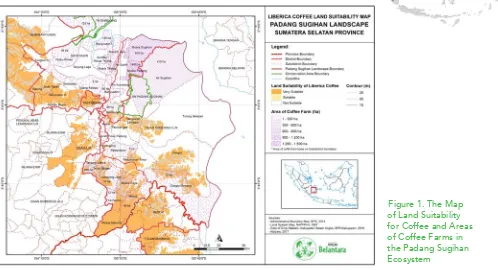
1. The Padang Sugihan Ecosystem (Suitable for Coffee Plantations)
Figure 1. The Map of Land Suitability for Coffee and Areas of Coffee Farms in the Padang Sugihan Ecosystem
Map Analysis: Refer to Figure 1. The Map of Land Suitability for Coffee and Areas of Coffee Farms in the Padang Sugihan Ecosystem.
Based on the land conditions of the Padang Sugihan Ecosystem, the areas outside of the wildlife reserves in this ecosystem are suitable for Robusta coffee plantations, such as the three sub-districts of Ogan Komering Ilir Regency: Cengal Sub-district, Padamaran Timur Sub-Sub-district, and Lampam Sub-district. Additionally, Air Sugihan Sub-district in Ogan Komering Ilir Regency and Muara Padang Sub-district in Banyuasin (outside of the Padang Sugihan Ecosystem) are suitable for Liberica coffee plantations.
Besides rubber and palm oil, coffee plants grown by the rural communities have become one of their primary source of income. Even so, there are improvements needed for the coffee farmers in Air Sugihan Sub-district and Muara Padang Sub-district in GAP (Good Agricultural Practices) and GMP (Good Manufacturing Practices).
education is less than 1%.
There are about 293,700 of productive aged people who mostly work in the agricultural sector of rice and companion crops (41,16%) and plantations (23,78%). About 6.5% of the population work in the fisheries sector, in coastal villages such as the Cengal Sub-district, Sungai Menang Sub-district, Tulung Selapan Sub-district, Muara Sugihan Sub-district, and the Banyuasin I Sub-district. The rubber commodity remains the mainstay in the plantation sector of the Padang Sugihan Ecosystem, both in the OKI Sub-district and Banyuasin Sub-district. There are also small parts of areas that are planted with palms, coconuts, cacaos, and coffees (Belantara, 2017). Conclusion: The ecosystem of Padang Sugihan is potential for cultivating Liberica and Robusta coffees. Even so, besides GAP (Good Agricultural Practices) improvement, finding a captive market and a lean supply chain to be connected to the farmers is needed to increase their interest in planting coffee as their primary commodity.
The plantation commodities in the Padang Sugihan Ecosystem
Regencies/Cities Cacao Rubber Palm Oil Coconut Coffee Others
Ogan Komering Ilir 396.20 153,237 12,845.00 3,895.00 277.43 4.00
Banyuasin 216.21 71,522.90 26,518.28 24,234.15 470.36 10.10
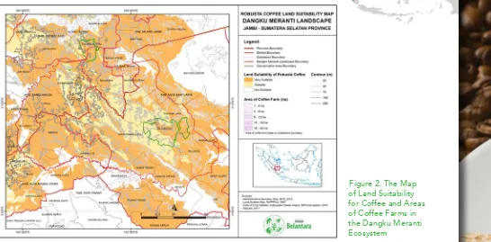
2. Dangku Meranti Ecosystem - (Very Suitable for Coffee Plantations)
Figure 2. The Map of Land Suitability for Coffee and Areas of Coffee Farms in the Dangku Meranti Ecosystem
Map Analysis: Refer to Figure 2. The Map of Land Suitability for Coffee and Areas of Coffee Farms in the Dangku Meranti Ecosystem.
The Dangku Meranti Ecosystem is very suitable for coffee cultivation, both within and outside of the protected areas. However, almost all the farmers in this ecosystem plant rubber, palm oils, or coconut (for copras). This is due to the growth of supporting industries, such as rubber and palm oil mills near the ecosystem of Dangku Meranti.
In this Ecosystem, besides traditional farming, many rubber and palm oil plantations in this area are built by plasma factories. The existence of intermediaries around this region also contributes to the growth of the rubber commodity supply chain.
Regarding education, 21.41% of Dangku Meranti Ecosystem’s populace have not graduated primary school, 32.72% have graduated from primary school, 17.53% have graduated middle school, and 17.20% have graduated high school.
The types of crops cultivated by the smallholder farmers are rubber, palm oil, cacao, coconut, and coffee. There are 520,313.14 hectares of rubber smallholders, and 203,874.90 hectares of palm oil smallholders. Cacao crops are dominant in Muaro Jambi Regency, while coconut crops are dominant in Musi Banyuasin Regency. Coffee is grown in Musi Rawas Regency and covers an area of 2,296.28 hectares (Belantara, 2017).
Conclusion: Although the land conditions of the Dangku Meranti Ecosystem is very suitable for planting coffee, it is not the primary crop grown. The average smallholder in this ecosystem grows rubber crops. Consequently, the Dangku Meranti Ecosystem is the largest rubber commodity supplier in South Sumatra Province.
The plantation commodies in the Dangku Meranti Ecosystem
Regency/city
Smallholder Farmers Plantation Area (hectare)
Gambir
Cacao
Rubber
Palm Oil
Coconut
Coffee
Areca nut
Musi Rawas
-
408.81
170,253.69
26,753.84
206.56
2,296.28
2.66
Musi Banyuasin
108,25
295.59
145,655.74
60,829.44
3,128.60
21.53
4.44
Sarolangun
-
104.60
84,716.85
17,301.61
50.90
15.67
3.07
Batang Hari
-
100.36
68,657.74
35,187.74
143.53
5.48
13.51
Muaro Jambi
-
1,821.72
48,658.52
56,070.80
542.43
6.87
93.41
Kota Jambi
-
95.47
2,370.59
7,731.47
461.69
6.50
79.08
Total
108,25
2,826.55
520,313.14
203,874.90
4,533.70
2,352.33
196.17
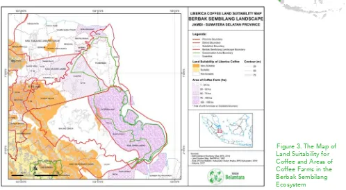
3. Berbak Sembilang Ecosystem – (Not Suitable for a Coffee Plantations)
Figure 3. The Map of Land Suitability for Coffee and Areas of Coffee Farms in the Berbak Sembilang Ecosystem
Map Analysis: Refer to Figure 3. The Map of Land Suitability for Coffee and Areas of Coffee Farms in the Berbak Sembilang Ecosystem.
Coffee is not the primary commodity grown in the ecosystem of Berbak Sembilang, but is planted as a companion crop or a seasonal crop. The location of the plantations in this ecosystem is in the peat areas, which is directly affected by sea water. The population in this ecosystem tend to rely on coastal and sea-based products, such as shrimp paste, shrimp, and shrimp crackers.
The Berbak Ecosystem is surrounded by HTI (Industrial Forest Plantation) concessions, therefore obtaining land for coffee plantations, either for planting coffee from the initial stage as well as seeking farmers who focus on coffee as their primary crop is quite difficult..
middle school, 18.93% graduated high school, less than 5% achieved higher education. Of the 272,208 working aged people, 29.10% works in the plantation sector, 16.88% works cultivating rice and companion crops, 4.10% works in the fisheries sector, 16.25% works in the trade sector, 8.57% works in the public service sector, 5.76 works in construction, 4.08% in transportation and warehousing, 3.67% works in education, and 3.05% works in the processing industry.
The prominent plantations in the Berback Sembilang Ecosystem are coconuts, rubber, and palm oils. Transmigrants, utilizing two hectares of land granted by the government initially planted coconuts; by time, with palm oil and rubber companies coming in, and with the development of their plantations, coconut plants were later replaced by palm oil and rubber (Belantara, 2017).
Conclusion: Coffee in the Berbak Sembilang Ecosystem is only suited to be panted in the peatlands. However, with coastal residents who depend their lives on the coastal and sea, HTIs surrounding the ecosystem, as well as the geographics of the Berbak Sembilang Ecosystem, coffee is not planted widely in this ecosystem and would require considerable effort, and would be less profitable to cultivate.
Plantation commodity in the Berbak Sembilang Ecosystem
Plantation
Crops
Plantation areas by farming household (hectare)
Total area (ha) Muaro Jambi East Tanjung Jabung Jambi City Musi Banyuasin Banyuasin
Rubber 48,658.52 104.24 2,370.59 145,655.74 71,522.90 276,312.00
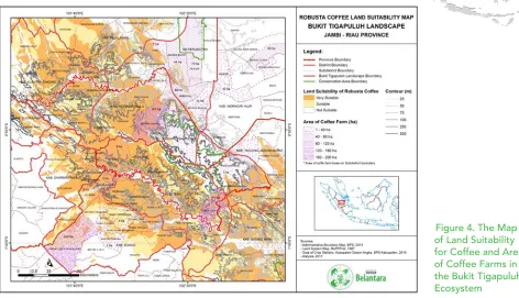
4. Bukit Tigapuluh Ecosystem – (Very Suitable for Coffee Plantations)
Figure 4. The Map of Land Suitability for Coffee and Areas of Coffee Farms in the Bukit Tigapuluh Ecosystem
Map Analysis: Refer to the Figure 4. The Map of Land Suitability for Coffee and Areas of Coffee Farms in the Bukit Tigapuluh Ecosystem.
Rubber, palm oil, and coconut plantations dominate the Bukit Tiga Puluh Ecosystem and are the primary source of income for the farmers in this ecosystem. Besides the primary commodities of rubber, palm oil and coconut, farmers also grow companion crops, such as coffee, cacao, areca nuts, and various types of companion crops. Even so, Tabung Jabung Regency has its own uniqueness, the farmers in this area have arranged a geographically based farmer group that produces a unique blend of coffee, which is called the Kuala Tangkal Liberica Coffee or the Kuala Tangkal Peat Coffee. The coffee farmers in this ecosystem also plant companion trees as shades for the coffee plants and areca palms.
There are about 303,170 of productive aged people. The majority of them work in plantations (62.37% or 189,102 people), which far exceeds other sectors, such as trade (11.31%), community services (6.66%), and education (4.82%). The percentage of those working in agriculture (rice or companion crops) is tiny, 5.22% (15,204). The significant amount of workers in the plantation sector shows that this sector can absorb labor, especially smallholder farmers.
Based on the Agricultural Census of 2013 it is seen that the smallholder farmers in and around the landscape rely on three primary commodities, which are rubber, palm oil and coconut (Belantara, 2017).
Conclusion: The Bukit Tiga Puluh Ecosystem has an excellent liberica coffee product from Tanjung Jabung Regency. However, since most coffee farmers in this ecosystem intercrop coffee and areca nuts together, assistance in GAP (Good Agricultural Practices) is needed. Additionally, assistance for GMP (Good Manufacturing Practices) to ensure that the farmer’s product can compete in the downstream industry is highly recommended.
Plantation Commodities in the Bukit Tigapuluh Ecosystem
Regency/City
Plantation Areas (hectares)
Clove Cacao Rubber Palm Oil Coconut Coffee Pepper Areca nut Sago Others
Kuantan Singingi 7.01 149.26 47,925.25 36,469.14 288 10.15 0.05 8.62 0.13 0
Indragiri Hulu 0.26 533.94 46,810.77 79,434.38 262.05 14.94 0.01 182.84 0 0.5
Indragiri Hilir 5.3 93.1 3,939.32 61,178.64 210,107.10 468.58 0.17 10,055.61 1,108.03 13.89
Tanjung Jabung Barat 0 77.22 9,754.04 54,711.50 35.587.47 3,792.77 3.18 16,712.97 0 0
Tebo 0.77 317.52 109,203,.3 28,019.47 189.31 27.17 0.16 7.16 0 0
Bungo 6.27 214.69 78,753.80 34,655.78 134.2 489.63 0 10.49 0 0
Total areas (Ha) 19.61 1,385.74 296,386.90 294,468.91 246,568.14 4,803.25 3.57 26,977.69 1,108.15 14.39
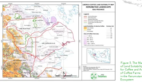
5. Kerumutan Ecosystem – (Suitable for Liberica Coffee Plantations)
Figure 5. The Map of Land Suitability for Coffee and Areas of Coffee Farms in the Kerumutan Ecosystem
Map Analysis: Refer to Figure 5. The Map of Land Suitability for Coffee and Areas of Coffee Farms in the Kerumutan Ecosystem.
Palm oil and coconut plantations encompass the ecosystem of Kerumutan. Riau Province is one of the major palm oil (CPO) and packaged coconut milk producing provinces, with Indragiri Hilir Sub-district being the center of Indonesia’s coconut commodity that is supported by the local government to make coconuts a primary focus for the downstream processing industry. Besides the prolific palm oil and coconut plantations, the coffee commodity in this ecosystem is also quite developed as there are many liberica coffee plantations near Kuala Kampar Sub-district.
The Social-Economic Profile of the Kerumutan Ecosystem: The majority of the population are Muslims, while the ethnicity includes Malay, Javanese, Minang, and some Sulawesi tribes. There are two indigenous minorities in this Ecosystem, namely the Petalangan Tribe and the Duanu Tribe. There are also 29 “Pebatinan” and “Kepenghuluan” in this Ecosystem, which originated from the Pelalawan Kingdom.
companion crops (9.09%). Besides those, the percentage of workers in other sectors is not very prominent, the processing industry (5.55%), construction (3.39%), fishery (2.04%), and forestry (1.04%).
The majority of people aged five years and over have completed primary school (33.91%), although 21.93% have not or did not finish primary school. More than half of the Kerumutan Ecosystem educational level is primary education. Those who have graduated middle school or it’s equivalent is as much as 17.16 %; high school/equivalent graduates are 16.22%.
Based on the dedicated land area and the type of plant, plantation commodities are the mainstay of the population in the Kerumutan Ecosystem, especially palm oils, with a land area of 546,094 hectares, and coconuts with the land area of 461,031 hectares. The most massive coconut plantation is located in Indragiri Hilir Regency, whereas many palm oils are grown in Indragiri Hilir Regency and Pelalawan Regency (Belantara, 2017).
Conclusion: Coffee crops in the Kerumutan Ecosystem is mostly cultivated around Rangsang Island Sub-district, Meranti Island Regency. However, the the liberica coffee in this ecosystem experiences fluctuating production capacity and needs GAP (Good Agricultural Practices) inputs and modifications. Also, there need to be improvements in supply chain and marketing.
Plantation Commodities in the Kerumutan Ecosystem
Regency/City
Plantation areas and type of crops (hectares)
Rubber
Coconut
Palm Oil
Coffee
Areca nut
Indragiri Hulu
61,372
1,828
11,897
348
383
Indragiri Hilir
5,369
442,335
228,052
1,237
16,384
Pelalawan
29,074
16,868
306,145
1,289
53
Total
95,815
461,031
546,094
2,874
16,820
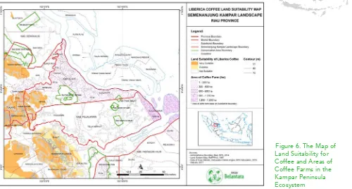
6. Kampar Peninsula Ecosystem – (Not Suitable for Coffee Plantations)
Figure 6. The Map of Land Suitability for Coffee and Areas of Coffee Farms in the Kampar Peninsula Ecosystem
Map Analysis: Refer to Figure 6. The Map of Land Suitability for Coffee and Areas of Coffee Farms in the Kampar Peninsula Ecosystem.
A look at the Land Suitability Map for Coffee in the Kampar Peninsula Ecosystem it is seen that it is mostly white and only a few hotspots for coffee exist. It is because the land is unsuitable for planting coffee. Palm oil and rubber plantations dominate this area as most of the inhabitants depend on palm oil plantations, either by becoming plasma farmers, plantation workers, freelancers, factory workers, or transporters of palm oil yields.
The residents of the Kampar Peninsula Ecosystem receives GAP (Good Agricultural Practices) knowledge from training initiated factories through its CSR (Corporate Social Responsibility) and core programs. Similar to the coffee in Kerumutan’s Ecosystem, the coffee grown in this ecosystem are liberica coffees and are grown around Sungai Apit Sub-district and areas near Kala Kampar Sub-district and Rangsang Sub-district, outside of the ecosystem’s boundaries. The Rangsang Sub-district has had an influence on the distribution of liberica coffee to its surrounding areas.
Buddhists, and Confucians. The majority of people in this Ecosystem aged 15 years old and above have completed primary school (27.44%), although a lot of them have not (21.12%). The percentage of middle school graduates is 21.08%, while high school graduates are 18.06%. Only 6% have a higher education. The number of productive workers in the Kampar Peninsula Ecosystem’s is about 93,472 people. Most of them work in the plantation sub-sector (37.28%), the trade sector (12.28%) and social services (11.33%). There are about 7.8% employed in manufacturing, 5.49% in construction, and 5.31% in the education sector.
Population groups who work in the agricultural sector (rice and companion crops) only amount to 4.13%. The plantation sub-sector is the pillar of most people within the Kampar Peninsula ecosystem. Outside the number of people working in plantation companies, the 2013 Agricultural Census (Central Bureau of Statistics of Riau, 2014) show that at the smallholders level, palm oil has become the most widely planted commodity on their lands. The area of land planted with palm oil reached 171,191.86 hectares, which amounts to five times the area of land planted with rubber, about 34,102.14 hectares (Belantara, 2017).
Conclusion: Coffee is not the primary crop cultivated in the ecosystem of Kampar Peninsula. This ecosystem is enduring a lot of pressure on its protected area and can be a potential for conflict to incur. There are only a few Coffee farmers in this ecosystem, some are farmers from Rangsang Sub-district, an area outside of the Kampar Peninsula Ecosystem boundary. The farmers from Rangsang Sub-district were influential in making liberica coffee as the main coffee variety grown in this ecosystem.
Plantation commodity in the Kampar Peninsula Ecosystem
Regency
Plantation/cultivation Areas (hectares) by small holders
Cacao Rubber Oil palm Coconut Candlenut Coffee Areca nut Sago
Pelalawan
31.68
24,993.90
76,837.62
9,481.36
21.47
60.35
96.12
521.20
Siak
77.04
9,108.24
94,361.24
1,655.95
0.00
12.75
42.45
264.08
Total (Ha)
108.72
34,102.14
171,198.86
11,137.31
21.47
73.09
138.57
785.28
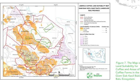
7. Giam Siak Kecil Bukit Batu Ecosystem – (Suitable for Coffee Plantations)
Map Analysis: Refer to Figure 7. The Map of Land Suitability for Coffee and Areas of Coffee Farms in the Giam Siak Kecil Bukit Batu Ecosystem.
The Giam Siak Kecil Bukit Batu (GSKBB) Ecosystem is encompassed by rubber, palm oil, and coconut plantations. Although suitable for coffee, palm oil plantations have been dominating this ecosystem and even tend to monoculture (planted with a single type of plant).
The Social-Economic Profile of the Giam Siak Kecil Bukit Batu Ecosystem: The Giam Siak Kecil-Bukit Batu (GSKBB) Ecosystem is adjacent to the Senepis Ecosystem and Kampar Ecosystem, in fact, there are two regencies/cities in the Senepis Ecosystem that are part of the GSKBB Ecosystem.
work in trade, 12.51% in community service, 7.66% in construction and 7.14% work in the manufacturing industry. People who work in agriculture, livestock, or fishery is only about 1-3% of the total workforce. The 2013 Agriculture Census shows that the largest amount of planted commodities are palm oil, rubber, and coconut; a contrast from areas planted with crops such as rice, companion crops, and horticulture crops. In the same year, the total of rice fields in the GSKBB Ecosystem only amounts to 37,601 hectares of rice fields and agricultural fields. While, the total area planted with maize and cassava is only about 15,611 hectares (Belantara, 2017).
Conclusion: Coffee is not the primary commodity grown in the ecosystem of GSKBB. Communities that grow coffee plants are likely to be migrant/transmigrant communities and are planted to only meet their own needs or as a side commodity that can be sold to collectors or sell in the traditional markets. The commodity development programs in this area should prioritize in the development of the primary commodities to increase its quality and selling value.
Plantation commodities in the GSKBB Ecosystem
Regency/City
Plantation Areas (Ha)
Rubber Coconut Palm Oil Areca Coffee Cacao
Siak 16,129 1,657 287,782 259 140 66
Kampar 101,966 1,806 387,263 99 17 286
Bengkalis 3,786 12,684 198,642 1,005 343
-Rokan Hilir 2,639 5,469 273,145 117 20 260
Pekanbaru 2,926 6 10,745 - - 13
Dumai 2,355 1,929 36,345 103 29 26
Total 129,801 23,551 1,193,922 1,583 549 651
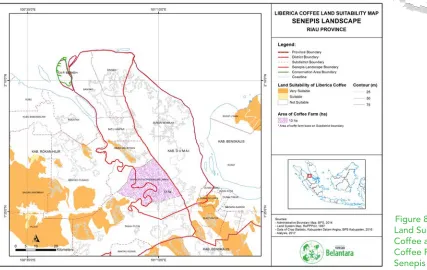
8. Senepis Ecosystem – (Not Suitable for Rubber Plantations)
Map Analysis: Refer to Figure 8. The Map of Land Suitability for Coffee and Areas of Coffee Farms in the Senepis Ecosystem.
Based on the amount of white colored areas that encompassing the Land Suitability for Coffee in the ecosystem of Senepis, it is seen that this ecosystem is unsuitable for coffee plantations. Palm oil is the primary commodity in this ecosystem. Besides palm oil, the community also grows coconut for copras and as the intercrops in their farm. They also plant coarse grains, pulses, and roots and tuber (CGPRT) as intercrops. Several farmers also utilize unused lands for the commodities mentioned above. Coffee plants are only planted as intercrops on a few random spots in this ecosystem.
The Social-Economic Profile of the Senepis Ecosystem: The total population of all the sub-districts in the Senepis Ecosystem is 371,701. The largest population is Dumai Barat Sub-district (89,978 inhabitants), and the least populated area is Batu Hampar Sub-district (7,213 inhabitants).
business sectors.
The majority (106,768) of the population have graduated primary school or its equivalent. People of over 15 years old and working is 126,889. They mostly work in the plantation sector (32.58%), growing rice crops and companion crops (12.91%), trade (12.88%) and community services (13.91%). The percentage of the people working in forestry, fishery, and mining as a whole is around 6.1%.
By comparison, more areas are planted with plantation crops than agricultural crops, such as rice or horticulture. Palm oil is the most popular commodity and has more plantation areas compared to rubber, coconut or cacao in the Senepis Ecosystem (Belantara, 2017).
Conclusion: The ecosystem of Senepis is unsuitable for a Coffee planntation. Moreover, coffeee is not the primary commodity in the Senepis Ecosystem and is only utilized by the community as intercrops amongst coarse grains, pulses, and roots and tuber (CGPRT) crops.
Plantation commodities in Senepis Ecosystem
Type of crops
Plantation areas (ha)
Rokan Hilir Regency Dumai City Total
Farming
Wet rice field 12,271 244 12,515
Dry rice field 14 194 208
Corn 510 41 551
Cassava 316 223 539
Plantation
Rubber 2,926 2355 5,281
Coconut 5,469 1,929 7,398
Palm Oil 273,145 36,345 309,490
Cacao 260 26 286
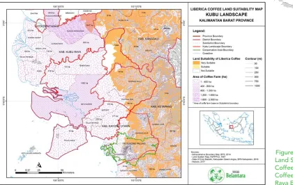
9. Kubu Raya Ecosystem – (Suitable for Coffee Plantations)
Map Analysis: Refer to Figure 9. The Map of Land Suitability for Coffee and Areas of Coffee Farms in the Kubu Raya Ecosystem.
The Kubu Raya Ecosystem has a fairly old history of coffee plantations and is seen by the existence of the early arabica coffee plantings by the Dutch. The communities in the Kubu Raya Ecosystem have made coffee their daily needs, and the many small coffee warungs (traditional stall) that exist in this ecosystem reflects it.
The people in this ecosystem tends to grow coffee as intercrops among their primary crops, which are rubber and palm oil. While in Sanggau Regency coconut is the primary commodity since there is a coconut processing industry in this regency. The quality of coffee produced by smallholders in the ecosystem of Kubu Raya tends to be low, which is caused by the inadequate post-harvesting process. The coffee that they grow on their land is a combination of robustas, libericas, and some arabica derivatives that have potentially mixed with robustas or libericas.
The Social-Economic Profile of the Kubu Raya Ecosystem: The total population in the Kubu Raya Ecosystem is 285,920 people or about 6.5% of the total population of West Kalimantan, which is 4,395,983.
According to the Indonesia Central Bureau of Statistics’s 2014 data of West Kalimantan, about 46.5% of the Kubu Raya Ecosystem’s population work in the plantation sector, a majority compared to other industries. Even so, there are also many of who work in the agricultural sector of rice and companion crops. The percentage of the people who work in construction, transportation, forestry, and mining sectors is below 10%. Besides those, the sectors of finance, transportation, electricity and gas, education services, and social services constitute 8.7% of the population’s work sector.
Based on the educational level, the average people in the Kubu Raya Ecosystem have a basic level of education. In essence, there are those who have or are in the process of completing primary school (32%) and those who have completed primary school (30%). Middle school/equivalent graduates are 11%, while High School/equivalent is about 7%. The percentage of people with higher education (diploma, undergraduate, postgraduate) are still below 2%.
Based on the type of crops grown, rubber and palm oil are the most cultivated commodity by smallholder farmers. Based on the 2013 Agricultural Census of 2013 (West Kalimantan Central Bureau of Statistic, 2014), the amount of land planted with rubber reached 254,096.97 hectares, while the total land areas planted with palm oil reached 101,090.45 hectares. The types of crops grown by the people in Sanggau Regency are mostly palm oil and rubber, while in Kubu and North Kayong, it is rubber, coconut, and coffee. (Belantara, 2017).
Conclusion: The inhabitants of the Kubu Raya Ecosystem have made coffee their daily needs, they are the consumers of coffee products and drive the coffee supply chain demand to run continuously. The community of this ecosystem also tends to grow coffee and other companion crops on their land as intercrops to make up for the fluctuating price of a commodity when it is low.
Plantation commodities in Kubu Raya Ecosystem
Regencies
Plantation areas /cultivation (ha)
Clove Cacao Rubber Palm Oil Coconut Coffee Pepper Areca Sago North Kayong 11.74 4.63 8,218.00 252.21 3,382.50 1,020.94 22.43 6.26 -
Kubu Raya 52.31 62.50 30,392.37 3,999.41 23,209.28 4,053.33 223.10 592.04 296.97
Sanggau 48.65 951.43 121,213.67 67,400.43 670.73 10.42 1,168.20 0.02 1.44
Ketapang 3.50 94.02 94,272.93 29,438.39 1,278.97 372.00 4.79 0.98 0.34
Total (ha) 116.19 1,112.58 254,096.97 101,090.45 28,541.49 5,456.69 1,418.51 599.30 298.75
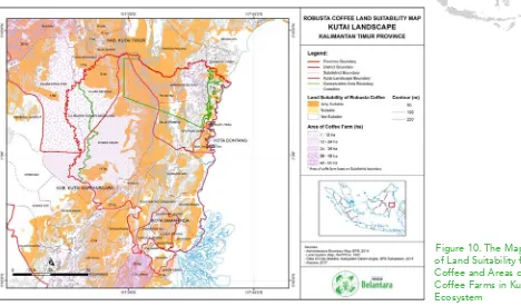
10. Kutai Ecosystem – (Suitable for Coffee Plantations)
Map Analysis: Refer to Figure 10. The Map of Land Suitability for Coffee and Areas of Coffee Farms in the Kutai Ecosystem. Unlike the Kubu Raya Ecosystem, coffee plants in the Kutai Ecosystem have no significant role in the daily life of its inhabitants. Besides of being profoundly impacted by palm oil plantations, coffee plantations in the Kutai Ecosystem, are also affected by horticulture plants and the mining sectors.
Horticulture plants have become the primary commodity in this ecosystem, especially the dragon fruit, which have become an icon on its own. The dragon fruits that are planted along with other crops, such as pepper plants along the main roads reflects this. Usually, the transmigrants are the ones cultivating coffee, as coffee plants need routine maintenance (pruning, fertilization, and harvesting) compared to the simple maintenance of dragon fruits is one of the reasons that coffee is not a primary commodity for the locals.
The Social-Economic Profile of the Kutai Ecosystem: The population of the sub-districts within the Kutai Ecosystem is 1,287,853 people and are predominantly Muslim (91.35%). The highest population density is in Samarinda Seberang Sub-district (9,142 inhabitants/km2), while the lowest population density is in Muara Ancalong Sub-district, which is 4.6 people/km2.
Based on ethnicity, people in the Kutai Ecosystem come from the native ethnicities in the region, i.e., Kutai and some Dayak sub-ethnic groups, such as the Kenyah. However, many residents are also of Bugis and Javanese tribes, which came from transmigration programs since the 1970s.
Based on a person’s last level of education, the percentage of the population aged five years and over who has graduated high school/equivalent is 29.1%, those with only primary school/equivalent education is 22.9%, middle school/equivalent is 18.2%, and those who did or have not finished primary school amounts to 17.8%. While the percentage of people with bachelor degrees or higher is higher than people with I-III diplomas.
There are approximately 561,082 productive-aged people in this Ecosystem. The majority work in trading (17.6%), community services (12.6%), mining and quarrying (10.1%), construction (7.4%), and rice cultivation and companion crops (7.1%). Approximately 8.9% of workers work in the hospitality and restaurants, financial services and insurance, and educational services. In contrast to other Ecosystems, the plantation business in the Kutai landscape is low (3.6%). Based on the 2013 Agricultural Census, the area of plantation cultivated by smallholder farmers in the regencies/cities in the Kutai Ecosystem is not much, including the East Kutai Regency and Kutai Kartanegara Regency where most of the people work in agriculture and plantation sectors. Rubber and palm oils as a whole have the largest planting area in this Ecosystem, rubber reaching 38,942 hectares and palm oil reaching 38,938 hectares. Even so, the total area is far above the areas of land planted with coconut, cacao or pepper (Belantara, 2017).
Conclusion: Although the Kutai ecosystem is suitable for coffee, currently horticultural crops, palm oil, and the mining sector are the main priorities for the locals. Moreover, the characteristics of coffee that need intensive maintenance compared to other horticultural crops have become one of the drawbacks of coffee growth in this ecosystem and one of the reasons that coffee is mainly considered as only a companion crop by the locals and are mostly just planted by transmigrants.
Plantation commodities in Kutai Ecosystem
Regencies/cities
Plantation areas and type of crops managed/cultivated by smallholders
Sugar Palm Clove Cacao Rubber Palm Oil Coconut Candlenut Coffee Pepper Others
Kutai Kartanegara 42 28 1,000 26,167 18,849 2,884 48 172 1,423 6
East Kutai 34 27 2,746 10,472 17,111 1,031 259 172 303 5
Samarinda 22 0 47 1,715 1,833 113 296 46 31 4
Bontang 9 1 53 589 1,145 175 35 27 9 3
TOTAL 107 56 3,845 38,942 38,938 4,202 638 417 1,766 18
COST FOR A COFFEE
PLANTATION PER YEAR
The Cost Estimate of Commodity Development Programs
(Optional)1. Farmer awareness for GAP (Good Agricultural Practices), US $ 120 per person per year
2. Construction of an urban farming demonstration plot for the differentiation of agricultural products, US $ 80 per person per year.
3. Integrated Farming Program (farming and fishery), US $ 650 per person per year. 4. Management program, US $ 1,700 per month.
5. Support program for agricultural and downstream coffee processing machines US $ 7,300 per site (small industries/cooperatives).
REFERENCES
Anonim, 2017. Inilah 10 Negara Tujuan Utama ekspor Kopi Indonesia. https://databoks. katadata.
co.id / datapublish /2017/12/05/inilah-10-negara-tujuan-utama-ekspor-kopi-indonesia.
Accessed 02-01-18 11:22
Belantara, Yayasan.2017.Panduan Yayasan Belantara: Rencana Pengembangan Konservasi di Area Hibah Target di Sumatera dan Kalimantan. Yayasan Belantara. Jakarta Pusat.
BPS.2002-2017. Jambi dalam angka 2002-2017.Badan Pusat Statistik.Jambi
BPS.2002-2017. Sumatra Selatan dalam angka 2002-2017.Badan Pusat Statistik.Sumsel
BPS.2008-2016. Kalimantan Barat dalam angka 2008-2016.Badan Pusat Statistik.Kalbar
BPS.2009-2017.Kalimantan Timur dalam angka 2009-2017.Badan Pusat Statistik.Kaltim
BPS.2008-2015.Riau dalam angka 2008-2015.Badan Pusat Statistik.Riau
Kementrian Pertanian, Dirjen Perkebunan.2016. Buku Statistik Perkebunan Indonesia: Kopi 2015-2017. Kementan. Jakarta
Risnandar, Cecep. 2017.Sejarah Kopi. www.jurnalbumi.com/sejarah-kopi.
Accessed 09-05-17.