Yayasan Bersama Lestarikan Nusantara (“Yayasan Belantara”) is an Indonesian grant-making institution formed in 2014 with the goal of delivering wide-ranging community and conservation results. It takes its name from the Indonesian word ‘Belantara’ which means wilderness or pristine forest.
Belantara primary focus is to allocate grants to support restoration, protection, conservation of endangered species (specifically Sumatran Tiger, Sumatran Elephant, as well as Sumatran and Bornean Orangutan), Institutional development,
and community development and empowerment initiatives in Conservation Area, Production Forest, Protection Forest, and Social Forestry on the ten specified grant
distribution areas across five provinces on the islands of Sumatra and Kalimantan (Indonesian Borneo).
Working with local communities, governments, the private sector and NGOs, Belantara relies on a multi-stakeholder approach to better inform decision-making
when addressing resource management problems. As the Essential Ecosystem Areas (KEE) stretch across the grant distribution areas, a coordinated response between all stakeholders for the effective management and preservation of critical
ecosystems is required.
As an independent foundation, Belantara aims to work with all parties that shares its goals, coordinating and collaborating with partner projects within each of its ten specified grant distribution areas. Belantara aims to ensure that existing initiatives are aligned, minimizing the risk of projects overlapping while maximizing
information and data sharing.
Co-founder Asia Pulp and Paper significantly contributed in getting the Foundation off the ground, providing substantial financing. Additional financial resources are being raised from the public and private sectors, while investment de-risking
PALM OIL
HISTORY & FACTS
Palm oil (Elaeis guineensis) was first brought into Indonesia for the first time by the Dutch
in 1848 to be planted in Bogor’s Botanical Garden (Kebun Raya Bogor); some were
brought into Deli, Aceh (now Deli Serdang, North Sumatra). Palm oil itself originates
from West Africa and is the most potential oil producing vegetable plant, more than
any other plant that can be processed for its vegetable oil. With the mid-19th century
booming industrial revolution came the increasing need of vegetable oil, thus in that
century the Dutch East Indies began massive oil palm plantations, making them the largest exporter of palm
oils in the world.
Palm oil, better known by the name of CPO (Crude Palm Oil), besides being used as a vegetable cooking
oil has a wide-ranging product derivative value, there are more than 150 palm oil derivative products which
use palm oil, such as food coating, healthcare products, dairy products, personal care, biopesticide, and
energy. Due to the multitude of applications that CPO can be used for, and it’s high production capability,
Indonesian CPO repeatedly gains pressure from other vegetable oil producing countries such as sunflower
oil, soybean oil, olive oil, and corn oil producing countries.
THE ECONOMICS OF
INDONESIAN PALM OIL
PRODUCTION
In Indonesia, Palm oil is one of the primary export commodities from the plantation sector. In January-May 2017 non-oil exports reached US $ 61.98 billion, a 20.10% increase from last year’s US $ 51.61 billion with the same period; the contribution of palm oil (CPO) was valued at US $ 9.93 billion or a 16.02% of Indonesia’s non-oil exports (Lutfi, 2017).
Data from the Directorate General of Plantation in 2014 show that palm oil plantations in Indonesia grew to 7.67% between 2004 and 2014, while the production of palm oils increased by an average of 11.09% per year. The increase in palm oil areas is due to the relatively stable price of CPO in the international market and quite a profitable revenue for palm oil producers, especially farmers.
For 2017’s prospect, GAPKI (Indonesian Palm Oil Entrepreneurs Association) provided a reflection in 2016 through its press release on the impact of 2015’s El Nino and how it affected the decline of palm oil production in 2016 that only reached 34.5 million tons (CPO and PKO), down 3% from 2015’s 35.5 million tons (CPO and PKO). Also, in 2017, with the mandatory fuelling policy of biofuels in Indonesia and it’s neighboring country, Malaysia, which is also starting to increase its compulsory fuelling policy of biofuels, palm oil will remain a mainstay. If Indonesia’s and Malaysia’s mandatory biofuels policy run consistently, it will increase the demand for palm oil and cause the global palm oil market supply to decrease, this will, of course, boost the price of palm oil worldwide.
According to plantation statistics issued by Ditjenbun (Directorate General of Estate Crops of Indonesia), palm oil plantations in 2014 owned by smallholder framers reached 4,422,365 ha, government-owned plantations reached 729,022 ha, while the total land area of plantations that are managed by the private sector is 5,603,414 ha. In 2015, the growth of smallholder palm plantations increased by 113,035 ha, totaling 4,535,400 ha, while government-owned plantations only grew 14,872 ha. Private sector plantations grew massively compared to the other two estates, it increased by 377,568 ha, with a total of 5,980,982 ha.
Indonesia’s export destination countries such as India, China, and Pakistan are the primary markets of Indonesian palm oil. Palm oil exports to India during
PALM OIL
CLIMATE AND
TYPES
Palm grows well at an altitude of 1-500 meters above sea level and can optimally produce if planted within the 15th parallel north - 15th parallel south of the equator, with an annual rainfall average of 2000-3500 mm per year and an average humidity of 80- 90%. The temperature required for palm oil plants ranges from 25 ° - 30 ° C, with the best productive temperatures in the range of 25-27 °C. Palm oil plantations in Indonesia stretch from the provinces of Aceh, North Sumatra, Riau, Jambi, Bengkulu, South Sumatra, Lampung, parts of Banten, West Java, All of Borneo, parts of Sulawesi, and now Irian Jaya Island (now called Papua).
The Types of Palm Oils
1. DURA
The Dura palm oil is known for its thick, 2-8 mm palm shells that have almost no fibrous layers –the fibrous layers are very thin, but has thick seeds; consequently, Duras have low oil content. Dura, if mated with pisifera, would be excellent to breed in palm oil breeding programs as it would produce superior saplings. In spite of that , Dura is not recommended for industrial scale planting because the fruit (kernel) will quickly reduce the extraction machines life and will cause the cost of production to be uneconomical.
2. PISIFERA
The Pisifera palm oil is the opposite of the Dura; it has thick fibrous layers, thin seeds, and thin shells (some aren’t shelled). Pisiferas has low oil content. Pisifera is not recommended for commercial planting because only a few have fertilized female flowers, most of which are sterile so they can’t pollinate themselves. Pisiferas are used as a source for male parents and are mated with Duras to produce Tenera tillers.
3. TENERA
Source: Central Bureau of Statistics, South Sumatra
province in figures (2007-2017)
GEOGRAPHIC AND CLIMATE
INFORMATION OF SOUTH
SUMATRA PROVINCE
There are three Belantara Grant Distribution Areas/Ecosystems in South Sumatra Province. The three ecosystems are (a) The Padang Sugihan Ecosystem, (b) The Dangku Meranti Ecosystem, (c) The Berbak Sembilang Ecosystem.
THE LAND CONDITION OF SOUTH SUMATRA PROVINCE
a. Soil State
South Sumatra consists of eleven types of soils, namely: 1. Organosol : Along the coasts and bogs
2. Lithosol : Along the edges of Lake Ranau’s rugged mountains region along Bukit Barisan’s fault
3. Alluvial : Along the Musi River, the Lematang River, the Ogan River, the Komering River, and the ridges of Bukit Barisan
4. Hydromorphic : In the marshes of Musi Rawas and Muara Enim 5. Gley Humus : Along the coast and in the swamps
6. Regosol : Around the east coast, along the edges and in the volcano cone of Lake Ranau’s rugged mountains region
7. Andosol : In all of the new and old volcanic cones; commonly found 100 meters above sea level
8. Redzina : Baturaja and its surroundings 9. Latosol : Commonly found in the drylands 10. Lateritic : In Martapura’s lowland
b. Climate
200 2004 2005 2006 2007 2008 2009 2010 2011 2012 2013 2014 2015 2016 Rainyday
1614
137 170 198 205 180 210 224 210 274
January February March April May June
There are two Belantara Grant Distribution Areas/Ecosystems in Jambi Province. The two ecosystems are (a) The Bukit Tiga Puluh Ecosystem, (b) The Berbak Sembilang Ecosystem.
THE LAND CONDITION OF JAMBI PROVINCE
a. Soil State
There are three land conditions in Jambi Province based on elevation: Lowlands, Midlands and Highlands.
Topography/Height (m/above sea level)
Area Total Area (ha)
Ha % Area/Regency
Lowlands (0-100) 3,431,165 67 Jambi city, West Tanjung Jabung Regency, East Tanjung Jabung Regency, Muaro Jambi Regency, Merangin Regency, Batang Hari Regency.
Midlands (100-500) 903,180 17 Parts of Sarolangun Regency, Tebo Regency, Parts of Batang Hari Regency, Sungai Penuh City Regency, Merangin Regency, Parts of West Tanjung Jabung Regency.
Highlands (>500) 765,655 16 Kerinci Regency, Sungai Penuh City, Parts of Merangin Regency, Parts of Sarolangun Regency, and parts of Bungo Regency.
Total 5,100,000 100
Source: Jambi Province’s Central Bureau of Statistics, Jambi Province cit RPJMP 2011-2015
a. Lowland : Dominant by lands full of water, susceptible to flood tides, many large and small rivers flow through this area, its soil is dominated by low fertility gley, and its peat areas are dominated by organosol.
b. Midland : Dominant with red-yellow podzolic soil, low fertility.
c. Highland : Dry highland that is dominant with plateus on the western part. Fertile alluvial soil
Source: Central Bureau of Statistics, Jambi (2004-2017) and
Jambi’s RPJMP (2011-2015)
a. 1. The Types of Soil and it’s Percentage
No.
Soil Type
Area (Ha)
%
1
Red-yellow Podzolic
2,036,386
39.93
2
Latosol
952,386
18.6
3
Low Gley Humus
547,830
10.74
4
Andosol
354,406
6.95
5
Organosol
308,338
6.05
6
Brown Podzolic +Andosol+Podzolic
275,652
5.40
7
Red-yellow Podzolic
236,343
4.63
8
Alluvial
199,553
3.91
9
Grey Hydomorphic
83,743
1.64
10
Latosol Andosol
60,032
1.18
11
Sea Swamp
42,951
0.84
12
Latosol + Litosol complex
2,380
0.05
Total
5,100,000
100.00
2007 2008 2009 2010 2011 2012 2013 2014 2015 2016
200 192 206 253 209 191 220 199 179 224
2500 3000 3500
rainfall rainy day
January February March April May June
July August September October November December
0
2007 2008 2009 2010 2011 2012 2013 2014 2015 2016
Source: Central Bureau of Statistics, Riau Province (2009-2016)
GEOGRAPHIC AND CLIMATE
INFORMATION OF RIAU
PROVINCE
In Riau Province, there are five Belantara Grant Distribution Areas/Ecosystem. The five areas are: a. Bukit Tiga Puluh Ecosystem; b. Kerumutan Ecosystem; c. Kampar Peninsula Ecosystem, d. Giam Siak Kecil Bukit Batu Ecosystem, e. Senepis Ecosystem
THE LAND CONDITION OF RIAU PROVINCE
a. Soil State
Based on elevation there are two land conditions in Riau Province: Lowlands and Highlands.
a. 1. Lowlands
No. Soil Type Area Rock Form Physiography
1 Organosol and Gley Humus 5,065,600 Alluvial Flatland
2 Grey Hydromop - Alluvial Flatland
3 Redy-Yellow Podzolic 2,156,000 Alluvial Flatland
4 Red-Yellow Podzolic 68,000 Alluvial Flatland
b. 2. Highlands
No. Soil Type Area Rock Form Physiography
1 Podzol 209,600 Sedimentary rock Flatland
2 Red-Yellow Podzolic - Sedimentary Rocks dan
Igneous Rocks
Foldland
3 Red-Yellow Podzolic (Complex) 218,200 Igneous Rocks Intrusion
4 Red-Yellow Podzolic Latosol and Litosol 94,800 Igneous Sedimentary Rocks and Metamorphic Rocks
Mountain area
Source: Central Bureau of Statistics, Riau Province (2009-2016)
GEOGRAPHIC AND CLIMATE
INFORMATION OF RIAU
PROVINCE
In Riau Province, there are five Belantara Grant Distribution Areas/Ecosystem. The five areas are: a. Bukit Tiga Puluh Ecosystem; b. Kerumutan Ecosystem; c. Kampar Peninsula Ecosystem, d. Giam Siak Kecil Bukit Batu Ecosystem, e. Senepis Ecosystem
THE LAND CONDITION OF RIAU PROVINCE
a. Soil State
Based on elevation there are two land conditions in Riau Province: Lowlands and Highlands.
a. 1. Lowlands
No. Soil Type Area Rock Form Physiography
1 Organosol and Gley Humus 5,065,600 Alluvial Flatland
2 Grey Hydromop - Alluvial Flatland
3 Redy-Yellow Podzolic 2,156,000 Alluvial Flatland
4 Red-Yellow Podzolic 68,000 Alluvial Flatland
b. 2. Highlands
No. Soil Type Area Rock Form Physiography
1 Podzol 209,600 Sedimentary rock Flatland
2 Red-Yellow Podzolic - Sedimentary Rocks dan
Igneous Rocks
Foldland
3 Red-Yellow Podzolic (Complex) 218,200 Igneous Rocks Intrusion
4 Red-Yellow Podzolic Latosol and Litosol 94,800 Igneous Sedimentary Rocks and Metamorphic Rocks
2008
2009
2010
2011
2012
2013
2014
2015
2008 2009 2010 2011 2012 2013 2014
January February March April May June
July August September October November December
In West Kalimantan Province, there is one Belantara’s Grant Area/Ecosystem, which is the Kubu Raya Ecosystem.
Land Condition of West Kalimantan Province
a. Soil State
Based on its soil texture most of West Kalimantan Province consist of red-yellow podzolic soil (RYP), which spread over 10,5 million hectares or 71.28% of West Kalimantan Province. Furthermore, its soil also consists of OGH soil (organosol, gley humus) and alluvial soils, which amounts to 10.29% of West Kalimantan Province or 2 million hectares located in the coastal regencies.
a. 1. The Soil Types per Regency/City in the Ecosystem
No. Regency/City OGH Alluvial Regosol PMK Podzol Latosol
1 Landak Regency 138,152 323 0 761,014 49,621 41,600
2 Pontianak Regency 3,140 56,703 0 36,148 32,329 0
3 Kubu Raya Regency 170,584 462,437 0 33,765 25,468 6,266
4 North Kayong Regency 127,840 197,966 0 57,803 73,217 0
5 Pontianak City 3,600 7,180 0 0 0 0
b. 2. The Soil Textures of the Regencies and City in the Ecosystem
No. Regency/City Smooth Moderate Hard Turf Swamp Others
1 Landak Regency 37,017 707,211 246,682 114,214 0 0
2 Pontianak City 35,282 33,149 20,095 39,164 0 0
3 Kubu Raya Regency 403,139 716 0 292,665 0 0
4 North Kayong Regency 271,005 130,369 0 55,452 0 0
5 Pontianak City 7,860 2,920 0 1,100 0 0
Source: Central Bureau of Statistics, West Kalimantan Province
(2009-2016)
GEOGRAPHIC AND CLIMATE
INFORMATION OF WEST
2008
2009
2010
2011
2012
2013
2014
2015
0 1000 2000
3131.8
215 190 257 196 218 217 140
n/a
2008
2009
2010
2011
2012
2013
2014
2015
January February March April May June
July August September October November December
Land condition of East Kalimantan Province
a. Soil State
East Kalimantan Province is dominated by red-yellow podzolic soil, latosol, and lithosol types of soil, which spread over the central, and northern parts of East Kalimantan. Other soil types are organosol, latosol, and red-yellow podsolic with low fertility.
Source: Central Bureau of Statistics, East Kalimantan
Province (2009-2016)
GEOGRAPHIC AND CLIMATE
INFORMATION OF EAST
KALIMANTAN PROVINCE
2008 2009 2010 2011 2012 2013 2014 2015 2016
2009 2010 2011 2012 2013 2014 2015 2016
January February March April May June
July August September October November December
10 Ecosystems will be given (3) three classifications of suitability, which are: Very Suitable, indicating that the Ecosystem is very suitable to develop palm oil plantations; Suitable, indicates that the Ecosystem is suitable, but requires treatment to yield good produce; Not Suitable, this Ecosystem requires immense effort to plant palm oils.
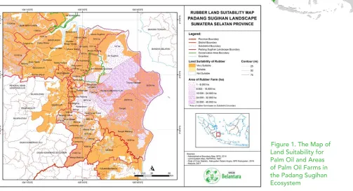
1. The Padang Sugihan Ecosystem (Suitable for Palm Oil Plantations)
Figure 1. The Map of Land Suitability for Palm Oil and Areas of Palm Oil Farms in the Padang Sugihan Ecosystem
Map Analysis: Refer to Figure 1. The Map of Land Suitability for Palm Oil and Areas of Palm Oil Farms in the Padang Sugihan Ecosystem.
Palm oil crops are one of the prima donna commodities grown by residents around the ecosystem. For instance in Muara Padang Sub-district, palms oils are planted by citizens in partnership with private companies, both by core partnerships and freelance partnerships.
Muara Padang Sub-district is prospective for joint development with the community because, in addition to the ease of communication, the people there are also adaptive to change that will improve their lives.
by PPKS (Palm Oil Processing Factory).
The emergence of cooperatives and NGOs that assist in the traceability of the products is an effort to make South Sumatra’s palm oil products competitive.
The Social-Economic Profile of the Padang Sugihan Ecosystem: The majority of the population in the Padang Sugihan Ecosystem are high school educated. 39.86% of its population is over five years old. The number of people with higher education is less than 1%.
There are about 293,700 of productive aged people who mostly work in the agricultural sector of rice and companion crops (41,16%) and plantations (23,78%). About 6.5% of the population work in the fisheries sector, in coastal villages such as the Cengal Sub-district, Sungai Menang Sub-district, Tulung Selapan Sub-district, Muara Sugihan Sub-district, and the Banyuasin I Sub-district. The rubber commodity remains the mainstay in the plantation sector of the Padang Sugihan Ecosystem, both in the OKI Sub-district and Banyuasin Sub-district. There are also small parts of areas that are planted with palms, coconuts, cacaos, and coffees (Belantara, 2017).
Conclusion: The ecosystem of Padang Sugihan is a province that is challenging in palm oil community development. The cultural, social and adaptive approach is one of the benchmarks of success for the capacity building program in South Sumatra Province. Government support for a conducive palm oil industry is one of the benefits of the program’s success.
The plantation commodities in the Padang Sugihan Ecosystem
Regencies/Cities Cacao Rubber Palm Oil Coconut Coffee Others
Ogan Komering Ilir 396.20 153,237 12,845.00 3,895.00 277.43 4.00
Banyuasin 216.21 71,522.90 26,518.28 24,234.15 470.36 10.10
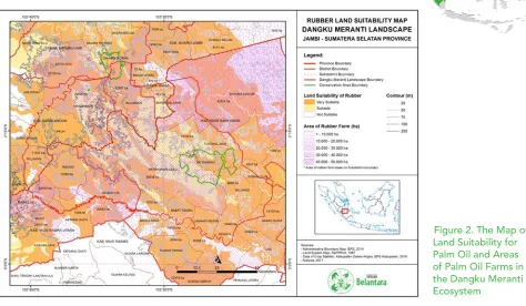
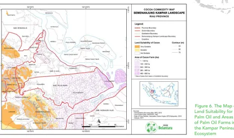
2. Dangku Meranti Ecosystem - (Very Suitable for Palm Oil Plantations)
Figure 2. The Map of Land Suitability for Palm Oil and Areas of Palm Oil Farms in the Dangku Meranti Ecosystem
Map Analysis: Refer to Figure 2. The Map of Land Suitability for Palm Oil and Areas of Palm Oil Farms in the Dangku Meranti Ecosystem.
The area around the Dangku Meranti Ecosystem, especially Musi Banyuasin Regency and Muaro Jambi Regency, are areas with lots of palm oil plantations. In both regencies, the private sector’s plantations grow, develop and partner with the communities.
The Musi Banyuasin Regency is also the first area to conduct a palm replanting program through the Plantation Fund Management Agency (BPDP) in cooperation with BNI (Bank Nasional Indonesia) in the sub-district of Sungai Lilin and was attended by President Joko Widodo. This ecosystem still needs support for capacity building for the community’s palm oil replanting to be successful. The presence of multinational companies engaged in palm oil is also a strong point to the success of the community’s revenue capacity building program.
regencies in Jambi Province, and two regencies in South Sumatra Province (Musi Rawas Regency, and Musi Banyuasin Regency). In total, there are 22 sub-districts which are partially or entirely within the boundaries of this ecosystem. 939,363 people populate this ecosystem, with the majority being Muslims.
Regarding education, 21.41% of Dangku Meranti Ecosystem’s populace have not graduated primary school, 32.72% have graduated from primary school, 17.53% have graduated middle school, and 17.20% have graduated high school.
The types of crops cultivated by the smallholder farmers are rubber, palm oil, cacao, coconut, and coffee. There are 520,313.14 hectares of rubber smallholders, and 203,874.90 hectares of palm oil smallholders. Cacao crops are dominant in Muaro Jambi Regency, while coconut crops are dominant in Musi Banyuasin Regency. Coffee is grown in Musi Rawas Regency and covers an area of 2,296.28 hectares (Belantara, 2017).
Conclusion: A regency around the ecosystem of Dangku Meranti has started palm oil replanting and could potentially be the development of a traceability program for CPO and PKO products that come from the community.
The plantation commodies in the Dangku Meranti Ecosystem
Regency/city
Smallholder Farmers Plantation Area (hectare)
Gambir
Cacao
Rubber
Palm Oil
Coconut
Coffee
Areca nut
Musi Rawas
-
408.81
170,253.69
26,753.84
206.56
2,296.28
2.66
Musi Banyuasin
108,25
295.59
145,655.74
60,829.44
3,128.60
21.53
4.44
Sarolangun
-
104.60
84,716.85
17,301.61
50.90
15.67
3.07
Batang Hari
-
100.36
68,657.74
35,187.74
143.53
5.48
13.51
Muaro Jambi
-
1,821.72
48,658.52
56,070.80
542.43
6.87
93.41
Kota Jambi
-
95.47
2,370.59
7,731.47
461.69
6.50
79.08
Total
108,25
2,826.55
520,313.14
203,874.90
4,533.70
2,352.33
196.17
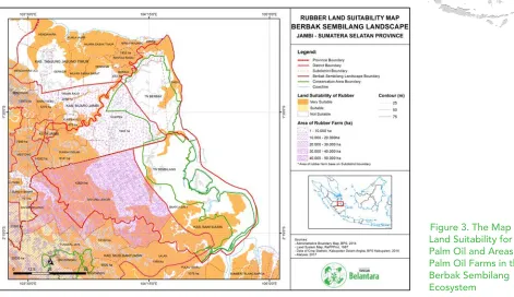
3. Berbak Sembilang Ecosystem – (Suitable for Palm Oil Plantations)
Figure 3. The Map of Land Suitability for Palm Oil and Areas of Palm Oil Farms in the Berbak Sembilang Ecosystem
Map Analysis: Refer to Figure 3. The Map of Land Suitability for Palm Oil and Areas of Palm Oil Farms in the Berbak Sembilang Ecosystem.
The Social-Economic Profile of the Berbak Sembilang Ecosystem: The percentage of Berbak Sembilang Ecosystem’s population that has not completed primary school is 20.56%, 31.59% graduated primary school, 16.71% graduated middle school, 18.93% graduated high school, less than 5% achieved higher education. Of the 272,208 working aged people, 29.10% works in the plantation sector, 16.88% works cultivating rice and companion crops, 4.10% works in the fisheries sector, 16.25% works in the trade sector, 8.57% works in the public service sector, 5.76 works in construction, 4.08% in transportation and warehousing, 3.67% works in education, and 3.05% works in the processing industry.The prominent plantations in the Berback Sembilang Ecosystem are coconuts, rubber, and palm oils. Transmigrants, utilizing two hectares of land granted by the government initially planted coconuts; by time, with palm oil and rubber companies coming in, and with the development of their plantations, coconut plants were later replaced by palm oil and rubber (Belantara, 2017). Conclusion: Residents in the Berbak Sembilang Ecosystem depend on the palm oil industry as one of their source of employment. Aside from being a source of employment opportunities, the palm oil companies also provide market access for the community to sell its palm products.
Plantation commodity in the Berbak Sembilang Ecosystem
Plantation Crops
Plantation areas by farming household (hectare)
Total area (ha) Muaro Jambi East Tanjung Jabung Jambi City Musi Banyuasin Banyuasin
Rubber 48,658.52 104.24 2,370.59 145,655.74 71,522.90 276,312.00
Source: 2013 Agricultural Census of South Sumatra Province, 2014 Agricultural Census of Jambi Province (South Sumatra Province’s Central Bureau of Statistics, Jambi’s Province Central Bureau of Statistcs.
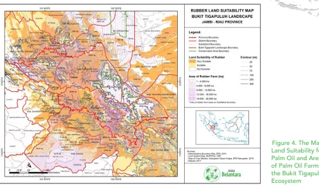
4. Bukit Tigapuluh Ecosystem – (Suitable for Palm Oil Plantations)
Figure 4. The Map of Land Suitability for Palm Oil and Areas of Palm Oil Farms in the Bukit Tigapuluh Ecosystem
Map Analysis: Refer to the Figure 4. The Map of Land Suitability for Palm Oil and Areas of Palm Oil Farms in the Bukit Tigapuluh Ecosystem.
Oil palm plantations around Bukit Tigapuluh National Park area, both in Jambi Province and Riau Province have their respective history and developmental characteristics. Both in Riau and Jambi, the inhabitants of its ecosystem consist of indigenous people and migrants. People in Bukit Tiga Puluh area rely heavily on commodities which prices are affected by world markets, such as cacao, palm, coffee, and rubber.
Capacity building in this region requires good coordination with government stakeholders so that each step of community development does not stimulate community pressure into protected areas or limited areas. Land status awareness needs to be given to the community so that the legality of the land and community activities would also take care the environment of the region. Animal and natives (Orang Rimba –the jungle people) conflicts with cultivated land require major attention in development activities.
years and older graduated primary school (32%), and about 23% did not or have not graduated primary school. 18% of the population graduated middle school, and 15% of them graduated Highschool. There are only about 2.1% bachelors or postgraduates.
There are about 303,170 of productive aged people. The majority of them work in plantations (62.37% or 189,102 people), which far exceeds other sectors, such as trade (11.31%), community services (6.66%), and education (4.82%). The percentage of those working in agriculture (rice or companion crops) is tiny, 5.22% (15,204). The significant amount of workers in the plantation sector shows that this sector can absorb labor, especially smallholder farmers.
Based on the Agricultural Census of 2013 it is seen that the smallholder farmers in and around the landscape rely on three primary commodities, which are rubber, palm oil and coconut (Belantara, 2017).
Conclusion: Development programs around Bukit Tiga Puluh areas, whether private or non-governmental organizations, should be appropriately recorded. Community development measures should be monitored in order for them not to press into the area after knowing about potential commodities.
Plantation Commodities in the Bukit Tigapuluh Ecosystem
Regency/City
Plantation Areas (hectares)
Clove Cacao Rubber Palm Oil Coconut Coffee Pepper Areca nut Sago Others
Kuantan Singingi 7.01 149.26 47,925.25 36,469.14 288 10.15 0.05 8.62 0.13 0
Indragiri Hulu 0.26 533.94 46,810.77 79,434.38 262.05 14.94 0.01 182.84 0 0.5
Indragiri Hilir 5.3 93.1 3,939.32 61,178.64 210,107.10 468.58 0.17 10,055.61 1,108.03 13.89
Tanjung Jabung Barat 0 77.22 9,754.04 54,711.50 35.587.47 3,792.77 3.18 16,712.97 0 0
Tebo 0.77 317.52 109,203,.3 28,019.47 189.31 27.17 0.16 7.16 0 0
Bungo 6.27 214.69 78,753.80 34,655.78 134.2 489.63 0 10.49 0 0
Total areas (Ha) 19.61 1,385.74 296,386.90 294,468.91 246,568.14 4,803.25 3.57 26,977.69 1,108.15 14.39
5. Kerumutan Ecosystem – (Suitable for Palm Oil Plantations)
Figure 5. The Map of Land Suitability for Palm Oil and Areas of Palm Oil Farms in the Kerumutan Ecosystem
Map Analysis: Refer to Figure 5. The Map of Land Suitability for Palm Oil and Areas of Palm Oil Farms in the Kerumutan Ecosystem.
Palm oil plantations in the Kerumutan Ecosystem area are still being opened with traditional techniques. The residents burn land to open oil palm plantations due to the low cost. The process of land clearing by burning land is already a culture of farmers in the region. It is because of this culture that the government began to circumvent the practice of opening land by burning and use methods that do not use burning. The threat of community palm plantations to protected areas in Kerumutan becomes providing awareness a necessity. Also, capacity building for GAP (Good Agricultural Practice) will increase production by intensifying existing land.
The population of productive aged people in the Kerumutan Ecosystem is about 323,924 people, with the majority working in plantations (45.30%); the rest work in the trade sector (11.27%), community services (9.22%), and rice and companion crops (9.09%). Besides those, the percentage of workers in other sectors is not very prominent, the processing industry (5.55%), construction (3.39%), fishery (2.04%), and forestry (1.04%).
The majority of people aged five years and over have completed primary school (33.91%), although 21.93% have not or did not finish primary school. More than half of the Kerumutan Ecosystem educational level is primary education. Those who have graduated middle school or it’s equivalent is as much as 17.16 %; high school/equivalent graduates are 16.22%.
Based on the dedicated land area and the type of plant, plantation commodities are the mainstay of the population in the Kerumutan Ecosystem, especially palm oils, with a land area of 546,094 hectares, and coconuts with the land area of 461,031 hectares. The most massive coconut plantation is located in Indragiri Hilir Regency, whereas many palm oils are grown in Indragiri Hilir Regency and Pelalawan Regency (Belantara, 2017).
Conclusion: Land encroachment by burning is a potential problem in constructing farmer development programs. Capacity-building programs for GAP are necessary to enable the community’s land to be intensified.
Plantation Commodities in the Kerumutan Ecosystem
Regency/City
Plantation areas and type of crops (hectares)
Rubber
Coconut
Palm Oil
Coffee
Areca nut
Indragiri Hulu
61,372
1,828
11,897
348
383
Indragiri Hilir
5,369
442,335
228,052
1,237
16,384
Pelalawan
29,074
16,868
306,145
1,289
53
Total
95,815
461,031
546,094
2,874
16,820
Source: 2013 Agricultural Census of South Sumatra Province, and 2014 Agricultural Census of Jambi Province (South Sumatra Province’s Central Bureau of Statistics, Jambi Province’s Central Bureau of Statistics)
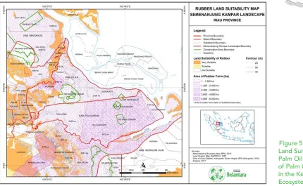
6. Kampar Peninsula Ecosystem – (Not Suitable for Palm Oil Plantations)
Figure 6. The Map of Land Suitability for Palm Oil and Areas of Palm Oil Farms in the Kampar Peninsula Ecosystem
Map Analysis: Refer to Figure 6. The Map of Land Suitability for Palm Oil and Areas of Palm Oil Farms in the Kampar Peninsula Ecosystem.
Palm oil plantations in this ecosystem grow massively and even threaten the largest peat dome of Southeast Asia. The sustainability and status of the land in the vicinity of the Kampar Peninsula Ecosystem for palm oil is also in doubt. Land clearing by private companies stimulates the communities to encroach forests to clear land for palm oil and HTI (Industrial Forest Plantation). Given the peat dome in this region and the resulting drainage causing subsidence, this area is not suitable for palm oil plantations, and funded activities for managing capacity development for both intensification and extensification are not feasible.
The number of productive workers in the Kampar Peninsula Ecosystem’s is about 93,472 people. Most of them work in the plantation sub-sector (37.28%), the trade sector (12.28%) and social services (11.33%). There are about 7.8% employed in manufacturing, 5.49% in construction, and 5.31% in the education sector.
Population groups who work in the agricultural sector (rice and companion crops) only amount to 4.13%. The plantation sub-sector is the pillar of most people within the Kampar Peninsula ecosystem. Outside the number of people working in plantation companies, the 2013 Agricultural Census (Central Bureau of Statistics of Riau, 2014) show that at the smallholders level, palm oil has become the most widely planted commodity on their lands. The area of land planted with palm oil reached 171,191.86 hectares, which amounts to five times the area of land planted with rubber, about 34,102.14 hectares (Belantara, 2017).
Conclusion: Peat domes and aspects that cause forest fires due to peatland drainage are reasons that cause this Ecosystem to be irrelevant concerning sustainability.
Plantation commodity in the Kampar Peninsula Ecosystem
Regency
Plantation/cultivation Areas (hectares) by smallholders
Cacao Rubber Oil palm Coconut Candlenut Coffee Areca nut Sago
Pelalawan
31.68
24,993.90
76,837.62
9,481.36
21.47
60.35
96.12
521.20
Siak
77.04
9,108.24
94,361.24
1,655.95
0.00
12.75
42.45
264.08
Total (Ha)
108.72
34,102.14
171,198.86
11,137.31
21.47
73.09
138.57
785.28
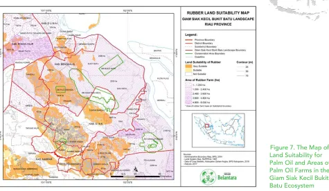
7. Giam Siak Kecil Bukit Batu Ecosystem – (Suitable for Palm Oil Plantations)
Map Analysis: Refer to Figure 7. The Map of Land Suitability for Palm Oil and Areas of Palm Oil Farms in the Giam Siak Kecil Bukit Batu Ecosystem.
The Giam Siak Kecil Bukit Batu Ecosystem, also known as a biosphere reserve is the government’s effort to save the biodiversity in this ecosystem. This region is a beautiful peat forest and can be used for an integrated research site for peat ecosystem research.
Palm oil plantations in this ecosystem are being monitored and strengthened for law enforcement. Palm oil fields that are close to protected areas and peat that have no permits are planned to be eliminated by the local government. Even so, this region has smallholder farmers in legal areas which partners with large palm oil companies that have plantation concessions in this region. The capacity buildings that can be done in this area are legal awareness, the legality of things, farmers organization, and GAP (Good Agriculture Aspect) that are in accordance with palm oil companies standard.
The Social-Economic Profile of the Giam Siak Kecil Bukit Batu Ecosystem: The Giam Siak Kecil-Bukit Batu (GSKBB) Ecosystem is adjacent to the Senepis Ecosystem and Kampar Ecosystem, in fact, there are two regencies/cities in the Senepis Ecosystem that are part of the GSKBB Ecosystem.
The majority of the population are Muslims with native Malay culture. The transmigrants from Java Island, Kalimantan Island, Sulawesi Island and the Riau’s surrounding areas make up for the diverse ethnic population of the GSKBB Ecosystem.
Based on the level of education, people aged five years and over have had a high school education or equivalent. From about 438,030 people, the percentage of people aged 15 years and above: 26.02% work in the plantation sector, 17.23% work in trade, 12.51% in community service, 7.66% in construction and 7.14% work in the manufacturing industry. People who work in agriculture, livestock, or fishery is only about 1-3% of the total workforce.
The 2013 Agriculture Census shows that the largest amount of planted commodities are palm oil, rubber, and coconut; a contrast from areas planted with crops such as rice, companion crops, and horticulture crops. In the same year, the total of rice fields in the GSKBB Ecosystem only amounts to 37,601 hectares of rice fields and agricultural fields. While, the total area planted with maize and cassava is only about 15,611 hectares (Belantara, 2017).
Conclusion: Surveys are needed to get enough data to operate around the ecosystem of Giam Siak Kecil Bukit Batu. Selecting smallholders around the Giam Siak Kecil Bukit Batu ecosystem requires consideration with stakeholders regarding area owners. Capacity building that can be done and are quite significant is legal awareness, the legality of things, farmers organization and the GAP (Good Agriculture Practice) with palm oil companies that are the off-takers.
Plantation commodities in the GSKBB Ecosystem
Regency/City
Plantation Areas (Ha)
Rubber Coconut Palm Oil Areca Coffee Cacao
Siak 16,129 1,657 287,782 259 140 66
Kampar 101,966 1,806 387,263 99 17 286
Bengkalis 3,786 12,684 198,642 1,005 343
-Rokan Hilir 2,639 5,469 273,145 117 20 260
Pekanbaru 2,926 6 10,745 - - 13
Dumai 2,355 1,929 36,345 103 29 26
Total 129,801 23,551 1,193,922 1,583 549 651
Source: 2013 Agricultural Census of Riau Province (Riau Province’s Central Bureau of Statistics, 2014)
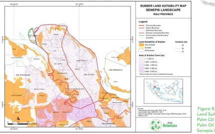
8. Senepis Ecosystem – (Suitable for Palm Oil Plantations)
Map Analysis: Refer to Figure 8. The Map of Land Suitability for Palm Oil and Areas of Palm Oil Farms in the Senepis Ecosystem.
The Senepis Ecosystem is an ecosystem with palm oil as the primary plantation crop. Besides planting palm oils, the community also plants companion crops. Some farmers also open rice fields on unused land. Coconut copra is also a crop that they plant on the sidelines between their companion crops and their rice fields. The presence of coconut collectors and “Toke” that supply the coconut industry keeps the people in Senepis in maintaining their coconut palms. Palm crops for the people of Senepis are one of the primary commodities of their plantations.
Enrichment for the community in this ecosystem can be land modification techniques, organic farming, and crop intensification and diversification. The diversification of crops can be adjusted to high-value crops. Empowering peoples awareness to wildlife conflicts is also an important concern for smallholders in the ecosystem of Senepis.
The Social-Economic Profile of the Senepis Ecosystem: The total population of all the sub-districts in the Senepis Ecosystem is 371,701. The largest population is Dumai Barat Sub-district (89,978 inhabitants), and the least populated area is Batu Hampar Sub-district (7,213 inhabitants).
The majority of the population are Muslims, while the ethnicity is quite diverse. The natives of the Senepis Ecosystem are Malay. Tribes that have inhabited this region for years are the Minang tribe, Javanese, Bugis, and Chinese. The economic development of Rokan Hilir Regency and Dumai City has encouraged the entry of migrant communities to work in various business sectors.
The majority (106,768) of the population have graduated primary school or its equivalent. People of over 15 years old and working is 126,889. They mostly work in the plantation sector (32.58%), growing rice crops and companion crops (12.91%), trade (12.88%) and community services (13.91%). The percentage of the people working in forestry, fishery, and mining as a whole is around 6.1%.
By comparison, more areas are planted with plantation crops than agricultural crops, such as rice or horticulture. Palm oil is the most popular commodity and has more plantation areas compared to rubber, coconut or cacao in the Senepis Ecosystem (Belantara, 2017).
Conclusion: Community plantations in this area need awareness in handling conflicts with animals. There needs to be an understanding to avoid illegal hunting, especially of protected animals; and the ability to manage the animals that enter the plantations.
Plantation commodities in Senepis Ecosystem
Type of crops
Plantation areas (ha)
Rokan Hilir Regency Dumai City Total
Farming
Wet rice field 12,271 244 12,515
Dry rice field 14 194 208
Corn 510 41 551
Cassava 316 223 539
Plantation
Rubber 2,926 2355 5,281
Coconut 5,469 1,929 7,398
Palm Oil 273,145 36,345 309,490
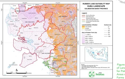
9. Kubu Raya Ecosystem – (Not Suitable for Palm Oil Plantations)
Map Analysis: Refer to Figure 9. The Map of Land Suitability for Palm Oil and Areas of Palm Oil Farms in the Kubu Raya Ecosystem.
The Kubu Raya Ecosystem is surrounded by HTI plantations (industrial forest plantations) and palm oil plantations, which are owned by private companies and ordinary people. The ecosystem of Kubu Raya has transmigrant villages that can absorb new skills and knowledge in community empowerment.
Transportation is the main hurdle in these villages because the main route for transportation goes through the Kapuas River. Private companies that open their land around the Kubu Raya Ecosystem get an additional supply of palm oil FFB (Fresh Fruit Bunch) via boats; both small and large boats, which are owned by smallholders.
The local government will surely welcome a company’s support for efforts in maintaining peat in the plantations in the Kubu Raya Ecosystem. Good cooperation between companies and the government can empower indigenous people and migrants. The empowerment that can be done in this area can be in the form of GAP (Good Agriculture Practice), land modifications, legal aspect of the land, and awareness to protect mangroves.
The Social-Economic Profile of the Kubu Raya Ecosystem: The population in the Kubu Raya Ecosystem is 285,920 people or about 6.5% of the total population of West Kalimantan, which is 4,395,983.
According to the Indonesia Central Bureau of Statistics’s 2014 data of West Kalimantan, about 46.5% of the Kubu Raya Ecosystem’s population work in the plantation sector, a majority compared to other industries. Even so, there are also many of who work in the agricultural sector of rice and companion crops. The percentage of the people who work in construction, transportation, forestry, and mining sectors is below 10%. Besides those, the sectors of finance, transportation, electricity and gas, education services, and social services constitute 8.7% of the population’s work sector.
Based on the educational level, the average people in the Kubu Raya Ecosystem have a basic level of education. In essence, there are those who have or are in the process of completing primary school (32%) and those who have completed primary school (30%). Middle school/equivalent graduates are 11%, while High School/equivalent is about 7%. The percentage of people with higher education (diploma, undergraduate, postgraduate) are still below 2%.
Based on the type of crops grown, rubber and palm oil are the most cultivated commodity by smallholder farmers. Based on the 2013 Agricultural Census of 2013 (West Kalimantan Central Bureau of Statistic, 2014), the amount of land planted with rubber reached 254,096.97 hectares, while the total land areas planted with palm oil reached 101,090.45 hectares. The types of crops grown by the people in Sanggau Regency are mostly palm oil and rubber, while in Kubu and North Kayong, it is rubber, coconut, and coffee. (Belantara, 2017).
Conclusion: Developing palm oil for smallholders in the Kubu Ecosystem is a challenge because it is a peat-dominated ecosystem; the fastest route of transportation is by using waterways to reach the sites. Communities are in great need of assistance to improve their GAP (Good Agriculture Practice) capacity and require diversification of products to be planted on their land.
Plantation commodities in Kubu Raya Ecosystem
Regencies
Plantation areas /cultivation (ha)
Clove Cacao Rubber Palm Oil Coconut Coffee Pepper Areca Sago
North Kayong 11.74 4.63 8,218.00 252.21 3,382.50 1,020.94 22.43 6.26 -
Kubu Raya 52.31 62.50 30,392.37 3,999.41 23,209.28 4,053.33 223.10 592.04 296.97
Sanggau 48.65 951.43 121,213.67 67,400.43 670.73 10.42 1,168.20 0.02 1.44
Ketapang 3.50 94.02 94,272.93 29,438.39 1,278.97 372.00 4.79 0.98 0.34
Total (ha) 116.19 1,112.58 254,096.97 101,090.45 28,541.49 5,456.69 1,418.51 599.30 298.75
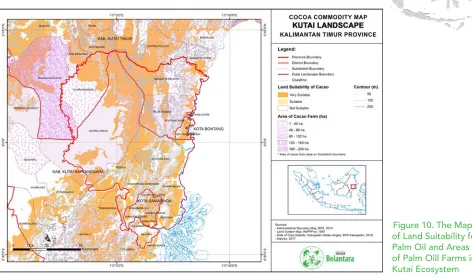
10. Kutai Ecosystem – (Not Suitable for Palm Oil Plantations)
Map Analysis: Refer to Figure 10. The Map of Land Suitability for Palm Oil and Areas of Palm Oil Farms in the Kutai Ecosystem.
Palm oil plantations in the Kutai Ecosystem are growing in competition with mining concessions. The threat of palm oil plantations to the Kutai National Park is a significant factor in managing the ecosystem. Smallholders that rise due to the investment of oil companies in this region’s ecosystem stimulate the communities to expand and open new plantation areas. By looking at the Map of Land Suitability, it can be inferred that the Kutai Ecosystem is unsuitable for palm oil plantations.
The land clearing for palm oil plantations in the Kutai Ecosystem has contributed to new land modification techniques that can make the planted crops able to live and bear fruit. According to data from Disbun Kaltim (East Kalimantan’s Plantation Service), the land clearing for palm oil plantations in East Kalimantan started since 1982.
For roughly 35 years, palm oil plantations and smallholder farmers have learned to overcome the challenges of the land around the Kutai Ecosystem. The smallholder farmers still need assistance in obtaining additional income from the diversification of farming and livelihood. Currently, they grow fruit and pepper crops in their yards.
The Social-Economic Profile of the Kutai Ecosystem: The population of the sub-districts within the Kutai Ecosystem is 1,287,853 people and are predominantly Muslim (91.35%). The highest population density is in Samarinda Seberang Sub-district (9,142 inhabitants/km2), while the lowest population density is in Muara Ancalong Sub-district, which is 4.6 people/km2.
Based on ethnicity, people in the Kutai Ecosystem come from the native ethnicities in the region, i.e., Kutai and some Dayak sub-ethnic groups, such as the Kenyah. However, many residents are also of Bugis and Javanese tribes, which came from transmigration programs since the 1970s.
Based on a person’s last level of education, the percentage of the population aged five years and over who has graduated high school/equivalent is 29.1%, those with only primary school/equivalent education is 22.9%, middle school/equivalent is 18.2%, and those who did or have not finished primary school amounts to 17.8%. While the percentage of people with bachelor degrees or higher is higher than people with I-III diplomas. There are approximately 561,082 productive-aged people in this Ecosystem. The majority work in trading (17.6%), community services (12.6%), mining and quarrying (10.1%), construction (7.4%), and rice cultivation and companion crops (7.1%). Approximately 8.9% of workers work in the hospitality and restaurants, financial services and insurance, and educational services. In contrast to other Ecosystems, the plantation business in the Kutai landscape is low (3.6%). Based on the 2013 Agricultural Census, the area of plantation cultivated by smallholder farmers in the regencies/cities in the Kutai Ecosystem is not much, including the East Kutai Regency and Kutai Kartanegara Regency where most of the people work in agriculture and plantation sectors. Rubber and palm oils as a whole have the largest planting area in this Ecosystem, rubber reaching 38,942 hectares and palm oil reaching 38,938 hectares. Even so, the total area is far above the areas of land planted with coconut, cacao or pepper (Belantara, 2017).
Conclusion: Plantations and farmers in East Kalimantan Province have adapted to limited land conditions by discovering land modification practices. Smallholder farmers increase income by planting crops other than palm oil to supplement income.
Plantation commodities in Kutai Ecosystem
Regencies/cities
Plantation areas and type of crops managed/cultivated by smallholders
Sugar Palm Clove Cacao Rubber Palm Oil Coconut Candlenut Coffee Pepper Others
COST FOR A PALM OIL
PLANTATION PER YEAR
The Cost Estimate of Commodity Development Programs
(Optional)1. Farmer awareness for GAP (Good Agricultural Practices) is US $ 120 per person per year.
2. Construction of an urban farming demonstration plot for the differentiation of agricultural products, US $ 80 per person per year.
3. Integrated Farming Program (farming and fishery), US $ 650 per person per year.
4. Management program, US $ 1,700 per month.
REFERENCES
Administrator.2014.Pertumbuhan Areal Kelapa Sawit Meningkat. www.ditjenbun.pertanian.go.id/ berita-362-pertumbuhan-areal-kelapa-sawit-meningkat.html.Ditjenbun.Jakarta. diakses tanggal 13-11-2017 jam 11.07
Anonym.2018. Ke Mana Minyak Kelapa Sawit Indonesia Diekspor. https://databoks.katadata. co.id/ datapublish/2017/11/29/kemana-minyak-kelapa-sawit-indonesia-di-ekspor.Diakses 01-02-18 17:59
Anonymous.2014. http://disbun.kaltimprov.go.id/statis-35-komoditi-kelapa-sawit.html diakses tanggal 27/11/2017 jam 23.26
Belantara, Yayasan.2017.Panduan Yayasan Belantara: Rencana Pengembangan Konservasi di Area Hibah Target di Sumatera dan Kalimantan. Yayasan Belantara. Jakarta Pusat.
BPS.2002-2017. Jambi dalam angka 2002-2017.Badan Pusat Statistik.Jambi
BPS.2002-2017. Sumatra Selatan dalam angka 2002-2017.Badan Pusat Statistik.Sumsel
BPS.2009-2017.Kalimantan Timur dalam angka 2009-2017.Badan Pusat Statistik.Kaltim
BPS.2008-2016. Kalimantan Barat dalam angka 2008-2016.Badan Pusat Statistik.Kalbar
BPS.2008-2015.Riau dalam angka 2008-2015.Badan Pusat Statistik.Riau
Zaenudin, Lutfi.2017.Laporan BPS : Ekspor Nonmigas Naik 6,37%. www.finansial.bisnis.com/read/ 20170615/9/663106/laporan-bps-ekspor-nonmigas-naik-637. Diakses tanggal 13-11-2017 jam 10.54
Hasan, Fadhil. 2017. Siaran Pers GAPKI: Refleksi Industri Kelapa Sawit 2016 dan Prospek 2017. www. gapki.id/refleksi-industri-kelapa-sawit-2016-prospek-2017/.GAPKI.Jakarta. diakses tanggal 13-11-2017 jam 11.11.