Yayasan Bersama Lestarikan Nusantara (“Yayasan Belantara”) is an Indonesian grant-making institution formed in 2014 with the goal of delivering wide-ranging community and conservation results. It takes its name from the Indonesian word ‘Belantara’ which means wilderness or pristine forest.
Belantara primary focus is to allocate grants to support restoration, protection, conservation of endangered species (specifically Sumatran Tiger, Sumatran Elephant, as well as Sumatran and Bornean Orangutan), Institutional development,
and community development and empowerment initiatives in Conservation Area, Production Forest, Protection Forest, and Social Forestry on the ten specified grant
distribution areas across five provinces on the islands of Sumatra and Kalimantan (Indonesian Borneo).
Working with local communities, governments, the private sector and NGOs, Belantara relies on a multi-stakeholder approach to better inform decision-making
when addressing resource management problems. As the Essential Ecosystem Areas (KEE) stretch across the grant distribution areas, a coordinated response between all stakeholders for the effective management and preservation of critical
ecosystems is required.
As an independent foundation, Belantara aims to work with all parties that shares its goals, coordinating and collaborating with partner projects within each of its ten specified grant distribution areas. Belantara aims to ensure that existing initiatives are aligned, minimizing the risk of projects overlapping while maximizing
information and data sharing.
Co-founder Asia Pulp and Paper significantly contributed in getting the Foundation off the ground, providing substantial financing. Additional financial resources are being raised from the public and private sectors, while investment de-risking
COCONUT
HISTORY & FACTS
Coconuts have played an essential role in the lives of
Indonesia’s rural communities since ages. In Indonesia, the
coconut tree is used from the tip of the tree to its roots.
The dependence and usefulness of coconuts and the
effect it has in peoples lives have made the coconut
the symbol of the Indonesian scout (Pramuka).
Coconut plants are native to the tropics, i.e., areas
located along the equator. There are several
theories of opinion on where coconuts originated.
The first opinion theorizes that because there are
vasts coconut forests in South America, coconuts
originated from that region. The second opinion
speculates that coconut plants come from the tropics
due to the discovery of Pliocene era relics of coconut
palm tree fossils in New Zealand (Warisno, 2003).
The development of coconut plants in Indonesia has been going on for hundreds of years. Coconut yields (i.e.,
coconut oil) are traded from Asia to Europe since the 19th-century. The coconut oil trade between Ceylon (now
Sri Lanka) and the UK, and between Indonesia and the Netherlands started since the establishment of the VOC
(The Dutch East India Com pany). Around 1886, the Dutch opened a coconut plantation on the island of Talise
and Kinabuhutan, North Sulawesi, Indonesia. Before the outbreak of the second world war in 1939, Indonesian
copra (dried coconut kernels) exports ranked fourth after oil, sugar, and rubber. After the Second World War,
Indonesia’s copra exports increased and was ranked third from the six primary export commodities, which are
rubber (smallholder rubber and rubber plantations), palm oil (palm oil and palm kernel oil), copra, tobacco,
tea, and sugar. Coconuts have a substantial contribution to the people’s economy and Indonesia’s source
THE ECONOMICS OF
INDONESIAN COCONUT
PRODUCTION
According to data released by the Directorate General
of Plantation of the Ministry of Agriculture in 2015, the total area of coconut plantations in Indonesia is more
than 3,585,599 hectares. The data consists of 3,548,883 hectares of smallholder plantations, 3,874 hectares of state plantations, and 32,842 hectares of private plantations. In 2015 Indonesia exported 1,826,310 tons of coconuts, which accounted for US $ 1.190,672 Billion of foreign exchange income.
The foreign exchange earning from coconut exports is
currently ranked number three after palm oil and rubber.
Head of Center for Data and Information System of the Ministry of Agriculture, Suwandi revealed that coconut is one of the leading commodities of foreign exchange contributors. The foreign exchange earnings of coconut exports based on the Central Bureau of Statistics (BPS) data from January 2017 to August 2017 amounts to US $ 899.47 million, while imports of coconut derived products were just US $ 8.65 million. Indonesia is also the worlds first, and largest exporter of coconut endocarps
(meat inside the inner shell), which accounts for 59% of
the worlds total coconut export in that form. Indonesia’s coconut export destination countries include the United States 19.87%, China 16.10%, Netherlands 11.75%, Thailand 10.16%, Malaysia 9.7% and South Korea 7.26%
(Yunita, 2017).
By 2016 Indonesia has become the largest coconut
producing country in the World. With a coconut
production reaching 18.3 million tons, Indonesia has
surpassed the Philippines’s 15.4 million tons, and India’s
11.9 million tons of coconut production (Katadata,
0 5 Million 10 Million 15 Million 20 Million
The coconut plant requires an annual temperature of 21 ° C - 27 ° C, and a daily average temperature of 25 ° C to grow. Coconut plants grow well at an elevation of 200m - 600m above sea level. Even so, coconuts that are grown below 200 m above sea level is capable of producing faster and contain high levels of oil production. Coconuts are tropical plants and can optimally produce if planted within the 15th parallel north - 18th parallel south. Outside of that region, coconut plants can grow, but cannot bear fruit. The minimum rainfall required by coconuts ranges between 1300 mm per year to 2300 mm per year with even distribution throughout the year.
COCONUT
Types of Coconuts
Humans have cultivated coconuts since ages. There are many types of coconuts and are commonly produced by cross-pollination. Coconut plants are classified based on its
stature and breeding behavior; the color, shape, and size of the fruit; and some other unique properties.
1.
Based on the stature and breeding behavior
a. Tall Palms
(Typica)
The Tall Palms (Typica) varieties start to bear fruit when they are quite old, which is
about 6-8 years. A Typica’s age can reach up to 100 years or more, with a
productive period of 50 years or more. The ratio of yield per
year that this coconut variety can produce is promising.
The fruit color can be green, brown, to brownish-red,
with large fruits (2 kg-2.5 kg), and can contain about 0.5 kilograms of meat and 0.5 liters of water. Each grain can produce about 200 g- 300 g of copra and 132 g of oil. It has tall crop stems
(about 35 meters), which grows straight up like a pole, and is slightly enlarged at the base. Coconut plants that are grouped into the Typica variety are Green Coconuts
(C. viridis), Red Coconuts (C. rubescens), Bali Coconuts (var. macrocarya), Sweet Coconuts (var. sakarina), Ornamental Coconuts, and Halmahera
Coconuts among others.
b. Dwarf Coconuts
(Nana)
The Dwarf (Nana) varieties have a relatively
early flowering age, which is about 3 - 4 years
old and can reach up to 50 years old, with a productive period of 25 years, but the fruit
yield per year is not steady. The color of the
fruit varies; it can be green, yellow or
orange. The fruit is small in size, and
weighs about 1.5 kg - 2kg (some are less than 1.5 kg), and contain about 0.4 kilograms of fruit and about 200 ccs of water. Each grain of coconut can produce about 150 of copra per grain,
and about 68% of it contains oil. The term “dwarf” does not refer to
the tree’s size but refers to the size in which it will begin to produce the
harvestable coconut. Dwarf varietes can
reach about 20 m tall, with the stem being straight from the bottom to the top,
2.
Based on the fruit color
Based on the color of the fruit, coconut plants can be divided into three groups.
a. Green Coconuts
(C. viridis)
Green colored coconut fruits are fruits of Tall Coconuts (Typica), a variety of coconut plants that is large, has a
tall stem, and large fruits. Typically, green coconut fruits
are used for offerings in traditional ceremonies or have its coconut water used as an antidote to overcome vomiting, dizziness, etc.
b. Red Coconuts
(C. rubescens)
Cocos rubescens have red or brown colored fruit skin
and are fruits of Tall Coconut (Typica), which has a
large and high stem. The fruit is round and large, and
contains high oil content.
c. Yellow Coconuts
(C. eburnea)Coconut fruits that are yellow colored are the fruits of
Dwarf Coconuts (Nana), a type of coconut plant that can begin to bear fruit at the age of three years old when the plant’s height reaches 1 m -1.5 m. Its stem size is not too big and not too high. While the fruit is round and small in size.
3.
`Based on the shape and size of the fruit
Based on the shape and size of the coconut fruit, coconut plants can be divided into two groups.
a. Large shaped and sized
b. Small shaped and sized
Coconuts that are small sized and shaped (Nana) includes Ivory Coconuts (var. eburnea), Sriwulan Coconuts, King Coconuts (var. regia), Puyuh Coconuts (var. pumila), Nias Coconuts, and others.
4.
Based on the Genotype
a. Tall varieties
(Typica),such as green, yellow and red colored coconuts.
b. Dwarf variety
(Nana),such as green, yellow and red coconuts.
c. Crossbreds, commonly known as hybrid coconuts,
with many variations
depending on the crossed varieties.
d. Abnormal coconuts, e.g., Kopyor Coconuts, branched coconut, or
Source: Central Bureau of Statistics, South Sumatra
province in figures (2007-2017)
GEOGRAPHIC AND CLIMATE
INFORMATION OF SOUTH
SUMATRA PROVINCE
There are three Belantara Grant Distribution Areas/Ecosystems in South Sumatra Province. The three ecosystems are (a) The Padang Sugihan Ecosystem, (b) The Dangku Meranti Ecosystem, (c) The Berbak Sembilang Ecosystem.
THE LAND CONDITION OF SOUTH SUMATRA PROVINCE
a. Soil State
South Sumatra consists of eleven types of soils, namely:
1. Organosol : Along the coasts and bogs
2. Lithosol : Along the edges of Lake Ranau’s rugged mountains region along Bukit Barisan’s
fault
3. Alluvial : Along the Musi River, the Lematang River, the Ogan River, the Komering River,
and the ridges of Bukit Barisan
4. Hydromorphic : In the marshes of Musi Rawas and Muara Enim 5. Gley Humus : Along the coast and in the swamps
6. Regosol : Around the east coast, along the edges and in the volcano cone of Lake Ranau’s
rugged mountains region
7. Andosol : In all of the new and old volcanic cones; commonly found 100 meters above sea
level
8. Redzina : Baturaja and its surroundings
9. Latosol : Commonly found in the drylands
10. Lateritic : In Martapura’s lowland
b. Climate
200 2004 2005 2006 2007 2008 2009 2010 2011 2012 2013 2014 2015 2016
Rainyday 1614
137 170 198 205 180 210 224 210 274
January February March April May June July August September October November December
There are two Belantara Grant Distribution Areas/Ecosystems in Jambi Province. The two ecosystems are (a) The Bukit Tiga Puluh Ecosystem, (b) The Berbak Sembilang Ecosystem.
THE LAND CONDITION OF JAMBI PROVINCE
a. Soil State
There are three land conditions in Jambi Province based on elevation: Lowlands, Midlands and Highlands.
Topography/Height (m/above sea level)
Area Total Area (ha)
Ha % Area/Regency
Lowlands (0-100) 3,431,165 67 Jambi city, West Tanjung Jabung Regency, East Tanjung Jabung Regency, Muaro Jambi Regency, Merangin Regency, Batang Hari Regency.
Midlands (100-500) 903,180 17 Parts of Sarolangun Regency, Tebo Regency, Parts of Batang Hari Regency, Sungai Penuh City Regency, Merangin Regency, Parts of West Tanjung Jabung Regency.
Highlands (>500) 765,655 16 Kerinci Regency, Sungai Penuh City, Parts of Merangin Regency, Parts of Sarolangun Regency, and parts of Bungo Regency.
Total 5,100,000 100
Source: Jambi Province’s Central Bureau of Statistics, Jambi Province cit RPJMP 2011-2015
a. Lowland : Dominant by lands full of water, susceptible to flood tides, many large and small
rivers flow through this area, its soil is dominated by low fertility gley, and its peat
areas are dominated by organosol.
b. Midland : Dominant with red-yellow podzolic soil, low fertility.
c. Highland : Dry highland that is dominant with plateus on the western part. Fertile alluvial soil could be found in the central parts of Kerinci Regency.
Source: Central Bureau of Statistics, Jambi (2004-2017) and
Jambi’s RPJMP (2011-2015)
a. 1. The Types of Soil and it’s Percentage
No.
Soil Type
Area (Ha)
%
1
Red-yellow Podzolic
2,036,386
39.93
2
Latosol
952,386
18.6
3
Low Gley Humus
547,830
10.74
4
Andosol
354,406
6.95
5
Organosol
308,338
6.05
6
Brown Podzolic +Andosol+Podzolic
275,652
5.40
7
Red-yellow Podzolic
236,343
4.63
8
Alluvial
199,553
3.91
9
Grey Hydomorphic
83,743
1.64
10
Latosol Andosol
60,032
1.18
11
Sea Swamp
42,951
0.84
12
Latosol + Litosol complex
2,380
0.05
Total
5,100,000
100.00
2007 2008 2009 2010 2011 2012 2013 2014 2015 2016
200 192 206 253 209 191 220 199 179 224
2500 3000 3500
rainfall rainy day
January February March April May June
July August September October November December
0
2007 2008 2009 2010 2011 2012 2013 2014 2015 2016
Source: Central Bureau of Statistics, Riau Province (2009-2016)
GEOGRAPHIC AND CLIMATE
INFORMATION OF RIAU
PROVINCE
In Riau Province, there are five Belantara Grant Distribution Areas/Ecosystem. The five areas are: a. Bukit Tiga Puluh Ecosystem; b. Kerumutan Ecosystem; c. Kampar Peninsula Ecosystem, d. Giam Siak Kecil Bukit Batu Ecosystem, e. Senepis Ecosystem
THE LAND CONDITION OF RIAU PROVINCE
a. Soil State
Based on elevation there are two land conditions in Riau Province: Lowlands and Highlands.
a. 1. Lowlands
No. Soil Type Area Rock Form Physiography
1 Organosol and Gley Humus 5,065,600 Alluvial Flatland
2 Grey Hydromop - Alluvial Flatland
3 Redy-Yellow Podzolic 2,156,000 Alluvial Flatland
4 Red-Yellow Podzolic 68,000 Alluvial Flatland
b. 2. Highlands
No. Soil Type Area Rock Form Physiography
1 Podzol 209,600 Sedimentary rock Flatland
2 Red-Yellow Podzolic - Sedimentary Rocks dan
Igneous Rocks
Foldland
3 Red-Yellow Podzolic (Complex) 218,200 Igneous Rocks Intrusion
4 Red-Yellow Podzolic Latosol and Litosol 94,800 Igneous Sedimentary Rocks and Metamorphic Rocks
2008
2009
2010
2011
2012
2013
2014
2015
2008 2009 2010 2011 2012 2013 2014
January February March April May June
July August September October November December
In West Kalimantan province, there is one Belantara’s Grant Area/Ecosystem, which is the Kubu Raya
Ecosystem.
Land Condition of West Kalimantan Province
a. Soil State
Based on its soil texture most of West Kalimantan Province consist of red-yellow podzolic soil (RYP), which spread over 10,5 million hectares or 71.28% of West Kalimantan Province. Furthermore, its soil also consists of OGH soil (organosol, gley humus) and alluvial soils, which amounts to 10.29% of West Kalimantan Province or 2 million hectares located in the coastal regencies.
a. 1. The Soil Types per Regency/City in the Ecosystem
No. Regency/City OGH Alluvial Regosol PMK Podzol Latosol
1 Landak Regency 138,152 323 0 761,014 49,621 41,600
2 Pontianak Regency 3,140 56,703 0 36,148 32,329 0
3 Kubu Raya Regency 170,584 462,437 0 33,765 25,468 6,266
4 North Kayong Regency 127,840 197,966 0 57,803 73,217 0
5 Pontianak City 3,600 7,180 0 0 0 0
b. 2. The Soil Textures of the Regencies and City in the Ecosystem
No. Regency/City Smooth Moderate Hard Turf Swamp Others
1 Landak Regency 37,017 707,211 246,682 114,214 0 0
2 Pontianak City 35,282 33,149 20,095 39,164 0 0
3 Kubu Raya Regency 403,139 716 0 292,665 0 0
4 North Kayong Regency 271,005 130,369 0 55,452 0 0
5 Pontianak City 7,860 2,920 0 1,100 0 0
2008
2009
2010
2011
2012
2013
2014
2015
01000 2000
3131.8
215 190 257 196 218 217 140
n/a
2008
2009
2010
2011
2012
2013
2014
2015
January February March April May June July August September October November December
Land condition of East Kalimantan Province
a. Soil State
East Kalimantan Province is dominated by red-yellow podzolic
soil, latosol, and lithosol types of soil, which spread over the
central, and northern parts of East Kalimantan. Other soil types
are organosol, latosol, and red-yellow podsolic with low fertility.
Source: Central Bureau of Statistics, East Kalimantan
Province (2009-2016)
GEOGRAPHIC AND CLIMATE
INFORMATION OF EAST
KALIMANTAN PROVINCE
In East Kalimantan Province,
there is one Belantara Grant
2008 2009 2010 2011 2012 2013 2014 2015 2016
2009 2010 2011 2012 2013 2014 2015 2016
January February March April May June July August September October November December
10 Ecosystems will be given (3) three classifications of suitability, which are: Very Suitable, indicating that the Ecosystem is very suitable to develop coconut plantations; Suitable,
indicates that the Ecosystem is suitable, but requires treatment to yield good produce;
Not Suitable, this Ecosystem requires immense effort to plant coconut plants.
ECOSYSTEMS
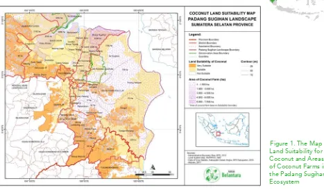
1. The Padang Sugihan Ecosystem (Very Suitable for Coconut Plantations)
Figure 1. The Map of Land Suitability for Coconut and Areas of Coconut Farms in the Padang Sugihan Ecosystem
Map Analysis:
Refer to Figure 1. The Map of Land Suitability for Coconut and Areas of Coconut Farms in the Padang Sugihan Ecosystem.Coconut plants in the Padang Sugihan Ecosystem grow and develop in the transmigration community, a transmigration community that was formed from the transmigration program during President Soeharto era. In addition to relying on
fishponds and fishing for their livelihood, the coastal population of South Sumatra also has a coconut center, which
the people rely on economically. In 2016, the copras in this Ecosystem yielded a production of 5,387.68 tons and contributed to 12.25 percent of Banyuasin Regency’s copra production (BPS Banyuasin, 2017).
The Social-Economic Profile of the Padang Sugihan Ecosystem: The majority of the population in the Padang Sugihan
Ecosystem are high school educated. 39.86% of its population is over five years old. The number of people with higher
education is less than 1%.
There are about 293,700 of productive aged people who mostly work in the agricultural sector of rice and companion
such as the Cengal district, Sungai Menang district, Tulung Selapan district, Muara Sugihan Sub-district, and the Banyuasin I Sub-district. The rubber commodity remains the mainstay in the plantation sector of the Padang Sugihan Ecosystem, both in the OKI Sub-district and Banyuasin Sub-district. There are also small parts of areas that are planted with palms, coconuts, cacaos, and coffees (Belantara, 2017).
Conclusion: The Padang Sugihan Ecosystem has the potential of coconut plantations that are economically valuable, and the community uses it to produce copra. There is an opportunity for a community empowerment program in this Ecosystem. The population in this Ecosystem are mostly from the transmigration program.
The plantation commodities in the Padang Sugihan Ecosystem
Regencies/Cities Cacao Rubber Palm Oil Coconut Coffee Others
Ogan Komering Ilir 396.20 153,237 12,845.00 3,895.00 277.43 4.00
Banyuasin 216.21 71,522.90 26,518.28 24,234.15 470.36 10.10
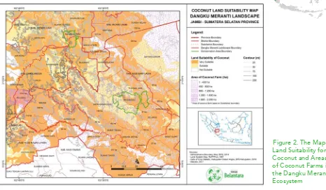
2. Dangku Meranti Ecosystem - (Suitable for Coconut Plantations)
Figure 2. The Map of Land Suitability for Coconut and Areas of Coconut Farms in the Dangku Meranti Ecosystem
Map Analysis: Refer to Figure 2. The Map of Land Suitability for Coconut and Areas of Coconut Farms in the Dangku Meranti Ecosystem.
There are only small remains of coconut plants in the ecosystem of Dangku Meranti because the people in this ecosystem mainly grow rubber, palm and HTI (Industrial Forest Plantations). The high prices of rubber and palm oil in the commodity markets around the Dangku Meranti Ecosystem make coconuts a side commodity, which is only used for the community’s
consumption or sold locally.
The Social-Economic Profile of the Dangku Meranti Ecosystem: The Dangku Meranti Ecosystem spreads across two provinces, Jambi Province and South Sumatra Province. It comprises of one administrative area (Jambi City), three regencies in Jambi Province, and two regencies in South Sumatra Province (Musi Rawas Regency, and Musi Banyuasin Regency). In total, there are 22 sub-districts which are partially or entirely within the boundaries of this ecosystem. 939,363
people populate this ecosystem, with the majority being Muslims.
have graduated from primary school, 17.53% have graduated middle school, and 17.20% have graduated high
school.
The types of crops cultivated by the smallholder farmers are rubber, palm oil, cacao, coconut, and coffee. There are 520,313.14 hectares of rubber smallholders, and 203,874.90 hectares of palm oil smallholders. Cacao crops
are dominant in Muaro Jambi Regency, while coconut crops are dominant in Musi Banyuasin Regency. Coffee
is grown in Musi Rawas Regency and covers an area of 2,296.28 hectares (Belantara, 2017).
Conclusion: Coconut plantations in the Dangku Meranti Ecosystem are only community traditional plantations.
The people of Dangku Meranti prefer rubber and palm oil commodities as their preeminent commodities.
The plantation commodies in the Dangku Meranti Ecosystem
Regency/city
Smallholder Farmers Plantation Area (hectare)
Gambir
Cacao
Rubber
Palm Oil
Coconut
Coffee
Areca nut
Musi Rawas
-
408.81
170,253.69
26,753.84
206.56
2,296.28
2.66
Musi Banyuasin
108,25
295.59
145,655.74
60,829.44
3,128.60
21.53
4.44
Sarolangun
-
104.60
84,716.85
17,301.61
50.90
15.67
3.07
Batang Hari
-
100.36
68,657.74
35,187.74
143.53
5.48
13.51
Muaro Jambi
-
1,821.72
48,658.52
56,070.80
542.43
6.87
93.41
Kota Jambi
-
95.47
2,370.59
7,731.47
461.69
6.50
79.08
Total
108,25
2,826.55
520,313.14
203,874.90
4,533.70
2,352.33
196.17
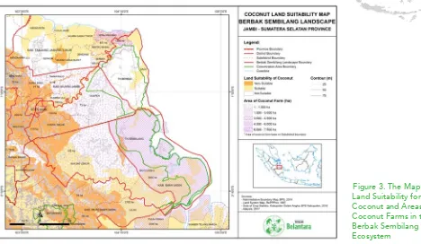
3. Berbak Sembilang Ecosystem – (Suitable for a Coconut Plantations)
Figure 3. The Map of Land Suitability for Coconut and Areas of Coconut Farms in the Berbak Sembilang Ecosystem
Map Analysis: Refer to Figure 3. The Map of Land Suitability for Coconut and Areas of Coconut Farms in the Berbak Sembilang Ecosystem.
The status of coconuts in the ecosystem of Berbak Sembilang has made South Sumatra Province’s coconut trading center to be located in Banyuasin Regency, in its four sub-districts namely Rimau Island Sub-district, Muara Telang Sub-district, Tanjung Lago Sub-district and Banyuasin 2 Sub-district/Muara Sungsang. The coconut area in these four sub-districts reaches 47,285 hectares with a total production of 44,269 tons of coconut (RMOL, 2016).
The high economic value of coconut, especially in Banyuasin 2 Sub-district is because of the coconut export demand to China and Japan. With an area of 2187 hectares, each year the Banyuasin 2 Sub-district produces 65 million coconut seeds with a production capacity of 5000 grains per hectare per month (Mongabay, 2017). Coconut plants in this ecosystem require replanting, intensification programs, and income diversification and empowerment programs.
population that has not complete primary school is 20.56%, 31.59% graduated primary school, 16.71% graduated middle school, 18.93% graduated high school, less than 5% achieved higher education. Of the 272,208 working aged people, 29.10% works in the plantation sector, 16.88% works cultivating rice and companion crops, 4.10% works in the fisheries sector, 16.25% works in the trade sector, 8.57% works in the public service sector, 5.76 works in construction, 4.08% in transportation and warehousing, 3.67% works in
education, and 3.05% works in the processing industry.
The prominent plantations in the Berback Sembilang Ecosystem are coconuts, rubber, and palm oils. Transmigrants, utilizing two hectares of land granted by the government initially planted coconuts; by time,
with palm oil and rubber companies coming in, and with the development of their plantations, coconut plants
were later replaced by palm oil and rubber (Belantara, 2017).
Conclusion: The Berbak Sembilang Ecosystem has the potential of export-worthy coconut plantations and an opportunity for community empowerment programs. Residents in this ecosystem come from Java Island, Lampung Province, and migrants from Riau Province.
Plantation commodity in the Berbak Sembilang Ecosystem
Plantation
Crops
Plantation areas by farming household (hectare)
Total area (ha) Muaro Jambi East Tanjung Jabung Jambi City Musi Banyuasin Banyuasin
Rubber 48,658.52 104.24 2,370.59 145,655.74 71,522.90 276,312.00
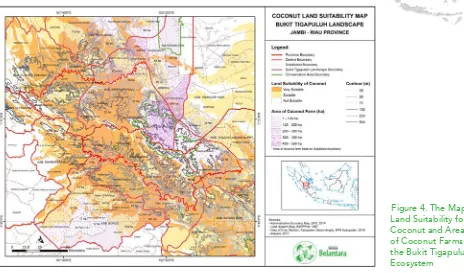
4. Bukit Tigapuluh Ecosystem – (Very Suitable for Coconut Plantations)
Figure 4. The Map of Land Suitability for Coconut and Areas of Coconut Farms in the Bukit Tigapuluh Ecosystem
Map Analysis: Refer to the Figure 4. The Map of Land Suitability for Coconut and Areas of Coconut Farms in the Bukit Tigapuluh Ecosystem.
Coconuts in the Bukit Tiga Puluh Ecosystem, mainly in Indragiri Hilir Regency, is the center of coconut trade in Riau Province. Indragiri Hilir has 11.46% of the nationals coconut plantations from a total of 3,742,921 hectares of smallholder coconut plantations nationally (data from Directorate General of Estate Crops Year 2012). Indragiri Hilir Regency, unofficially called Inhil is the most significant producer of coconuts in Indonesia and the World. Geographically, Indragiri Hilir Regency is mostly dominated by swamp, 10,740.16 km2 (92.54%) and some highland, which is only 865,81 km2 (7,46%) of its area. This geographical condition makes Indragiri HIlir Regency a highly potential area to grow coconuts (Cocos nucifera). It is evidenced by the broad areas of coconut plantations in Indragiri Hilir Regency that mostly belong to the smallholders;
only a small proportion of the coconut plantations are company owned, 429,110 hectares, with 391,745 hectares of it
being Cocos nucifera and 37,365 hectares being hybrid coconuts (Disbun, 2016).
the population graduated middle school, and 15% of them graduated Highschool. There are only about 2.1%
bachelors or postgraduates.
There are about 303,170 of productive aged people. The majority of them work in plantations (62.37% or 189,102 people), which far exceeds other sectors, such as trade (11.31%), community services (6.66%), and education (4.82%). The percentage of those working in agriculture (rice or companion crops) is tiny, 5.22% (15,204). The significant amount of workers in the plantation sector shows that this sector can absorb labor,
especially smallholder farmers.
Based on the Agricultural Census of 2013 it is seen that the smallholder farmers in and around the landscape
rely on three primary commodities, which are rubber, palm oil and coconut (Belantara, 2017).
Conclusion: The Bukit Tiga Puluh Ecosystem, which is located in the two provinces of Jambi Province and
Riau Province is a vibrant ecosystem of fauna. The coconut plantations in Riau Province are the main coconut
plantations in Indonesia and has distributed its coconut products to markets throughout Indonesia by companies that invest in Indragiri Hilir Regency. Community development and empowerment can be in the
form of changing its society’s outlook on business diversification when coconut prices decrease; livelihoods
programs on health and welfare can also improve the community’s nutrition and healthy living habits.
.
Plantation Commodities in the Bukit Tigapuluh Ecosystem
Regency/City
Plantation Areas (hectares)
Clove Cacao Rubber Palm Oil Coconut Coffee Pepper Areca nut Sago Others
Kuantan Singingi 7.01 149.26 47,925.25 36,469.14 288 10.15 0.05 8.62 0.13 0
Indragiri Hulu 0.26 533.94 46,810.77 79,434.38 262.05 14.94 0.01 182.84 0 0.5
Indragiri Hilir 5.3 93.1 3,939.32 61,178.64 210,107.10 468.58 0.17 10,055.61 1,108.03 13.89
Tanjung Jabung Barat 0 77.22 9,754.04 54,711.50 35.587.47 3,792.77 3.18 16,712.97 0 0
Tebo 0.77 317.52 109,203,.3 28,019.47 189.31 27.17 0.16 7.16 0 0
Bungo 6.27 214.69 78,753.80 34,655.78 134.2 489.63 0 10.49 0 0
Total areas (Ha) 19.61 1,385.74 296,386.90 294,468.91 246,568.14 4,803.25 3.57 26,977.69 1,108.15 14.39
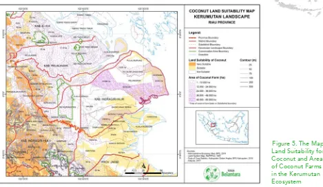
5. Kerumutan Ecosystem – (Very Suitable for Coconut Plantations)
Figure 5. The Map of Land Suitability for Coconut and Areas of Coconut Farms in the Kerumutan Ecosystem
Map Analysis: Refer to Figure 5. The Map of Land Suitability for Coconut and Areas of Coconut Farms in the Kerumu-tan Ecosystem.
The Kerumutan Ecosystem is located in the Indragiri Hilir Regency and shares parts of Indragiri Hilir Regency with the Bukit Tiga Puluh Ecosystem. As is the Bukit Tiga Puluh Ecosystem, the Kerumutan Ecosystem is also the main center of coconut products. The area of coconut plantations around the Kerumutan Ecosystem is more extensive compared to the Bukit Tiga Puluh Ecosystem. Areas around the Kerumutan Ecosystem, particularly in the Kateman Sub-district of Indragiri Hilir
Regency is the center of coconut production in Indonesia. At the site stands the largest coconut company in Indonesia, which produces a variety of processed coconut products.
Communities in this location have difficulties concerning the sustainability for coconut production in their plantations. The challenges that threaten it are the coconut beetle pests that attack the coconut leaf buds. There is also the problem of
The Social-Economic Profile of the Kerumutan Ecosystem: The majority of the population are Muslims, while the ethnicity includes Malay, Javanese, Minang, and some Sulawesi tribes. There are two indigenous minorities in this Ecosystem, namely the Petalangan Tribe and the Duanu Tribe. There are also 29 “Pebatinan” and “Kepenghuluan” in this Ecosystem, which originated from the Pelalawan Kingdom.
The population of productive aged people in the Kerumutan Ecosystem is about 323,924 people, with the majority working in plantations (45.30%); the rest work in the trade sector (11.27%), community services
(9.22%), and rice and companion crops (9.09%). Besides those, the percentage of workers in other sectors is
not very prominent, the processing industry (5.55%), construction (3.39%), fishery (2.04%), and forestry (1.04%).
The majority of people aged five years and over have completed primary school (33.91%), although 21.93% have not or did not finish primary school. More than half of the Kerumutan Ecosystem educational level is primary education. Those who have graduated middle school or it’s equivalent is as much as 17.16 %; high school/equivalent graduates are 16.22%.
Based on the dedicated land area and the type of plant, plantation commodities are the mainstay of the
population in the Kerumutan Ecosystem, especially palm oils, with a land area of 546,094 hectares, and coconuts with the land area of 461,031 hectares. The most massive coconut plantation is located in Indragiri
Hilir Regency, whereas many palm oils are grown in Indragiri Hilir Regency and Pelalawan Regency (Belantara,
2017).
Conclusion: Coconut plantations in the Kerumutan Ecosystem, which is the largest coconut plantation site in Indonesia require several mentoring programs. The coconut beetle pest (Oryctes rhinoceros L.) problem requires IPM (Integrated Pest Management) treatment, which can be socialized to the community. A replanting program for the community’s aging coconut plantation can also be one of the leading programs that can be done.
Plantation Commodities in the Kerumutan Ecosystem
Regency/City
Plantation areas and type of crops (hectares)
Rubber
Coconut
Palm Oil
Coffee
Areca nut
Indragiri Hulu
61,372
1,828
11,897
348
383
Indragiri Hilir
5,369
442,335
228,052
1,237
16,384
Pelalawan
29,074
16,868
306,145
1,289
53
Total
95,815
461,031
546,094
2,874
16,820
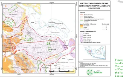
6. Kampar Peninsula Ecosystem – (Suitable for Coconut Plantations)
Figure 6. The Map of Land Suitability for Coconut and Areas of Coconut Farms in the Kampar Peninsula Ecosystem
Map Analysis: Refer to Figure 6. The Map of Land Suitability for Coconut and Areas of Coconut Farms in the Kampar Peninsula Ecosystem.
The coconut plantations in the Kampar Peninsula Ecosystem are located around the Pelalawan Regency. Small amounts of land in this ecosystem are used for coconut plantations. Coconut plantations in Pelalawan Regency are located in five sub-districts, namely Langgam district, Sikijang district, Pangkalan Kerinci district, Pangkalan Kuras
Sub-district, and Pangkalan Lesung. In this ecosystem, the developing palm oil plantations are the community’s primary source of income.
The Langgam Sub-District has 71 hectares of land that is used for coconut plantation, with a coconut production of around 98 tons. Land areas used for coconut plantations in Sikijang Sub-district is about 7.2 hectares, with a production capacity of approximately 7.3 tons per year. The Pangkalan Kerinci Sub-district has a coconut plantation area of about 24.5 hectares, with a production capacity of 24 tons per year. The land area that is used for coconut plantation in Pangkalan Kuras Sub-district is 16.48 hectares, with a total production of around 30.822 tons per year. Coconut plantations areas in the subdistrict of Pangkalan amount to 38 hectares and yields a total production of about 38 tons of coconuts per year
The Social-Economic Profile of the Kampar Peninsula Ecosystem: About 85.69% of Kampar Peninsula Ecosystem’s population are Muslims, while Protestants make up for around 11.7% of the population. The rest are Catholics, Hindus, Buddhists, and Confucians. The majority of people in this Ecosystem aged 15 years old and above have completed primary school (27.44%), although a lot of them have not (21.12%). The percentage of middle school graduates is 21.08%, while high school graduates are 18.06%. Only 6% have a higher education.
The number of productive workers in the Kampar Peninsula Ecosystem’s is about 93,472 people. Most of them work in the plantation sub-sector (37.28%), the trade sector (12.28%) and social services (11.33%). There are about 7.8% employed in manufacturing, 5.49% in construction, and 5.31% in the education sector.
Population groups who work in the agricultural sector (rice and companion crops) only amount to 4.13%. The plantation sub-sector is the pillar of most people within the Kampar Peninsula ecosystem. Outside the number of people working in plantation companies, the 2013 Agricultural Census (Central Bureau of Statistics of Riau,
2014) show that at the smallholders level, palm oil has become the most widely planted commodity on their
lands. The area of land planted with palm oil reached 171,191.86 hectares, which amounts to five times the area of land planted with rubber, about 34,102.14 hectares (Belantara, 2017).
Conclusion: The type of plantation that dominates in this ecosystem are palm oil plantations. The plantation
sub-sector, especially palm oil, is the community’s primary source of income. Currently, only small amounts of
land are used for coconut plantations, and it competes with the already prevalent palm oil plantations. The
relatively small amount of coconut plantations in this ecosystem would make coconut-based development
programs inefficient. The development programs should be allocated to other commodity products that are
already cultivated by the community.
Plantation commodity in the Kampar Peninsula Ecosystem
Regency
Plantation/cultivation Areas (hectares) by smallholders
Cacao Rubber Oil palm Coconut Candlenut Coffee Areca nut Sago
Pelalawan
31.68
24,993.90
76,837.62
9,481.36
21.47
60.35
96.12
521.20
Siak
77.04
9,108.24
94,361.24
1,655.95
0.00
12.75
42.45
264.08
Total (Ha)
108.72
34,102.14
171,198.86
11,137.31
21.47
73.09
138.57
785.28
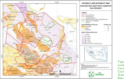
7. Giam Siak Kecil Bukit Batu Ecosystem – (Not Suitable for
Coconut Plantations)
Map Analysis: Refer to Figure 7. The Map of Land Suitability for Coconut and Areas of Coconut Farms in the Giam Siak Kecil Bukit Batu Ecosystem.
Giam Siak Kecil Bukit Batu Ecosystem is largely occupied by palm oil plantations, both by companies and communities. Only small areas of coconut plantations are still left in this area and are used only as a source of fresh coconut for sale in
the city or for their own consumption.
The Social-Economic Profile of the Giam Siak Kecil Bukit Batu Ecosystem: The Giam Siak Kecil-Bukit Batu (GSKBB) Ecosystem is adjacent to the Senepis Ecosystem and Kampar Ecosystem, in fact, there are two regencies/cities in the Senepis Ecosystem that are part of the GSKBB Ecosystem.
The majority of the population are Muslims with native Malay culture. The transmigrants from Java Island, Kalimantan Island, Sulawesi Island and the Riau’s surrounding areas make up for the diverse ethnic population of the GSKBB Ecosystem.
Based on the level of education, people aged five years and over have had a high school education or equivalent. From about 438,030 people, the percentage of people aged 15 years and above: 26.02% work in the plantation sector, 17.23% work in trade, 12.51% in community service, 7.66% in construction and 7.14% work in the manufacturing industry. People who work in agriculture, livestock, or fishery is only about 1-3% of
the total workforce.
The 2013 Agriculture Census shows that the largest amount of planted commodities are palm oil, rubber, and
coconut; a contrast from areas planted with crops such as rice, companion crops, and horticulture crops. In
the same year, the total of rice fields in the GSKBB Ecosystem only amounts to 37,601 hectares of rice fields and agricultural fields. While, the total area planted with maize and cassava is only about 15,611 hectares (Belantara, 2017).
Conclusion: There are only small areas of coconut plantations left that are still being planted in the Giam Siak
Kecil Bukit Batu Ecosystem. The remaining coconut plantations are utilized only to be sold in the city or to be
consumed by the community itself.
Plantation commodities in the GSKBB Ecosystem
Regency/City
Plantation Areas (Ha)
Rubber Coconut Palm Oil Areca Coffee Cacao
Siak 16,129 1,657 287,782 259 140 66
Kampar 101,966 1,806 387,263 99 17 286
Bengkalis 3,786 12,684 198,642 1,005 343
-Rokan Hilir 2,639 5,469 273,145 117 20 260
Pekanbaru 2,926 6 10,745 - - 13
Dumai 2,355 1,929 36,345 103 29 26
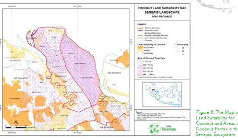
8. Senepis Ecosystem – (Not Suitable for Coconut Plantations)
Map Analysis: Refer to Figure 8. The Map of Land Suitability for Coconut and Areas of Coconut Farms in the Senepis Ecosystem.
The coconut plantations in the Senepis Ecosystem are not too extensive and many are on peatlands. In addition, most areas have changed their commodities with palm oil plantations, and HTI (Industrial Forest Plantation). The Senepis
ecosystem has become a serious concern for the development of the region and its growing commodities, starting from
the established canals, tenurial conflicts, animal conflicts with plantations to the conflicts of the peat areas.
The Social-Economic Profile of the Senepis Ecosystem: The total population of all the sub-districts in the Senepis Ecosystem is 371,701. The largest population is Dumai Barat Sub-district (89,978 inhabitants), and the least populated area is Batu Hampar Sub-district (7,213 inhabitants).
The majority of the population are Muslims, while the ethnicity is quite diverse. The natives of the Senepis Ecosystem are Malay. Tribes that have inhabited this region for years are the Minang tribe, Javanese, Bugis, and Chinese. The economic development of Rokan Hilir Regency and Dumai City has encouraged the entry of migrant communities to work in various
business sectors.
The majority (106,768) of the population have graduated primary school or its equivalent. People of over 15 years old and working is 126,889. They mostly work in the plantation sector (32.58%), growing rice crops and companion crops (12.91%), trade (12.88%) and community services (13.91%). The percentage of the people working in forestry, fishery, and mining as a whole is around 6.1%.
By comparison, more areas are planted with plantation crops than agricultural crops, such as rice or horticulture. Palm oil is the most popular commodity and has more plantation areas compared to rubber, coconut or cacao
in the Senepis Ecosystem (Belantara, 2017).
Conclusion: Coconut plantations in the Senepis Ecosystem are less developed compared to other regions in Riau Province. Plantation concessions that flourish in this ecosystem are more abundant in palm oil and HTI
(Industrial Forest Plantations) commodities.
Plantation commodities in Senepis Ecosystem
Type of crops
Plantation areas (ha)
Rokan Hilir Regency Dumai City Total
Farming
Wet rice field 12,271 244 12,515
Dry rice field 14 194 208
Corn 510 41 551
Cassava 316 223 539
Plantation
Rubber 2,926 2355 5,281
Coconut 5,469 1,929 7,398
Palm Oil 273,145 36,345 309,490
Cacao 260 26 286
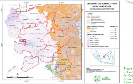
9. Kubu Raya Ecosystem – (Suitable for Coconut Plantations)
Map Analysis: Refer to Figure 9. The Map of Land Suitability for Coconut and Areas of Coconut Farms in the Kubu Raya Ecosystem.
Kubu Raya is known as one of the coconut centers in West Kalimantan. Based on 2010’s data, there are 36,117 hectares of land used for of coconut plantations, with 34,395 tons of coconut production per year (Tribun, 2012).
Coconut plantations in the Kubu Raya Ecosystem have similar problems with coconut plantations in Riau Province, which is the threat of the coconut beetle attack against a coconut plant’s shoots and roots. The imago of the coconut beetle (Oryctes sp.) eats the young leaves of the coconut plant that are still buds, which make the leaves to form like a fan when it blooms. This pest attack causes the disturbance of the photosynthesis process, thus reducing the production. With an
underdeveloped coconut industry in this area compared to Riau Province, combined with the price of coconut that is less attractive for farmers to sell in Pontianak City, farmers who want a reasonable price for their products eventually sell to areas such as Riau Province, Java Island and Malaysia.
The Social-Economic Profile of the Kubu Raya Ecosystem The population in the Kubu Raya Ecosystem is 285,920
people or about 6.5% of the total population of West Kalimantan, which is 4,395,983.
According to the Indonesia Central Bureau of Statistics’s 2014 data of West Kalimantan, about 46.5% of the Kubu Raya Ecosystem’s population work in the plantation sector, a majority compared to other industries. Even so, there are also many of who work in the agricultural sector of rice and companion crops. The percentage of
the people who work in construction, transportation, forestry, and mining sectors is below 10%. Besides those,
the sectors of finance, transportation, electricity and gas, education services, and social services constitute 8.7% of the population’s work sector.
Based on the educational level, the average people in the Kubu Raya Ecosystem have a basic level of
education. In essence, there are those who have or are in the process of completing primary school (32%) and
those who have completed primary school (30%). Middle school/equivalent graduates are 11%, while High School/equivalent is about 7%. The percentage of people with higher education (diploma, undergraduate,
postgraduate) are still below 2%.
Based on the type of crops grown, rubber and palm oil are the most cultivated commodity by smallholder
farmers. Based on the 2013 Agricultural Census of 2013 (West Kalimantan Central Bureau of Statistic, 2014), the amount of land planted with rubber reached 254,096.97 hectares, while the total land areas planted with palm oil reached 101,090.45 hectares. The types of crops grown by the people in Sanggau Regency are mostly palm oil and rubber, while in Kubu and North Kayong, it is rubber, coconut, and coffee. (Belantara, 2017).
Conclusion: The Kubu Raya Ecosystem, which is known as one of the coconut centers in West Kalimantan, is facing a challenge of productivity. The threat of pest attacks and low prices of coconut products and copra
becomes a challenge in the coconut development program.
Plantation commodities in Kubu Raya Ecosystem
Regencies
Plantation areas /cultivation (ha)
Clove Cacao Rubber Palm Oil Coconut Coffee Pepper Areca Sago
North Kayong 11.74 4.63 8,218.00 252.21 3,382.50 1,020.94 22.43 6.26 -
Kubu Raya 52.31 62.50 30,392.37 3,999.41 23,209.28 4,053.33 223.10 592.04 296.97
Sanggau 48.65 951.43 121,213.67 67,400.43 670.73 10.42 1,168.20 0.02 1.44
Ketapang 3.50 94.02 94,272.93 29,438.39 1,278.97 372.00 4.79 0.98 0.34
Total (ha) 116.19 1,112.58 254,096.97 101,090.45 28,541.49 5,456.69 1,418.51 599.30 298.75
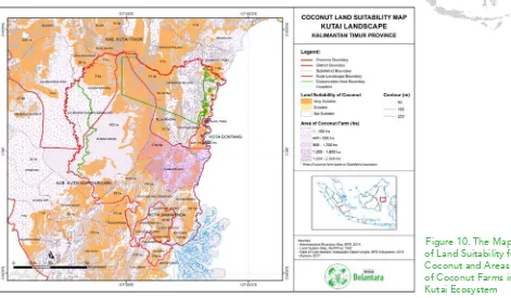
10. Kutai Ecosystem – (Suitable for Coconut Plantations)
Map Analysis: Refer to Figure 10. The Map of Land Suitability for Coconut and Areas of Coconut Farms in the Kutai Ecosystem.
Not much can be told about coconut plantations in the Kutai Ecosystem. In this ecosystem, the coconut plantations have been planted in polyculture and is not a major commodity crop. The entry of prime plantation commodities such as
palm oil and rubber plantations has caused the community to switch their major commodities into palm oil and rubber. Communities also began developing horticultural estates around their home yards as a differentiation of agricultural
income. In addition, the mining sector in East Kalimantan Province grows jobs that promise better livelihoods than the
plantation sector.
The Social-Economic Profile of the Kutai Ecosystem The population of the sub-districts within the Kutai Ecosystem is 1,287,853 people and are predominantly Muslim (91.35%). The highest population density is in Samarinda Seberang Sub-district (9,142 inhabitants/km2), while the lowest population density is in Muara Ancalong Sub-district, which is 4.6 people/km2.
Based on ethnicity, people in the Kutai Ecosystem come from the native ethnicities in the region, i.e., Kutai and some
Dayak sub-ethnic groups, such as the Kenyah. However, many residents are also of Bugis and Javanese tribes, which came from transmigration programs since the 1970s.
Based on a person’s last level of education, the percentage of the population aged five years and over who has graduated high school/equivalent is 29.1%, those with only primary school/equivalent education is 22.9%, middle school/equivalent is 18.2%, and those who did or have not finished primary school amounts to 17.8%.
While the percentage of people with bachelor degrees or higher is higher than people with I-III diplomas.
There are approximately 561,082 productive-aged people in this Ecosystem. The majority work in trading (17.6%), community services (12.6%), mining and quarrying (10.1%), construction (7.4%), and rice cultivation and companion crops (7.1%). Approximately 8.9% of workers work in the hospitality and restaurants, financial
services and insurance, and educational services. In contrast to other Ecosystems, the plantation business in
the Kutai landscape is low (3.6%). Based on the 2013 Agricultural Census, the area of plantation cultivated by smallholder farmers in the regencies/cities in the Kutai Ecosystem is not much, including the East Kutai Regency and Kutai Kartanegara Regency where most of the people work in agriculture and plantation sectors. Rubber and palm oils as a whole have the largest planting area in this Ecosystem, rubber reaching 38,942 hectares and palm oil reaching 38,938 hectares. Even so, the total area is far above the areas of land planted with coconut, cacao or pepper (Belantara, 2017).
Conclusion: The development of coconut plantations in the Kutai Ecosystem has been greatly undermined by
the leading commodities of rubber and palms oils. In addition, the mining sector dominates the non-plantation
commodities of East Kalimantan Province.
Plantation commodities in Kutai Ecosystem
Regencies/cities
Plantation areas and type of crops managed/cultivated by smallholders
Sugar Palm Clove Cacao Rubber Palm Oil Coconut Candlenut Coffee Pepper Others
Kutai Kartanegara 42 28 1,000 26,167 18,849 2,884 48 172 1,423 6
East Kutai 34 27 2,746 10,472 17,111 1,031 259 172 303 5
Samarinda 22 0 47 1,715 1,833 113 296 46 31 4
Bontang 9 1 53 589 1,145 175 35 27 9 3
COST FOR A COCONUT
PLANTATION PER YEAR
The Cost Estimate of Commodity Development Programs
1. Farmer awareness for GAP (Good Agricultural Practices), US $ 120 per person per
year.
2. Construction of an urban farming demonstration plot for the differentiation of
agricultural products, US $ 80 per person per year
3. Integrated Farming Program (farming and fishery), US $ 650 per person per year.
4. A suppot program for coconut downstream and product processing machineries,
US $ 14,700 per site (or the support of selecting agricultural processing machines).
5. Management program US $ 1,700 per month
REFERENCES
Anonim. 2016. Kelapa Inhil Pusaka Riau http://disbun.inhilkab.go. id/kelapa-inhil-pusaka-riau. Diakses 01 Januari 2018 20.21
Anonim. 2017. Indonesia, Negara Produsen Kelapa Terbesar di Dunia. https://databoks.katadata. co.id /datapublish /2017/01/06/ indonesia-negara-produsen-kelapa-terbesar-di-dunia. Diakses 31-01-18, 16:43
Belantara, Yayasan.2017.Panduan Yayasan Belantara: Rencana Pengembangan Konservasi di Area Hibah Target di Sumatera dan Kalimantan. Yayasan Belantara. Jakarta Pusat.
BPS.2002-2017. Jambi dalam angka 2002-2017.Badan Pusat Statistik.Jambi
BPS.2002-2017. Sumatra Selatan dalam angka 2002-2017.Badan Pusat Statistik.Sumsel BPS.2009-2017.Kalimantan Timur dalam angka 2009-2017.Badan Pusat Statistik.Kaltim BPS.2008-2016. Kalimantan Barat dalam angka 2008-2016.Badan Pusat Statistik.Kalbar BPS.2008-2015.Riau dalam angka 2008-2015.Badan Pusat Statistik.Riau
Kementrian Pertanian. Dirjen Perkebunan.2016.Buku Statistik Perkebunan Indonesia: Kelapa 2015-2017. Kementan.Jakarta
Pemkab Pelalawan.2009.Laporan Akhir Kajian Iventarisasi Potensi Sumber Daya Alam di Kabupaten Pelalawan Tahun 2009.Pemkab Pelalawan.Riau
Okta, Erik.2016. 4 Kecamatan di Banyuasin dijadikan lumbung kelapa sumsel. http://www. rmolsumsel.com/read/2016/06/04/51979/4-Kecamatan-di-Banyuasin-Dijadikan-Lumbung-Kelapa-Sumsel-. Diakses tanggal 30 desember 2017 23.56
Wijaya, Taufik.2017. Harapan Warga Muara Sungsang: Kawasan Ekonomi Khusus Tanjung Api-Api Tidak Gusur Kebun Kelapa (Bagian 2). http://www.mongabay.co.id/2017/02/03/
harapan-warga-muara-sungsang-kawasan-ekonomi-khusus-tanjung-api-api-tidak-gusur-kebun-kelapa-bagian-2. Diakses tanggal 30 Desember 2017 23.21 Warisno.2003. Budidaya Kelapa Genjah. Penerbit Kanisius.Yogyakarta.