Approval Date: 2015-11-06
Publication Date: 2016-04-27
External identifier of this OGC® document: http://www.opengis.net/doc/PER/GW2IE
Internal reference number of this OGC® document: 15-082
Category: OGC® Engineering Report
Editor: Boyan Brodaric
OGC GroundWaterML 2 – GW2IE FINAL REPORT
Copyright notice
Copyright © 2016 Open Geospatial Consortium
To obtain additional rights of use, visit http://www.opengeospatial.org/legal/.
Warning
This document is not an OGC Standard. This document presents a discussion of
technology issues considered in an initiative of the OGC Interoperability Program. This document does not represent an official position of the OGC. It is subject to change without notice and may not be referred to as an OGC Standard. However, the discussions in this document could very well lead to the definition of an OGC Standard. Recipients of this document are invited to submit, with their comments, notification of any relevant patent rights of which they are aware and to provide supporting documentation.
Document type: OGC® Public Engineering Report Document subtype: NA
License Agreement
Permission is hereby granted by the Open Geospatial Consortium, ("Licensor"), free of charge and subject to the terms set forth below, to any person obtaining a copy of this Intellectual Property and any associated documentation, to deal in the Intellectual Property without restriction (except as set forth below), including without limitation the rights to implement, use, copy, modify, merge, publish, distribute, and/or sublicense copies of the Intellectual Property, and to permit persons to whom the Intellectual Property is furnished to do so, provided that all copyright notices on the intellectual property are retained intact and that each person to whom the Intellectual Property is furnished agrees to the terms of this Agreement.
If you modify the Intellectual Property, all copies of the modified Intellectual Property must include, in addition to the above copyright notice, a notice that the Intellectual Property includes modifications that have not been approved or adopted by LICENSOR.
THIS LICENSE IS A COPYRIGHT LICENSE ONLY, AND DOES NOT CONVEY ANY RIGHTS UNDER ANY PATENTS THAT MAY BE IN FORCE ANYWHERE IN THE WORLD.
THE INTELLECTUAL PROPERTY IS PROVIDED "AS IS", WITHOUT WARRANTY OF ANY KIND, EXPRESS OR IMPLIED, INCLUDING BUT NOT LIMITED TO THE WARRANTIES OF MERCHANTABILITY, FITNESS FOR A PARTICULAR PURPOSE, AND NONINFRINGEMENT OF THIRD PARTY RIGHTS. THE COPYRIGHT HOLDER OR HOLDERS INCLUDED IN THIS NOTICE DO NOT WARRANT THAT THE FUNCTIONS CONTAINED IN THE INTELLECTUAL PROPERTY WILL MEET YOUR REQUIREMENTS OR THAT THE OPERATION OF THE INTELLECTUAL PROPERTY WILL BE
UNINTERRUPTED OR ERROR FREE. ANY USE OF THE INTELLECTUAL PROPERTY SHALL BE MADE ENTIRELY AT THE USER’S OWN RISK. IN NO EVENT SHALL THE COPYRIGHT HOLDER OR ANY CONTRIBUTOR OF
INTELLECTUAL PROPERTY RIGHTS TO THE INTELLECTUAL PROPERTY BE LIABLE FOR ANY CLAIM, OR ANY DIRECT, SPECIAL, INDIRECT OR CONSEQUENTIAL DAMAGES, OR ANY DAMAGES WHATSOEVER RESULTING FROM ANY ALLEGED INFRINGEMENT OR ANY LOSS OF USE, DATA OR PROFITS, WHETHER IN AN ACTION OF CONTRACT, NEGLIGENCE OR UNDER ANY OTHER LEGAL THEORY, ARISING OUT OF OR IN CONNECTION WITH THE IMPLEMENTATION, USE, COMMERCIALIZATION OR PERFORMANCE OF THIS INTELLECTUAL PROPERTY.
This license is effective until terminated. You may terminate it at any time by destroying the Intellectual Property together with all copies in any form. The license will also terminate if you fail to comply with any term or condition of this Agreement. Except as provided in the following sentence, no such termination of this license shall require the termination of any third party end-user sublicense to the Intellectual Property which is in force as of the date of notice of such termination. In addition, should the Intellectual Property, or the operation of the Intellectual Property, infringe, or in LICENSOR’s sole opinion be likely to infringe, any patent, copyright, trademark or other right of a third party, you agree that LICENSOR, in its sole discretion, may terminate this license without any compensation or liability to you, your licensees or any other party. You agree upon termination of any kind to destroy or cause to be destroyed the Intellectual Property together with all copies in any form, whether held by you or by any third party.
1. Scope ... 12
1.1 Motivation ... 13
1.2 Historical background ... 13
2. Conformance ... 14
2.1 XML implementation ... 14
2.2 Use of vocabularies ... 14
2.3 Groundwater data ... 15
3. References ... 15
4. Terms and Definitions ... 16
5. Conventions ... 19
5.1 Requirements class ... 19
5.2 Requirement ... 20
5.3 Conformance class ... 20
5.4 Identifiers ... 21
5.5 External package abbreviations ... 21
5.6 Abbreviated terms ... 22
5.7 UML notation ... 23
5.8 Finding requirements and recommendations ... 23
6. Background ... 24
6.1 Technical Basis ... 24
6.2 Overview of Observations & Measurements ... 24
6.3 Sampling features ... 24
6.4 Overview of GeoSciML 3.2 ... 25
7.1 Hydrogeological Units ... 26
7.2 Fluid Bodies ... 27
7.3 Voids ... 27
7.4 Flow ... 27
7.5 Wells ... 27
7.6 Conceptual Model Specification ... 28
7.6.1 DocumentCitation ... 33
7.6.2 Elevation ... 33
7.6.3 GL_EarthMaterial ... 33
7.6.4 GL_GeologicUnit ... 34
7.6.5 GW_Aquifer ... 34
7.6.6 GW_AquiferSystem ... 35
7.6.7 GW_AquiferUnit ... 36
7.6.8 GW_Basin ... 37
7.6.9 GW_BiologicConstituent ... 37
7.6.10 GW_ChemicalConstituent ... 38
7.6.11 GW_ConfiningBed ... 38
7.6.12 GW_Constituent ... 39
7.6.13 GW_ConstituentRelation ... 41
7.6.14 GW_Discharge ... 41
7.6.15 GW_Divide ... 41
7.6.16 GW_Flow ... 42
7.6.17 GW_FlowSystem ... 43
7.6.18 GW_FluidBody ... 44
7.6.21 GW_HydrogeoUnit ... 47
7.6.22 GW_HydrogeoVoid ... 50
7.6.23 GW_InterFlow ... 51
7.6.24 GW_IntraFlow ... 53
7.6.25 GW_Licence ... 53
7.6.26 GW_ManagementArea ... 53
7.6.27 GW_MaterialConstituent ... 56
7.6.28 GW_Mixture ... 56
7.6.29 GW_MonitoringSite ... 56
7.6.30 GW_Porosity ... 57
7.6.31 GW_Recharge ... 57
7.6.32 GW_Spring ... 58
7.6.33 GW_UnitFluidProperty ... 58
7.6.34 GW_UnitProperties ... 59
7.6.35 GW_UnitVoidProperty ... 59
7.6.36 GW_Vulnerability ... 60
7.6.37 GW_WaterBudget ... 60
7.6.38 GW_Well ... 61
7.6.39 GW_Yield ... 62
8. Logical Model ... 63
8.1 Logical Model Specification ... 65
8.1.1 BoreCollar ... 75
8.1.2 Borehole ... 75
8.1.4 CasingComponent ... 77
8.1.5 ConstructionComponent ... 78
8.1.6 Equipment ... 79
8.1.7 Filtration ... 80
8.1.8 FiltrationComponent ... 80
8.1.9 GW_GeologyLog ... 81
8.1.10 GW_GeologyLogCoverage ... 82
8.1.11 LogValue ... 83
8.1.12 Screen ... 83
8.1.13 ScreenComponent ... 84
8.1.14 Sealing ... 85
8.1.15 SealingComponent ... 86
8.1.16 WellConstruction ... 87
9. Requirements Classes (normative) ... 88
9.1 Abstract requirements classes: GWML2 core logical model ... 88
9.1.1 Quantities ... 89
9.1.2 Code lists ... 89
9.1.3 Code lists URI ... 89
9.1.4 Identifier ... 90
9.1.5 Feature ... 90
9.2 Requirement class: GWML2-Main ... 90
9.2.1 Feature of interest for Association classes ... 90
9.3 Requirement class: GWML2-Constituent ... 92
9.4 Requirement class: GWML2-Flow ... 93
9.5.2 Well shape ... 95
9.5.3 Relative position ... 95
9.5.4 Geology Log ... 96
9.5.5 Monitoring Sites ... 97
9.6 Requirement class: GWML2-WellConstruction ... 97
9.6.1 Borehole ... 97
9.6.2 Construction ... 97
9.7 Requirement class: Vertical Well (profile) ... 98
9.8 Requirement Class: GeologyLog (profile) ... 98
9.9 Requirement class: Aquifer test (profile) ... 100
9.9.1 Aquifer Test O&M mapping ... 102
9.9.2 GW_AquiferTest ... 103
9.9.3 SF_SamplingFeature properties ... 103
9.9.4 OM_Observation ... 106
9.9.5 Aquifer test overview ... 108
10. XML Implementation (normative) ... 109
10.1 GWML2-XSD ... 109
10.1.1 Identifier ... 112
10.1.2 By-Reference properties ... 113
10.2 Requirement class: GWML2-Main XML encoding ... 114
10.3 Requirement class: GWML2-Constituent XML encoding ... 116
10.4 Requirement class: GWML2-Flow XML encoding ... 116
10.5 Requirement class: GWML2-Well XML encoding ... 117
10.5.2 Monitoring Sites ... 123
10.6 Requirement class: GWML2-WellConstruction XML encoding ... 123
10.7 Requirement class: GWML2-Well-Vertical XML encoding (profile) ... 125
10.8 Requirement class: GeologicLog XML encoding ... 125
10.9 Requirement class: Aquifer test XML encoding ... 127
A.1 Introduction ... 132
A.2 Conformance classes – UML packages ... 132
A.2.1 Conformance class: GWML 2.0 core logical model (Abstract) ... 132
A.2.2 Conformance class: GWML 2.0 main logical model ... 134
A.2.3 Conformance class: GWML 2.0 constituent logical model ... 135
A.2.4 Conformance class: GWML 2.0 flow logical model ... 135
A.2.5 Conformance class: GWML 2.0 Well logical model ... 135
A.2.6 Conformance class GWML 2.0 Construction logical model ... 138
A.2.7 Conformance class: GWML 2.0 Vertical Well logical model ... 139
A.2.8 Conformance class: GWML 2.0 Geologic logs ... 140
A.2.9 Conformance class : GWML 2.1 Aquifer Test ... 140
A.3 Conformance classes – XML encoding ... 142
A.3.1 Conformance classes: xml-rules ... 142
A.3.2 Conformance classes : GWML2-Main xml encoding ... 144
A.3.3 Conformance classes : GWML2-Constituent xml encoding ... 144
A.3.4 Conformance classes : GWML2-flow xml encoding ... 145
A.3.5 Conformance classes: GWML2-well xml encoding ... 145
A.3.6 Conformance classes : GWML2-construction xml encoding ... 147
A.3.7 Conformance classes: GWML2-vertical well xml encoding ... 148
2. Policy Use Case ... 154
3. Environmental Use Case ... 158
4. Scientific Use Case ... 161
i.
Abstract
This document describes a conceptual model, logical model, and GML/XML encoding rules for the exchange of groundwater data. In addition, this document provides GML/XML encoding examples for guidance.
ii.
Keywords
The following are keywords to be used by search engines and document catalogues.
ogcdoc, OGC document, groundwater, hydrogeology, aquifer, water well, observation, GroundwaterML, GWML2, well construction, UML, GML
iii.
Preface
The primary goal of this document is to capture the semantics, schema, and encoding syntax of key groundwater data, in order to enable information systems to interoperate with such data.
Attention is drawn to the possibility that some of the elements of this document may be the subject of patent rights. The Open Geospatial Consortium shall not be held
responsible for identifying any or all such patent rights.
Recipients of this document are requested to submit, with their comments, notification of any relevant patent claims or other intellectual property rights of which they may be aware that might be infringed by any implementation of the standard set forth in this document, and to provide supporting documentation.
iv.
Submitting organizations
The following organizations submitted this Document to the Open Geospatial Consortium (OGC):
Geological Survey of Canada (GSC), Canada
U.S. Geological Survey (USGS), United States of America
Commonwealth Scientific and Industrial Research Organisation (CSIRO), Australia
Bureau of Meteorology (BOM), Australia
Federation University Australia (FedUni), Australia
Bureau de Recherches Géologiques et Minières (BRGM), France
Geological Surveys of Germany (GSG), Germany
which this document was developed:
Geological Survey of Canada (GSC), Canada
U.S. Geological Survey (USGS), United States of America
Commonwealth Scientific and Industrial Research Organisation (CSIRO), Australia
Federation University Australia (FedUni), Australia
Bureau of Meteorology (BOM), Australia
European Commission, Directorate General – Joint Research Centre (JRC), European Union
Polish Association for Spatial Information
Polish Geological Institute (PGI), Poland
Geological Surveys of Germany (GSG), Germany
Salzburg University (U Salzburg), Austria
Bureau de Recherches Géologiques et Minières (BRGM), France
British Geological Survey (BGS), U.K.
International Groundwater Resources Assessment Centre (IGRAC), UNESCO
v.
Submitters
All questions regarding this submission should be directed to the editor or the submitters:
Name Affiliation
Boyan Brodaric GSC
Eric Boisvert GSC
Jessica Lucido USGS
Bruce Simons CSIRO
Peter Dahlhaus FedUni
Bernhard Wagner GSG
Sylvain Grellet BRGM
vi.
Future Work
Future work involves coordination with ongoing OGC hydrology standards for surface water and time series observations, to demonstrate how these emerging standards can operate together.
1.
Scope
This document is a conceptual and encoding specification for the representation of core groundwater data. GroundWaterML2 is implemented as an application schema of the Geography Markup Language (GML) version 3.2.1, and re-uses entities from other GML application schema, most notably the OGC Observations & Measurements standard and the GeoSciML 3.2.0 standard from the International Union of Geological Sciences (IUGS).
GroundWaterML2.1 (GWML2) is designed to enable a variety of data exchange scenarios. These scenarios are captured by its five motivating use cases, including:
(1) a commercial use-case focused on drilling water wells with knowledge of aquifers;
(2) a policy use case concerned with the management of groundwater resources; (3) an environmental use-case that considers the role of groundwater in natural
eco-systems;
(4) a scientific use-case concerned with modeling groundwater systems; and (5) a technologic use-case concerned with interoperability between diverse
information systems and associated data formats.
GWML2 is designed in three stages, each consisting of a schema that builds on the previous stages. The three schemas include:
(1) Conceptual (UML): a technology-neutral schema denoting the semantics of the
domain;
(2) Logical (UML): a GML-specific schema that incorporates the OGC suite of
standards; and
(3) XML schema (XSD): a GML syntactical encoding of the logical schema.
In addition, this specification describes general and XML-specific encoding requirements, general and XML-specific conformance tests, and XML encoding examples. The specification is designed for future extension into other non-XML encoding syntaxes, which would require each such encoding to describe the related schema, requirements and conformance classes, as well as provide examples.
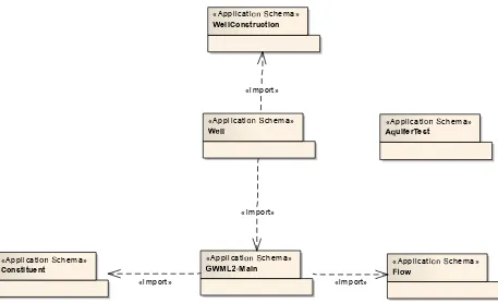
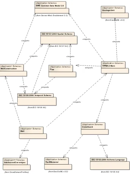
The GroundWaterML2 Logical and XML schemas are organized into 6 modular packages.
body.
(3) GWML2-Flow: groundwater flow within and between containers. (4) GWML2-Well: water wells, springs, and monitoring sites.
(5) GWML2-WellConstruction: the components used to construct a well.
(6) GWML2-AquiferTest: the elements composing an aquifer test (e.g. pumping test).
Altogether, the schemas and packages represent a precise description of the key features associated with the groundwater domain, as well as their properties and relationships. This provides a semantics and syntax for the correct machine interpretation of the data, which promotes proper use of the data in further analysis. Existing systems can use GWML2 to ‘bridge’ between existing schema or systems, allowing consistency of the data to be maintained and enabling interoperability.
1.1 Motivation
A significant portion of the global water supply can be attributed to groundwater
resources. Effective management of such resources requires the collection, management and delivery of related data, but these are impeded by issues related to data availability, distribution, fragmentation, and heterogeneity: collected data are not all readily available and accessible, available data is distributed across many agencies in different sectors, often thematically fragmented, and similar types of data are diversely structured by the various data providers. This situation holds both within and between political entities, such as countries or states, thereby impairing groundwater management across all jurisdictions. Groundwater data networks are an emerging solution to this problem as they couple data providers through a unified data delivery vehicle, thus reducing or eliminating distribution, fragmentation, and heterogeneity through the incorporation of standards for data access and data content. The relative maturity of OGC data access standards, such as the Web Feature Service (WFS) and Sensor Observation Service (SOS), combined with the rise of water data networks, have created a need for GroundWaterML2 (GWML2), a common groundwater data specification.
1.2 Historical background
Several activities have influenced the development of GWML2:
GWML1: a GML application schema for groundwater data developed at Natural Resources Canada used to exchange groundwater data within Canada, between Canada and the USA, and in some other international initiatives (Boisvert & Brodaric, 2012).
GWIE1: an interoperability experiment within the OGC HDWG, in which groundwater data was shared across the USA-Canada border (Brodaric & Booth, 2011).
2.
Conformance
This specification has been written to be compliant with the OGC Specification Model – A Standard for Modular Specification (OGC 08-131r3). Extensions of this specification shall themselves be conformant to the OGC Specification Model.
2.1 XML implementation
The XML implementation (encoding) of the conceptual and logical groundwater schemas is described using the XML Schema language and Schematron.
Requirements for onestandardization target type are considered:
- data instances
i.e. XML documents that encode groundwater data. As data producing applications should generate conformant data instances, the requirements and tests described in this specification effectively also apply to that target.
Conformance with this specification shall be checked using all the relevant tests specified in Annex A (normative) of this document. The framework, concepts, and methodology for testing, and the criteria to be achieved to claim conformance are specified in ISO 19105: Geographic information — Conformance and Testing. In order to conform to this OGC™encoding specification, a standardization target shall implement the core
conformance class, and choose to implement any one of the other conformance classes (i.e. extensions).
All requirements-classes and conformance-classes described in this document are owned by the standard(s) identified.
2.2 Use of vocabularies
Controlled vocabularies, also known as code-lists, are used in data exchange to identify particular concepts or terms, and sometimes relationships between them. For example, an organization may define a controlled vocabulary for all observed phenomena, such as water quality parameters, that are to be exchanged between parties. Some of these definitions may be related by hierarchies or through other relationships such as equivalence.
GroundWaterML2.1 does not define a set of vocabularies for groundwater data exchange in this version. It is envisaged that specific communities will develop local vocabularies for data exchange within the community. Future work within the Hydrology Domain Working Group could address standardized controlled vocabularies for the groundwater domain. Such vocabularies require a governance structure that allows changes to be made as definitions evolve, possibly using the OGC definition namespace
(http://www.opengis.net/def/groundwaterml/2.1/), which is governed by the OGC
outlined in OGC 09-048 (OGC-NA – Name type specification – definitions).
2.3 Groundwater data
Groundwater data conforming to this specification are encoded in GML-conformant XML documents, for this version of GWML2. It is anticipated that future versions or extensions will develop additional encodings such as JSON or RDF. The standard
MIME-type and sub-type for GML data should be used to indicate the encoding choice as specified in MIME Media Types for GML, namely
application/gml+xml.
3.
References
The following normative documents contain provisions that, through reference in this text, constitute provisions of this document. For dated references, subsequent
amendments to, or revisions of, any of these publications do not apply. For undated references, the latest edition of the normative document referred to applies.
OGC 06-121r9, OGC®Web Services Common Standard
ISO 19103:2005 – Conceptual Schema Language
ISO 8601- Data elements and interchange formats – Information interchange – Representation of dates and times
OGC 10-004r3 Abstract Specification Topic 20 – Observations and Measurements (aka ISO 19156:2011)
OGC 08-015r2 Abstract Specification Topic 2 – Spatial Referencing by Coordinates (aka ISO 19111:2007)
OGC 07-011 Abstract Specification Topic 6 – Schema for Coverage geometry and functions (aka ISO 19123:2005)
OGC 01-011 Abstract Specification Topic 11 – Geographic information — Metadata (aka ISO 19115:2003)
OGC 07-036 Geography Markup Language (aka ISO 19136:2007)
OGC 10-004r1Observations and Measurements v2.0
http://www.opengis.net/doc/AS/Topic20 (also published as ISO/DIS 19156:2010, Geographic information — Observations and Measurements)
OGC 08-094r1 SWE Common Data Model Encoding Standard v2.0 http://www.opengeospatial.org/standards/swecommon
Schematron: ISO/IEC 19757-3, Information technology — Document Schema Definition Languages (DSDL) — Part 3: Rule-based validation — Schematron
http://standards.iso.org/ittf/PubliclyAvailableStandards/c040833_ISO_IEC_19757-3_2006(E).zip
OGC 08-131r3 The Specification Model — A Standard for Modular specifications http://www.opengis.net/doc/POL/SPEC
Unified Code for Units of Measure (UCUM) – Version 1.8, July 2009
Unified Modeling Language (UML). Version 2.3. May 2010.
Extensible Markup Language (XML) – Version 1.0 (Fourth Edition), August 2006
XML Schema – Version 1.0 (Second Edition), October 2004
4.
Terms and Definitions
This document uses the terms defined in Sub-clause 5.3 of [OGC 06-121r8], which is based on the ISO/IEC Directives, Part 2, Rules for the structure and drafting of
International Standards. In particular, the word “shall” (not “must”) is the verb form used to indicate a requirement to be strictly followed to conform to this standard.
For the purposes of this document, the following additional terms and definitions apply.
4.1
coverage
Feature that acts as a function to return values from its range for any direct position within its spatial, temporal or spatiotemporal domain.
[ISO 19123:2005, definition 4.17]
4.2
domain feature
Feature of a type defined within a particular application domain.
NOTE: This may be contrasted with observations and sampling features, which are features of types defined for cross-domain purposes.
element <XML>
Basic information item of an XML document containing child elements, attributes and character data.
NOTE: From the XML Information Set ― each XML document contains one or more elements, the boundaries of which are either delimited by start-tags and end-tags, or, for empty elements, by an empty-element tag. Each element has a type, identified by name, sometimes called its ‘generic identifier’ (GI), and may have a set of attribute
specifications. Each attribute specification has a name and a value.
[ISO 19136:2007]
4.4
feature
Abstraction of a real-world phenomena.
[ISO 19101:2002, definition 4.11]
4.5
GML application schema
Application schema written in XML Schema in accordance with the rules specified in ISO 19136:2007.
[ISO 19136:2007]
4.6
GML document
XML document with a root element that is one of the elements AbstractFeature, Dictionary or TopoComplex, specified in the GML schema or any element of a substitution group of any of these elements.
[ISO 19136:2007]
4.7
GML schema
Schema components in the XML namespace ―http://www.opengis.net/gml/3.2ǁ as specified in ISO 19136:2007.
[ISO 19136:2007]
4.8
measurement
Set of operations having the objective of determining the value of a quantity.
4.9
observation
Act of observing a property.
NOTE: The goal of an observation may be to measure or otherwise determine the value of a property.
[ISO 19156:2011 definition 4.10]
4.10
observation procedure
Method, algorithm or instrument, or system which may be used in making an observation.
[ISO19156, definition 4.11]
4.11
observation result
Estimate of the value of a property determined through a known procedure.
[ISO 19156:2011]
4.12
property <General Feature Model>
Facet or attribute of an object referenced by a name.
EXAMPLE: Abby's car has the color red, where "color red" is a property of the car instance.
4.13
sampled feature
The real-world domain feature of interest, such as a groundwater body, aquifer, river, lake, or sea, which is observed.
[ISO 19156:2011]
4.14
sampling feature
Feature, such as a station, transect, section or specimen, which is involved in making observations of a domain feature.
NOTE: A sampling feature is purely an artefact of the observational strategy, and has no significance independent of the observational campaign.
schema <XML Schema>
XML document containing a collection of schema component definitions and declarations within the same target namespace.
Example Schema components of W3C XML Schema are types, elements, attributes, groups, etc.
NOTE: The W3C XML Schema provides an XML interchange format for schema information. A single schema document provides descriptions of components associated with a single XML namespace, but several documents may describe components in the same schema, i.e. the same target namespace.
[ISO 19136:2007]
4.16
sensor
Type of observation procedure that provides the estimated value of an observed property at its output.
Note: A sensor uses a combination of physical, chemical or biological means in order to estimate the underlying observed property. At the end of the measuring chain electronic devices often produce signals to be processed.
[OGC SWE Common 2.0, definition 4.5.]
5.
Conventions
5.1 Requirements class
Each normative statement (requirement or recommendation) in this specification is a member of a requirements class. Each requirements class is described in a discrete clause or sub-clause, and summarized using the following template:
Requirements class /req/{classM}
Target type [artefact or technology type]
Dependency [identifier for another requirements
class]
Requirement /req/{classM}/{reqN}
Recommendation /req/{classM}/{recO}
Requirement /Recommendation
[repeat as necessary]
All requirements in a class must be satisfied. Hence, the requirements class is the unit of re-use and dependency, and the value of a dependency requirement is another
requirements class. All requirements in a dependency must also be satisfied by a
conforming implementation. A requirements class may consist only of dependencies and introduce no new requirements.
5.2 Requirement
All requirements are normative, and each requirement is presented using the following template:
/req/[classM]/[reqN] [Normative statement]
where /req/[classM]/[reqN] identifies the requirement or recommendation. The use of this layout convention allows the normative provisions of this specification to be easily located by implementers.
5.3 Conformance class
Conformance to this specification is possible at a number of levels, specified by conformance classes (Annex A). Each conformance class is summarized using the following template:
Conformance class /conf/{classM}
Dependency [identifier for another conformance
class]
Requirements /req/{classA}
Tests [reference to clause(s) containing
tests]
All tests in a class must be passed. Each conformance class tests conformance to a set of requirements packaged in a requirements class.
W3C Schema (XSD) and ISO Schematron (SCH) files are considered as part of this specification, although available online only, due to concerns about document size. Many requirements are expressed in a single XSD or SCH file although tests are listed
Schematron pattern.
<pattern id="origin_elevation">
<title>Test requirement: /req/gwml2-well-xsd/origin_elevation</title> <rule context="gwml2w:GW_Well">
<assert
test="count(gwml2w:gwWellReferenceElevation/gwml2w:Elevation[gwml2w:elevationType/@xlink:
href='http://www.opengis.net/req/gwml2-well/origin_elevation']) = 1">A GW_Well needs at least one origin Elevation</assert>
</rule>
</pattern>
5.4 Identifiers
Each requirements class, requirement and recommendation is identified by a URI. The identifier supports cross-referencing of class membership, dependencies, and links from each conformance test to the requirements tested. In this specification identifiers are expressed as partial URIs or paths, which can be appended to a base URI that identifies the specification as a whole in order to construct a complete URI for identification in an external context.
The URI for each requirements class has the form
http://www.opengis.net/spec/groundwaterml/2.1/req/[classM].
The URI for each requirement or recommendation has the form
http://www.opengis.net/spec/groundwaterml/2.1/req/[classM]/[reqN].
The URI for each conformance class has the form
http://www.opengis.net/spec/groundwaterml/2.1/conf/[classM].
The URI for each conformance test has the form
http://www.opengis.net/spec/groundwaterml/2.1/conf/[classM]/[testN].
5.5 External package abbreviations
Concepts from schemas defined in some other International Standards are designated with names that start with alpha codes as follow:
GF ISO 19109:2005 General Feature Model
GFI ISO 19156:2011 General Feature Model Instances
MD ISO 19115 Metadata
CV ISO 19123:2005 Schema for Coverage Geometry and Functions
OM ISO 19156:2011 Observations and Measurements
DQ ISO 19157:201X Data Quality
WML2 OGC® WaterML 2.0: Part 1- Timeseries
GW GroundwaterML 2.1
5.6 Abbreviated terms
In this document the following abbreviations and acronyms are used or introduced:
API Application Program Interface
GeoSciML3.2 GeoScience Mark-up Language version 3.2
GML OGC Geography Mark-up Language
GWML2 Groundwater Markup Language version 2.1 (this specification)
GWML2-Main UML Logical Model of the primary GroundWaterML2
elements (namespace http://www.opengis.net/gwml-main/2.1)
GWML2-Flow UML Logical Model of the elements required to capture groundwater flow (namespace http://www.opengis.net/gwml-flow/2.1)
GWML2-Constituent UML Logical Model of the groundwater fluid body constituents and their relationships (namespace http://www.opengis.net/gwml-constituent/2.1)
GWML2-Well UML Logical Model of the features and properties associated with water well (namespace http://www.opengis.net/gwml-well/2.1)
GWML2-WellConstruction UML Logical Model of the well drilling and construction details (namespace
http://www.opengis.net/gwml-wellconstruction/2.1)
GWML2-AquiferTest UML Logical Model of the features and properties associated with aquifer test (namespace http://www.opengis.net/gwml-aquifertest/2.1)
ISO International Organization for Standardization
OGC Open Geospatial Consortium
O&M OGC Observations and Measurements Conceptual Model
OMXML Observations and Measurements XML Implementation
SensorML Sensor Model Language
SOS Sensor Observation Service
SWE Sensor Web Enablement
UML Unified Modeling Language
UTC Coordinated Universal Time
URI Universal Resource Identifier
URL Universal Resource Locator
WML2 WaterML 2.0 – Part 1
XML Extensible Markup Language
XSD W3C XML Schema Definition Language
5.7 UML notation
The diagrams that appear in this specification, including the GWML2 Conceptual and Logical schemas, are presented using the Unified Modeling Language (UML), in compliance with ISO/IEC 19505-2.
Note: Within the GWML2 conceptual and logical diagrams, the following color scheme
is used to identify packages, except where noted (i.e. Figure 16). This is just for information purposes.
Amber: GWML2 defined within this specification
Green and Purple: from GeoSciML
Blue: from O&M
5.8 Finding requirements and recommendations
identifier. Recommendations are not tested but are assigned URLs and are identified using the ‘Recommendation’ label in the associated requirements table.
Requirements classes are separated into their own clauses, named, and specified
according to inheritance (direct dependencies). The Conformance test classes in the test suite are similarly named to establish an explicit and mnemonic link between
requirements classes and conformance test classes.
6.
Background
6.1 Technical Basis
This specification builds on a number of standards for encoding XML data, including:
OMXML (OGC 10-025r1)
sweCommon (OGC 08-094r1)
GML ISO 19136:2007 (OGC 07-036)
ISO 19139 (Metadata)
W3C XSD
This specification also builds on existing schema, primarily Observations &
Measurements (OMXML) and GeoSciML 3.2. It accomplishes this by (a) extending these schemas with groundwater specializations, (b) referring to a class in these schema in order to type a named property, or (c) using a class from the schemas as one of the two participants in a binary relationship.
6.2 Overview of Observations & Measurements
ISO19156 – Observations and Measurements is a generic GML schema for observations. As shown in Figure 1, it defines an observation as “…an act associated with a discrete time instant or period through which a number, term or other symbol is assigned to a phenomenon. It involves application of a specified procedure, such as a sensor,
instrument, algorithm or process chain. The procedure may be applied in-situ, remotely, or ex-situ with respect to the sampling location. The result of an observation is an estimate of the value of a property of some feature.”
6.3 Sampling features
Sampling features in O&M are defined as a “feature, such as a station, transect, section
or specimen, which is involved in making observations concerning a domain feature.”
Figure 1: Observation in O&M.
6.4 Overview of GeoSciML 3.2
GeoSciML is a GML schema for core geological entities including geological units, structures, and earth materials. It is particularly relevant to GWML2 because bodies of rock serve as containers for subsurface water bodies. Such rock bodies possess variable hydrogeologic properties according to their material composition and topological organization. Thus, geological units and earth materials are the key GeoSciML entities required by GWML2.
GeoSciML defines a geological unit as “a body of material in the Earth whose complete and precise extent is inferred to exist (NADM GeologicUnit, Stratigraphic unit in sense of NACSN or International Stratigraphic Code), or a classifier used to characterize parts of the Earth (e.g. lithologic map unit like 'granitic rock' or 'alluvial deposit', surficial units like 'till' or 'old alluvium').”
GeoSciML defines an earth material as “naturally occurring substance in the Earth” and intuitively refers to various types of rocks such as sandstone, granite, and gneiss.
«FeatureType»
O M_Observ ation
+ phenomenonTime :TM_Object + resultTime :TM_Instant + validTime :TM_Period [0..1] + resultQuality :DQ_Element [0..*] + parameter :NamedValue [0..*]
constraints
{observedProperty shall be a phenomenon associated with the feature of interest}
{procedure shall be suitable for observedProperty} {result type shall be suitable for observedProperty} {a parameter.name shall not appear more than once}
OM_Process
+ name :GenericName + value :Any
Observ ationContext
+ role :GenericName
«metaclass»
G F_PropertyType
7.
Conceptual Model
The GWML2 conceptual model is designed to be technology-neutral, and focused on the semantics of the groundwater domain. It consists of five components, as well as related properties and other entities: hydrogeological units, fluid bodies, voids, fluid flow, and wells. Conceptually, these entities form a simple template for a subsurface water container: the fluid container (a unit or its materials), the fluid itself (fluid body), the spaces in the container occupied by the fluid (void), the flow of fluid within and between containers and their spaces (flow), and the natural and artificial artifacts used to
withdraw, inject, or monitor fluid with respect to a container (wells, springs, monitoring sites).
Well construction details are excluded from the conceptual model, but are included in the logical model for two reasons: (1) thematic, inasmuch as well construction was
considered on the periphery of groundwater science, but important to resource
management, and (2) practical, as it is sufficiently modeled in GWML1 and could thus be directly imported with few changes. This eliminates the need for its re-conceptualization in the GWML2 conceptual model, thereby keeping it parsimonious.
7.1 Hydrogeological Units
These are distinct volumes of earth material that serve as containers for subsurface fluids. The boundaries of a unit are typically discriminated from those of another unit using properties related to the potential or actual ability to contain or move water. The properties can be geological or hydraulic, and typically include influences from the surrounding hydrological environment. More specifically, the conceptual model delineates two types of hydrogeological units, with slightly different orientations: aquifer-related units have boundaries delimited by the hydrogeological properties of the rock body, while groundwater basins have boundaries delimited by distinct flow regimes. Aquifer-related units are subdivided into aquifer systems, which are collections of
aquifers, confining beds, and other aquifer systems. Confining beds are units that impede water flow to surrounding units, and supersede notions such as aquitards, aquicludes, and aquifuges, which are not included herein, as it is difficult to differentiate these in practice.
Several significant properties are typically attributed to hydrogeological units, such as porosity, permeability, and conductivity, but these and others are modeled more accurately here as occurring necessarily concurrent with (dependent on) voids or fluid bodies. For example, porosity, in its various forms, requires both the presence of a unit (container) and its voids, as it is typically defined as the proportion of void volume to total unit volume (i.e. volume of solid material plus voids). Likewise, properties such as hydraulic conductivity and yield require the presence of units and fluid bodies, as they are concerned with the rate of movement of a fluid through a unit. Note that permeability and hydraulic conductivity are differentiated here: permeability refers to intrinsic
necessarily linked with a unit (or system) and possibly a fluid body. Management areas are earth bodies identified for groundwater management purposes and their boundaries can be delineated by social factors, such as policy or regulation, in addition to physical factors related to hydrogeology or hydrology.
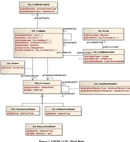
7.2 Fluid Bodies
These are distinct bodies of fluid (liquid or gas) that fill the voids in hydrogeological units. Fluid bodies are made of biologic (e.g. organisms), chemical (e.g. solutes), or material constituents (e.g. sediment). While it is expected that the major constituent of a fluid body will be water, the conceptual model allows for other types of major
constituents such as petroleum. Minor constituents are not necessarily fluids, but can be gases, liquids, or solids, and are included in the fluid body in various forms of mixture, such as solution, suspension, emulsion, and precipitates. Fluid bodies can also have other fluid bodies as parts, such as plumes or gas bubbles. Surfaces can be identified on a fluid body, such as a water table, piezometric or potentiometric surface, and some such
surfaces can contain divides, which are lines projected to the fluid surface denoting divergence in the direction of flow systems.
7.3 Voids
Voids are the spaces inside a unit (e.g. aquifer) or its material (e.g. the sandstone material of an aquifer), and might contain fluid bodies. Voids are differentiated from porosity, in that porosity is a ratio of void volume to total volume of unit plus voids, while voids are the spaces themselves. It is important to conceptually differentiate voids from units and their containers, in order to represent, for example, the volume of fractures, caves, or pores in a particular unit or portion thereof.
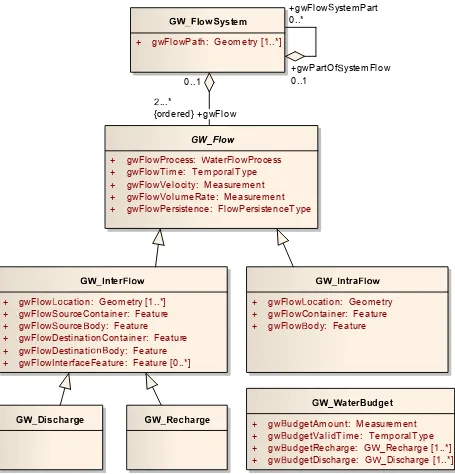
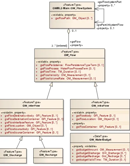
7.4 Flow
Groundwater flow denotes the process by which a fluid enters or exits a container (unit) or its voids, or flows within them. Flow between one container or void and another is named InterFlow, and flow within a container or void is named IntraFlow. Recharge is the flow into a groundwater container or void, and discharge is flow out of a groundwater container or void. The reciprocal source or destination entity can be any appropriate container or void such as a river, lake, pipe, dam, canyon, flood plain, etc. A flow system is then a collection of flows ordered in a sequence from recharge to discharge, such that the flow segments of the system make up a connected flow path from source to
destination. A water budget is a measure of the balance of recharge and discharge valid for a specific time and relative to a specific groundwater feature, such as a basin, aquifer, management area, or well.
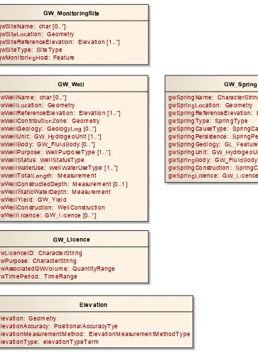
7.5 Wells
body. Monitoring sites are locations where devices are placed to measure various properties of significance to hydrogeology, such as water level, flow rate, water
temperature, or chemical composition, or to take samples. As such, monitoring sites are roles played by other features, for example, water wells or springs.
7.6 Conceptual Model Specification
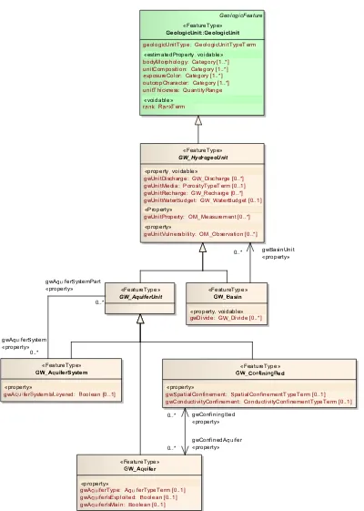
Figure 2: GWML2 CM - Hydrogeological Unit.
Wasin
gwDivide: G_Divide [1..*] LeolocUnit
gwUnitDescription: char [1..*] gwUnitMetadata: G_Metadata [1..*]
gwUnitName: char [1..*] gwUnitShape: Geometry
gwUnitThickness: Measurement
WCo inied
gwSpatialConfinement: SpatialConfinementType
gwConductivityConfinement: ConductivityConfinementType
Wq er
gwAferType: AferType
gwAferIsExploited: boolean
«Implementation»
gwAferIsMain: boolean
Wquierystem
gwAferSystemIsered: boolean
GW_HydrogeoUnit
gwUnitMedia: PorosityType gwUnitRecharge: G_Recharge [1..*]
gwUnitDischarge: G_Discharge [1..*]
gwUnitaterBudget: GaterBudget
gwUnitVulnerability: G_Vulnerability [0..*]
GW_AquiferUnit
WUnit
roperties
gwUnitProperty: gwUnitPropertyType gwUnitPropertyValue: Any
gwConfinedAfer
0..* gwConfininBed
0..*
gwUnitProperty
0..*
gwAferSystem 0..*
gwAferSystemPart
1..*
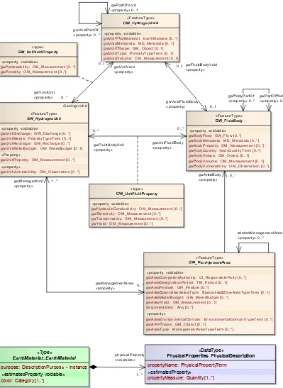
Figure 3: GWML2 CM - Groundwater Properties.
GL_GeologicUnit GW_HydrogeoUnit
gwUnitMedia: PorosityType gwUnitRecharge: G_Recharge [1..*]
gwUnitDischarge: G_Discharge [1..*]
gwUnitaterudget: Gaterudget
gwUnitVulnerability: G_Vulnerability [0..*]
nituidroperty
gwHydraulicConductivity: Measurement [1..*]
gwTransmissivity: Measurement [1..*] gwtorativity: Measurement [1..*]
uidBody
gwodyDescription: char [1..*]
gwodyFlow: G_Flow [1..*]
gwodyMetadata: G_Metadata [1..*]
gwodyQuality:odyQualityType [1..*]
gwody hape: Geometry
gwodyVolume: Measurement
gwodyVulnerability: G_Vulnerability [0..*] !ydr"#$"%oid
gwVoidDescription: char
gwVoi&HostMaterial: EarthMaterial [0..*]
gwVoidMetadata: G_Metadata
gwVoi& hape: Geometry
gwVoidType: PorosityType
gwVoidVolume: Measurement uidBodyroperty
gwodyProperty: gwodyPropertyType
gwodyPropertyValue: Measurement orosity
gwPorosityType: PorosityType gwPorosity: Measurement
Yield
gw'ieldType:'ieldType
gw'ield: Measurement nit%oidroperty
gwPermeability: Measurement [1..*]
%ulnerability
gwAreaName: char [1..*] gwAreaDescription: char gwAreaFeature: Feature [1..*]
gwAre*aterudget: Gaterudget [1..*]
gwAre*'ield: G 'ield
gwAre* hape: Geometry
gwAreaType: ManagementAreaType
gwAre* pecialisedAreaType: pecialise&+oneAreaTypeTerm
gwAreaEnvironmentalDomain: EnvironmentalDomainTypeTerm gwAreaCompetentAuthority: CI_ResponsibleParty [0..*] gwAreaDesignationPeriod: TM_Period
,-arth(aterial
gwVoidProperty: G_UnitVoidProperty
gwFluidProperty: G_UnitFluidProperty
«type»
gwVoidFlui&ody 0..1
gwAre*ody 0..*
gwPartOfody 0..1
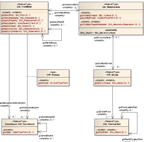
Figure 4: GWML2 CM - Fluid Body.
. /012uidBody
gw3odyDescription: char [1..*]
gw3odyFlow: G4_Flow [1..*]
gw3odyMetadata: G4_Metadata [1..*]
gw3odyQuality: 3odyQualityType [1..*]
gw3ody5hape: Geometry
gw3odyVolume: Measurement
gw3odyVulnerability: G4_Vulnerability [0..*]
./0Biol678cConstituent
gwOrganism: OrganismType
gw5urface5hape: 5urface
gw5urfaceType: 5urfaceType
gw5urfaceMetadata: ObservationMetadata . /0Div ide
gwDivi?95hape: Geometry
gwDivideFlow: G4_Flow5ystem [@C.*] ./012uidBodyEroperty
gw3odyProperty: gw3odyPropertyType
gw3odyPropertyValue: Measurement
GW_CIJKtituent
gwConcentration: Measurement gw5tateQ 5tateType
. /0=ixture
gwMiRture: MiRtureType
. /0ConstituentXelation
gwConstituentRelationType: ConstituentRelationType gwConstitutionRelationMechanism: MechanismType
gw3acZgroundConstituent
1..*
gw5urfaceDivide 0..*
Figure 5: GWML2 CM - Groundwater Flow.
GW_[\ow
+ gwFlowProcess: ]aterFlowProcess
+ gwFlowTime: TemporalType + gwFlowVelocity: Measurement + gwFlowVolumeRate: Measurement + gwFlowPersistence: FlowPersistenceType
^ `bclowgystem
+ gwFlowPath: Geometry [1..*]
^ `bintercjlw
+ gwFlowmpration: Geometry [1..*]
+ gwFlowsourceContainer: Feature
+ gwFlowsourcetody: Feature
+ gwFlowDestinationContainer: Feature
+ gwFlowDestinatiputody: Feature
+ gwFlowInterfaceFeature: Feature [0..*]
^`bintracjlw
+ gwFlowmpration: Geometry
+ gwFlowContainer: Feature
+ gwFlowtody: Feature
^ `b`aterBud vet
+ gwtudgetAmount: Measurement
+ gwtudgetValidTime: TemporalType
+ gwtudgetRecharge: G]_Recharge [1..*]
+ gwtudgetDischarge: G]_Discharge [1..*]
^ `byiz{|arve ^ `b}~{|arve
+gwFlowsystemPart
0..*
+gwPartOfsystemFlow
0..1 0..1
+gwFlow
...*
Figure 6: GWML2 CM - Wells.
ll
gwellName: char [0..*] gwell ation: Geometry
gwellReferenceElevation: Elevation [1..*] gwellContributione: Geometry gwellGeology: Geology 0..*] gwellUnit: GydrogeoUnit [1..*] gwellody: G_Fluiody [0..*] gwellPurpose: ellPurposeType [1..*] gwelltatus: elltatusType
gwellaterUse: ellaterUseType [1..*] gwellTotal h: Measurement
gwellConstructedDepth: Measurement [0..1] gwelltaticaterDepth: Measurement gwellield: Gield
gwellConstruction: ellConstruction gwell cence: G cence [0..*]
onitoriite
gwiteName: char [0..*] gwit ation: Geometry
gwiteReferenceElevation: Elevation [1..*] gwiteType: iteType
gwMonitoriost: Feature
pri
gwpringName: Charactertring [0..*] gwpri ation: Geometry
gwpringReferenceElevation: Elevation [1..*] gwpringType: pringType
gwpringCauseType: pringCauseType
gwpringPersistence: pringPersistenceType gwpringGeology: G
eature [0..*] gwpringUnit: GydrogeoUnit [1..*] gwpriody: G_Fluiody [0..*]
gwpringConstruction: pringConstruction [0..1] gwpri cence: G cence [0..*]
icence
gw cenceID: Character tring gwPurpose: Charactertring
gwAssociatedGVolume: QuantityRange
gwTimePeriod: TimeRange
lev ation
elevation: Geometry
elevationAccuracy: PositionalAccuracyTye
7.6.1 DocumentCitation
The class DocumentCitation is abstract, and has no attributes, operations or associations. It serves as a placeholder for legislative and reference documentation for a management area. Legislative documentation refers to the legal instrument or document that required the establishment of the management area. Reference documentation might describe the environmental objectives and measures that are to be undertaken in the management area to protect the environment (a reference to a management or action plan), licensing information, and associated maps.
The 'Legislation References' and 'DocumentCitation' classes from the INSPIRE Generic Conceptual Model are possible candidates for DocumentCitation.
Relation Source Target Description
Association Entity:
GW_ManagementArea
Role:
Entity:
DocumentCitation
Role: documentation
Relates legislative and reference
documentation to a management area.
7.6.2 Elevation
Elevation of a feature in reference to a datum.
Attribute Type and Multiplicity Definition
elevation Geometry Numeric value, coordinate reference system
(CRS), and unit of measure (UoM) for the elevation.
elevationAccuracy PositionalAccuracyType Description of the accuracy of the elevation
measurement.
elevationMeasure mentMethod
ElevationMeasurement MethodType
Method used to measure the elevation, e.g. GPS, Survey, DEM, etc.
elevationType elevationTypeTerm Type of reference elevation, defined as a feature,
e.g. Top of Casing, Ground, etc.
7.6.3 GL_EarthMaterial
Attribute Type and Multiplicity Definition
gwVoidProperty GW_UnitVoidProperty The porosity or permeability of a particular earth
material that hosts a void.
gwFluidProperty GW_UnitFluidProperty The hydraulic conductivity, transmissivity, or
storativity of an earth material.
7.6.4 GL_GeologicUnit
From GeoSciML:
Conceptually, may represent a body of material in the Earth whose complete and precise extent is inferred to exist (NADM GeologicUnit, Stratigraphic unit in sense of NACSN or International Stratigraphic Code), or a classifier used to characterize parts of the Earth (e.g. lithologic map unit like 'granitic rock' or 'alluvial deposit', surficial units like 'till' or 'old alluvium').
Attribute Type and Multiplicity Definition
gwUnitDescription char [1..*] Description of the unit.
gwUnitMetadata GW_Metadata [1..*] Metadata for the unit .
gwUnitName char [1..*] Name of the unit (common local name or formal
name).
gwUnitShape Geometry The geometry of the unit.
gwUnitThickness Measurement Typical thickness of the unit.
Relation Source Target Description
Generalization Entity:
GW_HydrogeoUnit
Role:
Entity:
GL_GeologicUnit
Role:
A hydrogeological unit is a type of geological unit.
7.6.5 GW_Aquifer
gwAquiferType AquiferType Water in an Aquifer is, or is not, under pressure. Based on that, several aquifer types can be distinguished: unconfined, confined, artesian, subartesian, or aquitard (after INSPIRE, 2013).
gwAquiferIsExploi ted
boolean Denotes whether groundwater from the
hydrogeological unit is being exploited by wells or other intakes (after INSPIRE, 2013).
gwAquiferIsMain boolean Denotes whether the unit is primary in an
Aquifer System (after INSPIRE, 2013).
Relation Source Target Description
Association Entity: GW_Aquifer
Role:
gwConfinedAquifer
Entity:
GW_ConfiningBed
Role: gwConfiningBed
Relates an aquifer and its confining beds.
Generalization Entity: GW_Aquifer
Role:
Entity:
GW_AquiferUnit
Role:
An aquifer is a type of aquifer-related unit.
7.6.6 GW_AquiferSystem
Aquifer system - a body of permeable and poorly permeable material that functions regionally as a water-yielding unit; it comprises two or more permeable beds separated at least locally by confining beds that impede groundwater movement but do not greatly affect the regional hydraulic continuity of the system; includes both saturated and unsaturated parts of permeable material (after ASCE, 1987).
Attribute Type and Multiplicity Definition
gwAquiferSystemIs Layered
boolean True if this aquifer / system is a layered system.
Relation Source Target Description
Generalization Entity:
GW_AquiferSystem
An aquifer system is a type of aquifer-related unit.
Relates an aquifer system with its parts, which can be other systems, aquifers or confining beds.
7.6.7 GW_AquiferUnit
Denotes aquifer-related hydrogeological units: aquifer systems, aquifers, or confining beds.
Relation Source Target Description
Generalization Entity: GW_AquiferUnit
Role: type of hydrogeological unit.
Generalization Entity:
GW_AquiferSystem
An aquifer system is a type of aquifer-related unit.
Relates an aquifer system with its parts, which can be other systems, aquifers or confining beds.
Generalization Entity:
GW_ConfiningBed
Entity:
GW_AquiferUnit
Role:
Role:
Generalization Entity: GW_Aquifer
Role:
Entity:
GW_AquiferUnit
Role:
An aquifer is a type of aquifer-related unit.
7.6.8 GW_Basin
A large hydrogeologically defined body of ground typically consisting of hydraulically connected hydrogeological units, whose waters are flowing to a common or multiple outlets, and which is delimited by a groundwater divide.
Attribute Type and Multiplicity Definition
gwDivide GW_Divide [1..*] “Line on a water table or piezometric surface on
either side of which the groundwater flow diverges" (IGH0556).
Relation Source Target Description
Generalization Entity: GW_Basin
Role:
Entity:
GW_HydrogeoUnit
Role:
A basin is a type of hydrogeological unit.
Aggregation Entity: GW_Basin
Role:
Entity:
GW_HydrogeoUnit
Role: gwBasinUnit
Relates
hydrogeological units and the basins that contain them, in full or part.
7.6.9 GW_BiologicConstituent
Attribute Type and Multiplicity Definition
gwOrganism OrganismType Biological species.
gwState StateType solid Organisms are always solids.
Relation Source Target Description
Generalization Entity:
GW_BiologicConstituen t
Role:
Entity:
GW_Constituent
Role:
A biologic constituent is a type of fluid body constituent. There are 3 types of fluid body constituents: chemical (e.g. arsenic), biologic (e.g. organisms), and material (e.g.
sediment).
7.6.10 GW_ChemicalConstituent
Characterization of the chemical composition of the fluid body, both natural and man-made.
Attribute Type and Multiplicity Definition
gwChemical ChemicalType Chemical component type, e.g. arsenic.
Relation Source Target Description
Generalization Entity:
GW_ChemicalConstitue nt
Role:
Entity:
GW_Constituent
Role:
A chemical constituent is a type of fluid body
constituent. The 3 types of fluid body constituent are: chemical (e.g. arsenic), biologic ( e.g. organisms), and material (e.g. sediment).
7.6.11 GW_ConfiningBed
gwSpatialConfine ment
SpatialConfinementType Degree of spatial confinement (typically:
"Unconfined-Confined", "Partially Confined").
gwConductivityCo nfinement
ConductivityConfinemen tType
Degree of hydraulic confinement (e.g. aquiclude).
Relation Source Target Description
Association Entity: GW_Aquifer
Role:
gwConfinedAquifer
Entity:
GW_ConfiningBed
Role: gwConfiningBed
Relates an aquifer and its confining beds.
Generalization Entity:
GW_ConfiningBed
Role:
Entity:
GW_AquiferUnit
Role:
A confining bed is a type of aquifer-related unit.
7.6.12 GW_Constituent
General (abstract) entity denoting a material, chemical or biological constituent of a fluid body.
Attribute Type and Multiplicity Definition
gwConcentration Measurement The concentration (with uom) of the constituent
in the fluid body.
gwState StateType The physical state of the constituent, i.e. solid,
liquid, or gas.
Relation Source Target Description
Association Entity: GW_FluidBody
Role:
Entity:
GW_Constituent
Role:
gwBackgroundConstitu
Relation Source Target Description
ent
AssociationClass Entity: GW_Constituent
Role: gwConstituent
Entity:
GW_Constituent
Role: gwConstitutedOf
A general binary relation between constituents, in which the relation type can be specified in addition to the causal mechanism that caused the
relationship.
Generalization Entity:
GW_BiologicConstituen
A biologic constituent is a type of fluid body constituent. There are 3 types of fluid body constituents: chemical (e.g. arsenic), biologic (e.g. organisms), and material (e.g.
sediment).
Generalization Entity:
GW_ChemicalConstitue
A chemical constituent is a type of fluid body constituent. There are 3 types of fluid body constituents: chemical (e.g. arsenic), biologic (e.g. organisms), and material (e.g.
sediment).
Generalization Entity:
GW_MaterialConstituen
A material constituent is a type of fluid body constituent. There are 3 types of fluid body constituents: chemical (e.g. arsenic), biologic (e.g. organisms), and material (e.g.
sediment).
AssociationClass Entity: GW_FluidBody Entity:
GW_Constituent
Role:
Role:
gwBodyConstituent
constituents, and specifies the nature of the mixture of the constituent within the body, e.g. solution, suspension.
7.6.13 GW_ConstituentRelation
Relation between fluid body components, typically caused by a specific mechanism, e.g. coating (from adsorption), constitution (from chemical bonding forming a new material), aggregation (from physical bonding, e.g. pressure), containment (from absorption, digestion).
Attribute Type and Multiplicity Definition
gwConstituentRela tionType
ConstituentRelationType Specific type of relation between fluid body
components, e.g. coating, constitution, aggregation, containment.
gwConstitutionRel ationMechanism
MechanismType Mechanisms by which materials (of various
states) come into a relationship, e.g. sorption, precipitation, digestion, excretion, etc.
7.6.14 GW_Discharge
An outflow of fluid from a container such as an aquifer, watershed, pipe.
Relation Source Target Description
Generalization Entity: GW_Discharge
Role:
Entity: GW_InterFlow
Role:
Discharge is a type of interflow in which fluid exits a feature.
7.6.15 GW_Divide
“A line on a water table or piezometric surface, on either side of which the groundwater flow diverges" (IGH0556).
Attribute Type and Multiplicity Definition
gwDivideShape Geometry Shape / position of the divide (line, plane or
Attribute Type and Multiplicity Definition
gwDivideFlow GW_FlowSystem [2..*] Flow system on each side of the divide.
Relation Source Target Description
Association Entity: GW_Divide
Role: gwSurfaceDivide
Entity:
GW_FluidBodySurface
Role: gwDivideSurface
Relates a fluid body surface to a line on e.g. a water table or
piezometric surface, on either side of which the groundwater flow diverges.
7.6.16 GW_Flow
Process by which the fluid enters or exits a hydrogeological unit or a void, or flows within a unit or a void. Can flow from/to other natural or man-made features such as rivers, filtration stations, etc.
Attribute Type and Multiplicity Definition
gwFlowProcess WaterFlowProcess The process causing the flow, e.g.
evapotranspiration, evaporation, transpiration, runoff, baseflow, pumping, infiltration, injection, etc.
gwFlowTime TemporalType Refers to the duration, instant or interval of the
flow (actual time, not observation time). E.g. "yearly", "summer", "2009" or "2009-2011".
gwFlowVelocity Measurement Measure of water volume per unit of time.
gwFlowVolumeRat e
Measurement Measure of water quantity per time period with
uom.
gwFlowPersistenc e
FlowPersistenceType The regularity of flow occurrence, e.g.
ephemeral, intermittent, perennial, seasonal. After
http://inspire.ec.europa.eu/codeList/WaterPersist enceValue/ (INSPIRE, 2013).
Generalization Entity: GW_InterFlow
Role:
Entity: GW_Flow
Role:
An interflow is a type of directed flow between two features, e.g. flow between two units.
Generalization Entity: GW_IntraFlow
Role:
Entity: GW_Flow
Role:
An intraflow is a type of flow within a single feature, e.g. flow within a unit.
Aggregation Entity: GW_FlowSystem
Role:
Entity: GW_Flow
Role: gwFlow
Relates a flow system to the individual flows that comprise the system. Flows are atomic entities that cannot have parts, but which form parts of flow systems.
7.6.17 GW_FlowSystem
Flow path from recharge to discharge location, through hydrogeological units. It is related to a fluid body, and consists of a collection or aggregation of at least two specific flows, as well as possibly other flow systems.
Attribute Type and Multiplicity Definition
gwFlowPath Geometry [1..*] The path of flow of a fluid through a container.
Relation Source Target Description
Association Entity: GW_FlowSystem
Role:
Relates a flow system part to a flow system whole.
Relation Source Target Description
Role:
Role: gwFlow to the individual flows
that comprise the system. Flows are atomic entities that cannot have parts, but which form parts of flow systems.
7.6.18 GW_FluidBody
A distinct body of some fluid (liquid, gas) that fills the voids of a container such as an aquifer, system of aquifers, water well, etc. In hydrogeology this body is usually
constituted by groundwater, but the model allows for other types of fillers e.g. petroleum.
Attribute Type and Multiplicity Definition
gwBodyDescriptio n
char [1..*] General description of the fluid body
gwBodyFlow GW_Flow [1..*] Flows associated with the fluid body.
gwBodyMetadata GW_Metadata [1..*] Metadata about the fluid body.
gwBodyQuality BodyQualityType [1..*] Categorical assessment of quality of the fluid
body as a whole: e.g. saline, brackish, fresh, turbide, sulfurous, mixed, ... 1000-3000mg/l tds, etc.
A normative quality description is an assessment based upon some guideline edited by a
government or a quality standard.
gwBodyShape Geometry Shape and position of the fluid body.
gwBodyVolume Measurement Description of the volume/quantity of a fluid
present in a container at a certain time.
gwBodyVulnerabil ity
GW_Vulnerability [0..*]
The susceptibility of the fluid body to specific threats such as surface contamination, etc.
Relation Source Target Description
Association Entity: Entity: GW_FluidBody Relates a void and a