IMAGE BASED 3D CITY MODELING: COMPARATIVE STUDY
Surendra Pal Singh1a*, Kamal Jain1b
,
V. Ravibabu Mandla2 1aGeomatics Engineering Section, Department of Civil Engineering, Indian Institute of Technology, Roorkee, (Roorkee), India. Corresponding author1a*Email- ([email protected]),
1b
Geomatics Engineering Section, Department of Civil Engineering, Indian Institute of Technology, Roorkee, (Roorkee), India. 1b E-mail ([email protected])
2
School of Mechanical and Building Sciences, Vellore Institute of Technology(VIT)-University,Vellore, Tamilnadu, India
.
2E-mail([email protected])
ISPRS Technical Commission V Symposium
KEY WORDS: Virtual 3D city model, Sketch based 3D model, Procedural grammar based 3D model, Close Range Photogrammetry based 3D model, Computer Vision based 3D model.
ABSTRACT:
3D city model is a digital representation of the Earth’s surface and it’s related objects such as building, tree, vegetation, and some manmade feature belonging to urban area. The demand of 3D city modeling is increasing rapidly for various engineering and non-engineering applications. Generally four main image based approaches were used for virtual 3D city models generation. In first approach, researchers were used Sketch based modeling, second method is Procedural grammar based modeling, third approach is Close range photogrammetry based modeling and fourth approach is mainly based on Computer Vision techniques. SketchUp, CityEngine, Photomodeler and Agisoft Photoscan are the main softwares to represent these approaches respectively. These softwares have different approaches & methods suitable for image based 3D city modeling. Literature study shows that till date, there is no complete such type of comparative study available to create complete 3D city model by using images.
This paper gives a comparative assessment of these four image based 3D modeling approaches. This comparative study is mainly based on data acquisition methods, data processing techniques and output 3D model products. For this research work, study area is the campus of civil engineering department, Indian Institute of Technology, Roorkee (India). This 3D campus acts as a prototype for city. This study also explains various governing parameters, factors and work experiences. This research work also gives a brief introduction, strengths and weakness of these four image based techniques. Some personal comment is
also given as what can do or what can’t do from these softwares.
At the last, this study shows; it concluded that, each and every software has some advantages and limitations. Choice of software depends on user requirements of 3D project. For normal visualization project, SketchUp software is a good option. For 3D documentation record, Photomodeler gives good result. For Large city reconstruction; CityEngine is a good product. Agisoft Photoscan software creates much better 3D model with good texture quality and automatic processing. So this image based comparative study is useful for 3D city user community. Thus this study will provide a good roadmap for geomatics user community to create photo-realistic virtual 3D city model by using image based techniques.
1. INTRODUCTION
At present scenario, there are four main image based techniques available to create virtual 3D city model. First, sketch based method, second is procedural based method, third close range photogrammetry based method and fourth technique based on computer vision algorithms.
SketchUp, CityEngine, Photomodeler and Agisoft Photoscan are the main softwares to represent these approaches respectively. Sketch based modeling is simple and not fulfill the engineering requirements. Procedural based modeling is also not easy for normal user. Close range photogrammetry based method is also not suitable for large landscape modeling. Previous available research literature shows that each and every method has some advantages & limitations. Previous study shows that, till date, there is a no perfect
comparative study available to study the image based 3D city model. Thus this research paper will fulfill the required gap in 3D modeling community to create 3D city model in efficient way.
Some previous literature, related with this work summarized as given below:
A good collection of literature can be found on image based 3D city modeling techniques and applications (Singh et al., 2013c), Image based 3D modeling: a review (Remondino, Fabio, and Sabry El-Hakim., 2006).
Zhou and Zhang (2004) explained about a preliminary review on three-dimensional city model. This review was based on the comparison of three 3D data model of GIS, (3D FDS, V3D, GeoToolKit).
Wang (2011), explained about a comparative study of five 3D modeling systems based on the SfM principles. He has taken only four software; Bundler, PMVS2, Project Photofly (Autodesk), and ARC 3D Web Service in their work. The working principle of these software is same ie. computer vision based technique, mainly Structure from Motion (SfM).
The literature study shows that, till date, there is no complete such type of comparative study available for 3D city modeling user community. So this research paper will fulfill gap and useful for image based 3D city modeling community.
The main purpose of this paper is to find out the suitable software for 3D city modeling project. In this research work, SketchUp, CityEngine, Photomodeler and Agisoft Photoscan software, were explained. This comparative study is based on mainly, general overview of software, method of image data acquisition, data processing methods, and result of output 3D model. This study shows that every software has some advantages and limitations.
This research paper will play an important role for 3D city modeling scientist community. At the last, the strengths and weakness of these four images based 3D city modeling software are explored. With the help of this paper, they can easily understand that, which software is more suitable for which project. Choice of software depends on user requirements.
2. STUDY AREA
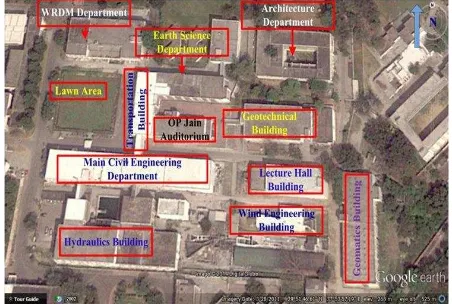
Study area is civil engineering department, Indian Institute of Technology, Roorkee, (IIT-R), Uttarakhand, India. The civil engineering department surrounded by department of earth science, department of architecture, department of water resources development and management (WRD&M), and this civil engineering department (CED) has the following main sections and buildings: Geomatics section building, Geotechnical section building (having CAD Lab and Research scholar wing), Lecture hall building (having Newton rooms and Rayleigh rooms), Wind engineering section, O.P. Jain auditorium building, Transportation
Figure 1: Civil Engineering Department (CED), IIT-Roorkee (Source: Google Earth, January 2014)
3. GENERAL OVERVIEW: COMPARISON OF THE IMAGE BASED 3 CITY MODELING SOFTWARES (Sources: Web-references)
The detail about this section is given in Annexure 1:
4. COMPARATIVE STUDY BASED ON DATA
ACQUISITION:
In SketchUp and CityEngine software, photographs should be taken from front shoot of building. Photographs can be taken for each important feature of building façade. So in this type of photography, more detail will obtain. Editing of photograph is essential and can be done by any photo-editing software like Photoshop software and camera calibration is not required.
For Photomodeler software, only convergent photography is useful. Convergent photographs are the photographs in which pairs of photo taken with camera so directed that their optical axes converge. Photomodeler works on basic principles of close range photogrammetry. For any close range photogrammetric project, photos should be taken according
to; “3X3 rules”, given by Waldhausl and Ogleby, 1994, and
further explained by Shashi and Jain, (2007b). These rules are the best suitable for any close range photogrammetric image acquisition with amateur cameras. (Shashi and Jain, 2007b, Singh et al., 2012, Singh et al., 2013d).
Photomodeler generates the 3D positions of points by projecting straight lines from the camera position, through the point on the film or CCD and out into space. When two such rays are used, the intersection of the rays gives the point position. (Photomodeler)
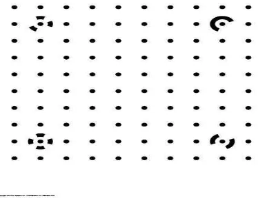
Camera calibration is an essential step for Photomodeler project (Singh et al., 2013d). Camera calibration is the process of determining characteristics of a camera so it can be used as a measurement device. (W. Zhang et al., 2010).
Figure 2. Camera calibration grid for Photomodeler
Figure 3. Images of camera calibration grid taken from
camera (for Photomodeler project) (Singh et al., 2012)
We should follow the following main points during photography to obtained the best result from Photomodeler software,. [Photomodeler]
1. One should try to get the angles between the shots as close to right angles (90 degrees) as possible. 2. One should try to take at least three photographs but
more photographs will be useful because the returning of a person on project site will increase the work load and cost of project.
3. One should try to get all important points on at least three photographs.
4. One should try to get as much overlap between adjacent photographs as possible.
5. One should try to get photographs from both above and below the object, if possible.
6. One should take a special care to ensure good exposure and good focus.
7. One should also take accurate measurement of the distance between two clearly visible points in the scene that will be later useful to scale a close range photogrammetry project.
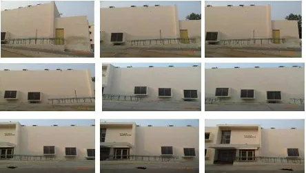
Figure 4, is showing the example of some photographs, suitable for photomodeler project.
Figure 4. Showing photographs for multi-images project
(for Photomodeler software)
Photomodeler gives good result for curves, edge, and cylinders, so special care is needed for photography of these features.
For any close range photography project, initial planning will also play an important role for successful result. First, one should try to decide, how many photographs will take and from where to take them. After that visit on project site and take the photographs. Special care should be taken to ensure better exposure and good focus.
3D model is also possible by using single photograph in Photomodeler software. For single photograph project, the main requirements are:
1. he photographs should be clear and with good focus. 2. For good result, the known objects (shapes, control
points, constrained edges & lines) should be very clearly visible and should be spread out over the photograph. 3. For single photograph project, if someone is trying to
recover all the camera parameters in an inverse camera procedure, the photograph should be in three point perspective (i.e. have three vanishing points). For this, one should take a picture of building from its corner instead of face-on.
Figure 5. Showing photographs for single-image project
fx, fy - focal length
cx, cy - principal point coordinates
K1, K2, K3, P1, P2 - radial distortion coefficients,
using Brown's distortion model
Figure 6, is showing the camera calibration grid for Agisoft Photoscan. Camera calibration is essential for photomodeler 3D project but it is not necessary for Agisoft Photoscan project. Camera calibration is not useful for SketchUp and CityEngine software.
Figure 6. Camera calibration grid (Chess board) in Agisoft
Lens
Following are the main points to remember during the capturing the photographs for camera calibration in Agisoft :
1. In case of zoom lens, focal length should be keep constant (or fixed) throughout the session of photography.
2. Glare should be avoided on the photo and move the light sources away if required.
3. Preferably, the whole area of the photos should be covered by calibration pattern and move the camera closer to the LCD screen if required.
One should follow the following main points during photography for Agisoft Photoscan 3D reconstruction project.
1. One should choose high resolution digital camera (More than 5 MP).
2. One should choose wide angle lenses because these lenses are more suitable for reconstructing spatial relations between objects than telephoto ones.
3. One should avoid non-textured and flat object or scenes.
4. One should avoid shiny and transparent objects.
transform the images.
10.More photos are better than not enough.
11.Before taking the images, spending some time for shot plan might be very useful.
12.Reference coordinate system is also possible for reconstructed 3D model.
13.One should also measure reference distance.
Figure-7, showing the example of some photographs, suitable for Agisoft Photoscan project.
Figure 7. Some photographs suitable for Agisoft Photoscan
software
Table 1, is showing the mode of photography and image input format for these softwares.
Table 1. Comparison of mode of photography and image
input format
Software Mode of
Photography
Format of input Image
SketchUp Feature based
photography
.jpg, .png, .psd, .tif, .tga, .bmp
CityEngine Feature based
photography
.jpg, or any other image
format
Photomodeler Convergent
photography
.jpg, .tif, .bmp, .pcx, .tga, .png, .pct, .psd, .ppm, .mac, .iff, .cal, .pcd, .sgi, .rgb, Jpeg2000 (.jp2/.jpx), .hpd/.wdp
Agisoft
Photoscan
Parallel
photography
.jpg, .tif, .png, .bmp, .jpeg,
Multi-Picture Format
5. COMPARATIVE STUDY BASED ON DATA More details of methodology can be seen in Ref Singh et al. 2013b.
CityEngine software mainly works on procedural programming language or also called as Procedural modeling. But it also has the facility to work on image based modeling. Image based modeling approach is easy and simple than procedural programming approach. More detail of methodology based on image based technique in CityEngine software is briefly described by Singh et al. (2014b)
Photomodeler software works on close range photogrammetric principle. It is a good software for 3D model reconstruction by using close range photographs. More detail of close range photogrammetric method and work is described by Shashi and Jain (2007a), Singh et al. (2012), (2013d).
Agisoft Photoscan software works mainly on computer vision based techniques. Structure from Motion (SfM), and multi-view reconstruction techniques are main principles on which Agisoft create 3D model of an object. In this software, both image alignment and 3D model reconstruction are fully automated. With the help of Agisoft Photoscan, 3D scene reconstruction is also possible by using video data. Singh et al., 2014a.
6. COMPARATIVE STUDY BASED ON
METHODOLOGY: Please see Annexure 2.
7. COMPARATIVE STUDY BASED ON OUTPUT 3D
MODEL: Please see Annexure 3.
7.1. Summary of Output model format, Export and Import facility: (Please see table 3)
Table 3.
Software Processing Method (Basic
working principle)
SketchUp Computer Graphics techniques- (Sketch-based modeling approach) CityEngine Procedural programming language
Photomodeler Close Range Photogrammetry
Agisoft Photoscan Computer Vision based techniques (SfM and Multi-view reconstruction approach) Photomodeler (.pmr) DXF, Wavefront
this software. elements can also be added. 7.Import of city model
from other formats can be directly open in CityEngine and
of input images
The detail about this section is given as:
Name of Software
What can do What cannot do
SketchUP 1. For straight building, it 3. It gives terrain
from Google
1. Rendering is not possible
ANNEXURE 3:
10. CONCLUSION:
SkechUp software is an easy and useful tool to create 3D city model. CityEngine works on procedural modeling but also has image based approach to create 3D city model. It gives good realistic virtual scene of a large area in less time. Photomodeler software is works on close range photogrammetric principles and has good measurement accuracy. Agisoft Photoscan works of computer vision based algorithms and gives good 3D model products. So the final conclusion of this work is: these softwares are good and most suitable for image based 3D city modeling. According to user requirement, one can use these softwares. If user wants only a simple 3D city model for visualization purpose, then SkechUp gives a good solution. If user wants only good visualization in less time, then CityEngine gives the best solution. Photomodeler is the best solution for photogrammetric documentation of a city. It gives the best measurement accuracy. Agisoft Photoscan is also gives good 3D model and most of the work done automatic and easy to use. The study area is Civil Engineering Department (CED), Indian Institute of Technology-Roorkee, India.
The main aim of this research paper is, to explore and analyze the potential of various image based 3D city modeling software and to find out a simple and cost effective image based photogrammetric method for 3D modeling user community. This study is based on a small area like campus of any educational institute. 3D model of any educational institute is acts as a prototype of a large city. With the help of this study, anyone can find the suitable method and software to create image based 3D city model. Choice of software depends on user requirements. This study is also useful for various kinds of engineering and non-engineering 3D applications.
ACKNOWLEDGMENT
Hyderabad, 22-24, January.
Singh, Surendra Pal, Mandla, V. Ravibabu, Jain, Kamal,
2012, “3D building modeling from close range photogrammetry”, International conference in Geomatrix-12, Feb 26-29, CSRE, Indian Institute of Technology-Bombay, India.
Singh, Surendra Pal, Jain, Kamal, Mandla, V. Ravibabu, 2013a, “Image based 3D modeling of campus (Department of Civil Engineering, IIT Roorkee, Uttarakhand, India) by using SketchUp”, International Journal of Advanced Civil Engineering and Architecture Research, September, Volume 2, Issue 1, pp. 65-71, Article ID Tech-168.
Singh, Surendra Pal, Jain, Kamal, Mandla, V. Ravibabu, 2013b, “Virtual 3D campus modeling by using close range photogrammetry”, American Journal of Civil Engineering and Architecture, Vol.1, No.6, Page-200-205. December, doi: 10.12691/ajcea-1-6-9.
Singh, Surendra Pal, Jain, Kamal, Mandla, V. Ravibabu, 2013c, “Virtual 3D city modeling : Techniques and applications”, International Archives of the Photogrammetry, Remote Sensing and Spatial Information Sciences,Volume XL-2/W2, ISPRS 8th 3DGeoInfo Conference & WG II/2 Workshop, 27 – 29 November, Istanbul, Turkey.
Singh, Surendra Pal, Jain, Kamal, Mandla, V. Ravibabu, 2013d, “Design and calibration of multi camera setup for 3D city modeling”, International Journal of Engineering Research & Technology (IJERT), Vol. 2, Issue 5, May.
Singh, Surendra Pal, Jain, Kamal, Mandla, V. Ravibabu, 2014a, “Image based virtual 3D campus modeling by using
CityEngine”, American Journal of Engineering Science and
Technology Research,Vol.2,No.1, January 2014, PP: 01-10, ISSN: 2327-8269 (Online)
Singh, Surendra Pal, Jain, Kamal, Mandla, V. Ravibabu, 2014b, “3D scene reconstruction from video camera for virtual 3D city modeling”, American Journal of Engineering Research (AJER), Volume-03, Issue-01, January, pp-140-148.
Shashi M. and Jain Kamal, 2007a, “Use of photogrammetry in 3D modeling and visualization of
buildings”, Asian Research Publishing Network (ARPN) - Journal of Engineering and Applied Sciences, Vol. 2, No. 2, April, ISSN 1819-6608.
Shashi M. and Jain Kamal, 2007b, “Use of amateur camera in architectural photogrammetry”, Map World Forum, Hyderabad, India.
Waldhäusl P.,Ogleby C., (1994), “3x3Rules for simple photogrammetric documentation of architecture”, J.G.Fryer
Report 2011-01. Visualize Inc., Goleta, USA.
Zhou Qiming and Zhang Wenjiang (2004), “A preliminary review on three-dimensional city model”, Geo-spatial Information Science (Quarterly), June, Volume 7, Issue 2.
Web-References:
http://www.sketchup.com/ (access on date June15, 2013)
http://en.wikipedia.org/wiki/SketchUp
http://www.esri.com/software/cityengine (access on date June 15, 2013)
http://en.wikipedia.org/wiki/CityEngine
http://www.photomodeler.com/index.html (access on date June 20, 2013)
http://en.wikipedia.org/wiki/PhotoModeler