UNDERSTANDING THE COORDINATE SYSTEMS
A THESIS
Submitted in Partial Fulfillment of the Requirement for the Degree of
Master of Science (M.Sc)
in
International Master Program on Mathematics Education (IMPoME)
Faculty of Teacher Training and Education Sriwijaya University
(in collaboration between Sriwijaya University and Utrecht University)
By
EVANGELISTA LUS WINDYANA PALUPI
NIM. 20112812003
FACULTY OF TEACHER TRAINING AND EDUCATION
SRIWIJAYA UNIVERSITY
ABSTRACT
This study deals with the challenge of making an educational innovation in teaching and learning coordinate system for the 10-12 year old elementary students. In order to help the students understand about the mathematical ideas of the coordinate systems we designed a six-step learning sequence (hypothetical learning trajectories/ HLT) based on Pendidikan Realistik Matematika Indonesia; an adaption of the Realistic Mathematics Education. In reaching the aim of this study which is to contribute to the local instructional theory of the coordinate system topic and in answering the proposed research question by examining how the designing activities can helps the students to learn and understand about the coordinate system, design research is employed in this study. The six designed activities and the HLTs are tested in the preliminary teaching (cycle 1, involved eight students of Grade 5), revised, and tested again in the classroom experiment (cycle 2, involved 34 students of Grade 5). These activities are implemented continuously in each cycle. Video and audio recordings, field notes, students’ works, pre test and post test are the data collected in this study. This data then is analyzed. Our analysis is focused on how the designed activities help the students to understand the mathematical ideas behind the coordinate system. The findings suggest that the proposed contexts or activities (seat map of cinema, seat map of airplane, locate the sunken ship, modified rice field) which are combined with the teacher’s questioning can make the students (participant of this study) think about the mathematical ideas of the coordinate systems. It can enhance students’ understanding and brings out the students’ different level of approaches and thinking of the ideas behind the coordinate system.
ABSTRAK
Penelitian ini menjawab tantangan dalam membuat sebuah inovasi dalam mengajarkan sistem coordinate di sekolah dasar. Kami mendesain enam aktifitas (hypothetical learning trajectories/ HLT) untuk membantu siswa kelas 5 dan 6 (10-12 tahun) memahami ide matematika dari sistem koordinat. Keenam aktifitas tersebut didesain berdasarkan karakteristik dari Pendidikan Realistik Matematika Indonesia (PMRI); adaptasi dari realistic mathematics education (RME). Penelitian ini bertujuan untuk memberikan kontribusi dalam local instructional theory mengenai koordinat sistem. Untuk itu, design research digunakan sebagai alat dan metodologi dalam penelitian ini. Desain aktifitas dan HLT diujicobakan dalam preliminary teaching (siklus 1, melibatkan 8 siswa kelas 5), direvisi, dan diimplementasikan dalam classroom teaching expereiment (siklus 2, melibatkan 34 siswa kelas 5). Keenam aktifitas tersebut diujicobakan secara berkelanjutan dalam setiap siklusnya. Video dan audio recording, field notes, dan dokumen hasil kerja siswa, hasil dari pre test dan post test adalah data yang dikumpulkan dalam penelitian ini yang kemudian dianalisis. Analisis difokuskan untuk menjawab pertanyaan penelitian yaitu, bagaimana aktifitas yang telah didesain dapat membantu siswa untuk memahami ide matematis dari koordinat sistem. Berdasrkan hasil analisis dapat disimpulkan bahwa siswa belajar mengenai koordinat sistem dari sesuatu yang riil ke abstrak. Mereka belajar megenai koordinat sistem melalui (masalah/aktifitas) konteks yang diberikan (bioskop, pesawat, melokasikan kapal tenggelam 1&2, sawah, dan Cartesian koordinat sistem). Konteks yang meaningful bagi siswa, dikombinasikan dengan pertanyaan yang diajukan oleh guru membuat siswa untuk berpikir mengenai ide matematika yang dibahas. Hal ini mendorong pemahaman siswa dan dapat memunculkan strategi siswa yang berbeda dalam menyelesaikan masalah yang diberikan.
TABLE OF CONTENT
2.1 The coordinate systems and its importance ... 5
2.2 Coordinate system in the Indonesian curriculum ... 6
2.3 Students’ difficulties in learning coordinate system ... 8
2.4 Situate the Research ... 9
2.5 Reinventing and Understanding the Coordinate Systems ... 11
2.6 (Indonesia) Realistic Mathematics Education Aspect in This Study ... 13
2.7 The Role of the Teacher ... 15
3.3.2 Preliminary teaching experiment (first cycle)... 22
3.3.3 Teaching experiment (second cycle) ... 22
CHAPTER IV HYPOTHETICAL LEARNING TRAJECTORY ... 29
4.1 Activity 1: Seat map of a plane (What is a good system?) ... 29
4.2 Activity 2: Seat map of a cinema (How a system works?) ... 33
4.3 Activity 3: Sunken Ship 1 (Make a System to locate a sunken ship) ... 36
4.4 Activity 4: Playing in the Paddies fields (where is your origin point?) ... 39
4.5 Activity 5: Sunken ship 2 (Locate the ships with the help of grids) ... 44
4.6 Activity 6: Cartesian coordinate system ... 47
4.7 Learning Scheme: Understand the Coordinate Systems ... 51
CHAPTER V TESTING HYPOTHETICAL LEARNING TRAJECTORY 52 5.1 Design Experiment ... 52
5.1.1 Preliminary Teaching (Cycle 1) ... 52
5.1.2 Classroom Teaching Experiment (Cycle 2) ... 54
5.2 Retrospective Analysis ... 57
5.2.1 Preliminary Teaching (Cycle 1) ... 58
5.2.2 Conclusion of the first cycle ... 67
5.2.3 Refined HLT ... 68
5.2.4 Overview of the students ... 70
5.2.5 Overview of the teacher ... 71
5.2.6 Classroom Teaching Experiment (Cycle 2) ... 72
5.2.7 Conclusion of the second cycle ... 108
CHAPTER VI CONCLUSION AND SUGGESTION ... 109
6.1 Conclusion ... 109
6.2 Reflection ... 112
6.2.1 Social Norm and Socio Mathematics Norm ... 112
6.2.2 (Indonesian) Realistic Mathematics Education ... 114
6.2.3 Role of the teacher ... 114
6.2.4 Students’ developmental level of locate a point ... 114
6.3 Suggestion for teaching, design, and research ... 115
6.3.1 Suggestion for teaching and Instructional design ... 115
6.3.2 Suggestion for the future research ... 116
References ... 117
LIST OF TABLES
LIST OF SCHEME
LIST OF FIGURES
Figure 5.1 System made by the student to locate the sunken ship ... 63
Figure 5.2 Ticket of a cinema ... 75
Figure 5.3 Seat map of a cinema ... 75
Figure 5.4 The answer of Group 2, there are 17 seats in a row ... 76
Figure 5.5 The answer of Group 8 that state that the number of the seats in each row is different ... 76
Figure 5.6 Students' different answers of the location of F9 and F10 ... 77
Figure 5.7 The way students' count the seats in row F ... 77
Figure 5.8 Students' answer which states that the position of F9 is behind E9 .... 81
Figure 5.9. Students’ answer which shows the relationship of F9 and F10 ... 82
Figure 5.10 Systems made by the students to locate the seats of an airplane ... 83
Figure 5.11 System to number plane’s seats made by Group 6 ... 86
Figure 5.12 Students locate the sunken ship by only consider the direction ... 88
Figure 5.13 A system made by the students which consider the distance and direction ... 89
Figure 5.14 A system made by students the which consider the distance and two dimensions measurement (north and east) ... 91
Figure 5.15 Students make up a system to locate a sunken ship by involving an angle .... 93
Figure 5.16 Possible locations of the lost watch pointed by group 3 ... 94
Figure 5.17 Naufal's answer of another possible location of the watch ... 95
Figure 5.18 The possible origins ... 96
Figure 5.19 Students' answer of the watch's location ... 97
Figure 5.20 Students' misinterpretation of the word "turn/ belok" ... 97
Figure 5.21 Students' misinterpretation on the word "go straight/ lurus" ... 98
Figure 5.22 Walk path made by Group 2 ... 99
Figure 5.23 Walk path made by Group 2, 6, and 8 ... 99
LIST OF APPENDICES
A. A list of the topics for the classroom observation ... 119
B. Interview scheme ... 120
C. Refined Learning Sequence Scheme ... Error! Bookmark not defined.22 D. Teacher Guide ... 123
E. Pre Test ... 149
F. Students’ Worksheet Bahasa Indonesia ... 152
1 CHAPTER I
1 INTRODUCTION
1.1 Background
Coordinate system is an important topic that should be learnt by students. Not only because it is an important component of graph and map reading (Blades & Spencer, 2001) or because it is an important factor in spatial development (Dickson, Brown, & Gibson, 1984) but also because it helps to organize the world. The coordinate systems also help us to communicate a location of an object easily and precisely. For instance, we can easily find a certain book in the library by looking at the code put on the books. That code is a coordinate system.
We cannot ignore the fact that we live in the coordinate system. We can find the coordinate systems everywhere. Our sitting arrangement in class, the houses in avenue, books in the library, and paragraphs in articles are some examples of the coordinate systems. So, coordinate system is everywhere and rich of sources/ context.
Although coordinate system is rich of contexts, it is rare to see the context used in teaching the coordinate system. In Indonesia, coordinate system is directly introduced to the students. Students only had given its form (how it looks like), its notation and its rule and they need to remember it. So in the first time the students learn about coordinate system, they directly and only learn the formal level of it. If there is context used in the learning the coordinate system then it is only used to introduce the topic or it is used to test the students’ understanding. Yet, it does not
2
the applications problem and be addressed in the end of learning sequence (Gravemeijer & Doorman, 1999).
Moreover, the common way of teaching of coordinate systems, which is only focus on its formal level and only require the students to remember the rules, leaves out the mathematical ideas of the coordinate systems. In other words, the mathematical ideas like the idea of origin and the idea that each point is unique are missed to be addressed. Hence, the students do not have a deep understanding of coordinate system. They might know that coordinate system is used to locate a point, but they do not understand how a good coordinate system should locate that point. Or why they have to start to locate from the certain point.
Without deep understanding of the coordinate system, students might face difficulties in learning it. Based on Sarama et.al. (2003) students tend to reverse x and y axis, especially when they have to plot point that have 0 in its coordinate (e.g. (0,6). In addition, some of students sometimes ignore the origin. They plot a new point started from the previous point, not the origin.
In order to help the students understand the coordinate system and the mathematical ideas behind it, we have to moves away from the current way of teaching coordinate system. We have to make innovation, so the learning can become meaningful for the students. This is in line with the current thinking of education in Indonesia starts to moves away from the transferring knowledge to teaching meaningfully (Sembirig, Hoogland, & Dolk, 2010).
3
coordinate system. Rrealistic mathematics education (RME) and also Pendidikan Realistik Matematika Indonesia (PMRI) which is adaptation of RME suggest that instead of start the learning from the formal level, it is better if we start it from the informal level in which we used the ‘real’ meaningful context that near and
familiar with the children. Rich and meaningful context which is combined with teacher’s probing question can enhance students’ thinking and understanding
(Widjaja, Dolk, & Fauzan, 2010). This is in contrast with the common way of teaching of coordinate system in Indonesia which is lack of content and discussion.
So, this study deals with the challenge in making educational innovation in teaching and learning the coordinate systems. In order to help the students learn the coordinate system meaningfully. We design learning activities and the hypothetical learning trajectories (HLT) of coordinate system topic based on RME and so Pendidikan Realistik Matematika Indonesia (PMRI). In each activity, we use real context and combine it with teacher probing questioning to facilitate the students in understanding the mathematical ideas of coordinate system.
We mean to know “How can the students learn to understand a coordinate
system?” by finding the answers of these two sub (research) questions: “What are
the contexts which can be used to help or support students in understanding the coordinate systems?” and “How can the designed activities help the students to
understand (the mathematical ideas) of coordinate systems?”. And because the
4 1.2 Research Aim
In order to make students aware of the importance of coordinate system (as organizing system and communicating) and to help students understand the big ideas of coordinate system and overcome their difficulties, I would like to conduct a study about understanding the coordinate systems. The aims of this research are to contribute to educational innovation and to an empirically grounded instructional theory for the coordinate system topic.
1.3 Research Question
In order to reach the research aims, in this research we design learning activities of coordinate system topic (based on RME approach) which can help and guide the students to understand the big ideas of coordinate system. So they will learn about coordinate system meaningfully instead of only remembering and memorizing the rule. The proposed research question is “How can the students
learn to understand a coordinate system?”. We will answer that research question
by answering these following sub questions.
1. What are the contexts which can be used to help and/ or support students in understanding the coordinate systems?
5 CHAPTER II
2 THEORETICAL BACKGROUND
2.1 The coordinate systems and its importance
The coordinate systems are important subject to be understood and learnt. Mathematicians and scientist need it to make a graph and equation. The sailor and pilot need it to find their ship and airplane location (in where they are) so they will not get lost. They also need it to find their way to their destination. The topologists and map makers need it to draw an island or country. It is also used to determine the time zones. It is also helps us to find the direction if we looking for a room in a building and etcetera. So, the coordinate systems not only used in locating a graph, but it is also used to locating a thing in a plane even in the three dimensional. It has important role in navigation and location.
Coordinate system is rich with context. We live in a world which is surrounded by coordinate system. We can easily find the coordinate systems around us. Our sitting arrangement in class, the houses in avenue, the seats of the plane and theater, books arrangement in the library, rooms in the building, paragraphs in articles etcetera are some examples of the coordinate systems.
Those coordinate systems are made by people to help them organizing the objects and help them to locate an object precisely. For instance, if we say a room number 126 it means the 26th room on the first floor. So with the help of the coordinate system, people can easily find that object and can easily communicate its location precisely to other.
In geometry, coordinate system is a system which uses a set of numbers, direction, or angle to determine the fixed location of an (geometric) object in the
6
plane or in space (Woods, 1922). This means that the positions of an object or other geometric elements in the plane or in space is uniquely located by the coordinate. In addition, a coordinate only represent the location of a point or an object.
There are several sophisticated coordinate system which have been developed, such as, the rectangular coordinate system (so called Cartesian coordinate system), polar system, map coordinate system, etcetera. All of them is invented to give a precise and exact location of a point in the plane from a certain ‘origin’ point/ location.
The idea that each point is uniquely located by a coordinate implies that it needs the unique origin. The starting point from where the objects are located or from where we should interpret the coordinate should be one (unique, same, and consistent). It is impossible for a system to have two different origins because it can leads to different locations. It will make the system inconsistent and imprecise in locating an object and make the user of that system get confused.
For the researcher, this implies that in helping the students to understand the coordinate system, we should help them to understand the mathematical ideas behind it. We have to facilitate the students so they can learn and understand the idea of origin and the idea of each point is unique. Furthermore, since coordinate system is rich of context, we can use the real context to make the learning more meaningful for the students.
2.2 Coordinate system in the Indonesian curriculum
7
(Depdiknas, 2006). The standard and basic competences of the topic of coordinate system are described in the following table.
Table 2.1 Standard competency and basic competencies of coordinate system
Standard competence Basic competence
Geometry and measurement 6. Use the coordinate system in solving a problem
6.2 Know the coordinate of an object
6.3 Determine the location/ coordinate of a point in the Cartesian coordinate system
In the common practice in Indonesia, the coordinate system topic is limited by only two coordinate systems, map coordinate system and (2-dimensional) Cartesian coordinate system. Those coordinate systems are taught to the students of Grade 6 directly. Teacher tells the definition of coordinate which is often defined as numbers which are used to locate a point in the plane or in space (Permana, Dadi, A., & Triyati). Teacher only tells that coordinate system is used to locate an object. Then teacher shows how the map and Cartesian coordinate systems look like and how to locate a point using that system. The students are not given a chance to find the system by themselves. They are only asked to remember the rule and the notion used.
8
2.3 Students’ difficulties in learning coordinate system
The previous studies by Blades and Spencer (2001) about the 4 to 6 year old children’s ability to use the coordinate references. Their study indicate that many
children can use a coordinate reference system at the age of 4 and for 6 years old children success in doing tasks about understanding of grid. This finding support the Somerville’s and Bryant’s (1985) finding in which they found that by the age
of 6 most children could use coordinates. Moreover Piaget et. al. (1960) argued that 4 year old children already know horizontal and vertical line, right-left, and distance.
Yet in Indonesia, the coordinate system topic is started to be taught in the Grade 6 (11-12 year old). Students directly introduced to Cartesian and map coordinate system. They only had given the shape (how it looks like) and its rule to use it. So in the first time the students learn about coordinate system, they directly learn the formal level of it.
For some people, the coordinate system is seen as an easy topic to be learnt. It is only an agreement which can directly to be told to the students as. Yet in fact students still face difficulties in learning the coordinate system.
9
(2001), the children’s struggle or mistake of determining the coordinate/location
of an object is they often to see only one coordinate line rather than two coordinate lines.
Furthermore, although we can easily find the coordinate systems around us, some people and students do not recognize the other kind of coordinate systems beside the Cartesian coordinate system (or maybe map coordinate system). For example, the system of seat map in a plane or theater, teeth prefix name, rooms in a building and etcetera. They tend to not see it as a coordinate system. Those happen because students only learn the formal level of the coordinate system topic.
Moreover, directly tell the students the information and knowledge will make the learning become not meaningful for them. Only telling the result of the agreement is not enough. Students also need to know why and how that agreement and rule are needed and made. So, students need to experience the coordinate system by themselves.
2.4 Situate the Research
The common way of teaching the coordinate system which only asks the students to remember the rule, notion and the form of (Cartesian) coordinate system, leaves out the important mathematical ideas behind the coordinate system. The idea of origin and each point is unique are missed to be addressed.
10
mistakes in solving the problem related to the (Cartesian) coordinate system as explained in the 2.3.
Considering the fact above and noticing the current thinking in Indonesia which starts to move away from teaching mathematics as transferring knowledge to teaching meaningfully (Sembiring, Hoogland, & Dolk, 2010). We also need to moves away from the common way of teaching the coordinate system. We need to help the students to understand the coordinate system, not to remember. We need to make the learning process of coordinate system become meaningful for them.
However, there are only a few attentions on this topic. In Indonesia, there are only few researches on coordinate system. This is because of the opinions that coordinates system is an easy topic to be learnt and it is not a rich topic to be studied. Yet, coordinate system is a fundamental topic to be understood in mathematics. Not only because it helps us with our daily routine, but it is also needed for another topics in mathematics such as graph and function.
11
2.5 Reinventing and Understanding the Coordinate Systems
As I stated before that directly tell the students the information and knowledge will make the learning become not meaningful for them. Students may not understand the big ideas behind a coordinate system. And students may not realize the important of the coordinate system. So, we should give the students an opportunity to reinvent the coordinate systems.
That idea is walk along with Freudenthal’s idea that ‘mathematics as a
human activity’. Freudenthal argued that students should be given the opportunity
to reinvent or construct and develop their own mathematics and their mathematical thinking and reasoning (Gravemeijer, 2010). So mathematics should not be taught as ‘ready-made product’. Teachers should facilitate, guide and foster
that reinvention. So, the learning will be meaningful for them.
Let the students reinvent the coordinate system by themselves without any help is difficult. So, instead of let the students find the system by them without any helps, we should guide them to reinvent coordinate system. Based on Bakker (Bakker, 2004) there are three methods to support guided reinvention.
The first method is “through experiment” (Freudenthal’s idea). In this study,
we engage students to explore and work on problems which give them opportunity to the students to reinvent the mathematics issue or idea themselves. For example, in the first and second activity, we give the students a chance to make a system for a airplane’s seats and see and investigate how a
12
The second method is through study the history. if we look back to the history
how the (Cartesian) coordinate system was invented by Descartes, we will know that the coordinate system was invented to locate a fly which landing on a ceiling. This situation is similar with the third activity designed in this study which asks the students to locate and communicate the location of a fire in the forest.
The third method is using the students’ informal strategies as source
(Streefland, 1991). In this study, the students’ informal strategy in locating a
ship could be discussed and used as a consideration in finding another good system includes the Cartesian coordinate system.
Generally, in this study we guide the students to reinvent a coordinate system start by giving students contextual and real problem (didactical phenomenology) like finding a system of a plane’s seats which is continued by looking how a system work then making a better coordinate system (Cartesian). In addition, manipulating the situation/ problem like making the field into squares (grids) and posing a question in about the mathematical ideas may help them to come up with a more structured and sophisticated coordinate system.
13
However we realize that make the students to reinvent a coordinate system is need a long time and big effort. It will be not enough by only six meetings. So in this study, we try to be modest by only focusing our research in helping the students to understand the coordinate systems. Yet, we will not exclude the possibility that the students might reinvent or make up their own system through some provided activities.
So in this study, the researcher design a learning sequence (activities) which contains the familiar context, grid, questions that can help the students to understand the coordinate system. The learning sequence (design) will be developed based on the principles and five tenets of RME. We adjust the context with the Indonesian students’ knowledge (PMRI) so it will meaningful for them.
2.6 (Indonesia) Realistic Mathematics Education Aspect in This Study As we stated before that the activities in this study are designed based on the realistic mathematics education (RME) and so Pendidikan Matematika Realistic Indonesia/ PMRI; an adaptation of RME (Sembiring, Hoogland, & Dolk, 2010). In his research, Bakker (2004) stated that based on Treffers (1987), there are five characteristics/ tenets of RME. How those characteristics support the design of reinventing a coordinate system will be described as follow.
Phenomenological exploration (the use of context)
14
problem) for the younger children. So, this indicates that a context has important role in helping students to understand the coordinate system.
There are several contexts used in the design made like numbering the plane’s seats and theater seats to understand how a system works and give an
opportunity for students to make their system. The field context which is manipulated into squares is used to help the students to make up a grid system which can be brought into Cartesian system and aware of the origin point. Another context used is locating the sunken ship context which gives the students chance to explore other possible coordinate systems and give them experience in locating point in 2-dimesional plane.
In choosing the context, we also consider whether the context is “real” for the students. In other word, the students are familiar with those contexts, or at least it is imaginable. Furthermore, because we conduct the research in Indonesia (PMRI project), we adjust the contexts so it fit with the Indonesian students’ especially the participants of this study.
Using models and symbols
In this study, there is no particular model. However, the students may use/ produce a variety of models, schemes and symbols like grid, rectangles, column and row which help them to understand the proposed mathematical idea in each activity and understand the Cartesian coordinate system.
Students’ creation and contribution
Students create and contribute in making a system to number the plane’s seats,
15
students are expected to give active contribution in group activity or in class discussion.
Students’ activity and interactivity in the learning process
Rather than working individually, in the design made, students will work in pair or in small group. By working on the group, student can share their idea and thinking. So, they will learn more from each other.
Intertwining
The contexts used are intertwined with other subject like knowledge about plane, theater, and navigation. So, students not only learn about mathematics but also another subject in a time. Moreover, by intertwined it with other subject or things/ context will make the memory of the learning easily to recall.
2.7 The Role of the Teacher
Widjaja’s, Dolk’s, & Fauzan’s (2010) find that meaningful context brings out
mathematical thinking and discussion amongst the students. And if it is combined with the teacher’s questioning related to the mathematical ideas, it will allow
16 2.8 Emergent Perspective
Emergent perspective is use as the framework for interpreting the classroom discourse and communication (Gravemeijer, K., and Cobb, P., 2006). That framework is related to the social context (social perspective and psychological perspective) of the classroom. The social perspective itself consists of social norms, socio-mathematical norms, and mathematical practices.
Social Norms
A social norm is defined as the ways of acting and explaining as the process of mutual negotiation between teacher and students. In this study, we expect to apply norms of reform mathematics class rather than to apply norms of traditional mathematics class. So, in this study, students are expected to be active, be able to explain and justify solutions, indicate agreement and disagreement, try to make a sense the explanation given by other and question some possible alternative solutions in the situation where a conflict of interpretation has become apparent (Gravemeijer, K., and Cobb, P., 2006). Moreover, because the students will work in a group, they should be able to communicate and negotiate each other. Yet, we realize it is a difficult task to do.
Socio-mathematics norms
17
leads to discussion. For example when the students have to make a system for the airplanes’ seats, there will be more than one system occurs. So the students in this
study needs to be able to make independent judgments. Mathematical practices
18 CHAPTER III
3 METHODOLOGY
3.1 Participant
As we stated in the 2.2 “Coordinate system in the Indonesian curriculum”, the coordinate system is started to be taught in the 6th Grade (11-12 year old students). Ideally, this study should be conducted in the 6th Grade. However, due to the national examination issue, the designed learning sequence and activities are tested in the grade five (10-11 year old) which is still appropriate because they had learnt the needed prior knowledge. There are 42 students of Grade 5 which are involved in this study. Eight of them are involved in the first cycle (preliminary experiment) and the other 34 are participated in the classroom teaching experiment (cycle 2). What we mean by first and second cycle will be explained in the following part (3.2). This study is conducted in a primary school in Palembang. This is because this study is under the PMRI project.
3.2 Research approach
The purposes of the present study are to contribute to educational innovation and to an empirically grounded instructional theory for the coordinate system topic. Due of that, we design a learning sequence (hypothetical learning trajectory) completed with the students material as a help for teacher and students in learning and reinvent the coordinate system. That learning sequence is addressed for the students in the grade six of elementary school (11-12 year old). But we changed our target group as explained in the 3.1. Furthermore, the designed hypothetical learning trajectory is also used to investigate how the students learn (thinking and reasoning) and reinvent the coordinate system. So, designing and testing an
19
learning sequence (HLT) in the classroom setting is considered as the crucial part of this study.
In order to reach the aims of this study and finding the answer of the proposed research question, design research is employed in this study as the research approach and methodology. There are three phases in the design research (Gravemeijer and Cobb, 2006). They are the preparation and design phase, the design experiment (preliminary teaching and teaching experiment), and the retrospective analysis phase. Those three phases will be elaborated further as follow.
Phase 1: Preparation and design
The preparation and design phase is aimed to design and formulate a conjecture of local instructional theory known as hypothetical learning trajectory/ HLT). So in this phase, the researcher design the HLT which consists of the learning goals, a learning sequence activities/problems, the conjecture of students’ learning and
thinking of coordinate system, students materials, teacher guides, and other instrument needed for this study like pre test and post test, a list of classroom observation and a list of teacher interview. The HLT which is made in this phase is dynamic, which means that it can be elaborated, refined and adjusted to the actual learning experiment which will conduct in the second phase.
20
Phase 2: Design experiment
The second phase of design research is conducting the design experiment. In this study, the design experiment is conducted in two cycles. The first cycle called preliminary teaching is aimed to gather data and information needed to improve the HLT or design that have been made. That is done by testing it out in a small group of students (6 students) in the age of the target group (in this case is 5th grader or 10-11 year old students). In this first cycle, the researcher plays a role as the teacher. The improved HLT then will be used in the second cycle (teaching experiment).
In the second cycle, the improved HLT is tested and implemented in the real classroom setting to see how the improved HLT works in the real classroom setting with a real teacher and to get some finding to refined or redesign the HLT. As a note, the students involves in the second cycle are different from the students in the first cycle. This is done to maintain the validation of the study (to maintain the condition of the students’ prior knowledge which is expected to not understand
yet about the topic issued in this study).
Phase 3: Retrospective analysis
21 3.3 Data Collection
In order to answer the proposed research question, the data are collected during the pre-test, the preparation phase, the preliminary teaching experiment (first cycle), and the teaching experiment (second cycle), and the post-test. The data are gathered through interviews, observations, and collecting the written documents. The interviews and observations are recorded by the camera and video. Moreover, field notes also produced during the observations. The written documents which are collected are students’ answer of pre-test and post-test, students’ worksheet,
and students’ written work. 3.3.1 Preparation phase
In the preparation phase the researcher design the HLT and observes the classroom in where the second cycle will be conducted and interviews the teacher that will be involved in the second cycle.
Classroom observation
Classroom observation is done to get the impression of the situation of the classroom. In other words, the aim of the classroom observation is to gather the data about the classroom norms and socio mathematics norms of the class in where the second cycle will be conducted. This includes the culture of the classroom, the teacher’s and the students’ activity/behavior during the lesson, the
22
helps the researcher to collect those data. In addition, the researcher makes field note of the things which are observed.
Interview with the teacher
Interviewing the teacher can gives us information/ data about teacher. The interview scheme is made (appendix B) and includes the questions related to the teacher’s background and experience in teaching includes his/her knowledge about the realistic mathematics education (RME), the didactical knowledge (classroom management, teaching and learning approach and activities, and assessment), conceptual knowledge of the teacher, and the way she teach the coordinate system. In addition, it also helps the researcher in verifying what the researcher sees during the classroom observation and to know about the teacher. An audio registration of the interview is made.
3.3.2 Preliminary teaching experiment (first cycle)
Conducting the preliminary teaching experiment or also called pilot study as well as first cycle means trying out the design of activities/HLT in the small groups of students (6 students) who are in the same level/grade with the target group (5th grader/ 10-11 year old). The teaching and learning process is recorded by using video recorder and camera. Furthermore, the students’ written works, students’
note in the blackboard, poster, and any other written document are collected. Those data are collected to be used as basis in improving the design or hypothetical learning trajectory (HLT) that had been made.
3.3.3 Teaching experiment (second cycle)
23
whose is involved in this cycle are different from the first cycle. The aim of this activity is to gather the data which is used to improve the HLT and to develop understanding of how it works. During this phase, the teacher implements the learning activities that had been designed. While the researcher do observation and mini interview the students (ask some question to the students during the working group or discussion) to know their thinking. The observation is focused and stick only on one group of students so we can follow their development in learning coordinate system. At least two video recorders are used to record the learning process and one video is focused on the focus group. Data collected from this activity are field note, video registrations, data of mini interview, and the students’
written works (worksheet, poster, etc.). 3.3.4 Pre test and post test
The pre test and post test are both given to the students participate in the first cycle and second cycle. In the first cycle, the pre test and post test are done before and after the preliminary teaching experiment in order to whether the questions in the pre test and post test can be understood by students and to get some inputs that will be used to improve and refine the test items.
Different with the first cycle, in the second cycle pre test is given before the teaching experiment to know how far students know about the coordinate system and to know students prior knowledge. There are seven problems designed. The first problem is about completing the open number line which is aimed to see the students’ prior knowledge about negative number and its location
24
knowledge about the coordinate systems such as, locating an object, locating a point, and plotting a point (see appendix D).
While post-test is given after the teaching experiment with purpose to know the development of the students’ knowledge. Here we exclude the problem
about completing the open number line. We still include the pre test problem but we change the number and we add some problems related to the coordinate systems (see appendix F).
As we explained, the problems written in the pre-test is slightly different with the one in the post-test but they have the same competencies. The problems used in both pre and posttest are have different level of difficulty. Students work individually on it. The process is not recorded. So the data collected from pre-and posttest is only students’ written work.
3.3.5 Validity and reliability
Reliability and validity are important concerns of a research. Validity is about whether we really measure what we want to measure. And Reliability is about independence of the researcher. Based on Bakker and Vaneerde (2013) there are internal and external validity and reliability.
Internal validity refers to the quality of the data collections and credibility which is the soundness of the reasoning that has led to the conclusions (Bakker, A., and Vaneerde , 2013). In this study, the internal validity is improved by testing the conjectures with the other data material collected such as field notes, tests, and students’ written work. Furthermore, a variation of the collected data gives the
25
the readers easily follow (track-ability) means improving the external reliability of this study.
3.4 Data Analysis 3.4.1 Pre-Test
As I explained in the previous part “Data Collection”, the pre-test is given to the
both students participates in the first and second cycle. The result of the pre-test from the first cycle is analyzed to investigate student preliminary knowledge and to get data and feedback which will used as basis to improve the pre-test before it is going to be used in the second cycle.
The result of the pre-test which is given in the second cycle is analyzed to investigate students’ (the participants in the second cycle) preliminary knowledge in learning the coordinate system. The students’ answers are looked carefully one
by one and we see whether the students can answer the question correctly, how far they can solve the given problem, what strategy they used, do the students find difficulties or do mistake in answering the problem and so on. So, the test result is expected to reveal what students’ already know about the coordinate system. This
students’ preliminary knowledge will affect the HLT. From this aspect the HLT will be adjusted in such a way so it will be appropriate with the students’ prior
knowledge.
3.4.2 Preliminary Teaching Experiment
The registered video, the field note, and the students’ written works in the first
26
The analysis is done by checking the students’ written work, video registration, field not and another collected data with focus on what actually happen in the learning process and students’ thinking. In other words, the collected data is
triangulated and compared to the HLT that have been made to see whether the students’ thinking conjecture occurs as expected or if there is another conjecture
besides the researcher prediction that surprisingly occur and whether the activity made can help the students to reach the settled learning goals. The HLT is assessed and will be refined based on the result of the data analysis of the preliminary teaching experiment phase. The activities that can help the student will be removed or improved, while the fine one (support the students learning) is kept.
3.4.3 Teaching Experiment
Similar to the preliminary teaching, in the teaching experiment (second cycle) the video recording (the video of the whole class and the video of a group that become the focus group), the field note, the observation data, the recording of the mini interview of the focus group are analyzed. This analysis is aimed to get the overview of the whole teaching and learning process in the real classroom and to get the overview of the working and discussion process of the students in the focus group. The analysis is done by checking all of the collected data thoroughly and triangulates them and compares them to the revised HLT. The researcher watches the registered videos and selected the important and relevant fragments which give data and evidence to answer the proposed research question. These fragments are then transcribed. And later together with the students’ written
27
investigate the students’ learning and thinking of the coordinate system. The result
of this analysis will be used to answer the research question, draw conclusion, and refine the improved HLT.
3.4.4 Post-Test
Same as the pre-test, the post-test are held in the first and second cycle. The result of the post-test from the first cycle is analyzed to see whether the items in the post-test really can give the expected data and whether it is understandable by the students. This data is also used as basis to improve the post-test. And the result of the post-test in the second cycle is compared to the result of the pre-test to see the students’ development in understanding the concept of the coordinate system. This
result is also used as evidence and support the researcher in answering the research question and drawing the conclusion. The analysis is done by looking/ checking the students’ answer/ work to see whether there is a change or
improvisation of the students’ knowledge about the coordinate system and how
they solve the problem. 3.4.5 Reliability
28
Moreover, the researcher also do a cross interpretation with colleagues and supervisors. In this study, all of the instruments (HLT, students’ material, teacher
guide, pre and post-test question) and the important segment of the teaching experiment are discussed by the researcher, supervisor and colleagues. Doing peer examination and discussion can improve the internal reliability of the data analysis and minimize the subjectivity of the researcher’s point of view in interpreting the
29 CHAPTER IV
4 HYPOTHETICAL LEARNING TRAJECTORY
Hypothetical learning trajectory has an important role in design research. Not only as the product of the research but also as a tool in doing data analysis. Hypothetical learning trajectory (HLT) is offered the key aspects of planning mathematics lesson. It includes the mathematical goals of lesson/ activity, the description of the learning activity, and the hypothetical learning trajectory of students’ thinking and learning/ conjecture of students’ thinking (Simon, M. A., &
Tzur, R., 2004).
In this chapter, I would like to present the designed HLT of learning the coordinate system for fifth graders (10-11 years old) consists of the mathematics learning goals, students’ prior knowledge, description of activity, and conjecture of students’ thinking. In this study, there are six activities designed which will be
implemented in more or less six lesson. The HLT of each activity will be described as follow.
4.1 Activity 1: Seat map of a plane (What is a good system?) Learning Goal:
Through this activity I hope that:
Students can make a system to organize a thing, in this case is the plane’s seats
Students aware of row/line and column
Students aware that to locate a thing precisely need at least two parameters
(line/row and column). It is not enough if only consider one variable/parameter, for example just consider the row.
Students understand what a good system is.
30
Starting point: There is no specific skill that needed to do this activity. Mathematical activity:
Students and teacher discuss or talk about their experience in riding an airplane or their knowledge about airplane. If there is none that know about the sets of airplane then teacher can show them some picture of the airplane’s seat map and start the discussion about the need of system.
Then the teacher In group of 4 or 5, the students are asked to solve this following problem and make a poster of their answer and thinking.
A new flight company brought some new planes which can take 148 passengers (16 first class passengers and 132 2nd class/economy passengers). The company wants to number the seats. However they do not want to number it from 1 until 148 because it will be not efficient.
31
In group, can you help the company to make a better system for the seat’s
number?
Should be noted that, the aim of this discussion is to make students aware that although there’s a system 1-148 (they can numbers the seats from 1 to 148) but
that system is not effective or cannot help much to the stewardess and passenger to find and tell the location of an object/seat effectively and easily. So there’s better
system that can help them to organize and locate a thing better than just count it one by one. In other word, this discussion is emphasized or focused on the importance of a system, why we need a system and what a good system is. Furthermore, orchestrate discussion about the criteria of a good system for the seats’ number. Maybe it should not make the passengers and stewardesses
confuse, easy to find, only for a passenger/ never happen become a seat for two different people, one seat for one person, etc.
Prediction of students’ responses:
Question: “Why numbering the seats from 1 to 148 is not favorable?” Students may answer:
It is not favorable because it will difficult to find the seat
It will take a long time to count the seat one by one or to see it one by one
It is difficult to count because the number of the seats in the first class and
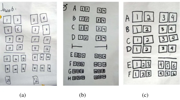
second class is different. So we cannot do skip counting or multiply it easily. The system that may occur:
Students may make a system of the seat with only consider the number of line
32
Students may differentiate the system within first class and second class. For
the first class they may only number it from 1 to 16 but for the second class they may only use the number of line which is 1 to 22.
Students may not differentiate the first and second class and start to number/
count the line from the first row till 26th rows.
Students may also consider right and left seat (separate the group of seats as
left and right group) and start to number the row. So they will make a system based on row and left right group.
Maybe students symbolize the left and right as A and B
Students may consider row and column. So they will number the seat as
combination of the row and column like row 1 and column 2 as (1.2) or maybe just by telling “it is in the 1st row and 2nd column”
Students may symbolize the row with number and column with alphabet (A to
F) and differentiate the first class.
Students may not differentiate the first and second class and symbolize the row
as number 1 to 26, and column as A to F. While for the first class there will be only column A to D.
Students may directly come up with the idea numbering the seat with “12A”
(combine number and alphabet) because they ever ride the airplane.
Main Issue: the students may or may not find the good system. all of the students’ answer is bring to the class discussion. The discussion is emphasized on why the systems is good system and why not. Here the good systems that may occur: Combining number and alphabet like 12A
33 Combining number and number like 3.4
Numbering it as 124 which mean first column seat number 24 (24th row). We expect that students may answer that a system is considered as a good
system if we can easily find a location of an object using that system and we can easily tell that location to other without any ambiguous meaning.
4.2 Activity 2: Seat map of a cinema (How a system works?) Learning Goal:
Through this activity I hope that:
Students can understand how a system work
Students aware of another coordinate systems
Students aware of row/line and column
Students aware that to locate a thing precisely need at least two variables
(line/row and column). It is not enough if only consider one variable, for example just consider the row.
Starting point: There is no specific skill that needed to do this activity. Mathematical activity:
Discussing the cinema’s ticket
Image Source:
34
Should be noted, the discussion is emphasized on the meaning of the number and alphabet on the ticket especially the seat number. Teacher may ask what students see in the ticket and ask more about the seat number. “so what the number of the seat?” can you explain what is the meaning of F and 9? F and 10?”
The students will be asked to solve this following problem.
Students are given the map of the seats in a cinema. Teacher starts to tell a story about her friend namely Dona who is going to work on a cinema. Before she starts to work, her boss gives her the seat map of the theater and asks her to study and understand it. What can you tell about the map? Can you help her to understand the map especially about the number of the seats so if there is a person who ask her help to find his/her seat, they can tell him/her easily and precisely.
35 Discuss with your group!
What will you tell to my friend about the theater? What is important to be
known by her? What can you tell about the seat map?
What is the different between this seat map and the seat map of a plane that we
made in the previous meeting?
Can you make another different system to number the seat in this theater? A prediction of students’ responses
Students may answer they see: the name of the cinema, movie’s title, date,
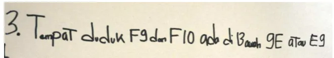
time, price, number of the theater (4), and the seat number (F9 and F10 or F9 and F10).
For the next question,
Students may respond that F9 means it is seat number F9. (In this case teacher
can ask how we can find it? do the number is written on the seat?) 9 and 10 (because the seat numbers must be different)
9F and 10F (because he/she still thinks about the seat number on a plane) 9
or 10 is the row and F is the column.
Students may answer it is row F and seat number 9; row F and 9th column; or
row 9 and column F
For the F10 students may answer similar like F9 or maybe there some students who will answer “it is next to F9”.
Prediction of students’ answer/respond of working group activity
Students may start to describe the Theater. They may tell that the screen is in
36
column (some are only 19). There is also staircase in the exit and there are two places for the wheelchairs.
Students may also come up with the detail explanation about the seats/ chairs.
They may answer that the seats are arranged in row and columns. There are 20 columns (some only 19) and 13 rows. The seats are numbered with alphabet and number. The alphabet represents the row and number represents the column. It starts from the left to right.
The difference between this seat map with the previous one is they have the
different number of row and column. In the plane, the alphabet represents the column and the number represents the column. While in this system, it is reversed.
Students may make another system by reverse the alphabet and number. Some
students may use only number or alphabet to represent the row and column etcetera.
4.3 Activity 3: Sunken Ship 1 (Make a System to locate a sunken ship) Learning Goal:
Students can make a system to locate a thing in a plane from a certain point
without any help of column and row or grid
Students aware of the different types of coordinate system
Students aware of the use of the coordinate system to locate an object in a
plane
Students understand the idea that a point is unique
Students understand the idea that in making a system to locate a point at least
37 Students aware of the origin point
Starting point:
Students already know about the direction like left-right and familiar with
compass direction (north, east, south, and west, etc.) Students know about scale
Students understand what a good system for locating an object is (first lesson).
Mathematical activity:
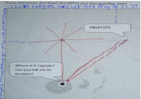
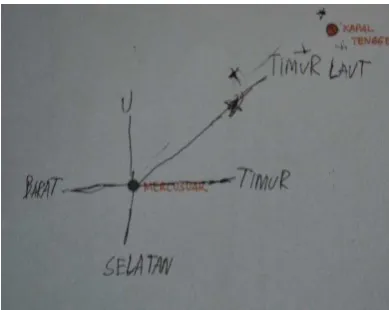
In this activity students are given this problem:
38
How the captain supposed to tell/report the location of the sunken ship to the general? Remember, giving a report to the general must be precise and not ambiguous (lead to another or false location). (Discuss it with your group!) Students’ answer:
Students may locate the ship by considering only one aspect.
Students may answer using the north, east, south west direction.
They also may use right and left direction.
Or they may thing about using clock as location like the position of two o’clock (student may ask considering the different point of view of the one
that tell the information and the one that received it)
They may use measurement. So the measure the distance of the sunken ship to
the lighthouse.
They may come up with the idea of angle.
Students may locate the ship by combining two aspects or two measurements. Students may locate the ship considering the angle and its distance from the
lighthouse
Instead of using the light house as the origin point, the students may use the
corner of the map as origin point.
Students may locate the ship by measure its distance to the lighthouse and to
the one side of the map.
39
the location of the sunken ship is 10 km from the lighthouse, then it will not clear whether it is 10 km to the right, left, north or etcetera. So it is important that the system is made is a good system which have been learnt and discuss in the first meeting.
4.4 Activity 4: Playing in the Paddies fields (where is your origin point?) Learning Goal:
Students can tell a location of a place or an object precisely
Students understand that each point is unique.
Students understand about the origin point (they will not start to count/ name
the first line as 1 but the second one and they have to consider from which view they see the map)
Students are aware of vertical and horizontal grid lines and intersection of
grids lines
Students aware that to locate a thing precisely need at least two
variables/parameters (vertical and horizontal axis/ grid lines). It is not enough if only consider one variable, for example just consider the vertical lines. Students know the positive coordinate system.
Starting point:
Orientation, the students understand the direction like left-right, up-down,
above-below.
Students understand the term vertical and horizontal
40 Mathematical activity:
Children are given a map of paddies fields. These fields are specially built/ made for the recreational purpose. So that children from the city can experience the village environment.
Problem: Yesterday, class 6 of an elementary school “Pusri” went to the fields. They observed and helped the farmer to work on the field. In the break time, they played and walked around the fields. However, when a student namely “Dina”
reached her home, she realizes that she lost her watch. She remembers that she take it off and put it in her pocket when she was playing in the fields. She is sure that it is dropped in the fields. She calls a farmer leader Mr. “Toni” for asking his
help to find her watch. Dina : “Hello.. “ Mr. Toni : yes hello
Dina : may I speak to Mr. Toni?
Mr. : yes I am Toni. With whom am i speak?
41 Map:
A list of students’ answer
Students might draw the map as grids (modeling it as grids)
Different group may look at the map from different views. So they will have
different corner to start with. This can cause the different location.
right-42
below corner as starting or origin then they will end up in the position of red dot in the picture b.
Students might start to count the first road from the main road/boarder. Students might not count the boarder. They skipped “0” zero.
Students might count 1 to the right 2 up.
Or maybe they will count 1 to the left and 2 up
The possible position of the watch that may occur can be seen as follow. The location is represented by red dot. These positions are resulted from the different point of view and origins
For the name of first, second road and so on, some students may start to count the corner as the first road. But other students may count the corner as zero which will give different locations.
43
system to locate an object, we need the same origin so they can locate a thing precisely and uniquely.
After students agree about the origin, then the teacher can continue the discussion by proposing a question like: so where is the location of the watch? How do you supposed to tell Mr. Toni? In the intersection of which lines is it?
Those questions is aimed to help the student understand about the more formal system like coordinate (positive) which can help us to tell the location of an object easily and accurately/ efficiently. So rather than say walked straight, enter the first road and met the second road, we can just say that it is in the intersection of second and first road. We do not expect that the students already come up with the system like (1,2).
So the teacher can proposed the grids which represent the fields and roads and say that “at first Dina stood her (corner). And this (point the first road) should be the first road, second and so on” Like in the image below.
44
second and first road. If the students say that it is the intersection of first and second road because she walked straight first and meet the first road then enter it. Then the teacher can ask “How if Dina stands in the corner and walked to the
right and meet the second road then enter it and stop when she meets the first road?” These different answers can be discussed and we expected that they (students) make an agreement on it.
Later, the teacher poses several questions like guessing the location (similar to Dina’s clue). This is done in order to give a chance for the students to
practice their knowledge and to do a brief check whether the students understand about the concept that they just learnt.
In the end of the lesson, teacher can ask “How if the location of the watch
is in here (outside the grids: right, up, left, and down sides)”.
4.5 Activity 5: Sunken ship 2 (Locate the ships with the help of grids) Learning Goal:
Students can tell a location of a place or an object precisely
Students can understand that although the point is not in the intersection of
vertical and horizontal axis, it still can be located precisely (for example, (1, ½))
Students can locate a point which involves negative number/ coordinate
Starting point:
Students can produce the grid which is labeled by (0), 1, 2 and so on (exclude
the boarder/ 1st line) for both horizontal and vertical lines (product from the paddies field activity).
45
Students understand negative number and fraction
Students know how to measure a length
Mathematical activity:
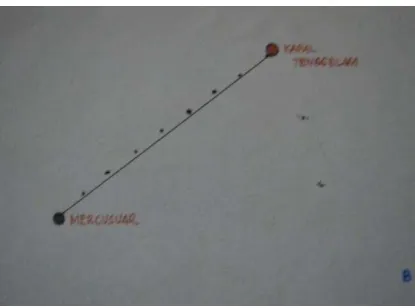
This activity is continuation of the activity 3 (use the same context and problem). The difference is in this activity, the map is supported by grid lines. Problem:
Do you still remember the story of sunken ship in the previous meeting? Following map is the satellite image of the sea, lighthouse and ships.
Can you locate the sunken ship? How do you locate it?
Can you locate the SAR teams from the lighthouse? (the light house as the
origin)
What did you find after locating the SAR teams?
Students’ answer
Instead to see the lighthouse as origin point, students may label the gridlines as
they did in the previous activity (labeling it from 0 to the positive number). If this happen then the teacher can ask, how if I used the location of the lighthouse as the origin?
46
Students may use the term vertical and horizontal lines to differentiate the axis
For the location of the point which is not exact in the line intersection. The
students may use ruler to measure it distance from the origin point.
Students may count the squares in order to locate the point which is looks like
in the square rather than measure its distance.
For the negative location, the students may use 1 to the left (so using the
positive number but in left direction rather than symbolize it as negative number)
Students may recognize the negative coordinate because they learnt about
number line
Students may recognize that there is negative coordinate and coordinate
involves fraction.
Main Issue: In this activity teacher help the students to understand the coordinate location that involves the negative number and fraction. Students make an agreement of how they will notate the location.
After the students understand about the negative and fraction coordinate, the teacher start to bring the grid into more formal form which is Cartesian coordinate system. Teacher draws the main axis and symbolizes the lighthouse as “0”, and then the teacher asks the students to relocate the sunken ship and SAR
teams in the given Cartesian coordinate system.