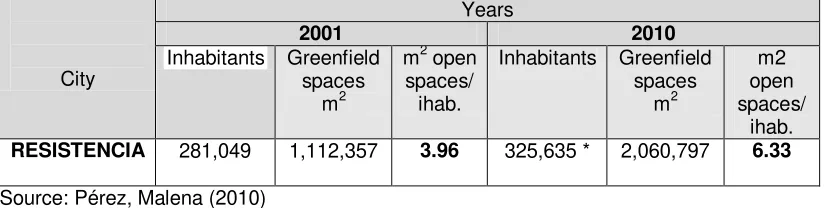
25
GREATER RESISTENCIA STUDY CASE: GREENFIELD AND INCREASED
DENSIFICATION
Malena Perez
–
Valeria Schneider
[email protected]
- [email protected]
Urban and Regional Planning Institute (IPUR)
Universidad Nacional del Nordeste-(UNNE)
Av. Las Heras 727. (3500) Resistencia- (Chaco)- Argentina
ABSTRACT.
This paper focuses on one of the relevant issues of the phenomena of urban
expansion and densification, i.e. the lack of planning of public greenfields. At the regional
level, since 2001, Resistencia City Council has been promoting a growth in height by
increasing built-up areas in central districts that have complete infrastructure, through the
implementation of the Ordinance 5403/01 -
high density.
On the other hand, in the last 10
years the population growth of the city (16%) has been followed by an increase in the
supply of open space per inhabitant (85%). However, this increase is not reflected in the
inner city areas, where the higher population density is located. This paper aims to analyze
and relate the results arising, so far, from the densification of central areas and its
relationship with the availability of open space in central districts of Greater Resistencia
City.
26
BACKGROUND
This work is linked to two projects in the Urban and Regional Planning Institute of the
Faculty of Urban Architecture: Observatory for the New Sustainable Policies. These are
‘
The Greater Corrientes and Greater Resistencia Study Case
’
, and
‘The
Metropolitan
Studies Workshop
’
to conform with the Universidad Nacional del Litoral (Argentina) and the
Universidad Mayor de San Andrés (La Paz, Bolivia). Approved on 03/20/2009 by
Resolution of the Secretaría de Políticas Urbanas of Ministerio de Educación de la Nación
no. 249/SPU.
The processes of expansion and urban densification
While the phenomenon of urban sprawl afflicts developed and underdeveloped cities, there
is no agreement about it between planners and policy makers. The basic dimensions of the
policy debate on the expansion of cities are certainly not new. The age-old question
underlying this debate is still whether expansion should be resisted, accepted, or
welcomed, considering that really successful experiences are hard to find.
As Angel et al. (2005, p. 3) made clear for the World Bank of 90 cities, that belong to
developed and underdeveloped economies, concluded that the densities in developing
country cities were found to be some three times higher than densities in cities in
industrialized countries, and that densities in all regions were found to be decreasing over
time. If average densities continue to decline at the annual rate of 1.7%
⎯
as they have
during the past decade
⎯
the built-up area of developing country cities will increase from
200,000 km
2in 2000 to more than 600,000 km
2while their population doubled.
27
environments, cutting off essential greenfield corridors that ensure the biodiversity of the
ecosystem. Peripheral locations imply higher requirements for cars travel, and increased
urban costs, regarding the supply of services and infrastructure. However, these places
offer people a better quality of life because of their proximity to nature, whether in private
backyards or surrounding parks, and the increased availability of private space with lower
real estate costs.
The compact model is characterized by buildings in height, of medium to high-density,
concentrated in a greatly compacted built-up core. This model can be considered
environmentally sustainable, since it reduces car travel, energy consumption and the costs
urban services and infrastructure.Despite this, the low availability of land increases real
estate costs, reducing living space and diminishing quality of life. Given that with the
compact model, a decreased quality of city life and a lacking of private space is on offer,
then the supply of greenfields should be increased. It is necessary to promote a greater
"permeability" of the urban area, allowing
nature to be ‘
introduce
d’
in the city. Thus,
increasing access of citizens to greenfield spaces, promotes recreational, social and sports
activities, and by considering the
green ‘system’,
through its components, allows access to
nature, linking it with both urban activities and suburban systems.
Greenfield spaces and urban planning
At present, as it is being defined by the Research Institute in China
1; at the level of urban
design, within cities, the natural and social ecosystem may not be organically integrated
into the shape of urban space. This may contribute to an ecologically disorderly urban
landscape and a chaotic environment. Greenfield spaces are an essential part of
sustainable urban planning. As has been highlighted in previous research, those free,
public spaces, associated with a strong presence of vegetation, are key elements of urban
intervention, which can supply order to the territory, providing environmental and social
benefits to the population.
Design of recreational greenfield space in the urban area must take into account
key-factors, such as standards of square metre/inhabitant, density of population, cultural
features, social facilities, environmental features, and parameters such as diversity,
connectivity and associativity. In a city, it is not enough to meet the amount of 10 square
1The "study case of techniques and ecological methods for the urban design" The Institute For Urban
28
metre/inhabitant as suggested by the World Health Organization (WHO); typologies of
open space and its distribution largely determine the quality of the urban landscape.
Therefore, several, small open spaces can provide great psychosocial benefits and fewer
large, remote Greenfield, suburban parks, also bring significant psychosocial benefits. The
ideal greenfield systems are a balanced combination of green zones of different sizes and
uses that complement each other. (Falcon, 2007)
Quality of life and greenfield space
According to Velázquez (2008), key issues of the natural environment that must be
considered are the elements that benefit and frequently affect and influence the quality of
life of the population. From a quality of life perspective, there are aspects of
the ‘
natural
’
environment which must be considered as part of the basic needs of the population. It is
also essential in quality of life population assessment that key factors of the natural
environment where population lives are included, such as education, health, housing, etc.
The
‘
quality of life measurement
’
is also related to the goal of becoming a basic tool that
includes the implication of policies and strategies for improving the quality of life of citizens
(Velázquez, 2008).
OBJECTIVES
-To analyze the situation arising in relation to the recently approved legislation that allows
intensification of central districts of Greater Resistencia
-To confront that regulation with the offer/availability of greenfield spaces in that city.
METHODOLOGY
The chosen methodology was suggested by the United Nations-Habitat to generate urban
observatories, ensuring that information obtained led to the determination of key indicators
that will be useful for building an urban management policy framework.
The work has grown in 2 research stages:
1. Cognitive-exploratory: survey of data relating to the study case, main uses by block,
building typology, estimated population density.
-Compilation of cadastral data, secondary information produced by researchers from the
Institute of Urban and Regional Planning
–
FAU-UNNE and technicians of the Municipality of
Resistencia.
29
2. Analytical: processing, systematization and analysis of relevant information on
key-indicators. Graphics and elaboration of tables. Analysis and conclusions.
DISCUSSION RESULTS
Urban phenomenon in Greater Resistencia
Recent decades have brought enormous change to human settlements around the world.
The Greater Resistencia Metropolitan Area (GRMA) of Chaco is no exception to this
phenomenon; its process of urban growth has been adding surrounding municipalities to
the original core, expanding rapidly into territories of flood prone vulnerability with high
environmental value, dominated by wetlands and associated ecosystems (Schneider,
1999). The city is situated on the western bank of the Parana river, opposite the city of
Corrientes, in the northeast of Argentina. This urban conglomerate includes Resistencia
and satellite cities, such as Barranqueras, Puerto Vilelas and Fontana, forming the Greater
Resistencia Metropolitan Area (GRMA).
The city is located in a flood plain, surrounded by protection walls known as an
embankment, forming polder systems, which limit the possibilities for growth. See Figure 1.
As such, the GRMA faces several challenges: The GRMA must prepare itself to
accommodate growth of 6,799 inhabitants/year according to The National Statistic and
Census Institute (INDEC). If the city actually continued to grow at this rate, Resistencia city
would need to incorporate 1,180 new dwellings per year and a minimum of 30 net hectares
of potential development land. As a result, local government needs to find policies that
privilege densification of safer central areas that have complete infrastructure (PDER,
2006).
30
typology, 30 buildings of perimeter free (detached) and 15 buildings semi-free perimeter
(semi-detached), resulting in 302 buildings on average (up to 4 levels) in the middle density
zone.
Figure 1: Greater Resistencia Metropolitan Area with enbankment systems. Source:
Resistencia City Council Strategic Plan (PDER), 2006.
Greenfield spaces in Greater Resistencia
31
* Estimated by the Resistencia City Council according to population projections.
32
33
In summary, the current open spaces in the Greater Resistencia built up area are
insufficient; this situation will exacerbate and there are few opportunities to increase the
availability of greenfield in state lands, accessible to all citizens. On the other hand, there
are several natural areas, part of the wetland systems, protected by regulation for flood
prone areas which it is possible to add to public open spaces and which can be used for
recreational purposes.
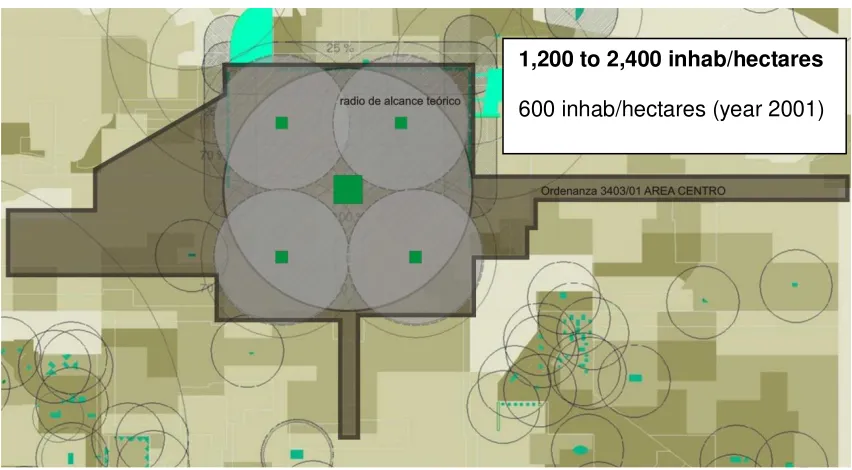
Open space and densification in the city centre of Greater Resistencia.
As shown in Plan 1, the amount of green space in the city centre area, covering 100% of
the population demand in the year 2001, whereas an average of 600 people per. / has.
Figure 3. "Typologies of open spaces within city centre of Greater Resistencia, distribution
and ratio of influence" Source: Pérez. 2010.
If the Ordinance 5403/01 (high density) objectives are accomplished, which attempt to fill
the built up centre up to 2400 inhabitants/hectares and if it is considered that the WHO
1,200 to 2,400 inhab/hectares
34
suggestion is 10 square metres/inhab., this would mean a demand of 24,000 m
2of
greenfield space per hectare, approximately two and half squares for each urban block.
Considering the Ministry of Social Welfare suggestions in relation to the central squares
(1.5 square metre/inhab.), half of open spaces per each hectare of the city centre area
would be needed. Therefore, for 256 blocks covering the city centre built up zone, 128
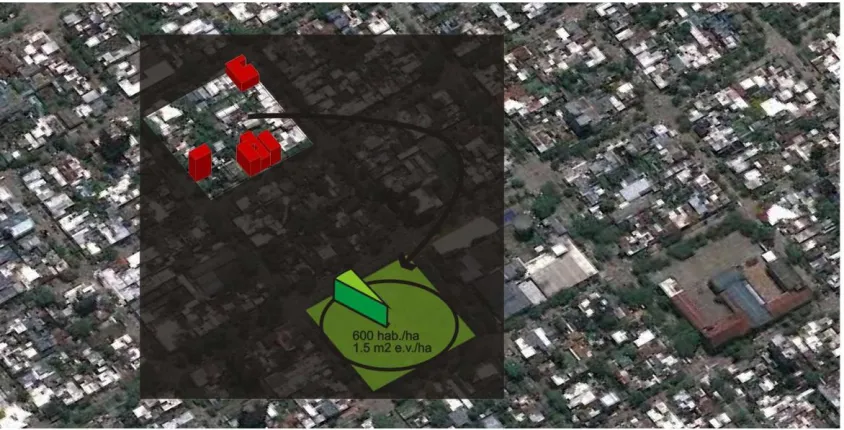
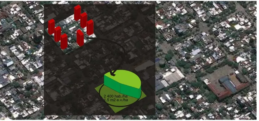
hectares of open space would be needed at the neighborhood level. See Figure 4 and 5.
35
Figure 5. "Potential relationship of population density, according with Ordinance
5403/01/square meter of greenfield spaces in the city centre
–
STUDY CASE BLOCK 181"
Source: self- elaboration.
FINAL REFLECTIONS
In urban models committed to densification of the built up zone, it is essential to ensure the
availability of greenfield space as one of the key issues that will sustain the model. The
typologic study of open spaces in Greater Resistencia highlights the important surface of
urban wetlands, about 48,908,802
square metres/inhabitants which remain to be formally
included as recreational parks and also form a significant biotic reserve (Pérez, 2010). It is
also important to point out that this reserve area could serve a city of nearly 5,000,000
inhabitants, taking into account the 10 square metre/inhabitant recommendation suggested
by WHO.
36
typologies are linked through greenbelt corridors related to road traffic; and associated
public headquarters, specific sidewalks and other components can make a contribution to
building open spaces associated with cultural identity. The future challenge for planning is
not only to find the way to contain urban growth but also to balance human, financial and
technical resources to ensure issues such social, economic and environmental
requirements are being addressed.
Techniques of urban growth management can be defined as a set of policies, in all their
varied forms, used by the government as a set of regulatory powers in a comprehensive,
rational and co-ordinated manner to meet public objectives for balancing economic growth
with the aim of protecting and preserving natural and manmade systems. It involves an
ideological commitment on the part of the government to create and strengthen institutional
mechanisms for effectively using tax, expenditure and regulatory powers to systematically
influence a community's spatial distribution of activities." (DeGrove and Metzger, 1993)
On the other hand, it is known that one of the reasons for government intervention is due to
the presence of market failure. Market forces do not produce all the conditions necessary
to sustain life, especially in cities; the State, therefore, has to intervene particularly with the
provision of infrastructure and services and ensuring that some balance is reached
between social costs and private benefits of urban enterprise. (Devas and Rakodi, 1993).
Urban growth techniques started when government decided to intervene in economic
markets to protect the poorest. For all these reasons, the Government should intervene to
protect the most vulnerable population when the market fails, making available those things
that the market threatens, so contributing to the general wellbeing of the population
(Schneider, 1999).
One of the most common market failures is the "Real Estate Market".
In Resistencia, where the Ordinance allows densification increased, land prone prices in
central districts have been raised rapidly since 2001, threatening the natural environment
and quality of life whilst also affecting the supply of greenfield spaces, which, as has been
noted before, are also essential components of social welfare.
37
resolution 1111/98 of Provincial Water Management, is another way of providing the 10
square meter / hectares suggested by World Health Organization. Finally, we wish to
express the following concerns: We believe that it is necessary to promote within the built
up zone of GRMA, have linkage of different open spaces composed of lagoons which are
part of wetlands and the surrounding Rio Negro Valley, promote accessibility to the Ramsar
site, and combine different scales of greenfield typologies with urban densities, to balance
the supply of open space throughout the city.
BIBLIOGRAPHY
Angel, S., Sheppard, C. et al. (2005).
The Dynamics of Global Urban Expansion.
Transport and Urban Department
. World Bank. Washington D.C..p.200.
Bettini, V.(1998).
Urban ecology key elements
. Ed Trotta. Serie Medio Ambiente. Madrid.
Borja J.(2003).
The conquered city
. Ed. Alianza Ensayo. Madrid.
DeGrove, J. and Metzger, P. (1993).
Growth Management and the Integrated Roles of
State, Regional, and Local Governments.Growth Management
. The Planning
Challenge of the 1990s.USA. Pp.3-17.
Falcón, A. (2007).
Greenfields for sustainable city. Planning project, maintenance and
management.
, Ed. GG. Barcelona.
Hough, M.(1998).
Nature and City
. Urban Planning and Ecologic Process. Ed
G.G.,Barcelona. 1998.
Pérez, M.(2010).
Greenfield systems in the city of Resistencia. Characteristics and
dimensions
. Fourth Seminars of Research, Teaching, Extension, Management of
Faculty of Architecture and Urbanism (UNNE)
–
Resistencia.
Resistencia City Council (1978).
Land Use and Zoning Code of Resistencia city
.
Resistencia City Council (2005).
Resistencia Strategic Development Plan Report.-
Publicación
. CD-Rom.
Resistencia City Council. web site. http://www.mr.gov.ar.
Schneider, V., Kidd, S. (1999).
Urban Growth Management
. Civic Design Department,
University of Liverpool, UK.p. 97.
Scornik, C.O., Pérez, M.et al. (2010).
Urban observatories in Greater Resistencia
38