Kingdom in the Central Java, Indonesia
Sari Bahagiarti Kusumayudha(&), Helmy Murwanto, Sutarto, and Siti Umiyatun Choiriyah
Universitas Pembangunan Nasional Veteran Yogyakarta, Yogyakarta, Indonesia [email protected]
Abstract. In the area of Central Java and Yogyakarta there are several volca-noes namely Sindoro volcano, Sumbing volcano, Slamet volcano, Ungaran volcano, Merbabu volcano, and Merapi volcano. Among the volcanoes, Merapi volcano is the most active, generating lavaflows, pyroclasticflows, glowing clouds, and lahar. On the other hand, during the 7th to 10th century in this region had been existed an ancient monarchy, known as the Mataram Kingdom. Its glory at that time was marked by many ancient heritages especially in the form of temples. There are many monumental, beautiful, and majestic archae-ological relics, located on the plains, slopes, even near the summit of Merapi volcano, Sumbing volcano, Sindoro volcano, Dieng mountains, and Ungaran volcano.
In the 11th century the history of Mataram Kingdom was not recorded any-more, suspected that the kingdom declined, and the cultural center of excellence transferred to East Java. Up to now, the cause of the collapse of Mataram Kingdom is still a mystery. Some historians suspect as a result of a great war, and some others thought as the impact of volcanic disaster. Nevertheless, the fall of Mataram Kingdom still being an enigma.
At the southern slopes of Merapi volcano, there are some ancient buildings that buried by volcanic deposits. For example Kadisoka temple part of the building is still dotted sandstone, tuff, and pyroclastic sandstone, cobbles. Similarly, Sambisari, Kedulan, and Pustakasala temples, when discovered, they were sinked by sand, tuff, and fluvio-volcanic sediments. On the slopes of Sindoro volcano, there are also ancient sites, namely Liyangan was covered by pyroclasticflow, tuff, and lahar deposits. Thus it is possible that volcanic dis-asters have contributed to the decline of Mataram Kingdom.
Keywords: Volcanic disaster
Pyroclasticflow
Lahar
Ancient temples Mataram Kingdom
1 Introduction
In the Central Java and Yogyakarta Special Territory of Indonesia, during the 7th to 10th century, there was an independent state, namely the Mataram Kingdom. The past kingdom glory is marked by the existing of many ancient relics and buildings, two of which are internationally well-known, as Borobudur temple and Prambanan temple. Some beautiful and magnificent monumental archaeological remains have been found
©Springer Nature Switzerland AG 2019
in the study area. The beauty and splendor of the ancient heritage illustrates the taste of architectural artworks of noble, in the form of Buddhist and Shiwa Hinduist temples. The temples are generally scattered on the plains, the feet slopes, the central slopes, the upper slopes, and some even on the summit of the mountains. At the time of its discovery, several temples were heavily damaged or buried by soil and rocks as deep as 2 to 6 m.
There were no archaeological relic discoveries after the 10th century, indicating that in the Central Java did not exist any governmental or state. This was a marker of the sudden disappearance of the ancient Mataram Kingdom from historical records. It was subsequently replaced by the emergence of various kingdoms in the eastern Java, starting from the kingdoms of Singosari, Kediri, Jenggala, to Majapahit, from the 12th century to the 14th century. The kingdom history seemed to be allegedly migrated to the East Java.
According to historians, the movement of the central government from the Central to the East Java was driven by political, cultural and religious aspects. In the matter of facts, some ancient relics were found in a collapsed condition, or buried by sediments of natural works. Therefore, in the framework of providing historical corrections and information, geological-based studies was done to unravel the enigma of the Mataram decline and its relationship with natural disaster in the Central Java and Yogyakarta Special Territory.
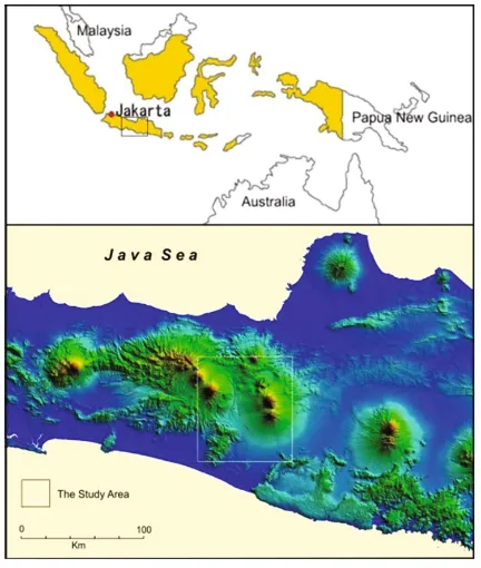
Objectives of this study are to mapping and analyzing the geological disaster tracks and records such as volcanic eruption, lava, and ash deposits around ancient archae-ological sites that suspected of contributing to the damage the temples. The location of the study area is shown in Fig.1.
2 Literature Reviews
2.1 History of the Mataram Kingdom
The Mataram Kingdom in the Central Java, established from the 7th to the 10th century, was ruled by kings from the Sanjaya dynasty and the Syailendra dynasty. It is written in the Mantyasih inscription (907 AD), that the Ancient Mataram Kingdom authority was covering Central Java and Yogyakarta territories. But in the late 10th century the royal capital moved to the East Java, and the cultural center of Central Java seemed to shift to East Java, marked by the emergence of Medang, Kahuripan, Kediri, Jenggala, Singosari, and Majapahit kingdoms. The history then returned to the Central Java after Majapahit Kingdom collapsed, entering the Islamic era, starting from Demak Kingdom, Pajang Kingdom, and Islamic Mataram Kingdom founded by Panembahan Senopati (Kusumayudha2006a,b).
royal center being moved to East Java. In another inscription it is written that the transfer of government occurred in 930 AD, during the reign of the last king of the Mataram Kingdom, Mpu Sindok (928–947 AD). Mpu Sindok subsequently established Medang Kingdom where the center of his government was initially located in the upstream of River Brantas (Poesponegoro and Notosusanto2008).
According to Van Bemmelen (1949), Neuman van Padang (1951) in Kusumayudha (2006a,b) and MacDonald (1972), Merapi volcano erupted catastrophically in 1006. This eruption resulted in a total paralysis of the economy, farmland severely damaged, and volcanic deposits 6 meters thick covering the ground. It was illustrated that the people and the royal family were destroyed by the laharfloods and buried by volcanic ash.
Nevertheless, this hypothesis was opposed by some volcanologists. Based on inscription Pucangan, during the reign of Dharmawangsa (1016–1017 AD), the king-dom suffered a major catastrophe causing the capital to be destroyed, many deaths, and economical paralyzed. In the event, the cousin of the king, named Airlangga was able to escape to the Southern Mountains. Airlangga then develop the Singosari Kingdom. This happening is known as theMaha Pralaya(Zen2006). With regard to the greatest of praws, related to the decline of the Mataram Kingdom, there are still two different opinions, whether due enemy attacks from the Wura-wari Kingdom (Sri Wijaya) or by the eruption of Merapi volcano (Kusumayudha2006a,b).
2.2 Volcanic Disaster
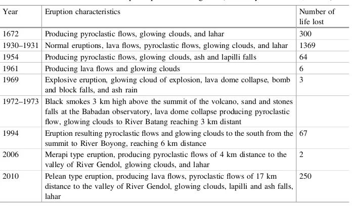
Kusumadinata (1979) recorded a series of Merapi eruptions proving that the volcano has been very often erupted. The volcanic activity rest time is usually 5 years. During the eruption break, Merapi will slowly build a lava dome that will be destroyed and ruptured in the next eruption period. In the valley of River Sileng, Borobudur area, there is found such volcanic ash as thick as 2 m. From the results of radio-dating testing, the sediment was estimated to be approximately 600–700 years old. Some evidences show that at that time there was such a major eruption of Merapi volcano. Merapi eruptions which claimed many lives, recorded in history are as follows (Table1):
The prehistoric major eruptions of Merapi were never known for certain by anyone. Scientists can only try to trace and reconstruct these occurrences with geological, vol-canological, historical, archaeological, cultural, even metaphysical approaches. For human life, actually the more important thing is not about when Merapi erupted exactly, but rather how the impact of the eruption to human life (Kusumayudha2006a,b).
Borobudur temple has a different historical background. Murwanto et al. (2004) found evidences related to the existence of a lake around the temple at that time. According to Van Bemmelen (1949), the ancient Borobudur Lake occurred as a result of a major eruption of Merapi volcano in 1006 AD. This devastating eruption caused apart of the peak of Merapi to collapse to the southwest direction, stemming theflow of River Progo, forming a large lake in the area of South Kedu. The Borobudur great lake as a hollow between the mountains (intermontains basin) was gradually deterred by tectonic and sedimentation processes. In the VIII century. Borobudur temple was built on a small hill surrounded by a lake during the reign of King Smaratungga of the Syailendra dynasty.
Table 1. The records of Merapi eruptions causing lost (Kusumayudha2013a,2013b)
Year Eruption characteristics Number of
life lost 1672 Producing pyroclasticflows, glowing clouds, and lahar 300 1930–1931 Normal eruptions, lavaflows, pyroclasticflows, glowing clouds, and lahar 1369 1954 Producing pyroclasticflows, glowing clouds, ash and lapilli falls 64
1961 Producing lavaflows and glowing clouds 6
1969 Explosive eruption, glowing cloud of explosion, lava dome collapse, bomb and block falls, and ash rain
3
1972–1973 Black smokes 3 km high above the summit of the volcano, sand and stones falls at the Babadan observatory, lava dome collapse producing pyroclastic flow, glowing clouds to River Batang reaching 3 km distant
1994 Eruption resulting pyroclasticflows and glowing clouds to the south from the summit to River Boyong, reaching 6 km distance
67
2006 Merapi type eruption, producing pyroclasticflows of 4 km distance to the valley of River Gendol, glowing clouds, and lahar
2
2010 Pelean type eruption, producing lavaflows, pyroclasticflows of 17 km distance to the valley of River Gendol, glowing clouds, lapilli and ash falls, lahar
The activity of Merapi volcano has a major contribution to the environmental change of the lake and the mainland. The eruption materials gradually hoarded the Borobudur Lake, causing it to become shallow andfinally dry at the end of the XIII century. Merapi eruption materials not only dried the lake, but also damaged and buried Borobudur temple as those of other temples in the Central Java and Yogyakarta.
In addition to the primary hazards of pyroclastic flows, glowing clouds and vol-canic ash, the secondary threat of volcano that is no less dangerous is lahar. Lahar is a dense stream that occurs when the pyroclastic deposits in the upper slopes of the volcano mixes with rain water becoming saturated, then influenced by gravity to
flowing downstream through the river valleys as a heavy currents of mud and rocks (Kusumayudha 2013a, b). Lahar behaves enormous erosion, high destructiveness, capable of transporting very large materials, including boulders, trees, and buildings. Lahar of Merapi in 1930–1931 along with the primary eruption, has claimed of 1369 deaths (Kusumadinata1979)
3 Methods of Study
The research carried out with descriptive, comparative, and surveys methods that was complemented by geological phenomena mapping. The data used consist of secondary data and primary data. Secondary data includes various information from the existing studies. Primary data obtained through survey andfield mapping. Geological studies to be carried out include geomorphology, petrology, stratigraphy, sedimentology, geo-logical structure, and disaster analyses.
The stages to be carried out during the research were divided into three steps. Firstly, to collect secondary data consist of map showing the distribution of ancient relics, regional geological map, tectonic map, disaster map, aerial photography/satellite imagery, and historical research data ever undertaken by other researchers. Secondly, to analyse the geological map, tectonic map, and disaster map as well as remote sensing interpretation using aerial photography/satellite imagery against the spread of archae-ological sites, and the presence of gearchae-ological structures around the sites. Thirdly, to mapping geological details around the archaeological sites, including the dissemination of sediment produced by volcanic activity, either the primary activity of pyroclastic or the secondary activity of lahar.
4 Results and Discussion
4.1 Archeological Sites Discoveries
4.1.1 Temples on the Foot Slopes of Merapi
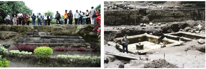
In the year 1966 Sambisari temple was found by a farmer. When discovered, it was buried by sediments of about 6 m thick. The sediments covering the temple comprise volcanic materials including sand, tuff, and stones with the grainsize of granule to boulder. As it is displayed on the bank of River Kuning, the deposits show various sedimentary structures such as imbrication and carpet tract, indicating that they are lahar deposit.
At another village namely Kadisoka, there is a small Hindu temple that most of the building still hidden by eruption deposits of Merapi volcano (Fig.3). In the embankment there are sedimentary structures which indicate that these materials are the interlayering of lahar,fluvial, pyroclastic falls, and glowing clouds deposits. According to Mulyaningsih (2006a, b), around the Kadisoka Temple, there is an evidence of 4 (four) sequences of Merapi deposit that buried the temple, each of which occurred in the different periods. The oldest eruption period happened about 1900 years ago, or in the II century.
Fig. 2. Distribution of temples and archaeological sites of Java (www.wikipedia.org/wiki/ Daftar_candi_di_Indonesia)
There is another temple called the Kedulan temple, has founded in the IX century. As that of Sambisari temple, it was covered by about 6 meters thick of volcanic materials. It consists of sand, granule, gravel, and boulders with tuff impurities. Based on the soil profile analyzed by Mulyaningsih (2006a, b), the deposits display an interlayering of lahar and pyroclastic fall sedimentation. In a different time and place, when the Islamic University of Indonesia (UII) would built a library building, there also was found a hidden temple which then given the name Pustakasala (Fig.3). The ruins of the ancient temple were covered by laharic and pyroclastic deposits of Merapi volcano as well.
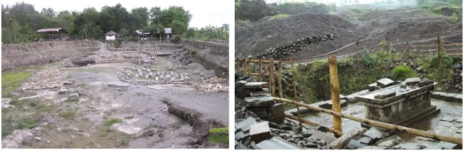
4.1.2 Sites on the Foot Slope of Sindoro Volcano
On the southwestern slopes of Sindoro volcano, Liyangan site was found by the sand miners (Fig.4). This site was buried by volcanic deposits as thick as more than 10 m. Based on thefindings of wood charcoal, the ash content at the sediment that buried the site, it can be concluded that the Liyangan Site is buried by eruption products of pyroclastic falls and pyroclasticflows.
4.2 Geology and Volcanism in the Central Java
The Java island tectonic setting is controlled by the subduction of the India–Australia plate beneath the Eurasia plate forming a series of active volcanoes stand in the middle part of the island (Fig.5). Despite there are plenty of active volcanoes, due to this tectonic setting, the Java Island is also subjected to earthquake very often. At the present time, the central Java area still affected by several geological disasters such as 2006 Yogyakarta earthquake, and 2010 Merapi eruption. In the study area, presently, volcano that still active is only Merapi, while Merbabu volcano, Sumbing volcano and Sindoro volcano are classified to be in post volcanism stage.
Merapi volcano, is one of the most active volcanoes in Indonesia. When it erupts, the volcano occasionally spews lava, glowing clouds, and pyroclastic materials out. Merapi always offers opportunities as well as threats to the life of the surrounding community. It is able to act as the source of prosperity and the source of the disaster as well. The magma chamber of Merapi is very shallow, it is supplied continuously by the partial melting of the India-Australia ocean plate that constantly moves to the North,
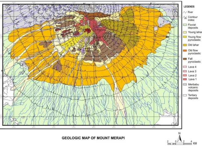
subducted under the of the Eurasia continental plate, making the volcano remains alive (Kusumayudha2013a,b). The distribution of Merapi eruptions deposits are displayed in the geological map of the volcano, as shown in Fig.6, while situation and condition related to Merapi activities are presented in Figs.7,8,9, and 10.
Fig. 5. The tectonic setting of the Java Island, in the convergence of India-Australia plate and Eurasia plate (www.earthobservatory.sg)
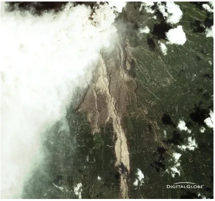
Fig. 7. Satellite image showing Merapi eruption and lavaflow. Acquisition date: November 11, 2010 (courtesy: DigitalGlobe)
5 Conclusions
Based on the above discussion, it can be concluded as follows:
1. Some temples in the Central Java and Yogyakarta were discovered in damage condition and/or buried by volcanic materials. They are Sambisari temple, Kadisoka temple, Kedulan temple, Pustakasala temple, and the archeological site of Liyangan. 2. Merapi volcano is one of the most active volcanoes of Indonesia, its eruption in 2006 and 2010 produced pyroclastic flows with a range of about 8 to 17 km distance, burying Kaliadem village of Cangkringan district and surrounding areas, and resulted in areas with a radius of 30 km covered by volcanic ash.
3. Referring to the data that many temples were buried by volcanic materials, it can be concluded that eruptions of volcanoes, especially Merapi volcano had taken part in the destruction of the glory of Mataram Kingdom in the Central Java and Yogyakarta.
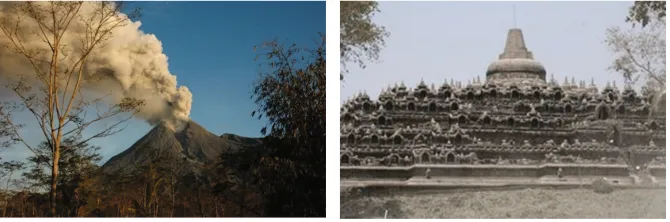
Fig. 10. After the eruption of 2010 (left), Borobudur temple covered by volcanic ash (right) (Doc: the Authors)
References
Kusumadinata, K.: Data Dasar Gunungapi Indonesia, Departemen Pertambangan dan Energi R.I (1979)
Kusumayudha, S.B.: Merapi: A Beautiful Bounty. Penerbit PT Citra Adi Parama, Yogyakarta (2013a)
Kusumayudha, S.B.: Gunungapi Aktif di Indonesia, edisi ke-2. Penerbit PT Citra Aji Parama, Yogyakarta (2013b)
Kusumayudha, S.B., Pratiknyo, P., Riyanto, A.: Hidrokimia airtanah lereng selatan Merapi pasca erupsi 2006. Jurnal Teknologi Mineral22(2), 144–153 (2009)
Kusumayudha, S.B.: Merapi: Sebuah Matarantai Sejarah, SKH “Kedaulatan Rakyat”, 22 February 2006 (2006a)
Kusumayudha, S.B., Murwanto, H.: Ancient lake track records, and its influence to modern hydrogeologic condition of the Borobudur National Park Area, Central Java, Indonesia. In: Pros 34th Congress of International Association of Hydrogeologists, Beijing (2006b) Mulyaningsih, S., Sampurno, S., Zaim, Y., Puradimaja, D.J., McGeehin, J., Bronto, S.: Very old
and young temple discoveries in Yogyakarta area: based on Volcano-tratigraphic study. In: Proceeding Volcano International Gathering, Volcano: Life, Prosperity and Harmony, Yogyakarta, 4–10 September 2006, pp. 102–114 (2006a)
Mulyaningsih, S., Sampurno, S., Zaim, Y., Puradimaja, D.J., Bronto, S.: Old building discoveries, parts of lost civilization in Yogyakarta areas: in geologic point of view. In: Proceeding Volcano International Gathering, Volcano: Life, Prosperity and Harmony, Yogyakarta, 4–10 September 2006, pp. 125–133 (2006b)
Poesponegoro, M.D., Notosusanto, N.: Sejarah Nasional Indonesia II, Edisi Pemutakhiran, Penerbit Balai Pustaka, xxii+536 p. (2008)
Van Bemmelen, R.W.: The Geology of Indonesia, Vol. IA, 732 p. Gov. Print. Office, The Hague Martinus Nijhoff (1949)