RAP
64
of
Bulletin
Biological
Assessment
Bali Marine Rapid Assessment
Program 2011
Edited by
Putu Liza Kusuma Mustika, I Made Jaya Ratha,
Saleh Purwanto
MARINE AND FISHERIES AFFAIRS BALI
SOUTH EAST ASIA CENTER FOR OCEAN RESEARCH AND MONITORING
WARMADEWA UNIVERSITY
CONSERVATION INTERNATIONAL INDONESIA
Bali Marine Rapid Assessment Program 2011
First English edition August 2012
Suggested citation:
Mustika, P. L., Ratha, I. M. J. & Purwanto, S. (eds) 2012. he 2011 Bali Marine Rapid Assessment (Second English edition
August 2012). RAP Bulletin of Biological Assessment 64. Bali Marine and Fisheries Afairs, South East Asia Center for Ocean
Research and Monitoring, Warmadewa University, Conservation International Indonesia, Denpasar. 137 pp.
Photographers:
Gerald R. Allen: Mark Erdmann:
Cover (left side), banner and contents of Chapter 3 Cover (right side), contents of Chapter 3, Figure 5.5
Lyndon DeVantier: Muh. Erdi Lazuardi:
Contents of Chapter 5 Banner of Chapter 4, banner of Chapter 5
I Made Jaya Ratha: Emre Turak:
Banner of Executive Summary, banner of Chapter 1, Contents of Chapter 5 banner and contents of Chapter 2, banner of Chapter 6
Cartographers:
Gerald R. Allen: Nur Hidayat:
Figure 3.19 Figures 1.1, 5.2, 6.1
I Made Jaya Ratha Ketut Sudiarta:
Figure 1.2 Figure 4.1
Emre Turak/Lyndon DeVantier: Figures 5.3, 5.4, 5.14
Translator:
Putu Liza Mustika (Chapters 2 and 4)
Layout: Kim Meek
Editors:
Putu Liza Mustika I Made Jaya Ratha Saleh Purwanto
English editor:
Philippa Blake
Conservation International is a private, non-proit organization exempt from federal income tax under section 501c(3) of the Internal Revenue Code.
ISBN: 978-1-934151-51-8 ©2012 Conservation International All rights reserved.
he designations of geographical entities in this publication, and the presentation of the material, do not imply the expression of any opinion whatsoever on the part of Conservation International or its supporting organizations concerning the legal status of any country, territory, or area, or of its authorities, or concerning the delimitation of its frontiers or boundaries.
Any opinions expressed in the RAP Bulletin of Biological Assessment Series are those of the writers and do not necessarily relect those of Conservation International or its co-publishers.
FOREWORD FROM THE GOVERNOR OF BALI
With the blessing of The Almighty, we hereby release the Bali Marine Rapid Assessment Program
report. The report contains the current status of all of Bali’s coastal and marine resources, and becomes
a key reference as the Bali Provincial Government plans for the management of our coast and sea, as
mandated by the Local Regulation 16/2009 on the 2009-2029 Bali Spatial Plan.
We take pride in these results that show that Bali’s marine resources remain exceptional. The report
presents comprehensive analyses of the island’s coral reef and reef ish. Currently recovering from climate
change impacts, Bali’s coral reef ecosystem is highly diverse. Similarly, the reef ish communities in Bali are
also highly diverse. Bali’s underwater beauty remains enigmatic; indeed this process has identiied several new
species. Bali’s coral reefs and other reef ecosystem organisms are important underwater economic resources,
for isheries, food security, and marine tourism. The discovery of several new ish species and one new coral
species reinforce the truly remarkable nature of Bali’s underwater treasures.
We must also pay particular attention to some serious matters, however, including the declining
populations of economically important ish species, and conlict over resource use. We must consult Law
27/2007 on the management of Coastal Zones and Small Islands and the Local Regulation 16/2009 on
the Bali Spatial Plan to control these problems and to minimise the emergence of new problems. These
regulations can guide the development of the Strategic Plan for the Management of Bali Coastal Zones, a
Management Plan and an Action Plan for Coastal Zones and Small Islands to foster sustainable isheries
and marine tourism in Bali. These efforts must be paired with strong commitment and collaboration from
partners in Government, the private sector and local communities in management actions such as surveillance
and law enforcement.
I hereby extend my gratitude to all who have actively been involved in the marine rapid assessment.
This report should be used for our marine and isheries resources. I hope all government agencies, private
sector partners and other stakeholders can use this information to guide development which is integrated
with nature.
I hope that this report inspires all stakeholders to build a better Bali for the future - an advanced,
safe, peaceful and prosperous Bali.
With thanks,
Om Shanti, Shanti, Shanti Om.
THE GOVERNOR OF BALI
iv Rapid Assessment Program
Foreword from the Governor of Bali (Indonesian version)
vi Rapid Assessment Program Foreword
In addition to being famous for its nature-based tradition and culture, Bali is also a renowned world-class tourist site. Located at the southwestern corner of the Coral Triangle, the waters of Bali are home to abundant marine life that supplies provisions for the local community and that has become a major tourism attraction.
However, managing Bali’s coastal and natural resources is a big challenge. Rapid coastal development has not yet been balanced by a proper long-term management plan. It is plausible, therefore, to question Bali’s long-term economic sustainability from this perspective.
he government, private sector and NGOs of Bali have all initiated various strategies for the island’s long-term development. he hard work and collaborative eforts of these parties resulted in the issuance of Local Regulation 16/2009 (on Bali spatial plan), which has become the guide for planning in Bali over the next 20 years. he establishment of Marine Protected Areas (MPAs) and an MPA network in Bali is but one strategy to translate the aforementioned Bali spatial plan.
Accordingly, through the Bali MPA Network program, Conservation International Indonesia (CII) aims to have the island’s marine and coastal resources managed efectively to protect ecosystem and socio-economic services for the local community and government. By aiming to develop an efectively managed MPA network for Bali that supports the government’s policies of ‘one island, one management’ and ‘Bali Clean and Green Province’, CII hopes to facilitate collaboration between the government and all related stakeholders. CII also hopes that, supported by capable and professional MPA managers, the Bali MPA Network will serve as the main support for resilient marine tourism on the island.
During a stakeholder workshop for the development of a Bali MPA network in June 2010, 25 locations were nominated as potential MPA sites. Scientiic input (bio-ecological and socio-economic) was deemed crucial to complement the MPA network design, prompting the Bali government and CII to conduct a comprehensive assessment of the island’s marine environment led by Bali’s Marine and Fisheries Agency. We hope that the results of the 2011 Marine Rapid Assessment Program will serve as a scientiic resource to guide the future Bali MPA Network team to work towards a Green Economy and Sustainable Tourism.
We thank the Bali government (the Marine and Fisheries Agency in particular) for its support and leadership in this assess-ment. We also thank the members of the Bali MRAP team: the Indonesian Ocean Institute, the Marine and Fisheries Agency, Warmadewa University, Udayana University, the Bali Nature and Conservation Agency (BKSDA), the Bali Diving Academy and others. It is our hope that this assessment and the following recommendations are useful for the decision makers and marine and coastal managers of Bali.
Denpasar, 24 October 2011
Ketut Sarjana Putra
Country Executive Director
Conservation International Indonesia
Foreword
Table of Contents
Foreword from the Governor of Bali ... iii
Foreword from the Governor of Bali (Indonesian version) ... iv
Foreword from the Head of Marine and Fisheries Affairs Bali ... v
Foreword from the Executive Director of Conservation International Indonesia ... vi
List of Figures ... viii
List of Plates ... ix
List of Tables ... xi
Participants ... xii
Executive Summary ... 1
Chapter 1 ... 8
Introduction Chapter 2 ... 11
Location Description I Made Jaya Ratha Chapter 3 ... 15
Reef Fishes of Bali, Indonesia Gerald R. Allen and Mark V. Erdmann Chapter 4 ... 69
The Status of Coral Reefs in Bali Muhammad Erdi Lazuardi, I Ketut Sudiarta, I Made Jaya Ratha, Eghbert Elvan Ampou, Suciadi Catur Nugroho and Putu Liza Mustika Chapter 5 ... 78
Biodiversity and Conservation Priorities of Reef-building Corals in Bali, Indonesia Emre Turak and Lyndon DeVantier Chapter 6 ... 131
Towards the Bali MPA Network
viii Rapid Assessment Program List of Figures
List of Figures
Figure 1.1. Priority sites to be developed as MPAs in Bali (the result of a stakeholder workshop in June 2010) ...10
Figure 1.2. The locations of MRAP in mainland Bali (2011) and Nusa Penida (2008) ...10
Figure 3.1. Satellite image of Secret Bay at Gilimanuk...25
Figure 4.1. Coral reef monitoring sites during the Bali Marine Rapid Assessment Program, 29 April–11 May 2011 ...71
Figure 4.2. Hard coral coverage at 5–7m and 10–14m on survey sites during the Bali Marine Rapid Assessment Program ...72
Figure 4.3. The hard coral coverage at survey sites during the Bali Marine Rapid Assessment Program, 29 April–11 May 2011 ...72
Figure 4.4. Average coverage of benthic substrates at survey sites during the Bali Marine Rapid Assessment Program, 29 April–11 May 2011 ...73
Figure 4.5. The average composition of total substrate coverage during the Bali Marine Rapid Assessment Program, 29 April–11 May 2011 ...73
Figure 4.6. The average composition of the ten genera that dominated hard corals found during the Bali Marine Rapid Assessment Program, 29 April–11 May 2011 ...73
Figure 4.7. The coral reef Mortality Indexes at survey sites during the Bali Marine Rapid Assessment Program, 29 April–11 May 2011 ...75
Figure 5.1. The Coral Triangle (dark red, after Veron et al. 2009). Bali is located on the SW corner. ...80
Figure 5.2. Candidate priority and non-priority sites identified during the Bali MPA workshop, June 2010 ...83
Figure 5.3. Approximate location of survey sites, Nusa Penida (17 sites, October 2008) and Bali (31 sites, April–May 2011). ...87
Figure 5.4. General areas of surveys conducted in regions of the Indonesian section of the Coral Triangle, including Bali and Nusa Penisa, Komodo, Banda Islands, Wakatobi, Derewan, Bunaken, Sangihe-Talaud, Halmahera, Raja Ampat, Teluk Cenderawasih and Fak-Fak/Kaimana ...87
Figure 5.5. Mean % cover (+ s.e.) of sessile benthos, Bali, April–May 2011 and Nusa Penida (October 2008) ...88
Figure 5.6. Scatterplot of levels of recent injury to reef-building corals in 85 stations, Bali ...92
Figure 5.7. Dendrogram illustrating results of cluster analysis of coral communities of 48 sites from Bali (B#) and Nusa Penida (N#.). ...95
Figure 5.8. Distribution of coral community types at 48 sites, Bali ...95
Figure 5.9. Mean cover of benthic attributes in 5 coral community types, Bali ...97
Figure 5.10. Dendrogram illustrating degree of similarity of different locations in terms of reef coral species presence ...103
Figure 5.11. Dendrogram illustrating results of cluster analysis of coral communities of 254 sites across six widespread regions of Indonesia: Bali (with geog. location of sites) ...103
Figure 5.12. Dendrogram illustrating results of cluster analysis of coral communities of 254 sites across six widespread regions of Indonesia ...104
Figure 5.13. Areas hosting main coral habitats and community types of Bali. Image courtesy of Google Earth ...104
Figure 5.14. Reefs of high conservation priority, Bali, indicated by red stars. ...107
List of Plates
Plate 2.1. Marine tourism provides income for fishers in Candidasa ...12
Plate 2.2. Tourist accommodation along the coast of Bunutan, Amed ...12
Plate 2.3. Local guidance for tourists not to disturb coral reefs in Pemuteran ...13
Plate 3.1. Example of Indian Ocean species at Bali: Acanthurus tristis, Amphiprion sebae, Chaetodon trifasciatus, Chromis opercularis, Leptojulis chrysotaenia, and Melichthys indicus ...21
Plate 3.2. Apogon lineomaculus. Known only from Bali and Komodo ...21
Plate 3.3. Examples of geminate species pairs: Chaetodon decussatus and C. vagabundus; Chromis dimidiata and C. margaritifer; Ctenochaetus cyanocheilus and C. truncatus ...21
Plate 3.4. An example of hybridization at Nusa Penida between Centropyge eibli and C. vroliki ...21
Plate 3.5. Examples of Bali species associated with areas of cool upwelling: Prionurus chrysurus, Springeratus xanthosoma, and Mola mola ...22
Plate 3.6. Parapercis bimacula...22
Plate 3.7. Manonichthys sp. ...22
Plate 3.8. Two new Pseudochromis from Bali and Nusa Penida ...22
Plate 3.9. Siphamia sp. ...22
Plate 3.10. Two new jawfishes (Opistognathidae) from Bali: Opistognathus species 1and Opistognathus species 2 ...23
Plate 3.11. Meiacanthus abruptus ...23
Plate 3.12. Meiacanthus cyanopterus ...23
Plate 3.13. Priolepis sp. . ...23
Plate 3.14. Grallenia baliensis...23
Plate 3.15. Lepadichthys sp. ...24
Plate 3.16. Ptereleotris rubristigma. ...24
Plate 3.17. New distributional records included: Chaetodon reticulatus, Abudefduf lorentzi, and Cirrhilabrus pylei. ...24
Plate 3.18. The introduced Banggai Cardinalfish (Pterapogon kauderni), Secret Bay, Bali ...24
Plate 5.1. High cover of reef-building corals, Nusa Penida Station N1.2, composed predominantly of Acropora spp. ...89
Plate 5.2. High cover of reef-building corals, Bali Station B30.2, composed predominantly by Porites nigrescens and Seriatopora spp. ...89
Plate 5.3. High cover of reef-building corals, Nusa Penida Station N4.2, composed predominantly by Acropora spp. and Porites spp. ...89
Plate 5.4. High patchy cover of soft corals, mostly Sarcophyton spp., Nusa Penida Station N16.2. ...89
Plate 5.5. Euphyllia spec. nov., discovered by M. Erdmann, E coast of Bali. Close-up of polyp details. ...90
Plate 5.6. Unidentified Isopora sp. next to Isopora palifera, Nusa Penida Station N9.2. ...90
Plate 5.7. Seaweed farm, Station N14.2, Nusa Penida ...93
Plate 5.8. Predation by Drupella snails on Acropora yongei, Station N14.1, Nusa Penida. ...93
Plate 5.9. Recent predation by Crown-of-thorns seastars on Acropora sukarnoi, Station N8.2, Nusa Penida. ...93
x Rapid Assessment Program List of Plates
Plate 5.11. Blast fishing damage, Station N8.1, Nusa Penida. ...93
Plate 5.12. Plastic litter and silt fouling the reef, Bali Station 31 ...94
Plate 5.13. Abandoned ‘ghost’ net tangling corals, Bali Station B13.2 ...94
Plate 5.14. Example of coral community A, Station B16.2, Bali, here showing very high cover of reef corals in shallow waters, mainly acroporids Montipora (foreground) and Acropora...101
Plate 5.15. Example of coral community A, Station B17.1, Bali, showing impact of silt. ...101
Plate 5.16. Example of coral community B, Station B30.2, Bali, composed predominantly of Acropora pulchra with smaller Seriatopora hystrix. ...101
Plate 5.17. Example of coral community B, Station B22.2, Bali, with many small, unattached Heterocyathus and Heteropsammia corals scattered among seagrass Halophila on a soft substrate ...101
Plate 5.18. Example of coral community C, Station B5.1, Nusa Penida, with encrusting and plating pectiniids and faviids predominant. ...101
Plate 5.19. Example of coral community C, Station B4.1, Bali, with rhodophyte algae and soft corals predominant ...101
Plate 5.20. Example of coral community D, Nusa Penida Station N1.2, composed predominantly of tabular and foliose acroporids. ...102
Plate 5.21. Example of coral community D, Nusa Penida Station N8.2, showing a diverse coral assemblage developed on an irregular reef spur ...102
Plate 5.22. Example of coral community E, Station B6.2, Bali, with large stand of Acropora sukarnoi. ...102
Plate 5.23. Example of coral community E, Station B8.2, Bali, with large tabular Acorpora cytherea ...102
List of Tables
Table 1. Summary of survey sites for Bali MRAP 29 April–11 May 2011 ...3
Table 1.1. The list of survey sites for the Bali MRAP 29 April to 11 May 2011. The fish survey was not conducted in sites 6, 8 and 28 ...9
Table 3.1. Number of species observed at each site ...17
Table 3.2. Richest sites for fishes during 2011 Bali survey...17
Table 3.3. Coral fish diversity index (CFDI) values for restricted localities, number of coral reef fish species as determined by surveys to date, and estimated numbers using the CFDI regression formula. ...18
Table 3.4. Largest fish families at Bali. ...19
Table 3.5. Zoogeographic analysis of Bali reef fishes. Each category is mutually exclusive. ...19
Table 3.6. Indian Ocean species occurring at Bali ...19
Table 3.7. Lesser Sunda endemic reef fishes occurring at Bali ...20
Table 3.8. Examples of geminate species pairs recorded at Bali ...20
Table 3.9. Cool upwelling associated species occurring at Bali ...25
Table 3.10. Comparison of species totals for major geographic areas of the Bali region ...27
Appendix 3.1. List of the reef fishes of Bali (including Nusa Penida) ...30
Table 4.1. Survey sites and locations during the Bali MRAP 2011 ...70
Table 4.2. Codes and categories for benthic life forms ...71
Table 4.3. The average status of live corals and Mortality Indexes on survey sites during the Bali Marine Rapid Assesment Program, 29 April–11 May 2011 ... 74
Table 4.4. The average status of live corals and Mortality Indexes on survey sites during the Bali Marine Rapid Assesment Program, 29 April–11 May 2011 ...75
Appendix 4.1. List of hard coral genera and the average coverage per survey site during the Bali Marine Rapid Assessment Program, 29 April–11 May 2011 ...77
Table 5.1. Categories of relative abundance, injury and sizes (maximum diameter) of each benthic taxon in the biological inventories ...85
Table 5.2. Categories of benthic attributes ...85
Table 5.3. Summary statistics for environmental variables, Bali (including Nusa Penida), October 2008 and April–May 2011 ...88
Table 5.4. Comparison of diversity and other ecological characteristics of Bali with other Indo-West Pacific coral reef areas ...90
Table 5.5. Azooxanthellate scleractinian hard corals, non-scleractinian hard corals, soft corals and other biota recorded in Bali ...91
Table 5.6. Site ranking (scores) for RI from highest to lowest for top 20 sites, Bali ...92
Table 5.7. The top 20 sites for the Coral Replenishment index CI in Bali ...92
Table 5.8. Summary statistics (mean values) for environmental and benthic cover variables for 5 coral communities of Bali ...96
Table 5.9. Characteristic coral species in 5 coral community types, Bali ...98
Table 5.10. Conservation values of survey sites in Bali ...106
Appendix 5.1. Characteristics of survey stations. Nusa Penida, November 2008 and Bali, April–May 2011 ...111
Appendix 5.2. Visual estimates of percent cover of sessile benthic attributes and substratum types, and depth and station tallies for hermatypic coral species richness, Nusa Penida, November 2008 and Bali, April–May 2011 ...113
Appendix 5.3. Coral species check-list for Bali an adjacent regions, including Komodo, Wakatobi. Derewan and Bunaken NP. Species’ records for each location have been updated with continuing taxonomic study ...116
Table 6.1. List of sea turtle species and their current nesting and foraging grounds in Bali. ...133
Table 6.2. List of marine mammal species sighted in Bali since 2001 ...134
xii Rapid Assessment Program Participants
I Gusti Putu Ngurah Nuriartha (Senior Responsible Oicer and Advisor) Marine and Fisheries Afairs of the Bali Province Jl. Patimura 77 Denpasar Bali
Fax. (0361) 223562
Ketut Sarjana Putra (Senior Responsible Oicer)
Conservation International (CI) Indonesia Jl. Dr Muwardi 17 Renon, Denpasar Bali 80235
Fax. +62 361 235 430
Email: [email protected]
Eghbert Elvan Ampou (Expert on coral reef ecology)
South East Asia Center for Ocean Research and Monitoring Bali Jl. Baru Perancak-Jembrana, Bali
Fax. 0365-44278
Email: [email protected]
Mark Van Nydeck Erdmann
(Field Coordinator and reef ish expert) Conservation International (CI) Indonesia Jl. Dr Muwardi 17 Renon, Denpasar Bali 80235
Fax. +62 361 235 430
Email: [email protected]
Muhammad Erdi Lazuardi (Expert on coral reef ecology)
Conservation International (CI) Indonesia Jl. Dr Muwardi 17 Renon, Denpasar Bali 80235 Fax. +62 361 235 430
Email: [email protected]
Suciadi Catur Nugroho (Expert on coral reef ecology)
South East Asia Center for Ocean Research and Monitoring Bali
Jl. Baru Perancak-Jembrana, Bali Fax. 0365-44278
Email: [email protected]
Gerald Robert Allen (Reef ish expert)
Conservation International 1919 M Street NW, Suite 600 Washington, DC 20036, USA
I Ketut Sudiarta
(Expert on coral reef ecology) Warmadewa University Jl. Akasia 10 Denpasar, Bali Email: [email protected]
Emre Turak (Coral expert)
Conservation International 1919 M Street NW, Suite 600 Washington, DC 20036, USA
Lyndon DeVantier (Coral expert)
Conservation International 1919 M Street NW, Suite 600 Washington, DC 20036, USA
I Made Jaya Ratha
(Coastal socio-economic expert) Conservation Indonesia (CI) Indonesia
Jl. Dr Muwardi 17 Renon, Denpasar Bali 80235 Fax. +62 361 235 430
INTRODUCTION
he Indonesian province of Bali is located just east of the island of Java and comprises 563,666 ha covering the main island of Bali and the smaller satellite islands of Nusa Penida, Nusa Lembongan, Nusa Ceningan, Pulau Serangan and Pulau Menjangan. Bali is known throughout the world for its unique Hindu culture and as a top global tourism destination. It is also situated in the southwest corner of the Coral Triangle — the region of the highest marine biodiversity on the planet. Bali’s rich marine resources have long been an important economic asset to the island — both as a source of food security for local communities (many of whom derive a signiicant proportion of their animal protein needs from seafood) and also as a focus for marine tourism. Diving and snorkeling attractions such as Nusa Penida, Candi Dasa, Menjangan Island (Bali Barat National Park), and the Tulamben USS Liberty wreck have been drawing tourists into Bali’s waters for decades, while more recently the private marine tourism sector has expanded the menu of options to include sites like Puri Jati, Karang Anyar, and Amed. Other important economic activities in Bali’s coastal zone include seaweed farming and ornamental ish collecting.
Unfortunately, despite Bali Governor’s Decree No. 324/2000 mandating the implementation of integrated coastal manage-ment in the province, rapid and largely uncoordinated developmanage-ment in Bali’s watersheds and coastal areas, along with a lack of clear marine spatial planning for the island, has led to signiicant deterioration of many marine environments around Bali. his is due to a combination of overishing and destructive ishing, sedimentation and eutrophication from coastal development, sewage and garbage disposal at sea, and dredging/reef channel development. At this point in time, the long-term sustainability of the many important economic activities occurring in Bali’s coastal zone is in question.
he Bali provincial government has realized these threats and is now working hard to develop a comprehensive long-term development strategy for the island, including greatly improving spatial planning in both the terrestrial and marine areas of Bali. One important part of this initiative has been the decision by the Bali provincial government to design and implement a compre-hensive and representative network of Marine Protected Areas (MPAs) around the island that prioritizes sustainable and compat-ible economic activities (including marine tourism, aquaculture and sustainable small-scale isheries).
To initiate the planning for this network of MPAs, the government held a multistakeholder workshop in June 2010. he work-shop was organized by the Marine Afairs and Fisheries Agency of Bali Province, in collaboration with the Bali Natural Resources Conservation Agency (KSDA), Warmadewa University, Udayana University, United States Agency for International Develop-ment (USAID), Conservation International (CI) Indonesia and local NGOs within the framework of a “Bali sea partnership”. he Bali MPA Network workshop was attended by 70 participants from the provincial government, regency governments, universities, NGOs, private sector, community groups, traditional village groups and ishermen groups.
Importantly, the workshop participants identiied 25 priority sites around Bali as the top candidates for inclusion in a net-work of MPAs for the island. his list of sites included existing national/local protected areas such as Bali Barat National Park/ Menjangan Island, Nusa Penida, and Tulamben, while also including a number of additional sites that currently have no formal protection. Later, the 25 priority sites were short-listed into seven MPA candidate sites (see Chapter 6 for the list).
In order to move this MPA network agenda forward, the Bali government (in particular, the provincial Marine Afairs and Fisheries Agency) in early 2011 requested the assistance of Conservation International Indonesia’s marine program in leading a small team of local and international experts to survey the candidate MPA sites identiied by the June 2010 workshop and provide clear recommendations on priority development sites and next steps for the design of the MPA network. he team was asked to build upon the survey data com-piled during the November 2008 CI-led “Marine Rapid Assessment” of the Nusa Penida reef system to provide a more comprehensive report on the biodiversity, community structure, and current condition of coral reefs and related ecosystems around Bali. Based upon this
2 Rapid Assessment Program Executive Summary
information, the team was also requested to provide recom-mendations on how to best prioritize the 25 candidate sites for inclusion in an ecologically-representative network of MPAs.
THE OBJECTIVES OF THE BALI MARINE RAPID ASSESSMENT PROGRAM
he assessment, conducted from 29 April–11 May 2011, had the following three primary objectives:
• Assess the current status (including biodiversity, coral reef condition and conservation status/resilience of hard corals and coral reef ishes) of the majority of the 25 candidate MPA sites around the island of Bali identi-ied by the June 2010 Bali MPA Network workshop, compiling thorough species-level inventories for each site.
• Compile spatially-detailed data on biological features which must be taken into consideration in inalizing the Bali MPA Network design. his design includes not only an analysis of any diferences in reef community structure of the priority sites, but also speciically iden-tifying areas of outstanding conservation importance due to rare or endemic hard coral or ish assemblages, presence of reef ish spawning aggregation or cleaning sites, reef communities exposed to frequent cold-water upwelling that are resilient to global climate change, or other outstanding biological features.
• Taking the above into account, provide concrete recommendations to the Bali government on the next steps to be taken to inalize the design of the Bali MPA Network.
SURVEY RESULTS: GENERAL
• he MRAP was successfully completed during a 13-day period of 29 April–11 May 2011, with a presenta-tion of preliminary indings to the Governor of Bali on 12 May 2011. he survey team comprised 12 individuals, including representatives of the Marine and Fisheries Afairs of the Bali Province (DKP), the Perancak Research Centre for Oceanography (BROK), Warmadewa University, and six local and international marine taxonomists from Conservation International. he survey was funded in its entirety through the Coral Triangle Support Program (CTSP) of the USAID.
• In total, 33 sites were successfully surveyed (see Table 1), representing the majority of the 25 candidate MPA sites that were previously identiied by the June 2010 expert workshop. he survey began at the southern tip of Bali and proceeded in a counter-clockwise fashion around
the island until the northwest corner was reached — at which point the survey team could not continue any further down the west coast due to wave conditions making it impossible to dive. he data from these 33 sites have been combined with previous data taken from 19 sites during the November 2008 Nusa Penida MRAP; coral and reef ish taxonomic and community structure analysis presented in the report thereby utilize this combined data set for 52 sites.
• With over 350 man-hours of diving conducted during the MRAP, the team was overall very impressed with both the surprisingly high biodiversity (including a number of new species) and especially the inding that Bali’s coral reefs are in a very active stage of recovery after the coral bleaching, destructive ishing and crown-of-thorns starish outbreaks that were largely thought to have decimated these reefs in the late 1990s and into 2001. he impressive ratio of live to dead hard coral recorded of 7:1 is extremely encouraging and is testa-ment to the resilience of these reefs. At the same time, the team found abundant evidence of serious manage-ment problems for Bali’s marine ecosystems, such as: omnipresent plastic trash; severe signs of overishing including near complete depletion of reef sharks and large commercially valuable ishes such as Napoleon wrasse; and serious resource use conlicts between com-munities engaged in marine tourism livelihoods and outside ishing interests unsustainably targeting the very resources upon which marine tourism depends.
SURVEY RESULTS: REEF FISH BIODIVERSITY
• he biodiversity of reef ishes was assessed for 29 of the 33 survey sites by G. Allen and M. Erdmann, using underwater visual census from a 1–70m depth. A total of 805 species were recorded during the survey. When combined with results of the previous Nusa Penida MRAP, the total diversity recorded for the Bali region includes 977 species of reef ish representing 320 genera and 88 families.
• Wrasses (Labridae), damselishes (Pomacentridae), gobies (Gobiidae), cardinalishes (Apogonidae), grou-pers (Serranidae), butterlyishes (Chaetodontidae), and surgeonishes (Acanthuridae) are the most speciose families on Bali reefs with 114, 96, 84, 59, 54, and 39 species respectively.
• he majority of Bali ishes have broad distributions in the Indo-Paciic (56.4%) or western Paciic (25.3%). Minority categories of special interest involve species that are mainly distributed in the Indian Ocean (3%) and Indonesian endemics (3.3%). A total of 16 reef ish species are now currently only known from Bali and the nearby Nusa Tenggara Islands to the east and are consid-ered local endemic species.
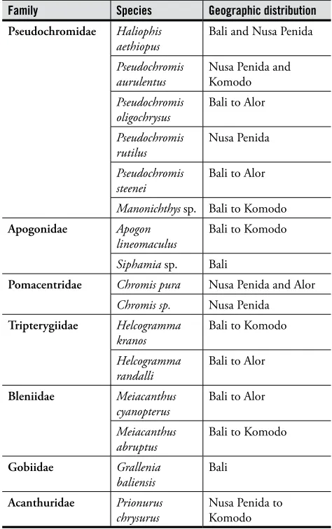
• At least 13 new and undescribed reef ish species were recorded and collected during the survey, including two fang blennies (Meiacanthus), two jawish ( Opistogna-thus), three dottybacks (Pseudochromis and Manonich-thys), a dartish (Ptereleotris), a clingish (Lepidichthys), a grubish (Parapercis), a cardinalish (Siphamia), and two gobiids (Grallenia and Priolepis). hough most of these undescribed species have been previously recorded from surrounding regions, ive were recorded for the irst time during the two MRAP surveys.
Table 1. Summary of survey sites for Bali MRAP 29 April – 11 May 2011.
Site No.
Date
Surveyed Location Name Coordinates
1 29 April 11 Terora, Sanur (Grand Mirage) 08° 46.228' S, 115° 13.805' E
2 29 April 11 Glady Willis, Nusa Dua (Grand Mirage) 08° 41.057' S, 115° 16.095' E
3 29 April 11 Sanur Channel 08° 42.625' S, 115° 16.282' E
4 30 April 11 Kutuh Temple, Bukit 08° 50.617' S, 115° 12.336' E
5 30 April 11 Nusa Dua 08° 48.025' S, 115° 14.356' E
6 30 April 11 Melia Bali, Nusa Dua 08° 47.608' S, 115° 14.192' E
7 1 May 11 West Batu Tiga (Gili Mimpang) 08° 31.527' S, 115° 34.519' E
8 1 May 11 East Batu Tiga 08° 31.633' S, 115° 34.585' E
9 1 May 11 Jepun (Padang Bai) 08° 31.138' S, 115° 30.619' E
10 2 May 11 Tepekong (Candidasa) 08° 31.885' S, 115° 35.167' E
11 2 May 11 Gili Biaha/Tanjung Pasir Putih 08° 30.270' S, 115° 36.771' E
12 3 May 11 Seraya 08° 26.010' S, 115° 41.274' E
13 3 May 11 Gili Selang North 08° 23.841' S, 115° 42.647' E
14 3 May 11 Gili Selang South 08° 24.079' S, 115° 42.679' E
15 4 May 11 Bunutan, Amed 08° 20.731' S, 115° 40.826' E
16 4 May 11 Jemeluk, Amed 08° 20.221' S, 115° 39.617' E
17 4 May 11 Kepa, Amed 08° 20.024' S, 115° 39.244' E
18 5 May 11 Batu Kelibit, Tulamben 08° 16.696' S, 115° 35.826' E
19 5 May 11 Tukad Abu, Tulamben 08° 17.603' S, 115° 36.599' E
20 6 May 11 Gretek, Buleleng 08° 08.969' S, 115° 24.733' E
21 6 May 11 Penutukang, Buleleng 08° 08.270' S, 115° 23.622' E
22 7 May 11 Puri Jati, Lovina 08° 11.032' S, 114° 54.869' E
23 7 May 11 Kalang Anyar, Lovina 08° 11.344' S, 114° 53.841' E
24 8 May 11 Taka Pemuteran 08° 07.775' S, 114° 40.007' E
25 8 May 11 Sumber Kima 08° 06.711' S, 114° 36.451' E
26 9 May 11 Anchor Wreck, Menjangan 08° 05.467' S, 114° 30.131' E
27 9 May 11 Coral Garden, Menjangan (transect only) 08° 05.485' S, 114° 30.486' E
28 9 May 11 Post 2, Menjangan 08° 05.813' S, 114° 31.608' E
29 10 May 11 Secret Bay, Gilimanuk 08° 10.862' S, 114° 26.544' E
30 10 May 11 Secret Bay Reef North, Gilimanuk 08° 09.771' S, 114° 27.116' E
31 11 May 11 Klatakan Pearl Farm 1 08° 13.911' S, 114° 27.249' E
32 11 May 11 Klatakan Pearl Farm 2 08° 14.000' S, 114° 27.463' E
4 Rapid Assessment Program Executive Summary
• hough Bali hosts an astounding diversity of ishes for its size, we also found strong signs of overishing at nearly every site, with large reef ishes of commercial value nearly absent. In over 350 man-hours of diving, the survey team only recorded a grand total of three reef sharks (only at Gili Selang and Menjangan), three Napoleon wrasse (Cheilinus undulatus; observed only at Gili Selang and Tulamben), and four coral trout of the genus Plectropo-mus. Equally concerning, the team only recorded a grand total of ive marine turtles observed during the survey.
• From the perspective of reef ish assemblage structure, Bali is broadly divisible into four major zones: Nusa Penida, east coast (facing Lombok Strait), north coast, and Secret Bay (Gilimanuk). he developing Bali MPA Network should strive to include representative sites from each of these zones. Other than those areas already included in MPAs(including Menjangan, Nusa Penida, Tulamben and Amed), survey sites worthy of speciic conservation focus (based on remarkable ish diversity and excellent habitat conditions) include Batu Tiga, Gili Selang, Taka Pemuteran, Sumber Kima, and Secret Bay (Gilimanuk).
SURVEY RESULTS: HARD CORAL BIODIVERSITY
• Combining the 2008 Nusa Penida and 2011 Bali main-land MRAPs, a total of 85 sites (adjacent deep and shal-low areas) at 48 stations (individual GPS locations) were surveyed for hard coral biodiversity. Coral communities were assessed in a broad range of wave exposure, current and sea temperature regimes, and included all main habitat types: cool water rocky shores, cool water reefs with broad lats, warm water reefs with broad to narrow lats, and coral communities developed on predomi-nantly soft substrate.
• Bali hosts a diverse reef coral fauna, with a conirmed total of 406 reef-building (hermatypic) coral species. An additional 13 species were unconirmed, requiring fur-ther taxonomic study. At least one species, Euphyllia sp. nov. is new to science, and a second, Isopora sp., shows signiicant morphological diference from described spe-cies, such that there are likely to be more than 420 her-matypic Scleractinia present, in total. To place this in perspective with other regions surveyed within the Coral Triangle, this igure for overall coral species rich-ness is similar to those from Bunaken National Park and Wakatobi (392 and 396 spp. respectively), signiicantly higher than for Komodo and Banda Islands (342 and 301 spp. respectively), and lower than Derawan, Raja Ampat, Teluk Cenderwasih, Fak-Fak/Kaimana and Halmahera (all with ca. 450 spp. or more).
• Within-station (point) richness around Bali averaged 112 species (s.d. 42 spp.), ranging from a low of just
two species (at Station B22, a muddy non-reefal loca-tion) to a high of 181 species at B16 (Jemeluk, Amed). Other species-rich stations included the Anchor Wreck, Menjangan (168 spp., Station B26) and Penutukang (164 spp., Station B21).
• Using cluster analysis at the station level, ive major coral community types were identiied, related to levels of exposure to waves, currents/upwelling, substrate type and geographic location. hey include: the relatively sheltered north coast of Bali (Menjangan to Amed); wave exposed reefs along south Bali, south Nusa Penida and northwest Bali; clear-water, current-swept reefs of northern Nusa Penida (and several reefs of east Bali); fringing reefs of east Bali from Nusa Dua to Gili Selang; and several predominantly soft-bottom, marginal reef habitats including Puri Jati, Kalang Anyar and Secret Bay (Gilimanuk). hese ive communities were further sub-divided into ten main coral assemblages, with each of the ive communities characterized by a more-or-less distinctive suite of species and benthic attributes.
• Cover of living hard corals averaged 28%. Dead coral cover was typically low, averaging < 4% overall, such that the overall ratio of live to dead cover of hard corals was highly positive (7:1), indicative of a reef tract in moderate to good condition in terms of coral cover. Areas of high soft coral cover occurred on rubble beds, likely created by earlier destructive ishing, coral preda-tion and the localized dumping of coral down-slope during creation of algal farms. Minor evidence of recent and not-so-recent blast ishing and coral diseases was also present, the latter typically on tabular species of Acropora. Some localized damage from recreational diver impacts was also apparent. A very strong stress response (in the form of cyanobacterial growth) of corals in the southeast of Bali (Sanur and Nusa Dua) was likely linked with eutrophication and sewage seepage from coastal tourism development.
• Discovery of an undescribed species of Euphyllia on the east coast of Bali, and the presence of other appar-ently local endemic corals, notably Acropora suharsonoi, suggests that the region does have a degree of faunal uniqueness, possibly related to the strong current low through Lombok Strait. Given this situation, a precau-tionary approach demands that Bali’s reefs require care-ful management of local impacts, as replenishment from outside sources may be a prolonged process.
• Reefs of particularly high conservation value around mainland Bali were widespread along the east and north coasts, and include Jemeluk, Menjangan, Gili Tepekong, Penutukang, Bunutan, Gili Selang and Gili Mimpang. Coral communities of Nusa Penida difer signiicantly from those of the mainland of Bali, and are subject to diferent environmental conditions and human uses, and hence may require separate management focus. Reefs of high local conservation value around Nusa Penida include those at Crystal Bay, Toya Pakeh, Seko-lah Dasar and Nusa Lembongan.
• he wave-exposed south coast was not thoroughly surveyed because of large ocean swell. Many of the south coast reefs are highly prized for suring, and as such draw large numbers of tourists to Bali each year. In the latter respect, their future conservation should be considered a priority for maintaining surf tourism on the island (noting that the surf conditions are generated by the shallow reefs of the area). Further ofshore, the south coast also holds crucial migration corridors for cetaceans and other species.
• he presence of cool water upwelling and/or strong consistent current low in some areas (especially Nusa Penida and eastern Bali) may be particularly important in bufering the incident reefs against rising sea temper-atures associated with global climate change. As such, the Bali MPA Network should strive to include a signii-cant percentage of these reefs within it to best ensure climate change resilience in the network design.
SURVEY RESULTS: CORAL REEF CONDITION
• Coral reef condition was assessed at 27 of the survey sites utilizing a modiied “point-intercept transect” method. Two 50-meter transects were placed longitu-dinally along the reef face at each of two depths (5–7m and 10–14m) for a total of four transects per site. he reef benthos was recorded at 50cm intervals along each transect, using categories of live hard coral (identiied to genus level), soft coral, algae, other living benthos (eg, sponges, zoanthids), dead standing coral, coral rubble, and abiotic substrate (eg, sand, rock, silt). Percentage cover of each of these substrate categories was then
calculated, along with an index of coral mortality that compares the percentage of living and dead hard coral.
• At the 5–7m depth range, percentage of living hard coral ranged from 21.5–68%, averaging 45.3%. he highest percentage live coral at this depth was found at the Anchor Wreck (Menjangan), with the lowest at East Klatakan. At this depth range, live hard coral was the predominant substrate cover, followed by an average of 17.3% “abiotic substrate” and 11.3% coral rubble.
• At the 10–14m depth range, percentage of living hard coral ranged from 11–76%, with the highest cover recorded at Gili Tepekong and the lowest at Kutuh. On average, reefs at this depth range were dominated by hard coral (32.8%), followed by abiotic substrate (21.7%), soft coral (14.9%), and rubble (13.6%).
• In combining the results of both depth ranges, Bali’s reefs have an average live hard coral cover of 38.2%. Overall averages of other substrate types in descending order of abundance include: abiotic substrate (20.6%), rubble (12.6%), soft coral (12.1%), other living fauna (6.8%), algae (5.2%), and dead standing coral (4.6%).
• A total of 54 hard coral genera were recorded in the transect surveys, with three genera overall dominat-ing the reefs of Bali: Acropora (averaging 9.67% total coverage on each reef ), Porites (8.12%) and Montipora (3.92%).
• If hard and soft coral coverage is combined to give percentage live (hard + soft) coral cover, reefs on mainland Bali showed a range of 31.5–85% (average 54.2%) live coral cover in the 5–7m transects, with the highest igure recorded for Coral Garden, Menjangan and the lowest at Sumber Kima. In the 10–14m depth transects, live coral cover ranged from 12–80.5% (aver-age 47.7%), with the highest recorded at Nusa Dua and lowest at Tukad Abu. It is important to note that, while soft coral is pleasant for divers to look at and does provide shelter and food to certain reef organisms, it does not lay down permanent skeleton (ie, it does not contribute to reef-building) and hence a high percent-age of soft coral cover is not preferable for the long-term maintenance of reef structures.
6 Rapid Assessment Program Executive Summary
SURVEY RECOMMENDATIONS:
• Based upon the results of this survey, it is clear that the province of Bali should take decisive action to set up a network of multiple-use MPAs designed to protect the long-term sustainability of local community isheries livelihoods as well as the burgeoning marine tour-ism industry. MPAs must be designed, gazetted and managed with the strong participation of local coastal communities, tourism operators and civil society groups, and should be explicitly embedded within a coastal/marine spatial planning framework that seeks to minimize resource user conlict while clearly pri-oritizing those economic activities that are the most sustainable and beneit the greatest percentage of Bali’s communities.
• In order to ensure the recovery of larger reef ishes that both provide an important protein source for local communities while also serving as a primary attraction for divers and snorkelers, these MPAs must include signiicant “no-take” areas where all forms of ish-ing and resource extraction are prohibited in order to allow a refuge for these stocks to recover, grow and reproduce — thereby repopulating the reefs of Bali and eventually providing increased catches to ishers operat-ing outside of these no-take areas. To be efective, these no-take areas need to cover 20–30% of the important marine habitats of Bali.
• In designing the Bali MPA Network, it is very impor-tant to ensure that all major ish and coral community types are represented in the network — both to protect the full range of Bali’s marine biodiversity while also providing the greatest insurance for climate change resil-ience/adaptation. he results of the Bali MRAP suggest there are at least ive major coral community types (ish assemblages largely follow this pattern as well) around Bali, roughly dividing as: northern Nusa Penida; east coast of Bali from Nusa Dua to Gili Selang; north coast reefs of Bali from Amed to Menjangan; north coast soft-bottom habitats in Puri Jati/Kalang Anyar and Gilima-nuk Secret Bay; and high wave energy environments on the west and south coasts of Bali and south coast of Nusa Penida.
• In addition to capturing the representativeness of these ive major community types, the Bali MPA Network should also strive to include sites of speciic high conservation value due to extraordinary biodiversity, particularly intact habitats, rare or endemic species, or ish spawning aggregations or aggregations for clean-ing or nestclean-ing. Speciic sites recognized by the MRAP team as being of particularly high conservation value on the Bali mainland include Batu Tiga (Gili Mimpang),
Tepekong, Gili Selang, Tulamben, Amed (Jemeluk and Bunutan), Menjangan, Penutukang, Taka Pemuteran, Sumber Kima, and Secret Bay (Gilimanuk). Previous sites identiied of high conservation value in the Nusa Penida MRAP (both due to high biodiversity and for importance as cleaning sites for oceanic sunish and manta rays) include Crystal Bay, Toya Pakeh, Manta Point, North Lembongan, Batu Abah and Sekolah Dasar (Penida). he turtle nesting beach of Perancak was also previously identiied as being of particularly high conservation value. Each of these sites should at least be included in MPAs within the Bali network, and should in fact be strongly considered for inclusion in no-take zones where all ishing and resource extraction is prohibited.
• As a inal criterion in site selection/prioritization for the Bali MPA Network, reefs on the east coast of Bali (particularly around Candidasa and Padang Bai) and Nusa Penida are considered particularly important to include within the MPA network from the perspec-tive of climate change resilience; these reefs are subject to both strong currents as well as frequent cold-water upwelling (both a result of the oceanographic feature of the Indonesian hroughlow moving through the Lombok Strait) that should help minimize the efects of warming from climate change.
• Based upon survey indings of only three reef sharks observed in 350 hours of diving, as well as recent evidence of the wholesale slaughter of pregnant female thresher sharks in the waters between Padang Bai and Nusa Dua, the Bali government should strongly con-sider implementing legislation to create a shark sanctu-ary in Bali that outlaws the capture or killing of any shark species in Bali provincial waters. he creation of a Bali shark sanctuary will be well-received by the interna-tional press at a time when Bali is increasingly criticized for its environmental problems, and will prevent even further criticism when information on the thresher shark slaughter is exposed internationally. Moreover, such a move would keep Bali in good stead with its competitor destinations for marine tourism, as many of these (including the Maldives, Palau, Micronesia, the Bahamas, and Guam) have recently declared shark sanctuaries to strong international praise. In October 2011 alone, the Marshall Islands created the world’s largest shark sanctuary at 1,990,530 km2. Bali would be
• he last chapter also analyses secondary data on other marine mega fauna around the island (including whales, dolphins, sea turtles and manta rays). Important sites for Bali’s marine mega fauna are included in the seven MPA candidate sites identiied in June 2010. he 2011 Marine Rapid Assessment does not cover all crucial information for the design of an MPA network, such as mangrove distribution and basic oceanographic information. In depth analyses on social, cultural and economic contexts are also excluded from the report. Nevertheless, despite the absence of all required data, the Precautionary Principle dictates the immediate implementation of conservation management.
• Taking the above recommendations into account, we strongly recommend that the following nine regions within Bali be prioritized for development of MPAs (or improvement of MPA management in the case of those regions that have already gazetted MPAs): Peninsula region (Bukit Uluwatu to Nusa Dua), Nusa Penida, Padang Bai-Candidasa, Tulamben-Amed, Buleleng Timur (Tejakula), Buleleng Tengah (Lovina), Buleleng Barat (Pemuteran), Bali Barat National Park (including Menjangan and Secret Bay), and Perancak. Depend-ing on local conditions (oceanographic, political, and cultural), it may be appropriate in each of these regions to consider a single larger MPA, or a series of smaller MPAs; either way, it is important that all nine of these regions be prioritized within the Bali MPA Network. We also note that this recommendation should not preclude the gazettement of additional MPAs in areas we have not recommended as priority areas; new infor-mation (including data on factors the MRAP did not consider such as mangrove or seagrass distribution, etc) may strongly recommend this, or local communities may simply show strong motivation to implement an MPA.
• It is imperative that the Bali government and all stakeholders recognize that efective management of the MPA network will require serious enforcement eforts and will be a relatively expensive undertaking that will need signiicant governmental funding to succeed. he government should strongly consider working with the marine tourism sector to develop MPA user fee systems (such as those already working efectively in MPAs like Bunaken and Raja Ampat) that could contribute signii-cantly to the costs of enforcement and MPA manage-ment. he government should also consider allocating a percentage of tax revenues from both the tourism and isheries sectors towards management of the MPA network.
Chapter 1
8 Rapid Assessment Program
Chapter 1
1. INTRODUCTION
Bali’s coasts and sea support an array of very productive ecosystems that provide goods and services to its communities. he dom-inant tourism industry also contributes to the economic growth and prosperity of these communities. However, this industry has simultaneously created conlicts of interest between stakeholders and resource users. Uncontrolled coastal development has also triggered environmental degradation in Bali.
Anticipating the various impacts of Bali’s development, the provincial government has worked hard to create long-term man-agement strategies, for example, through the production of a spatial plan (Local Regulation No. 16/2009). An important com-ponent of this initiative is to design and implement Marine Protected Areas (MPAs) and a network of MPAs in Bali, focusing on sustainable and compatible economic activities (e.g., marine tourism, mariculture and sustainable artisanal isheries).
he Bali provincial government conducted a stakeholder workshop in June 2010 to kick-start the establishment of MPAs and a network of MPAs on the island. he workshop was organised by the Bali Marine and Fisheries Agency, the Nature Conserva-tion Agency, the University of Warmadewa, the University of Udayana, the United States Agency for InternaConserva-tional Development (USAID), Conservation International (CI) Indonesia, and the Bali Sea Partnership. It was attended by approximately 70 partici-pants from the provincial and regency level government agencies, universities, NGOs, private sectors, and community groups who work on Bali’s coastal issues.
he workshop resulted in several important recommendations, for example, the identiication of 25 priority sites to consider in the development of Bali MPAs and an island-wide MPA network. he suggested sites included those with existing management regimes (e.g., the Bali Barat National Park and Nusa Penida MPAs) and other locations without any legal management authori-ties. Later, seven out of the 25 priority sites were selected as MPA candidate sites. However, the 25 priority sites remain impor-tant in the future management of marine ecosystems in Bali.
A comprehensive study on the status of marine resources in Bali was considered important in the development of MPAs around the island. he Marine Rapid Assessment Program (MRAP) is a method to rapidly examine existing marine resources. his MRAP report thus contains basic data and information on the current status of marine resources in Bali to support manage-ment and conservation eforts.
1.1 Goals
he goals of Bali Marine Rapid Assessment Program (MRAP) are:
1. To assess the current state of Bali’s marine biodiversity (including coral reefs status, hard coral resilience levels, and the status of reef ish, echinoderms and crustaceans)
2. To collect detailed spatial data on biological features to consider in the development of MPAs, MPA zoning and an MPA network; with particular regard to the identiication of high value conservation areas for endemic and rare coral cover, reef ish, ish spawning and aggregation sites, coral communities exposed to anthropogenic activities, and other biological features
3. To record and integrate the socio-cultural and economic values of Bali’s communities into future MPA management
1.2 Method
Methods used in the 2011 Bali MRAP are methods that have been developed by Conservation International across more than 20 years. hey have been used in over 23 countries in the Indian, Paciic and Atlantic Oceans. he methods for coral reef and reef ish are as follows:
Chapter 1
A. Reef fish
he reef ish study was led by reef ish expert Dr. Gerald Allen using underwater visual census. he survey was con-ducted for 60–100 minutes per site. Every observed ish spe-cies was recorded using pencil on waterproof paper attached to a clipboard. Scientists conducted the irst surveys at a 30–50m water depth before proceeding to shallow water. Most of the time, the surveys were conducted at a 5–12m depth. he number and species of reef ish are usually more abundant at this depth. he team also recorded the substrate type (e.g., rocky, lat reef, drop of, cave, rubble or sand).
B. Hard coral (species diversity and reef status)
he hard coral survey was led by Dr. Lyndon DeVantier, a coral expert of more than 20 years. Surveys were conducted at several dive sites representative of a range of habitat types and environmental conditions (e.g., exposure, slope and depth).
Shallow and deep coral communities were surveyed at the same time at all dive sites. Diferent depths were surveyed at deeper slopes (usually deeper than 10m), shallow slopes, reef tips and reef lats (usually shallower than 10m).
During the 13 days of the MRAP survey, the team cov-ered 33 sites in an anti-clockwise fashion from the Kutuh Temple in southern Bali to Klatakan in western Bali (Figure 1.2, Table 1.1). he sites were selected based on the recom-mendations of the June 2010 workshop. hus, the survey was designed to allow the team to cover as many of the 25 poten-tial sites as possible. Combining the results of the 2011 mainland Bali MRAP (33 sites) with those of the 2008 Nusa Penida MRAP (19 sites), the data in this report cover 52 sites in total: representative information to describe the status of coastal ecosystems in Bali. An exception is made for the west-ern coast of Bali (southeast from Klatakan to Uluwatu); the survey of the western coast was made impossible due to strong currents and waves. hus, additional eforts need to be made to ensure that this part of the island is surveyed in the future.
Table 1.1. The list of survey sites for the Bali MRAP 29 April to 11 May 2011. The fish survey was not conducted in sites 6, 8 and 28. Site 26 was only surveyed for the reef fish component.
Site
No. Survey date Location name Coordinates
1 29 April 11 Terora, Sanur (Grand Mirage) 08° 46.228’ S, 115° 13.805’ E
2 29 April 11 Glady Willis, Nusa Dua (Grand Mirage) 08° 41.057’ S, 115° 16.095’ E
3 29 April 11 Sanur Channel 08° 42.625’ S, 115° 16.282’ E
4 30 April 11 Kutuh Temple, Bukit 08° 50.617’ S, 115° 12.336’ E
5 30 April 11 Nusa Dua 08° 48.025’ S, 115° 14.356’ E
6 30 April 11 Melia Bali, Nusa Dua 08° 47.608’ S, 115° 14.192’ E
7 1 May 11 Batu Tiga-Barat (Gili Mimpang) 08° 31.527’ S, 115° 34.519’ E
8 1 May 11 Batu Tiga-Timur 08° 31.633’ S, 115° 34.585’ E
9 1 May 11 Tanjung Jepun (Padang Bai) 08° 31.138’ S, 115° 30.619’ E
10 2 May 11 Gili Tepekong (Candidasa) 08° 31.885’ S, 115° 35.167’ E
11 2 May 11 Gili Biaha/Tanjung Pasir Putih 08° 30.270’ S, 115° 36.771’ E
12 3 May 11 Seraya 08° 26.010’ S, 115° 41.274’ E
13 3 May 11 Gili Selang-Utara 08° 23.841’ S, 115° 42.647’ E
14 3 May 11 Gili Selang-Selatan 08° 24.079’ S, 115° 42.679’ E
15 4 May 11 Bunutan, Amed 08° 20.731’ S, 115° 40.826’ E
16 4 May 11 Jemeluk, Amed 08° 20.221’ S, 115° 39.617’ E
17 4 May 11 Kepah, Amed 08° 20.024’ S, 115° 39.244’ E
18 5 May 11 Batu Klebit, Tulamben 08° 16.696’ S, 115° 35.826’ E
19 5 May 11 Tukad Abu, Tulamben 08° 17.603’ S, 115° 36.599’ E
20 6 May 11 Alamanda, Buleleng 08° 08.969’ S, 115° 24.733’ E
21 6 May 11 Penuktukan, Buleleng 08° 08.270’ S, 115° 23.622’ E
22 7 May 11 Puri Jati, Lovina 08° 11.032’ S, 114° 54.869’ E
23 7 May 11 Kalang Anyar, Lovina 08° 11.344’ S, 114° 53.841’ E
24 8 May 11 Taka Pemuteran 08° 07.775’ S, 114° 40.007’ E
25 8 May 11 Sumber Kima 08° 06.711’ S, 114° 36.451’ E
26 9 May 11 Anchor Wreck, Menjangan 08° 05.467’ S, 114° 30.131’ E
27 9 May 11 Coral Garden, Menjangan 08° 05.485’ S, 114° 30.486’ E
28 9 May 11 Post 2, Menjangan 08° 05.813’ S, 114° 31.608’ E
29 10 May 11 Secret Bay, Gilimanuk 08° 10.862’ S, 114° 26.544’ E
30 10 May 11 Secret Bay Reef -utara, Gilimanuk 08° 09.771’ S, 114° 27.116’ E
31 11 May 11 Klatakan- Pearl Farm 1 08° 13.911’ S, 114° 27.249’ E
32 11 May 11 Klatakan-Pearl Farm 2 08° 14.000’ S, 114° 27.463’ E
Chapter 1
10 Rapid Assessment Program
Figure 1.1. Priority sites to be developed as MPAs in Bali (the result of a stakeholder workshop in June 2010)
2.1 NUSA DUA
Nusa Dua is a 350 ha elite tourism site located at the southernmost corner of Bali. he arid and nonproductive land of the area was acquitted by the government in the 1970s for tourism development. As a result, Nusa Dua has been designed as a com-prehensive tourism resort. Built away from the residential area of Bualu village, it ofers several places of interest, for example, a water blow and the beaches of Mengiat and Sawangan. Nearby underwater scenery also attracts divers. Nusa Dua is managed by the state company Bali Tourism Development Corporation (BTDC). Several mega hotels, for example, Nikko, Grand Hyatt, Ayodya Resort, Club Med and Nusa Dua Beach are found here.
2.2 SANUR
Sanur stretches from the Padang Galak beach in the north to Merta Sari in the south. A tourist site located near the heart of Denpasar, it also serves as a thoroughfare for traic heading to Nusa Penida, the Benoa Harbour and Tanjung Benoa. By the 1980s, most Sanur residents were ishers who ished the waters of Sanur and as far as Nusa Dua and Uluwatu. Some of them also traveled to Nusa Penida and Lombok with simple outboard engines and trolling lines. Nowadays, only a small fraction of the villagers ish for daily needs. Most Sanurians are now working in the tourism sector, using their traditional boats (jukungs) to take tourists sailing and ishing.
2.3 PADANGBAI
Located at Amuk/Padang Bay, Padangbai is a port that serves as Bali’s eastern entrance gate. It harbours ferry boats that con-nect Bali, Lombok and Nusa Penida, in addition to tour boats that roam the local waters of Padangbai (Goat Island and Blue Lagoon) and Nusa Penida.
he economy of Padangbai depends on tourism and ferry-crossings. It has several tourism sites, for example, the Blue Lagoon and Bias Tugel beaches. Both of these white sand beaches are frequented by foreign tourists, and are popular for being rather isolated and providing degree of privacy. Most tourists came from Europe (Germany) or Asia. Peak season is from July to August and in December.
Although most of the boats in Padangbai are now used for tourism, some of them still used for ishing. hese ishing boats are relatively smaller, and some are made of iberglass. Padangbai ishers still use local waters to catch ish, although they also travel to Nusa Penida and Lombok for this purpose. Sharks are occasionally caught in the triangle section between Padangbai, Gili Tepekong and Nusa Penida.
Chapter 2
Location Description
Chapter 2
12 Rapid Assessment Program 2.4 CANDIDASA
Candidasa is another tourism site located in Amuk Bay, Karangasem, irst established for this purpose around the 1980s. Candidasa is named after a local temple, however due to its close proximity to a large pond, the Candidasa Temple is also often referred to as the Telaga Kauh (the West Lake) Temple.
Despite not being as popular as Sanur and Kuta, Can-didasa is a choice for tourists who want to enjoy east Bali’s marine and terrestrial tourist attractions. Visitors are usually Europeans (mostly Germans and Dutch). Many Asian tour-ists also visit the site.
Candidasa ofers similar attractions to Padangbai; tourists may enjoy the sea by sailing, ishing, snorkeling or div-ing. he closeness between two sites means that Candidasa dive operators use the same diving sites as Padangbai’s, i.e., Tanjung Jepun, Gili Mimpang, Gili Biaha, Gili Tepekong, as well as Blue Lagoon.
Tourism provides an alternative income for Candidasa ishers. As they inish their daily ishing activities, they will often ofer to take tourists ishing, snorkeling or diving, in small boats accommodating up to three customers per trip. An association regulates the tour guide roster.
2.5 SERAYA
he rocky shores of Gili Selang in Seraya are frequently visited by experienced divers due to its amazing underwater scenery and strong, unpredictable currents. No homestays or restaurants are found around Gili Selang despite its popular-ity as a dive site. Most divers come from Amed, including Bunutan and Jemeluk.
Some residents along the coast of Gili Selang are ishers who operate between 4am and 10am with outboard engines of 8–15 HP. Some also cultivate cassava or raise cows, pigs and goats for extra income. he Gili Selang ishers do not
catch sharks, which are rare in the area. Aquarium ishers from Tembok often roam the waters of Gili Selang; travel-ling by land and camping on the beach. Fishers from other regions also sometimes come by boat and use compressors to catch aquarium ish.
2.6 AMED
Located in east Bali, Amed is renowned not only for its beau-tiful underwater scenery but also the Japanese ship that sunk here during World War II. It has several dive sites: Bunutan, Jemeluk and Kepah. Amed’s high season is around June to August, with most tourists coming from Europe, although Asians (particularly domestic and Japanese) also frequent this isolated place. Tourists usually come just for diving, thus the general trend is not to stay overnight in Amed.
As with many coastal villagers, the people of Amed are mostly ishers. Some of them only do this on a part-time basis however, occassionally also transporting guests to adjacent tourism sites, or working in restaurants. Tour guide associations regulate the ishers’ tour schedule with a roster system. Tourists usually dive, snorkel, ish or sail along the coasts of Amed. Boats from other places also take divers to Jemeluk; these boats have to pay a local village parking fee.
2.7 TULAMBEN
Tulamben is also located in Karangasem, a short distance away from Amed. Tukad Abu Beach is one of the most popular beaches in Tulamben with several villas and restau-rants on its shore. Tukad Abu also has several diving sites, for example, Batu Klebit and Batu Belah which ofer unique underwater features for photography.
Coastal residents of Tulamben are primarily ishers or tourism workers. he ishers often catch frigate mackerels for sale at the local market (Timbrah) or to villa/restaurant man-agers. Lately, many of them have been worried by declining and unpredictable ish harvests. Accordingly, some Fish Aggregation Devices (FADs) have been installed to increase harvest rates.
he ishers of Tukad Abu used to catch sharks in the past by applying long lines approximately 300–500m from the shore. he shark harvest season would take place from the fourth to the ifth month of the Balinese calendar, or the equivalent of August to October. However, shark ishing is no longer conducted due to the various mooring buoys and boats now occupying the “traditional” harvesting area. Tourists who complained about the practice also helped to eliminate this activity.
2.8 TEJAKULA
Tejakula, an administrative district of Buleleng Regency in the north, is a booming marine tourism location. Two famous diving sites here are Alamanda (Gretek Beach) and Penuktukan: two black-sand beaches in Sambirenteng Vil-lage. he name “Alamanda” was taken from a local resort and dive operator of the same name. Penuktukan is located close to Alamanda, also in the District of Tejakula.
Not many ishers live around Alamanda. In the 1970s, many villagers became citrus farmers or harvested corals for prestige. When the coral harvesting was prohibited and the citrus crops were attacked by virus in the 1980s, many villag-ers left their old professions to work instead in construction in Singaraja or Denpasar. In Penuktukan, some villagers are still active ishers to date. hey are banded together in a isher association through which they kite ish frigate mack-erel found around Fish Aggregation Devices or catch lying ish with nets.
2.9 SERIRIT
Puri Jati and Kalanganyar are renowned dive sites around Seririt. Most divers are from Asia, particularly Japan, however, Puri Jati is also popular among European and even domestic divers. High season is from June to August. Divers usually visit from, and stay overnight in, Pemuteran or Lovina; despite its fame as an underwater photography spot, not many tourism facilities are available in Puri Jati and Kalanganyar. However, the beach is accessible by motorized vehicles.
Most Puri Jati villagers work as farmers, labourers or pri-vate employees. Some also work in the subak-style irrigated paddy ields found in the vicinity of Puri Jati. he major-ity of coastal villagers in the area are not active ishers, and many that do own boats are no longer active. In Kalang-anyar, the number of ishers has also been declining; in the 1980s there were hundreds of them, nowadays they number only in the tens. Most Kalanganyar ishers are now farmers and labourers instead.
2.10 PEMUTERAN
Located not far from Pulaki Temple in Gerokgak District, Singaraja, Pemuteran is a booming site equipped with hotels/villas, restaurants and other service providers for visit-ing tourists. Tourism activities most favoured in Pemuteran are snorkeling and diving. Dive operators ofer packages to Pemuteran and Menjangan Island. In addition to beauti-ful corals and diverse ish, Pemuteran is also famous for its Biorock Technology that uses low electrical current to build artiicial reefs to attract ish and divers. Sea turtles are another interesting attraction for Pemuteran. Tourists can view sea turtles directly at a local resort which is also involved in recruiting the local community to participate in the “Sea Turtle Project”: where nests found along the coast are relocated to artiicial nesting sites. Post-hatching, sea turtle hatchlings are then released back to the sea. he local community, hoteliers and restaurateurs in Pemuteran all participate in irmly suggesting to tourists that they avoid disturbing coral reefs and other marine biota; a strong com-mitment applauded by many.
Chapter 2
14 Rapid Assessment Program 2.11 MENJANGAN ISLAND
Menjangan Island is located in the Bali Barat National Park. Administratively, it is situated in the Gerokgak District of Buleleng Regency. he underwater beauty of the coast of Menjangan is a magnet for divers. Both divers and tourists reach the island from the ports of Labuan Lalang or Banyu Wedang in the morning and return in the afternoon. Most tourists are Europeans from the Netherlands and France, although Asian tourists (e.g., Japanese and Koreans) also frequent the island.
Traditional ishing still occurs in Menjangan. Fishers come from Java or Bali, operating in the afternoon after the tourists have left the island. When the next morning comes, bringing the tourists back, the ishers disappear one by one.
2.12 GILIMANUK BAY
Gilimanuk Bay is also located in the Bali Barat National Park, although administratively it belongs to the Jembrana Regency. he Bay is shallow (approximately 10 meters), and has two small islands. It is often frequented by international and local tourists, although the latter only come to ish or enjoy the scenery. Muck diving and underwater photography are also often conducted here. he local community ofers restaurants, and services and facilities related to diving, for tourists.
2.13 MELAYA
he waters of Melaya are often frequented by sardine ishers. Despite its beauty, Melaya’s underwater attractions are still relatively unknown. Visitors are mostly locals who mainly come during holidays to enjoy the coastal scenery.
SUMMARY
• A list of ishes was compiled for 29 survey sites. he survey involved approximately 80 hours of scuba diving by G. Allen and M. Erdmann to depths of 70 m.
• A total of 805 species was recorded for the survey.
• Combined with previous survey eforts by the authors, primarily at nearby Nusa Penida in 2008, the current total for the Bali region is 977 species in 320 genera and 88 families.
• A formula for predicting the total reef ish fauna based on the number of species in six key families (Chaetodontidae, Poma-canthidae, Pomacentridae, Labridae, Scaridae, and Acanthuridae) indicates that as many as 1,312 species can be expected to occur in the Bali region.
• Wrasses (Labridae), damselishes (Pomacentridae), gobies (Gobiidae), cardinalishes (Apogonidae), groupers (Serranidae), butterlyishes (Chaetodontidae), and surgeonishes (Acanthuridae) are the most speciose families