Seismic imaging in the frontal part of the Sveconorwegian
orogen, south-western Sweden
Christopher Juhlin
a,*, Carl-Henric Wahlgren
b, Michael B. Stephens
baDepartment of Earth Sciences,Uppsala Uni
6ersity,Villa6a¨gen16,SE-752 36Uppsala,Sweden
bGeological Sur
6ey of Sweden,Box670,SE-751 28Uppsala,Sweden
Received 9 August 1999; accepted 31 January 2000
Abstract
Reflection seismic data have been acquired along a 17 km profile in the eastern frontal part of the Sveconorwegian orogen, south-western Sweden. Receiver spacing was 25 m and nominal shot spacing 100 m. Shots ranging in size from 0.5 to 1.0 kg were fired in 3 m deep shot holes. The data image the structure of the upper part of the crust from depths of a few 100 m down to depths of approximately 10 km. The profile crosses the central axis of an inferred fan-like structure, indicated from earlier, detailed surface mapping results. Deformational fabrics within this structure dip approximately 15 – 40°E in the western part of the profile and 60 – 80°W in its eastern part. The seismic data display a bivergent geometry with the central axis situated approximately 8 km east of a major fault (Protogine Zone in earlier studies). Surface structural data predict the hinge axis to be located about 3 km farther east. Despite this discrepancy, there is good general agreement with the structure inferred from the surface data. The image obtained from the reflection seismic data establishes that the fan-like structure is a major, upper crustal feature. The present data in combination with previous deep seismic data sets exclude a single-stage extensional model, with an east-dipping extensional deformation zone protracting eastwards from the western part of the profile. The combined seismic data provide support for a two-stage compressional model for the development of the fan-like structure, with crustal thickening and stacking prior to 955 Ma and later compression with a stronger horizontal component of displacement during 930 – 905 Ma. The latter gave rise to the development of the complex system of retrogressive deformation zones referred to as the Sveconorwegian Frontal Deformation Zone (SFDZ), a tectonic analogy to the Grenville Front in the eastern part of North America. The SFDZ dips westwards, may become listric at depth and possibly sole in a zone of lower crustal reflectivity west of the present profile. The kinematics and geometry of the SFDZ suggest that reverse displacements (thrusting) may be responsible, at least in part, for the exhumation of the medium- to high-grade rocks in the western part of the fan-like structure. Both the seismic data and the surface structural geology show many similarities to the Grenville Front. © 2000 Elsevier Science B.V. All rights reserved.
Keywords:Shear zone; Migration; Seismic reflection; Upper crust; Compression
www.elsevier.com/locate/precamres
* Corresponding author. Tel.: +46-18-4712392; fax: +46-18-501110. E-mail address:[email protected] (C. Juhlin)
1. Introduction
Over the last 20 years, the seismic reflection method has proven to be a useful tool for studying the structure of crystalline continental crust in Sweden and elsewhere. Particular cases of interest include definitive identification and mapping of fracture zones in central Sweden (Juhlin et al., 1991; Juhlin, 1995), identification of dolerite and felsic sills or sheets in the Siljan area of central Sweden (Juhlin, 1990), and the identification and mapping of mylonite zones in a number of areas in North America (Hurich et al., 1985; Johnson and Smithson, 1985; Ratcliffe et al., 1986). These studies and others have clearly shown that it is possible to obtain good images of the crust in the depth range of a few hundred meters to 10 km. Normally, the seismic reflection method can image discontinuities in the crust with dips in the range 0 – 45°, but re-cent studies show that it is possible to image discontinuities with dips up to 60 – 70° (Milkereit et al., 1992a). These images demonstrate a geo-metric picture of boundaries in the crust which then need to be interpreted in relation to surface geology and other geophysical information. In addition to the geometric picture, it is also pos-sible in some cases to obtain information on the physical properties of these discontinuities (Goodwin et al., 1989; Juhlin et al., 1991).
Much of the recent work in the Sveconorwe-gian orogen of south-western Sweden has fo-cused on detailed kinematic (e.g. Larson et al., 1986, 1990; Andre´asson and Rodhe, 1990; Park et al., 1991; Wahlgren et al., 1994; Stephens et al., 1996) and metamorphic (e.g. Johansson et al., 1991; Johansson and Kullerud, 1993; Wang and Lindh, 1996; Mo¨ller, 1998, 1999) studies, as well as geochronological work with the aim to constrain the timing of deformation and meta-morphism (e.g. Johansson et al., 1991; Jo-hansson and JoJo-hansson, 1993; Connelly et al., 1996; Page et al., 1996a,b; Wang et al., 1996; So¨derlund et al., 1999). The results of these studies strongly argue for a collisional tectonic scenario to explain the Sveconorwegian orogenic belt (cf. Berthelsen, 1980; Falkum and Petersen, 1980; EUGENO-S Working Group, 1988) which
is similar to that suggested for the Grenville orogen (e.g. Rivers, 1997). Late-Sveconorwegian extension has been suggested to explain decom-pression and exhumation of eclogites in the southernmost part of the orogen (Mo¨ller, 1998, 1999). However, current models and interpreta-tions of the Sveconorwegian orogen are con-strained primarily by surface geological information.
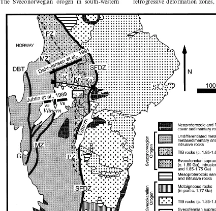
A major question concerns the tectonic devel-opment of the frontal part of the orogen, north and east of Lake Va¨nern (Fig. 1). In order to add a third data dimension, a c.17 km long reflection seismic profile was shot in this area to better constrain the 3D geometry of the defor-mation zones and their defordefor-mational history. The bedrock in and north of the Lake Va¨nern area has previously been explored by seismic methods. These data show that the crust is quite reflective down to Moho depths below Lake Va¨nern (Juhlin et al., 1989) and in the upper 5 – 6 km north of the lake (Dahl-Jensen et al., 1991). However, these experiments were de-signed to study the deeper portions of the crust and little to no information was obtained shal-lower than 1 – 2 km.
Wahlgren et al. (1994) discussed different models-compressional, extensional and various combinations of these-to explain the tectonic evolution in the frontal part of the Sveconorwe-gian orogen, north and east of Lake Va¨nern. A model involving two separate compressional events was favoured, and support for this was obtained in a recent 40
Ar/39
Ar study (Page et al., 1996a). Since the different tectonic models show similar features at the surface, but differ at depth, the sub-surface structural geometry is crucial for the discrimination between the mod-els.
its tectonic evolution. A short comparison with the results of seismic reflection studies and the tectonic evolution in the Grenville orogen is also presented.
2. Geological setting
The Sveconorwegian orogen in south-western
Sweden (Fig. 1) is 600 km long and up to 200 km wide. It continues westwards and northwards into the southern part of Norway and farther north is buried beneath the Scandinavian Caledonides.
Flat-lying thrusts and major, retrogressive, duc-tile deformation zones with moderate to steep dips, are conspicuous structural elements in the Sveconorwegian orogen. A complex system of retrogressive deformation zones, the
gian Frontal Deformation Zone or SFDZ (Wahlgren et al., 1994), forms the eastern boundary of the orogen and corresponds more or less to the Sveconorwegian front of Berthelsen (1980). The SFDZ is a tectonic anal-ogy to the Grenville Front (GF) in North America (Wynne-Edwards and Hasan, 1970; Gower and Owen, 1984; Gower, 1985). South of Lake Va¨ttern (Fig. 1), the frontal deformation zone is equivalent to the so-called Protogine Zone (PZ; Gorbatschev, 1980; see also Larson et al., 1990), and marks a sharp tectono-metamor-phic break between the Sveconorwegian orogen to the west and the Svecokarelian orogen to the east.
The Sveconorwegian orogen has been divided into three, major litho-tectonic units, the East-ern, Median and Western segments (Berthelsen, 1980; Larson et al., 1990; Park et al., 1991). These are separated by ductile deformation zones with approximately N-S strike and are re-ferred to as the Mylonite Zone (MZ) between the Eastern and Median segments, and the Go¨ta A8lv Zone/Dalsland Boundary Thrust (DBT) be-tween the Median and Western segments (Fig. 1). The litho-tectonic units are dominated by more or less highly deformed and metamor-phosed intrusive rocks with protolith ages in the time-range c. 1.85 – 1.55 Ga. In the north-eastern frontal part of the orogen, both supracrustal and intrusive rocks as old as c. 1.9 Ga occur. Pre-Sveconorwegian intrusive rocks with ages between 1.55 and 1.22 Ga, a prominent, low-grade, supracrustal sequence, the Dal Group, with an age less than c. 1.22 Ga, and late- to post-Sveconorwegian, c. 0.92 Ga granites are also conspicuous west of the MZ.
North and east of Lake Va¨nern, the Eastern Segment of the Sveconorwegian orogen is domi-nated by intrusive rocks belonging to the c. 1.85 – 1.65 Ga Transscandinavian Igneous Belt (TIB). All age-generations of TIB intrusions have been recorded in the area. The older c. 1.85 – 1.78 Ga intrusions dominate in the east-ern, frontal part of the orogen, while U-Pb zir-con and titanite ages demonstrate that the
younger c. 1.71 – 1.66 Ga intrusions dominate farther west (So¨derlund et al., 1999). A signifi-cant lithological component in the TIB-domi-nated area north of Lake Va¨nern is c. 1.57 and 1.47 Ga dolerite dykes (Welin, 1994; Wahlgren et al. 1996). The youngest rocks which are af-fected by ductile deformation are c. 1.00 – 0.90 Ga dolerite dykes.
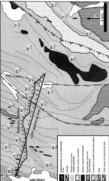
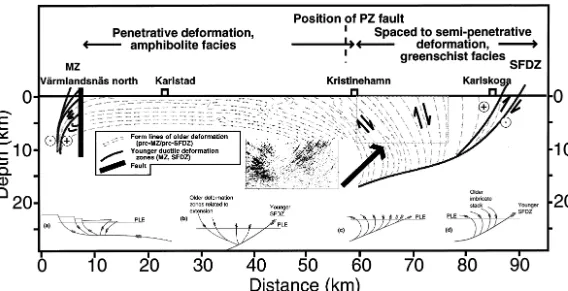
During the c. 1.1 – 0.9 Ga Sveconorwegian orogeny, all these rocks were more or less strongly deformed and metamorphosed. The sig-nificant contrast in trend between pre-Sveconor-wegian (Svecokarelian) structures to the east and Sveconorwegian structures with a c. N-S strike to the west is displayed in the magnetic anomaly map over the area east of Lake Va¨nern (Fig. 2a). In the easternmost part of the orogen, the Sveconorwegian structural overprinting is spaced to semi-penetrative in the east and the deforma-tion becomes more or less penetrative in charac-ter farther west. The transition from penetrative to semi-penetrative deformation occurs near Kristinehamn, directly east of the PZ (Fig. 1) which, in this area, is a brittle fault zone (Wahlgren et al., 1994). In the easternmost part of the orogen, the Sveconorwegian deformation gave rise to both new fabric development and reorientation of older Svecokarelian structures into the Sveconorwegian c. N-S structural trend (Fig. 2a). The syn-deformational metamorphic grade increases progressively from low-grade in the east to medium- to high-grade in the west-ern, penetratively deformed area, which is in ac-cordance with the east to west increase in bulk strain.
far-ther to the east and dips steeply to the west in the eastern frontal part of the orogen. Dip-slip move-ments predominate and a kinematic analysis based on several reliable kinematic indicators has revealed a constant top-to-the-east sense of dis-placement across the entire fan-like structure. Prominent zones which belong to the younger SFDZ strike NNE-NE, dip westwards or are sub-vertical, and display dextral and reverse sense of shear (Wahlgren et al., 1994).
40
Ar/39
Ar age determinations of hornblende in the penetratively deformed area north of Lake Va¨nern have yielded ages in the range 1009 – 965 Ma, which has been inferred to be the minimum age for the crustal thickening event during which the regional shear foliation was developed (Page et al., 1996a). U-Pb ages of c. 976 and 956 Ma for
metamorphic titanites from the same area (So¨der-lund et al., 1999) confirm the Sveconorwegian age of the regional foliation. The preservation of ig-neous titanites in the same rocks indicate that no major tectono-thermal event has affected the Eastern Segment north of Lake Va¨nern from the time of TIB emplacement until the late Sveconor-wegian orogenic overprinting. 40Ar/39Ar white
mica ages in the time range 930 – 904 Ma are associated with the later, inferred compressional displacements along the SFDZ (Page et al., 1996a).
3. Previous seismic studies
Most previous seismic work in the study area
Fig.
has concentrated on determining the large-scale crustal structure. The eastern limit of the wide angle reflection/refraction EUGENO-S profile 3 (EUGENO-S Working Group, 1988) is located immediately west of the Sveconorwegian front, north of the study area. Upper crustal velocities along the eastern end of the profile range from 6.1 to 6.5 km/s. The profile did not continue far enough to the east to allow the lower crustal velocity structure and depth to Moho to be deter-mined in the area east of the PZ fault. Just west of this fault, the crustal thickness was estimated to c. 40 km and disruptions in the Moho were inferred farther to the west. The EUGENO-S Working Group (1988) interpreted both the frontal defor-mation zone and the MZ to be west-dipping features at depth. These structures were also in-ferred to penetrate the entire crust down to the Moho and to possibly disrupt the Moho boundary.
In conjunction with the large-scale refraction profiles of the EUGENO-S project, airgun profi-les were shot on Lake Va¨nern to investigate the MZ. The airgun shots were recorded by numerous refraction stations south of the lake and on two refraction stations east and west of the lake (Green et al., 1988b). The airgun shots were also recorded on the Va¨rmlandsna¨s peninsula by a 7 km long multi-channel reflection system (Juhlin et al., 1989).
The refraction station data (Green et al., 1988b) provided more detailed information on the veloc-ity structure, dips of interfaces and depth to Moho than the EUGENO-S profile 3. Green et al. (1988b) interpreted the Moho to dip about 5° to the east below Lake Va¨nern, reaching a depth of about 43 km below the eastern part of the lake. Several crustal wide-angle reflections were also observed. These were interpreted to originate from c. 100 m thick layers with either a positive or negative velocity contrast of about 0.4 km/s and dipping about 10° to the west. The reflection seismic images from the Va¨rmlandsna¨s survey (Juhlin et al., 1989) are consistent with the inter-pretation of Green et al. (1988b), where reflections from the upper crust are generally sub-horizontal or dip to the west whereas lower crustal reflectors dip to the east.
About 70 km north of the study area, a 100 km long deep seismic profile was acquired in three stages in the mid to late eighties (Dahl-Jensen et al., 1991). Reflectivity is weak along most of the profile. However, between the MZ and the PZ fault, strong sub-horizontal to gently east-dipping reflectivity is observed in the upper 2 s TWT (6 km). Farther east, the reflectivity weakens, but has a west-dipping pattern. Stephens et al. (1996) used this change in the dip pattern along the profile as support for the existence of the fan-like structure mentioned earlier.
Earthquake studies using arrival times from local events in the Lake Va¨nern area (Slunga, 1985) also indicate that the Moho dips to the east. On the basis of these earthquake studies, the Moho depth is estimated to be 44 km below the SFDZ.
4. Data acquisition
The westernmost limit of the seismic profile reported here is located close to the eastern shore of Lake Va¨nern (Fig. 2b), immediately east of the PZ fault. In this area, the tectonic foliation dips about 15 – 40° to the east. The profile extends to the south-east where the surface mapped deforma-tional fabric becomes progressively more steeply dipping, and is near-vertical about 1 km east of Bjo¨rneborg (Fig. 2b). The easternmost 3 km of the profile crosses an area where the surface mapped foliation dips about 60 – 80° to the west. Data were acquired over an 8 day period in August 1996 (Table 1). The eastern half of the profile (station 340 – 681) runs along the main road which connects Kristinehamn with De-gerfors via Bjo¨rneborg. No shots could be fired in Bjo¨rneborg (station 453 – 551) and this section of the profile was undershot. The undershooting im-plies that information in the upper 500 ms, corre-sponding to c. 1500 m depth, was not obtained below Bjo¨rneborg. The western half (station 1 – 340) runs mainly along small roads and across fields.
Table 1
Acquisition parameters for the seismic reflection survey
End-on and shoot-through
Nominal shot spacing 100 m
0.5–1 kg dynamite
Field low cut Out 250 Hz Field high cut
16 s Record length
Profile length 17 km
Total number of shots 144
There are several dips present in the data suggest-ing that dip moveout (DMO) corrections should be made prior to stacking. Attempts to use DMO were made, but the irregular shooting geometry resulted in that DMO was not successful in im-proving the stack. The final stacked section is shown in Fig. 5.
Migration of seismic data is necessary to place the reflecting events in their true spatial position. Wavefield migration of discontinuous reflections such as those in the final stack (Fig. 5) is difficult. Therefore, an automatic line drawing routine was
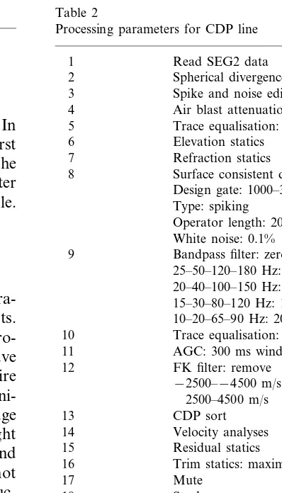
Table 2
Processing parameters for CDP line
Read SEG2 data 1
Spherical divergence correction 2
3 Spike and noise edit
Air blast attenuation: v=340 m/s 4
5 Trace equalisation: 1000–2500 ms 6 Elevation statics
Refraction statics 7
Surface consistent deconvolution 8
Design gate: 1000–3000 ms Type: spiking
Operator length: 200 ms White noise: 0.1% 9 Bandpass filter: zero phase
25–50–120–180 Hz: 0–1000 ms 20–40–100–150 Hz: 500–2000 ms 15–30–80–120 Hz: 1500–3000 ms 10–20–65–90 Hz: 2000–5000 ms 10 Trace equalisation: 1000–2500 ms
AGC: 300 ms window 11
12 FK filter: remove −2500–−4500 m/s
Trim statics: maximum 1 ms 16
17 Mute
18 Stack
19 AGC: 300 ms window Dynamic S/N Filtering 20
21 FX Decon: 20–100 Hz 22 Trace equalisation:
1000–3000 ms at CDP 1 0–2000 ms at CDP 1150 noisy as a result of the ironworks plant there. In
addition, wind noise was present during the first days of acquisition along the eastern half of the profile. These factors resulted in generally better data quality along the western half of the profile.
5. Data processing
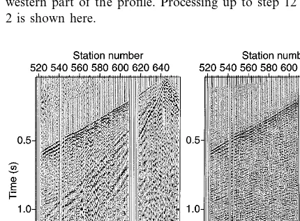
Fig. 3. Raw (a); and processed (b) shot records from the western part of the profile. Processing up to step 12 in Table 2 is shown here.
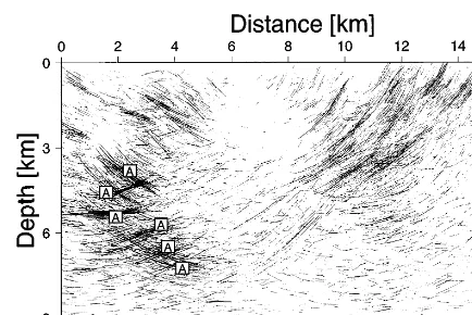
structural geometry for the reflecting elements with moderate to steep west-dipping reflectors in the east and more gently east-dipping reflectors in the west. The maximum dip of imaged reflections is approximately 60 – 70°. Superimposed on this geometry are higher amplitude, sub-horizontal to moderately dipping reflections in the western part of the section in the depth interval 3 – 7 km (marked A in Figs. 6 and 7).
TIB rocks probably do not contain significantly strong enough lithological contrasts in an unde-formed state to generate reflections. However, when sheared, lithological variations related to formation of mylonites may have developed and these variations can include large enough con-trasts in velocity and/or density to generate reflec-tions (Hurich et al., 1985; Ratcliffe et al., 1986; McDonough and Fountain, 1988). Sheared doler-ites within the TIB rocks may also have generated some of the reflectivity in the western part of the present profile. This interpretation was also sug-gested by Dahl-Jensen et al. (1991) for the deep seismic profile to the north.
The higher amplitude reflections in the west at depths between 3 and 7 km (A in Figs. 6 and 7) appear to transect the easterly-dipping lower am-plitude reflections. However, these reflections may emanate from out-of-the-plane of the profile. Sev-eral show a diffractive nature on the time section (Fig. 5), indicating they may originate from the northern or southern ends of near-vertical dolerite sheets situated south or north of the profile, respectively.
6.2. Comparison with surface geology
The bivergent structure of the lower amplitude dipping reflections is in good agreement with sur-face structural information (Fig. 8), with the ex-ception that the hinge line where the dip changes from east to west is displaced c. 3 km to the west on the seismic profile, relative to the surface geol-ogy. However, the number of observed surface structures are limited in the region of the hinge axis and west-dipping structures have been ob-served south of the profile at CDP 800. Surface dips are generally in the order of 15 – 50° west of the hinge line and 60 – 80° east of it. More steeply Fig. 4. Raw (a); and processed (b) shot records from the
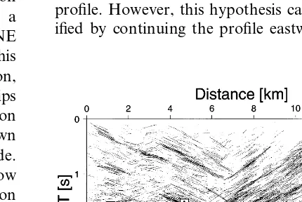
eastern part of the profile. Processing up to step 12 in Table 2 is shown here.
used to pick the strongest reflections in the final stack (Fig. 6). This line drawing of the stacked section was then migrated at a velocity of 6000 m/s and the resulting section (Fig. 7) forms the basis for the interpretation of the data.
6. Results
6.1. Reflecti6ity patterns
Fig. 5. Final stack with residual and trim statics. Reflection F is discussed in the text.
dipping structures east of the hinge line are also observed in the seismic data. The hinge line defined from the seismic data is located about 8 km east of the PZ fault (Fig. 8).
East of the major west-dipping reflectivity, a weak, steeply dipping reflection is observed which is prominent at about 1.8 s at the eastern end of the profile and extends to 3 s at CDP 800 (marked F in Figs. 5 – 7). Upon migration, this reflection steepens and projects to the surface close to a major deformation zone which strikes NNE through Degerfors (marked D on Fig. 8). This zone shows both strong ductile deformation, which belongs to the SFDZ system and dips steeply westwards, and later brittle reactivation along a major fault. The fault has downthrown Neoproterozoic sandstone on its western side. There remains some uncertainty concerning how much the relatively weak, but distinctive reflection (marked F in Figs. 5 – 7) is related to the older SFDZ or younger fault deformation.
Wahlgren et al. (1994) suggested a two-phase Sveconorwegian deformation history east of the MZ. Comparison of the geometry and location of the gently east-dipping reflectivity in the west with surficial geological data suggests that it developed during the early phase of crustal thickening and
was later modified during the late Sveconorwegian deformation. A similar analysis suggests that the west-dipping reflectivity along the eastern part of the seismic profile is essentially the result of the later phase of Sveconorwegian deformation. Be-low this zone of reflections, there is significantly less west-dipping reflectivity (F in Fig. 5 being the most distinct), suggesting that the Sveconorwe-gian deformation is less intense east of the present profile. However, this hypothesis can only be ver-ified by continuing the profile eastwards.
Fig. 7. Migrated line drawing of Fig. 6. Reflections A and F are discussed in the text. Note that the migrated section has been extended towards the east so that the easternmost, west-dipping reflections are not removed.
profiles. Thus, the results east of the PZ fault in the present study show the same geometry as the weak reflectivity observed in the upper crust along the deep seismic profile north of Lake Va¨nern.
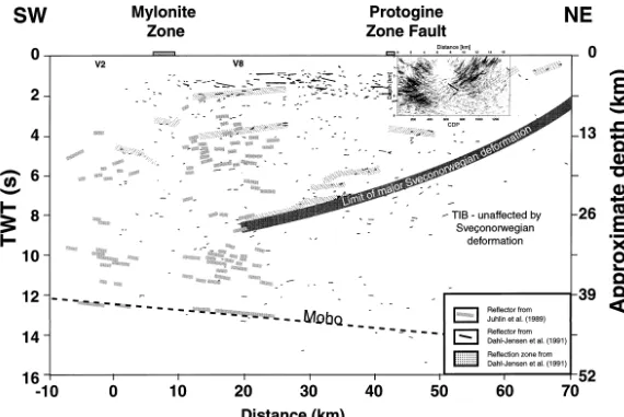
Dahl-Jensen et al. (1991) interpreted the reflections and zones of reflectivity between 4 and 8.5 s at distances between 30 and 50 km on the deep seismic profile north of Lake Va¨nern (Fig. 9) as major shear zones that may have developed during the Sveconorwegian orogeny. This interpretation was based on the increased reflectivity at these depths compared to the nearly transparent crust to the east. The present study is consistent with the crust east of the SFDZ being undeformed and a limit to major Sveconorwegian deformation may be roughly drawn based on the two studies (Fig. 9). This limit projects into west-dipping reflections on both the Va¨rmlandsna¨s deep seismic data and the deep seismic profile north of Lake Va¨nern (Figs. 1 and 9), and possibly soles into east-dip-ping lower crustal reflectivity farther west at 10 km distance at about 10 s (c. 35 km depth). The west-dipping reflections along the eastern part of the deep seismic profile and event F in Fig. 5 in this study indicate that the surface limit of ma-jor Sveconorwegian deformation lies to the east of both profiles, in agreement with surface geo-logical observations.
7. Discussion
7.1. The structural model
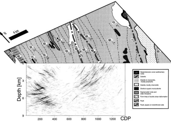
A comparison between the current structural model for the Kristinehamn-Karlskoga area (Wahlgren et al., 1994; Stephens et al., 1996) and the present seismic data (Fig. 10) shows, in a general sense, good agreement, although there are differences in detail. A number of factors may have caused these differences. Firstly, the seismic profile is located south of the structural profile where the zone of Sveconorwegian defor-mation east of the PZ fault is narrower. If the seismic profile had been located farther north, the zones of west-dipping reflectivity would
6.3. Comparison with the deep seismic profile north of Lake Va¨nern
C
.
Juhlin
et
al
.
/
Precambrian
Research
102
(2000)
135
–
154
Juhlin
et
al
.
/
Precambrian
Research
102
(2000)
135
–
154
147
probably have been spread out over a wider area. Secondly, the limit of Sveconorwegian deformation appears to occur farther west on the seismic data than on the surface geology, even after account is taken of the narrower belt of Sveconorwegian deformation in the area of the seismic profile. However, only a prolongation of the profile to the east by about 20 km can definitely reveal whether major deformation zones with a strong seismic signature exist east of the ones observed along the present profile. Finally, together with the deep seismic profile north of Lake Va¨nern, the seismic data suggest that the eastern limit of the SFDZ dips at a shallower angle than that indicated in the structural model of Stephens et al. (1996). Furthermore, the seismic data suggest that the SFDZ extends to about 30 km depth below Lake Va¨nern where it soles into lower crustal reflectivity (Fig. 9). This zone of lower crustal reflectivity may have formed during the Sveconorwegian orogeny and could represent the eastern limit of major Sveconorwegian deformation at depth. This would explain the lack of any strong crustal reflectivity eastwards within the undeformed TIB rocks.
The results of the reflection seismic surveys strongly support a two-stage development for the fan-like structure east and north-east of Lake Va¨nern (Wahlgren et al., 1994). Geometrical constraints based on the present seismic profile exclude a single extensional event (Fig. 10a) for the source of the fan-like
structure observed in the
Kristinehamn-Karlskoga area. The expected sub-surface geometry of an extensional event followed by later compression (Fig. 10b) and a single compressional event (Fig. 10c) are similar to that of two-stage compression (Fig. 10d). However, both these models preclude a more gradual rollover from east- to west-dipping structures than the two-stage compressional model. The seismic data from this study show a rapid change in structural dip from east to west over a few kilometres distance. Furthermore, the high density of both east- and west-dipping reflectors along the seismic profile and the surface geology indicate that these reflections
represent a mylonitic foliation formed in response to compressional deformation. Formation of mylonites in a compressional tectonic setting have been documented in a seismic study in the Grenville orogen in Quebec (Ji et al., 1997). Consequently, the present study together with the deep seismic profile north of Lake Va¨nern, support the preferred model interpretation of Wahlgren et al. (Fig. 10d) that the fan-like structure is the result of two pulses of compressional, Sveconorwegian deformation.
The east-dipping deformation zones which display top-to-the-east sense of displacement in the western part of the fan-like structure (Fig. 10) are interpreted to display only an apparent normal sense of shear. They are interpreted to have originated in a foreland-verging thrust system, which is inferred to be the initial result of oblique collision and crustal shortening. At this stage, the shortening was absorbed by thickening of the crust. The MZ overprinted this thrusting and is suggested to have formed during sinistral transpression in connection with escape-like tectonics (Stephens et al., 1996). In the frontal part of the orogen, the older compressional structures were rotated clockwise as a result of late Sveconorwegian compressional deformation which resulted in dextral and reverse movements along the SFDZ. This deformation marked the final expression of the oblique collision.
7.2. Reflecti6ity in TIB rocks—a S6econorwegian
signature
Juhlin
et
al
.
/
Precambrian
Research
102
(2000)
135
–
154
149
signal penetration does not appear to be the reason for the lack of lower crustal reflectivity (Juhojuntti and Juhlin, 1998). Since U-Pb data (So¨derlund et al., 1999) suggest that the rocks east of the MZ in the western part of Fig. 9 were undeformed TIB rocks prior to the Sve-conorwegian orogeny, we suggest that the present crustal reflectivity in this area developed in connection with this orogenic event. In the eastern part of the section, Sveconorwegian de-formation was insignificant below the SFDZ.
7.3. Comparison with the Gren6ille orogen
7.3.1. Seismic studies
Major deep seismic profiles across the Grenville Front (GF) (Green et al., 1988a; Pratt et al., 1989; Culotta et al., 1990) display distinct, moderately east-dipping (30 – 35°) reflection se-quences that are associated with the GF. Corre-lation with geological information implies that the base of this reflectivity defines the western limit of the GF in North America. The reflectiv-ity has been interpreted to be as a result of mylonite zones which developed in a compres-sive, ductile re´gime associated with the Grenvil-lian orogeny (Green et al., 1988a). Late- to post-orogenic collapse and extension are inferred (Milkereit et al., 1992b; Martignole and Calvert, 1996) to have followed the Grenvillian orogeny and gave rise to extensional structures. The pri-mary evidence for this extension is thinned crust where the GF reflection sequence projects into the Moho (Martignole and Calvert, 1996).
The composite seismic section across the East-ern Segment of the Sveconorwegian orogen north and north-east of Lake Va¨nern (Fig. 9) shows some similarities to the seismic images of the Grenville orogen in North America (Green et al., 1988a; Pratt et al., 1989; Martignole and Calvert, 1996; Hynes and Eaton, 1999). Reflec-tors which dip moderately to steeply towards the hinterland are conspicuous in the frontal parts of both orogens. Furthermore, this reflec-tivity is apparently related to ductile deforma-tion zones. Hynes and Eaton (1999) also interpret the GF in eastern Quebec to extend deep into the crust, giving it a similar geometry
to that of the SFDZ in Fig. 9. On the Western Quebec Seismic Transect (Martignole and Calvert, 1996), west-dipping (foreland-dipping) reflectors are observed between the Grenville Front and the Allochthon Boundary Thrust. This defines a bivergent geometry similar to that observed in the present study area. This biver-gent geometry is not observed farther south in the Grenville orogen (Green et al., 1988a). How-ever, in the Grenville basement beneath the Palaeozoic cover in Ohio in the eastern US mid-continent, a pair of oppositely dipping crustal-scale shear zones, one east-dipping and one west-dipping, have been imaged in a COCORP deep seismic survey (Culotta et al., 1990). The east-dipping shear zone is supposed to corre-spond to the Grenville Front Tectonic Zone (GFTZ), while the west-dipping zone is sug-gested to mark an intra-Grenville suture.
Despite the occurrence of oppositely or vari-ably dipping structures in the more internal parts of the Grenville and Sveconorwegian oro-gens, all profiles over or near the frontal parts of these orogens display hinterland-dipping reflectivity. The latter is interpreted to have de-veloped, at least initially, in a compressive duc-tile re´gime during thrusting over the stable forelands.
7.3.2. Tectonic e6olution
The south-western part of the GFTZ has been proposed to be a retro-shear which progrades into the stable foreland (e.g. Haggart et al., 1993; Jamieson et al., 1995; Reynolds et al., 1995) according to the geodynamic models for convergent orogens of e.g. Willett et al. (1993) and Beaumont and Quinlan (1994). The retro-shear developed in response to north-westerly transport of material from the hinterland of the Grenville orogen towards the stable foreland. Rapid exhumation of high-grade metamorphic rocks is suggested to have occurred in the hang-ing wall of the GFTZ (see also Bethune, 1997). A similar model has been presented for the frontal area in the north-eastern part of the Grenville orogen (Rivers et al., 1993).
the Sveconorwegian orogen north-east of Lake Va¨nern, i.e. the SFDZ may be an analogue to the geodynamically modelled retro-shear. The reverse movements in the SFDZ may have ini-tiated in the westernmost, west-dipping deforma-tion zones displayed in the seismic profile (Fig. 7). The deformation then propagated into the stable Svecokarelian foreland, and is represented by the easternmost deformation zones that over-print Svecokarelian structures and isotropic TIB rocks.
The kinematics along the SFDZ (Wahlgren et al., 1994) suggest that reverse displacements may be responsible, at least in part, for the exhuma-tion of the medium- to high-grade rocks in the western part of the fan-like structure, i.e. in the hanging wall of the SFDZ. Consequently, the metamorphic and structural relationships in the frontal part of the Sveconorwegian orogen in south-central Sweden support actualistic models, that reverse displacements (thrusting) in conver-gent orogens are inferred to be an effective mechanism for exhumation of high-grade meta-morphic rocks (e.g. Burg et al., 1997; Thompson et al., 1997a,b). However, the rate of thrust-re-lated exhumation is dependent on the obliquity of convergence. Lateral extrusion, as a result of oblique convergence, will lower the rate of verti-cal exhumation (Thompson et al., 1997a,b). Many of the deformation zones that build up the SFDZ east of Lake Va¨nern display a signifi-cant component of horizontal displacement. This may explain why the metamorphic break across the SFDZ in south-central Sweden is not as sharp as in southern Sweden, where high-pres-sure granulites occur immediately west of the SFDZ (PZ).
In the geodynamic modelling by Willett et al. (1993) and Beaumont and Quinlan (1994), the retro-shear is accompanied by a contemporane-ous pro-shear with opposite sense of vergence. No such crustal-scale shear zone that could qualify as the postulated pro-shear zone has been documented in either the Grenville or the Sveconorwegian orogen. The east-dipping defor-mation zones and associated reflectors in the western part of the fan-like structure in the Sve-conorwegian orogen display a suitable
orienta-tion which could be related to a pro-shear. However, the kinematics (top-to-the-east) does not support this interpretation. In large orogens, the retro- and pro-shear are not necessarily ad-jacent to each other, but may be widely sepa-rated (Willett et al., 1993; Beaumont and Quinlan, 1994).
8. Conclusions
Reflection seismic data were acquired along a 17 km long profile east of Lake Va¨nern, south-western Sweden. The data image the upper crust from depths of a few hundred meters down to depths of approximately 10 km. Reflectors dip-ping up to 60 – 70° have been imaged. The data show a bivergent geometry with its central axis about 8 km east of a major fault (PZ fault). Surface geological data indicate the expected hinge axis to be located about 3 km farther east. In spite of this discrepancy, there is good general agreement with the structure as defined by the surface geology and the image obtained by the reflection seismic experiment supports the fan-like structure interpretation (Wahlgren et al., 1994).
can only be verified by continuation of the seismic profile to the east. Deformation zones dipping to the west on the present profile are suggested to become listric at depth and sole into a zone of lower crustal reflectivity below Lake Va¨nern. If this is correct, it follows that this lower crustal reflectivity also developed during the Sveconorwe-gian orogeny. The absence of this lower crustal reflectivity beneath the TIB rocks to the east supports this hypothesis.
Available seismic data and surface geology from the Sveconorwegian orogen of south-western Sweden show many similarities with observations from the Grenville orogen. Hinterland dipping reflectors related to ductile deformation zones are observed in the frontal parts of both orogens. Towards the hinterland, oppositely dipping reflec-tivity has been documented in both cases. Retro-shear transport of material from the hinterland towards the foreland and exhumation of high-grade rocks appear to have occurred in both orogens.
Acknowledgements
Field work and processing costs for this study were funded by the Geological Survey of Sweden (SGU) under the auspices of a SGU external Research and Development grant (PROJECT NUMBER 03-890/94). H. Palm played an impor-tant role in the field acquisition stage of this project and L. Frenje contributed to the initial stages of the seismic data processing. C. Juhlin is funded by the Swedish Natural Sciences Research Council (NFR) and the work by C.-H. Wahlgren and M.B. Stephens has been funded by a SGU internal Research and Development grant. We thank D. Dyrelius and the referees T. Dahl-Jensen and B. Milkereit for their constructive comments on the manuscript.
References
Andre´asson, P.-G., Rodhe, A., 1990. Geology of the Protogine Zone south of Lake Va¨ttern, southern Sweden: a reinter-pretation. GFF 112, 107 – 125.
Beaumont, C., Quinlan, G., 1994. A geodynamic frame-work for interpreting crustal-scale seismic-reflectivity pat-terns in compressional orogens. Geophys. J. Int. 116, 754 – 783.
Berthelsen, A., 1980. Towards a palinspastic tectonic analy-sis of the Baltic Shield. In: Cogne´, J., Slansky, M. (Eds.), Geology of Europe from Precambrian to Post-Hercynian Sedimentary Basins. International Geological Congress Colloquim C6, Paris, pp. 5 – 21.
Bethune, K.M., 1997. The Sudbury dyke swarm and its bearing on the tectonic development of the Grenville front, Ontario, Canada. Precambrian Res. 85, 117 – 146. Burg, J.-P., Davy, P., Nievergelt, P., Oberli, F., Seward, D.,
Diao, Z., Meier, M., 1997. Exhumation during crustal folding in the Namche-Barwa syntaxis. Terra Nova 9, 53 – 56.
Connelly, J.N., Berglund, J., Larson, S.A,., 1996. Thermotec-tonic evolution of the Eastern Segment of southwestern Sweden: tectonic constraints from U-Pb geochronology. In: Brewer, T.S. (Ed.), Precambrian Crustal Evolution in the North Atlantic Region, Geol. Soc. Spec. Publ. 112, 297 – 313.
Culotta, R.C., Pratt, T., Oliver, J., 1990. A tale of two sutures: COCORP’s deep seismic surveys of the Grenville province in the eastern US midcontinent. Geology 18, 646 – 649.
Dahl-Jensen, T., Dyrelius, D., Palm, H., 1991. Deep crustal seismic reflection profiling across two major tectonic zones in southern Sweden. Tectonophysics 195, 209 – 240. EUGENO-S Working Group, 1988. Crustal structure and
tectonic evolution of the transition between the Baltic Shield and the North German Caledonides (the EUGENO-S Project). Tectonophysics 150, 253 – 348. Falkum, T., Petersen, J.S., 1980. The Sveconorwegian
oro-genic belt, a case of late Proterozoic plate collision. Geol. Rundsch. 69, 622 – 647.
Goodwin, E.B., Thompson, G.A., Okaya, D.A., 1989. Seis-mic identification of basement reflectors: the Bagdad reflection sequence in the Basin and Range province-Col-orado Plateau transition zone, Arizona. Tectonics 8, 821 – 831.
Gorbatschev, R., 1980. The Precambrian development of southern Sweden. GFF 102, 129 – 136.
Gower, C.F., 1985. Correlations between the Grenville Province and Sveconorwegian Orogenic Belt — implica-tions for Proterozoic evolution of the southern margins of the Canadian and Baltic Shields. In: Tobi, A.C., Touret, J.L.R. (Eds.), The Deep Proterozoic Crust in the North Atlantic Provinces. D. Reidel Publishing Com-pany, NATO Advanced Science Institute Series C 158, Dordrecht, pp. 247 – 257.
Green, A.G., Milkereit, B., Davidson, A., Spencer, C., Hutchinson, D.R., Cannon, W.F., Lee, M.W., Agena, F., Behrendt, J.C., Hinze, W.J., 1988a. Crustal structure of the Grenville front and adjacent terranes. Geology 16, 788 – 792.
Green, C.M., Stuart, G.W., Lund, C.-E., Roberts, R., 1988b. P-wave crustal structure of the Lake Va¨nern area, Sweden. Tectonophysics 150, 349 – 361.
Haggart, M.J., Jamieson, R.A., Reynolds, P.H., Krogh, T.E., Beaumont, C., Culshaw, N.G., 1993. Last gasp of the Grenville orogeny: thermochronology of the Grenville Front Tectonic zone near Killarney, Ontario. J. Geol. 101, 575 – 589.
Hurich, C.A., Smithson, S.B., Fountain, D.M., Humphreys, M.C., 1985. Seismic evidence of mylonite reflectivity and deep structure in the Kettle dome metamorphic core com-plex, Washington. Geology 13, 577 – 580.
Hynes, A., Eaton, D., 1999. Lateral ramps as an aid to the unroofing of deep crustal rocks: seismic evidence from the Grenville province. Tectonics 18, 343 – 360.
Jamieson, R.A., Culshaw, N.G., Corrigan, D., 1995. North-west propagation of the Grenville orogen: Grenvillian structure and metamorphism near Key Harbour, Georgian Bay, Ontario, Canada. J. Metamorphic Geol. 13, 185 – 207. Ji, S., Long, C., Martignole, J., Salisbury, M., 1997. Seismic reflectivity of a finely layered, granulite facies ductile shear zone in the southern Grenville Province (Quebec). Tec-tonophysics 279, 113 – 133.
Johansson, L., Johansson, A,., 1993. U-Pb age of titanite in the Mylonite Zone, southwestern Sweden. GFF 115, 1 – 7. Johansson, L., Kullerud, L., 1993. Late Sveconorwegian
meta-morphism and deformation in southwestern Sweden. Pre-cambrian Res. 64, 347 – 360.
Johansson, L., Lindh, A., Mo¨ller, C., 1991. Late Sveconorwe-gian (Grenville) high-pressure granulite facies metamor-phism in southwest Sweden. J. Metamorphic Geol. 9, 283 – 292.
Johnson, R.A., Smithson, S.B., 1985. Thrust faulting in the Laramie Mountains, Wyoming, from reanalysis of CO-CORP data. Geology 13, 534 – 537.
Juhlin, C., 1990. Interpretation of the reflections in the Siljan Ring area based on results from the Gravberg-1 borehole. Tectonophysics 173, 345 – 360.
Juhlin, C., 1995. Imaging of fracture zones in the Finnsjo¨n area, central Sweden, using the seismic reflection method. Geophysics 60, 66 – 75.
Juhlin, C., Dyrelius, D., Lund, C.-E., Palm, H., 1989. Crustal reflections underneath Lake Va¨nern, Sweden. Geophys. J. Int. 99, 567 – 578.
Juhlin, C., Lindgren, J., Collini, B., 1991. Interpretation of seismic reflection and borehole data from Precambrian rocks in the Dala Sandstone area, central Sweden. First Break 9, 24 – 36.
Juhojuntti, N., Juhlin, C., 1998. Seismic lower crustal reflectiv-ity and signal penetration in the Siljan Ring area, Central Sweden. Tectonophysics 288, 17 – 30.
Larson, S.A,., Stigh, J., Tullborg, E.-L., 1986. The deformation history of the eastern part of the southwest Swedish gneiss belt. Precambrian Res. 31, 237 – 257.
Larson, S.A,., Berglund, J., Stigh, J., Tullborg, E.-L., 1990. The Protogine Zone, southwest Sweden: a new model-an old issue. In: Gower, C.F., Rivers, T., Ryan, B. (Eds.), Mid-Proterozoic Laurentia-Baltica. Geol. Ass. Canada Spec. Paper, 38, 317 – 333.
Martignole, J., Calvert, A.J., 1996. Crustal-scale shortening and extension across the Grenville Province of western Quebe´c. Tectonics 15 (2), 376 – 386.
McDonough, D.T., Fountain, D.M., 1988. Reflection charac-teristics of a mylonite zone based on compressional wave velocities of rock samples. Geophys. J. 93, 547 – 558. Sudbury Working Group, Milkereit, B., Green, A.G., 1992a.
Deep geometry of the Sudbury structure from seismic reflection profiling. Geology 20, 807 – 811.
Milkereit, B., Forsyth, D.A., Green, A.G., Davidson, A., Hanmer, S., Hutchinson, D.R., Hinze, W.J., Mereu, R.F., 1992b. Seismic images of a Grenvillian boundary. Geology 20, 1027 – 1030.
Mo¨ller, C., 1998. Decompressed eclogites in the Sveconorwe-gian (-Grenvillian) orogen of SW Sweden: petrology and tectonic implications. J. Metamorphic Geol. 16, 641 – 656. Mo¨ller, C., 1999. Sapphirine in SW Sweden: a record of Sveconorwegian (-Grenvillian) late-orogenic tectonic ex-humation. J. Metamorphic Geol. 17, 127 – 141.
Page, L.M., Stephens, M.B., Wahlgren, C.-H., 1996a. 40Ar/ 39Ar geochronological constraints on the tectonothermal
evolution of the Eastern Segment of the Sveconorwegian orogen, south-central Sweden. In: Brewer, T.S. (Ed.), Pre-cambrian Crustal Evolution in the North Atlantic Region. Geol. Soc. Spec. Publ., 112, 315 – 330.
Page, L.M., Mo¨ller, C., Johansson, L., 1996b. 40Ar/39Ar
geochronology across the Mylonite Zone and the South-western Granulite Province in the Sveconorwegian orogen of S. Sweden. Precambrian Res. 79, 239 – 259.
Park, R.G., A,ha¨ll, K.-I., Boland, M.P., 1991. The Sveconor-wegian shear-zone network of SW Sweden in relation to mid-Proterozoic plate movements. Precambrian Res. 49, 245 – 260.
Pratt, T., Culotta, R., Hauser, E., Nelson, D., Brown, L., Kaufman, S., Oliver, J., Hinze, W., 1989. Major Protero-zoic basement features of the eastern midcontinent of North America revealed by recent COCORP profiling. Geology 17, 505 – 509.
Ratcliffe, N.M., Burton, W.C., D’Angelo, R.M., Costain, J.K., 1986. Low-angle extensional faulting, reactivated my-lonites, and seismic reflection geometry of the Newark basin margin in eastern Pennsylvania. Geology 14, 766 – 770.
Reynolds, P.H., Culshaw, N.G., Jamieson, R.A., Grant, S.L., McKenzie, K.J., 1995. 40Ar/39Ar traverse — Grenville
Front Tectonic Zone to Britt Domain, Grenville Province, Ontario, Canada. J. Metamorphic Geol. 13, 209 – 221. Rivers, T., 1997. Lithotectonic elements of the Grenville
Rivers, T., van Gool, J.A.M., Connelly, J.N., 1993. Contrast-ing tectonic styles in the northern Grenville province: implications for the dynamics of orogenic fronts. Geology 21, 1127 – 1130.
Slunga, R., 1985. The Seismicity of Southern Sweden. C 20572-T1, Swedish National Defense Research Agency, Stockholm.
So¨derlund, U., Jarl, L.-G., Persson, P.-O., Stephens, M.B., Wahlgren, C.-H., 1999. Protolith ages and timing of defor-mation in the eastern, marginal part of the Sveconorwegian orogen, southwestern Sweden. Precambrian Res. 94, 29 – 48.
Stephens, M.B., Wahlgren, C.-H., Weijermars, R., Cruden, A.R., 1996. Left-lateral transpressive deformation and its tectonic implications, Sveconorwegian orogen, Baltic Shield, southwestern Sweden. Precambrian Res. 79, 261 – 279.
Thompson, A.B., Schulmann, K., Jezek, J., 1997a. Extrusion tectonics and elevation of lower crustal metamorphic rocks in convergent orogens. Geology 25, 491 – 494.
Thompson, A.B., Schulmann, K., Jezek, J., 1997b. Thermal evolution and exhumation in obliquely convergent (trans-pressive) orogens. Tectonophysics 280, 171 – 184.
Wahlgren, C.H., 1993. Bedrock map 10E Karlskoga SV. Sver. Geol. Unders. Ser. Af 182.
Wahlgren, C.-H., Cruden, A.R., Stephens, M.B., 1994. Kine-matics of a fan-like structure in the eastern part of the Sveconorwegian orogen, Baltic Shield, south central Swe-den. Precambrian Res. 70, 67 – 91.
Wahlgren, C.-H., Heaman, L.M., Kamo, S., Ingvald, E., 1996. U-Pb baddeleyite dating of dolerite dykes in the eastern part of the Sveconorwegian orogen, south-central Sweden. Precambrian Res. 79, 227 – 237.
Wang, X.-D., Lindh, A., 1996. Temperature-pressure investi-gation of the southern part of the Southwest Swedish Granulite Region. Eur. J. Miner. 8, 51 – 67.
Wang, X.-D., Page, L.M., Lindh, A., 1996. 40Ar/39Ar
geochronologic constraints from the southeasternmost part of the Eastern Segment of the Sveconorwegian orogen: implications for timing of granulite facies metamorphism. GFF 118, 1 – 8.
Welin, E., 1994. Isotopic investigations of Proterozoic igneous rocks in south-western Sweden. GFF 116, 75 – 86. Willett, S., Beaumont, C., Fullsack, P., 1993. Mechanical
model for the tectonics of doubly vergent compressional orogens. Geology 21, 371 – 374.
Wynne-Edwards, H.R., Hasan, Z.-U., 1970. Intersecting oro-genic belts across the North Atlantic. Am. J. Sci. 268, 289 – 308.