The Rhode Island
Ocean Special Area Management Plan,
2008 – 2015:
From Inception through Implementation:
(Map: RI Coastal Resources Management Council/University of Rhode Island)
By Tiffany Smythe, Nicole Andrescavage and Christian Fox
January
Case
Studies
of
Marine
Spatial
Planning
Report Series
Jennifer McCann, Editor
Coastal Resources Center and
Rhode Island Sea Grant College Program
URI Coastal Resources Center/Rhode Island Sea Grant, January 2016 ii of shorter publications highlighting key findings.
All documents were developed with support from the URI Coastal Resources Center’s Marine Spatial Planning Advisory Committee members (Geoff Coughlan, Memorial University; Tracey Dalton, University of Rhode Island Department of Marine Affairs; Grover Fugate, Rhode Island Coastal Resources
Management Council; Jennifer Hennessey, Washington Department of Ecology; Edward G. LeBlanc, U.S. Coast Guard Sector Southeastern New England; Betsy Nicholson, National Oceanic and Atmospheric Administration; and Stephen Olsen, Professor in Residence at the URI Graduate School of Oceanography and Director Emeritus of the URI Coastal Resources Center). In particular, CRC’s project team (Jennifer McCann, Tiffany Smythe, Nicole Andrescavage, Christian Fox, Tom Pavitt and Danielle Turek) would like to recognize the expertise and thoughtful advice provided by Stephen Olsen on all of these products. For further information, please see ww.crc.uri.edu/initiatives_page/msp/.
contributed to this case study as interview participants or through their participation and dedication to the Ocean SAMP development and implementation process.
McCann, J., Ed. 2016. Case Studies of Marine Spatial Planning Report Series. Coastal Resources Center and Rhode Island Sea Grant College Program, URI Graduate School of Oceanography. Narragansett, R.I. 80 pp.
URI Coastal Resources Center/Rhode Island Sea Grant, January 2016 iii
TABLE OF CONTENTS
ACKNOWLEDGEMENTS ... ii
TABLE OF CONTENTS ... iii
LIST OF TABLES ... v
LIST OF FIGURES ... v
LIST OF ACRONYMS ... vi
I. INTRODUCTION ... 1
A. Overview ... 1
B. Rhode Island, The Ocean State ... 1
C. The People of the Ocean SAMP ... 3
II. DEVELOPING THE OCEAN SAMP ... 7
A. Background: Winds of Change off Rhode Island’s Coast ... 7
B. The Helping Hand of History ... 9
C. From Concept to Action ... 12
III. OCEAN SAMP IMPLEMENTATION ... 19
A. Implementing the REZ: Permitting the Block Island Wind Farm ... 20
B. Exerting the Influence of the Ocean SAMP Outside of State Waters ... 26
i. Expanding Rhode Island’s Influence in Federal Waters: Using the Ocean SAMP to Develop a GLD ... 27
ii. The Area of Mutual Interest (AMI): Interstate Coordination and Influence over Federal Decisions ... 29
iii. Use of the Ocean SAMP in Federal Decision‐Making: The RI/MA Wind Energy Area ... 31
iv. The Interplay of State and Regional Planning ... 33
C. Fishermen’s Experience of Ocean SAMP Implementation ... 34
i. Formal participation ... 35
ii. Informal Participation: Leveraging the Ocean SAMP ... 39
iii. Nonparticipation: Tacit Approval or Strategic Rejection? ... 44
D. Environmental Interests and Ocean SAMP Implementation ... 45
E. Looking Over the Horizon: The Ocean SAMP in the Future ... 47
URI Coastal Resources Center/Rhode Island Sea Grant, January 2016 iv
ii. Updating Data and Adapting Policies ... 50
iii. Building on the Experience of the Ocean SAMP ... 55
iv. Sustaining Leadership and Social Capital ... 56
IV. LESSONS LEARNED FROM THE OCEAN SAMP ... 57
A. Lessons Learned from Ocean SAMP Development ... 57
Lesson #1: Build a broad base of leadership. ... 58
Lesson #2: Allow for time to build trust. ... 59
B. Lessons Learned from Ocean SAMP Implementation ... 60
Lesson #3: Keep the driver relevant to sustain stakeholder engagement through implementation. ... 60
Lesson #4: Create clear policy tools in your plan to support streamlined decision‐making. ... 61
Lesson #5: Prepare yourself for working even harder during implementation. ... 61
VI. CONCLUSION ... 62
VII. WORKS CITED ... 64
APPENDIX I. DEFINITION OF A SPECIAL AREA MANAGEMENT PLAN ... 68
APPENDIX II. OCEAN SAMP GOALS AND PRINCIPLES ... 69
APPENDIX III. OCEAN SAMP PUBLIC REVIEW PROCESS ... 70
APPENDIX IV. CASE STUDY FINDINGS: OCEAN SAMP LEADERS ... 71
END NOTES ... 73
URI Coastal Resources Center/Rhode Island Sea Grant, January 2016 v
List of Tables
Table 1. Interview Participants ... Table 2. History of Rhode Island Special Area Management Plans (SAMPs) and Coastal
Management Accomplishments ... Table 3. Timeline: Key Events in Ocean SAMP Development and Implementation ... Table 4. Agencies Issuing Permits or Approvals for the Block Island Wind Farm ...
List of Figures
URI Coastal Resources Center/Rhode Island Sea Grant, January 2016 vi CFRF: Commercial Fisheries Research Foundation CLF: Conservation Law Foundation
COP: Construction and Operations Plan CRC: Coastal Resources Center
CRMC: Rhode Island Coastal Resources Management Council CZMA: Coastal Zone Management Act
FERC: Federal Energy Regulatory Commission GLD: Geographic Location Description NEPA: National Environmental Policy Act NMFS: National Marine Fisheries Service
NOAA: National Oceanic and Atmospheric Administration NOPP: National Oceanographic Partnership Program NROC: Northeast Regional Ocean Council
NRDC: Natural Resources Defense Council
OCM: Office for Coastal Management (within NOAA) OCS: Outer Continental Shelf
OER: Rhode Island Office of Energy Resources RESP: Renewable Energy Siting Partnership REZ: Renewable Energy Zone
RIDEM: Rhode Island Department of Environmental Management RPB: Regional Planning Body
URI Coastal Resources Center/Rhode Island Sea Grant, January 2016 vii TAC: Technical Advisory Committee
TDI: Technology Development Index URI: University of Rhode Island
URI Coastal Resources Center/Rhode Island Sea Grant, January 2016 1
I. Introduction
A. Overview
The Rhode Island Ocean Special Area Management Plan (Ocean SAMP), a marine spatial plan — and, one of the United States’ first such plans — laid the groundwork for the siting and permitting of the nation’s first offshore wind farm. This document examines the Ocean SAMP process from the time it was conceived, through its intensive plan development period (2008 – 2010) and its five years of implementation to date (2010‐2015). The focus, however, is on examining the implementation phase, as this is the period that has yet to be studied. Drawing on the field‐tested experience of planners, managers, and stakeholders interviewed for this study, the case offers lessons learned through this intensive marine spatial planning (MSP) process. These lessons emphasize the importance of: building a broad base of leadership; allowing time to build trust; using the planning driver to maintain stakeholder engagement through plan implementation; including clear policy tools in the plan to facilitate streamlined decision‐making; and preparing to work even harder during implementation than in the design and development phases.
This case study tells two stories. First is that of preparing a marine spatial plan for an area shaped by numerous interests and resources important to Rhode Islanders: commercial and recreational fishing, commercial shipping, recreational boating and sailing, marine resources and habitats, and potentially offshore wind energy development. Second is that of locating and permitting the United States’ first offshore wind energy project. The coast of the northeastern United States has premier wind resources, and renewable energy development is arguably a priority to both the nation and to the state of Rhode Island. The two stories are interwoven, as that is how they have taken place. Yet, it is important to emphasize that the Ocean SAMP was launched, prepared and adopted as a comprehensive ecosystem‐based marine spatial plan, not as a renewable energy facility siting plan.
B. Rhode Island, The Ocean State
URI Coastal Resources Center/Rhode Island Sea Grant, January 2016 2 coast and the shoreline of Block Island, located 13 miles south of the mainland. The south coast abuts Block Island and Rhode Island Sounds, whose open waters provide a direct connection to the ocean. Whereas Rhode Island has a long and rich history of coastal and marine
management initiatives, the Ocean SAMP was the first time that the state focused on its offshore waters – Block Island and Rhode Island Sounds and adjacent ocean waters.
Rhode Island’s offshore region is ecologically unique. It comprises shallow, nearshore continental shelf waters that are dynamically connected to Narragansett Bay as well as Buzzards Bay to the east, Long Island Sound to the west, and the Atlantic Ocean to the south. This area is characterized by great biodiversity as it includes a mix of northern cold water species and southern warm water species. These include diverse finfish, shellfish, and crustaceans, marine mammals, birds, and sea turtles, which feed, reproduce, and migrate through this region, thriving on its rich habitats and food sources. Marine mammals found in this area include the endangered North Atlantic right whale and other whale species, gray seals, and harbor seals. Commercially and recreationally important fish species found in this region include, but are not limited to, cod, lobster, sea scallop, squid, striped bass, and multiple flounder species. This region is also characterized by strong and steady winds, which make it a desirable location for offshore wind development.
Rhode Island’s offshore waters have long been integral to human activities. People of this region have used and depended upon these offshore waters and the resources they contain for subsistence, transportation, commerce and recreation. Narragansett Indian tribal history indicates that Narragansett peoples lived in parts of this offshore area, on dry land, over 15,000 years ago — before rising sea levels rendered the area uninhabitable.
URI Coastal Resources Center/Rhode Island Sea Grant, January 2016 3 yacht races were held 12 times in Rhode Island’s offshore waters. This earned Newport the nickname “The Sailing Capital of the World.” Today, recreational activities including yacht racing as well as recreational fishing are important contributors to Rhode Island’s tourism economy.a
These offshore activities are critical to Rhode Island’s economy. In 2013, landings from Rhode Island’s commercial fisheries generated $86 million in revenue. Excluding imports, the state’s seafood industry supported over 5,400 jobs, over $304 million in sales, and over $111 million in income. That same year, Rhode Island’s recreational fisheries supported over 2,500 jobs, over $226 million in sales and over $102 million in income.1 In 2012, the Rhode Island cluster of marine trades businesses that supports recreational boating and yacht racing in this region supported 14,700 jobs, $2.6 billion in sales and $598 million in wages.2 Maritime commerce and military activities are also critical to Rhode Island; in 2013, marine
transportation alone accounted for over 2,500 jobs and $180 million in wages in the Ocean State.3
The natural beauty of Rhode Island’s offshore waters, along with its rich historic and cultural heritage, has long been celebrated. Block Island and other Rhode Island south coast communities are popular destinations for seasonal tourists and Rhode Islanders alike.
C. The People of the Ocean SAMP
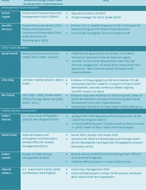
The SAMP’s iterative, coupled research‐and‐stakeholder process was as much a social process as a planning exercise, turning a diverse array of participants into MSP practitioners. Ocean SAMP practitioners included not only the lead planning agency but other state and federal agencies, commercial and recreational fishermen, boaters, divers, renewable energy developers, environmental organizations, the Narragansett Indian Tribe, and private citizens, including residents of Block Island and other adjacent coastal communities. Each made unique contributions to the Ocean SAMP development, bringing their individual skills and expertise to the process.
When the Ocean SAMP process shifted from plan development to implementation, the roles of these diverse practitioners changed. The lead regulatory agency, the Rhode Island Coastal Resources Management Council (CRMC), began formal application of the policies included in the plan. Stakeholders, such as fishermen and environmental organizations, began
a
URI Coastal Resources Center/Rhode Island Sea Grant, January 2016 4 to leverage relationships and reputations developed through the SAMP process to accomplish their own goals – a form of informal SAMP implementation. Although different entities have applied the Ocean SAMP in different ways, all of these uses can be considered under a broad umbrella of MSP implementation.
As noted earlier, this case study places particular emphasis on examining the formal and informal implementation of the plan from 2010 to 2015. (For further discussion of Ocean SAMP development, see McCann et al. (2013) and Olsen et al. (2014)). It is built on semi‐structured interviews with 17 key participants who have been involved in Ocean SAMP development and/or implementation (see Table 1). Ocean SAMP leaders assisted in identifying these
participants using a selection process that ensured each different sector, agency or organization was represented. Invited participants included commercial fishermen, with a wide range of viewpoints regarding the Ocean SAMP, although some were either unavailable within the project timeframe or declined to participate.
URI Coastal Resources Center/Rhode Island Sea Grant, January 2016 5
Fisheries and Aquaculture Coordinator with CRMC; formerly RI Sea Grant Fisheries Extension Agent Member of core SAMP development team who led
fisheries engagement; reviewed Block Island Wind Farm application; leads fisheries aspects of Ocean SAMP implementation
Independent facilitator of Ocean SAMP stakeholder group
URI Coastal Resources Center/Rhode Island Sea Grant, January 2016 6
Fisheries Biologist, NMFS Habitat Conservation Division Primary NMFS participant in Ocean SAMP process
Former commercial fisherman, marine safety instructor, and Vice President of CFRF
Deepwater Wind, LLC (DWW) Vice President of Permitting/Environmental Affairs
A DWW staff participant in SAMP process; oversaw DWW’s
Independent contractor Social scientist and marine governance professional Conducted first biennial Ocean SAMP assessment (2013)
URI Coastal Resources Center/Rhode Island Sea Grant, January 2016 7 The Ocean SAMP story begins in 2006, the year Rhode Island first formally committed to pursuing offshore wind energy. The text that follows describes the Ocean SAMP development and implementation activities, lessons learned, and how those lessons were made evident through the SAMP process.
II. Developing the Ocean SAMP
A. Background: Winds of Change off Rhode Island’s Coast
On January 12, 2006, Rhode Island Governor Donald Carcieri announced his aspiration to tackle the state’s rising greenhouse gas emissions and energy costs. By 2011, he declared, the state would aim to obtain 15 percent of its electrical supply from the wind.4 "I think this is something we can achieve, and I'm going to pursue this aggressively," he asserted
enthusiastically at a news conference.5 The governor’s commitment to wind energy was clear, and his timeline was ambitious.
A study funded by the then newly‐created Rhode Island Office of Energy Resources (OER) revealed that the only way to meet the governor’s renewable energy goal would be to take advantage of the Ocean State’s biggest asset: its offshore waters. That study, known as RIWINDS, estimated that 95 percent of Rhode Island’s wind supply lay offshore.6 With support and seed money from the governor, in 2007, the University of Rhode Island (URI) created a Center for Excellence for Research in Offshore Renewable Energy at URI’s Graduate School of Oceanography. This center was led by Rear Admiral Sam DeBow, retired from the National Oceanic and Atmospheric Administration (NOAA) Commissioned Corps, who had served aboard NOAA’s hydrographic survey ships during his seafaring career. The new center would take charge of developing an environmental impact statement (EIS) for a proposed offshore wind farm southeast of Block Island straddling state and federal waters. By early 2008, the state of Rhode Island had issued a Request for Proposals to identify a preferred offshore wind energy developer. Soon thereafter, Governor Carcieri was in conversations with Deepwater Wind, who had been selected as the state’s “preferred developer.”b
The governor’s intention to develop offshore wind energy could have moved ahead without a comprehensive planning process such as the Ocean SAMP. In fact, some interview participants believe it probably would have moved ahead without such a process in place were it not for the idea proposed by a longtime custodian of the state’s coastal resources, CRMC Executive Director Grover Fugate. The idea of what became known as the Ocean SAMP, a
b
URI Coastal Resources Center/Rhode Island Sea Grant, January 2016 8 marine spatial plan to guide the siting of offshore renewable energy, was ultimately supported at the highest levels of Rhode Island state government and URI leadership.
Fugate knew from his 28 years at the helm of CRMC that big gaps in knowledge existed about Rhode Island’s offshore environment. Biological and geological data were scarce,
centralized information about current users was limited, and the public had little in the way of a
stakeholder input for siting and permitting renewable energy and other permanent structures in marine waters.
Fugate, together with URI ocean engineer Dr. Malcolm Spaulding, argued to the RI OER that a proactive science‐based planning approach would be far more effective for ultimately siting and permitting an offshore renewable energy project. These and other SAMP proponents within state government and at the university argued that a SAMP could also streamline the
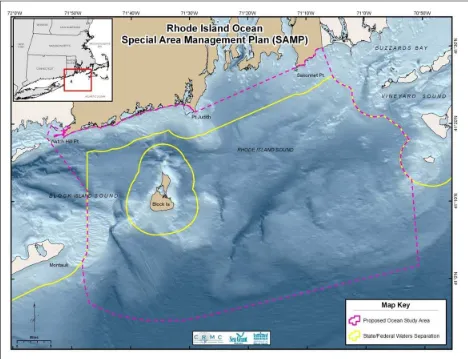
URI Coastal Resources Center/Rhode Island Sea Grant, January 2016 9
Figure 1. Ocean SAMP Planning Area Boundary (Source: CRMC/URI)
B. The Helping Hand of History
The move to pursue offshore planning in Rhode Island was a seed that fell on fertile soil. The wind energy imperative provided a strong driver: it shepherded resources, assured forward momentum within a tight timeline, and secured political and financial support from the highest offices of state government. Yet, interview participants point out that this seed of public
interest may not have flourished as it did, were it not for contextual factors that made Rhode Island a rich setting for an expansive MSP effort. This role of context and history is arguably critical for understanding Rhode Island’s experience with the Ocean SAMP.
URI Coastal Resources Center/Rhode Island Sea Grant, January 2016 10 the first decade after its 1971 creation, CRMC relied upon a piecemeal permitting system characterized by inefficiencies, inconsistencies, and accusations of political interference.7 During these years, CRMC and CRC established a partnership that would grow and strengthen over subsequent decades and through which CRC staff would help CRMC develop and refine its coastal management plan. After the first decade of this CRMC‐CRC collaboration, and three versions of a state coastal management plan, in the early 1980s, the two organizations
introduced two major new planning strategies in order to find a balance between issue‐driven planning and policy consultation and public consultation. One strategy was a comprehensive zoning plan assigning six different levels of usage and protection for Rhode Island’s coastal waters. The second strategy was to develop SAMPs for areas where complex environments, overlapping jurisdictions, and multiple human uses called for more focused analysis and
extensive public input processes. The conceptual framework for SAMPs is contained within the federal Coastal Zone Management Act (CZMA), which recommends special area management planning as a comprehensive tool for the protection of natural resources and promotion of appropriate development within specific areas of a state’s coastal zone (see Appendix I). CRMC and CRC took this conceptual framework and created a method of developing SAMPs that featured this agency‐university partnership and an intensive and collaborative stakeholder process.
CRMC completed its first SAMP, for the Providence Harbor, in 1983. By the time it embarked on the Ocean SAMP, it had completed five other SAMPs and had one more in progress (see Table 2). Throughout this time, CRMC’s Council, comprising appointed representatives who oversee the agency and approve planning and regulatory decisions,
actively engaged in and supported the development and use of SAMPs. As a result, when CRMC took on the Ocean SAMP, it brought with it a long history of institutional knowledge,
relationships with other agencies and stakeholders, and, according to interview participants, a reputation of capability.
URI Coastal Resources Center/Rhode Island Sea Grant, January 2016 11
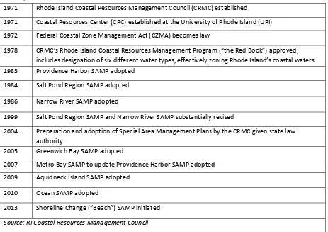
Table 2. History of Rhode Island Special Area Management Plans (SAMPs) and Coastal Management Accomplishments
1971 Rhode Island Coastal Resources Management Council (CRMC) established
1971 Coastal Resources Center (CRC) established at the University of Rhode Island (URI)
1972 Federal Coastal Zone Management Act (CZMA) becomes law
1978 CRMC’s Rhode Island Coastal Resources Management Program (“the Red Book”) approved; includes designation of six different water types, effectively zoning Rhode Island’s coastal waters
1983 Providence Harbor SAMP adopted
1984 Salt Pond Region SAMP adopted
1986 Narrow River SAMP adopted
1999 Salt Pond Region SAMP and Narrow River SAMP substantially revised
2004 Preparation and adoption of Special Area Management Plans by the CRMC given state law authority
2005 Greenwich Bay SAMP adopted
2007 Metro Bay SAMP to update Providence Harbor SAMP adopted
2009 Aquidneck Island SAMP adopted
2010 Ocean SAMP adopted
2013 Shoreline Change (“Beach”) SAMP initiated
Source: RI Coastal Resources Management Council
Although CRMC was experienced in marine spatial planning at the time it began the Ocean SAMP, Fugate notes that the Ocean SAMP was by far its most ambitious planning exercise to date. To pull it off, CRMC drew on a longstanding partnership with URI, particularly CRC and the Rhode Island Sea Grant College Program. Jennifer McCann, Director of U.S.
Programs at CRC and Director of Extension at the RI Sea Grant College Program, explained how CRC played a key role in shaping CRMC and its coastal management program for many years following its 1971 founding. In the 1970s, CRC often served as CRMC staff, and since then has collaborated closely with CRMC on all SAMPs and numerous other coastal management projects. Through this partnership, CRMC had developed working relationships with other URI scientists. By the time the Ocean SAMP was ready to be developed, this history of collaboration between CRMC, CRC, and the broader URI community provided a strong foundation of trust and familiarity that facilitated an efficient and consistent planning and research process shaped by goals widely seen as attainable despite their ambitious timeline.
URI Coastal Resources Center/Rhode Island Sea Grant, January 2016 12 miscommunication. We probably wouldn’t have been able to be so creative; it would have been a much more rigid process. We always said we were building the plane as we were flying it. And that’s really hard to do with a co‐pilot that you don’t know . . . I think it wouldn’t have been such a comprehensive or responsive project. We would have had to learn each other’s priorities. CRMC trusted our ability to do a public process [while CRMC controlled the policy process] . . . we knew each other so well that we were able to show each other our
vulnerabilities. That made it a more impactful process, because of that history.”
C. From Concept to Action
It was strong support at the highest levels of state government combined with URI leadership that moved the Ocean SAMP from idea to reality. When CRMC and the URI/CRC team presented the initial Ocean SAMP proposal in May 2008, Governor Carcieri quickly supported the project. Just three months later, the Rhode Island OER had supplied an initial $3.2 million to start the project via the Rhode Island Renewable Energy Fund, with the
understanding that a plan would be completed in two years. While the team had requested $6 million, including funds to build a meteorological tower, this lesser amount of funding was enough to jumpstart the SAMP process. And, less than a year later, the state provided an additional $2.8 million to support SAMP development and research.8 With this critical top‐level support, the Ocean SAMP became a foundation for the state’s offshore wind development strategy.
URI Coastal Resources Center/Rhode Island Sea Grant, January 2016 13
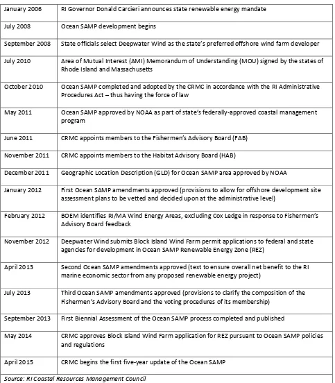
Table 3. Timeline: Key Events in Ocean SAMP Development and Implementation
January 2006 RI Governor Donald Carcieri announces state renewable energy mandate
July 2008 Ocean SAMP development begins
September 2008 State officials select Deepwater Wind as the state’s preferred offshore wind farm developer
January 2012 First Ocean SAMP amendments approved (provisions to allow for offshore development site assessment plans to be vetted and decided upon at the administrative level) marine economic sector from any proposed renewable energy project)
July 2013 Third Ocean SAMP amendments approved (provisions to clarify the composition of the Fishermen’s Advisory Board and the voting procedures of its membership)
September 2013 First Biennial Assessment of the Ocean SAMP process completed and published
Source: RI Coastal Resources Management Council
URI Coastal Resources Center/Rhode Island Sea Grant, January 2016 14 An intensive planning process unfolded over the next two years. CRMC and CRC
assembled a project management team comprising CRMC, CRC, and URI administrators and scientists. The management team’s purpose was to meet weekly and keep the entire research, stakeholder and policy development process moving forward. Additionally, they convened five advisory committees: a legal committee, scientific committee, stakeholder committee, state agencies committee (including representatives from Connecticut, Massachusetts, and New York), and a federal agency committee. They brought in an external volunteer facilitator, Ken Payne, to chair the stakeholder committee, and recruited 50 organizations and the general public to participate in the process. They formed Technical Advisory Committees (TACs) made up of scientific and stakeholder experts in their fields to help write and advise on each chapter. Over the course of the two‐year Ocean SAMP development process, the team held over 100 formal public meetings – including stakeholder meetings, TAC meetings, and CRMC Council meetings and hearings. This figure does not include the countless informal meetings and interactions between the Ocean SAMP team and stakeholders and experts.
The stakeholder process stands out as the central feature of the overall Ocean SAMP process and one that, according to interview participants, has given it lasting relevance. Interview participants explain how the stakeholder chair and management team designed the process to emphasize consistency of message (most meetings began with restating the SAMP goals, included in Appendix II); transparency (the leadership team let stakeholders see how decisions were made); and responsiveness of the process to stakeholder demands (e.g., the team granted a stakeholder organization’s request that each individual chapter, as well as the document in its entirety, be given a full review and public hearing by the CRMC). Participants also had their individual motivations for participating in the SAMP, and these varied widely (see the following box). This diversity of perspectives and motivations knit the process together and made for a stronger planning document in the end – one relevant to many different
stakeholders and, as such, likely to be actively used long into the future.
URI Coastal Resources Center/Rhode Island Sea Grant, January 2016 15 meetings, reading documents, and formulating suggestions. In these individuals’ own words:
liaison between the Block Island government entity and citizens, participated in meetings, and my background is in biology, so I had a personal interest as well.” surrounding competition over use of the waterways.”
fishermen, professional mariners, and recreational boaters and sailors. Interview participants emphasized that fishermen’s participation in the Ocean SAMP development and
URI Coastal Resources Center/Rhode Island Sea Grant, January 2016 16 share proprietary business information about the locations of their fishing activity have added a great deal of complexity to their participation in the Ocean SAMP process from the start.
Interview participants described how, in the early months of the process, large numbers of fishermen attended SAMP stakeholder meetings and were very vocal, expressing concerns about the potential impacts of offshore wind on their livelihoods and the possibility that the SAMP would add a new layer of regulations to already heavily‐regulated fisheries. Many fishermen conveyed their distrust of government, particularly acute in this case given that Rhode Island fishermen had not previously worked with CRMC, the state’s coastal management agency (the state’s fisheries are managed by a separate agency, the Department of
Environmental Management). To respond to this, Ocean SAMP leaders sought to maximize fishermen’s participation and access to information in every way possible. This included convening numerous targeted stakeholder meetings solely for fishermen; providing them with access to specialized maps, charts, studies, and offshore wind farm experts; and even
facilitating direct communication between fishermen and the state’s chosen offshore wind farm developer.
While the stakeholder process was underway, URI researchers, coordinated by ocean engineer Dr. Malcolm Spaulding, Sam DeBow and other URI leaders, identified and worked to complete numerous research projects to fill data gaps concerning the SAMP area. Research leaders selected priorities by considering existing CRMC SAMPs, the types of data used to inform the Cape Wind EIS, and URI scientists’ knowledge base of the offshore environment. Researchers investigated topics as wide‐ranging as geology, phytoplankton productivity, sea birds, underwater archaeology, geographical spread of commercial and sports fishing activities, location and timing of boating and other recreational uses, legal research on policies applicable to the SAMP area, and models of meteorological, acoustic, and wave environments. Most of this research was conducted or managed by university scientists and funded through public funds allocated for SAMP development.
Several interview participants emphasized that one very important research project was the Technology Development Index (TDI), developed by a team led by Dr. Malcolm Spaulding.9 The TDI was developed especially for the Ocean SAMP and applied to the Ocean SAMP area to help identify sites for potential offshore renewable energy development, and was used to help identify the Renewable Energy Zone (REZ) (see further discussion below). The TDI method quantified the “Technical Challenge” of developing a facility at a given location, taking into account construction challenges, expenses, and proximity to the energy grid, as well as the potential benefits of development (determined by assessing “Power Production Potential”). Sites with the lowest TDI (calculated by dividing the Technical Challenge by the Power
URI Coastal Resources Center/Rhode Island Sea Grant, January 2016 17 most desirable for development.10 Interview participants explained how the TDI, which
included numerous graphics and maps illustrating different datasets and different stages of the analysis, was foundational to the SAMP – both the research findings themselves as well as the graphics and the process. Some interview participants noted that the TDI enhanced stakeholder communication and understanding of the MSP process. At the same time, others felt it caused some stakeholders to see the Ocean SAMP as a narrowly‐focused renewable energy siting plan – which was not planners’ intention. Ocean SAMP leaders sought to address such concerns through the stakeholder process.
The process of writing the Ocean SAMP document involved extensive back‐and‐forth between the TACs, the SAMP management team, and stakeholder groups. The integrated writing process brought researchers and stakeholders into a collaborative, integrated
knowledge‐generation effort designed to produce more accurate and credible data than any individual group could have produced alone. Through a series of public workshops and formal CRMC public hearings, practitioners evaluated each chapter independently and then evaluated the SAMP document in its entirety, in order to apply an ecosystem‐based management lens to the whole plan (see Appendix III). This CRMC public comment process generated 2,000
individual comments, each of which CRC staff addressed or incorporated into the plan before it was finalized.
The 1,027‐page planning document produced through this process includes a synthesis of detailed data and information, findings of fact, general policies and enforceable regulations, and is accompanied by 2,827 pages of technical documents (included in Ocean SAMP Volume 2). Some chapters provide an in‐depth examination of commercial fisheries, recreational uses, and shipping while others summarize available knowledge of the ecology of the area, cultural and historic resources, and the prospect of offshore renewable energy and other future uses. A Narragansett Indian Tribe medicine woman and oral historian, Dr. Ella Wilcox‐Thomas Sekatau, contributed a tribal oral history, which is included verbatim in the plan’s chapter on cultural and historic resources. Interview participants explained that SAMP data and information included in these chapters was viewed as high‐quality and legitimate because it was part of a state‐ and university‐led MSP exercise, not part of a developer‐led exercise or a narrowly‐focused renewable energy siting effort.
The Ocean SAMP document included numerous new policies and regulations. These anticipate future development and new uses in the SAMP area and establish a number of mechanisms to balance these new activities with existing uses and ecological protection. The Ocean SAMP’s most innovative policies include:
URI Coastal Resources Center/Rhode Island Sea Grant, January 2016 18
A new regulatory process for evaluating applications to develop offshore renewable energy;
New mechanisms to facilitate continued stakeholder engagement through a Fishermen’s Advisory Board (FAB) and Habitat Advisory Board (HAB); Block Island, designated for potential offshore renewable energy development. This area was identified through the Ocean SAMP’s stakeholder process and through the many
features; areas of high natural productivity; areas with features of historical significance or cultural value; areas of substantial recreational value; areas important for navigation, transportation, and military uses; and areas of high fishing activity. Proposed development in APCs is subject to rigorous performance standards.
Areas Designated for Preservation (ADP): A series of areas designated in state waters for preservation due to their ecological value. Sea duck foraging habitats in waters less than 20 meters deep were designated as ADPs. ADPs receive a higher level of protection than APCs: most large‐scale offshore development projects are largely prohibited in these areas.
(Source: RI CRMC 2010)
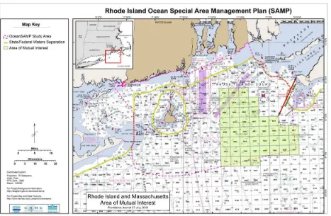
URI Coastal Resources Center/Rhode Island Sea Grant, January 2016 19 CRMC then took three different actions to institutionalize the plan in order to prepare for successful implementation. The first was to forge a formal agreement with Massachusetts. Near the end of the Ocean SAMP development process, the governors of Rhode Island and Massachusetts signed an agreement identifying an area of mutual interest (AMI) in federal waters adjacent to both states’ waters. A map of this area was added to the Ocean SAMP as a finding. The agreement designated the Ocean SAMP as the governing document for the AMI area for both states.
The second action was to work with NOAA to achieve two critical approvals. First, NOAA’s Office for Coastal Management (OCM) approved the SAMP as part of Rhode Island’s federally approved coastal zone management program in May 2011.11 Later that year, CRMC also requested NOAA approval for a Geographic Location Description (GLD) in the federal waters of the Ocean SAMP area. This ensures that Ocean SAMP information and policies are applied through future CRMC federal consistency review of any federal activity or federally‐ approved project in this area. NOAA approved the GLD in December 2011.
The third action was to ensure formal recognition from the Federal Energy Regulatory Commission (FERC). FERC officially recognized the Ocean SAMP in May 2012 as a
“comprehensive plan,” meaning the agency would consider the SAMP when reviewing and permitting future renewable energy projects.e
Many lessons learned emerged through the SAMP development phase. These are discussed in the final pages of this case study, as are the lessons learned during the implementation phase – for as mentioned earlier, the two phases build from each other. Considering what has been learned at the different stages of the overall process also helps in understanding the “whole” of the Ocean SAMP and how what happened in the development phase in many cases either shaped or influenced what happened in the implementation phase.
III. Ocean SAMP Implementation
After CRMC formally approved the Ocean SAMP document in 2010, participants’ level of energy and direction of effort changed. The intensive two‐year process of developing the plan had been a centralized effort, where all participants – CRMC, CRC, scientists, and stakeholders – combined efforts towards a single shared goal: development of a marine spatial plan for the waters off Rhode Island. After SAMP approval, that team effort entered a more decentralized
e
URI Coastal Resources Center/Rhode Island Sea Grant, January 2016 20 phase in which the various products of the Ocean SAMP – new knowledge, new relationships, new policies and regulations – were filtered into many different decision‐making arenas.
This section presents initial observations, reflections, and analysis from the Ocean SAMP implementation phase. At the time of this writing, the Ocean SAMP has been in
implementation (post‐plan approval) for five years. Observations and analysis of those five years follow, while lessons learned are included in Section IV, which captures key lessons from both the development and implementation phases of the Ocean SAMP process.
For the purposes of this analysis, Ocean SAMP implementation includes top‐down implementation by CRMC, bottom‐up implementation by fishermen and environmental stakeholders, and lateral implementation by other agencies involved in permitting decisions in the SAMP area. Additionally, implementation encompasses both formal execution of
procedures laid out in the Ocean SAMP document as well as various forms of informal
implementation. Examples of informal implementation include usage of data produced in the SAMP process, further strengthening of or tapping into relationships developed during the process, or informal information‐sharing amongst participants – all for purposes other than formal permitting activities. Interviews indicate that these informal aspects are, in fact, some of the most important ways in which the Ocean SAMP has become a tool for achieving results.
A. Implementing the REZ: Permitting the Block Island Wind Farm
The first formal use of Ocean SAMP regulations took place in the context of Deepwater Wind’s proposal to build a 30‐megwatt facility three miles southeast of Block Island, in the REZ. Submitted in September 2012, the proposal included five turbines, a cable connecting the turbines to Block Island, and a second bi‐directional cable connecting Block Island with the mainland.12 Deepwater Wind worked with Ocean SAMP data and within Ocean SAMP policies in its permit applications, its construction and operations plan, and its siting decisions, perhaps most significantly in its use of the REZ. “The Renewable Energy Zone was a real positive for us in terms of taking the issue of siting off the table,” said Aileen Kenney, Vice President of
Permitting for Deepwater Wind. “The process found the site, and then we have to be within it, so it helped the permitting process to go smoother than it might have without the Renewable Energy Zone.”
URI Coastal Resources Center/Rhode Island Sea Grant, January 2016 21 – for example, utilizing Ocean SAMP data or drawing on improved personal knowledge formed during the Ocean SAMP development phase.
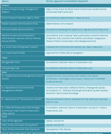
Wind farm permits and reviews were issued by multiple state and federal agencies (see Table 4). These included a permit (called an “assent”) and submerged lands lease issued by CRMC in November 2014. These also included an Individual Permit from the U.S. Army Corps of Engineers under the federal Rivers and Harbors Act and Clean Water Act (September 2014), and a Right of Way Grant from BOEM to lay the cable that would cross federal waters (November 2014).13 Other agencies, such as the U.S. Fish and Wildlife Service, the U.S. Coast Guard (USCG), and the NOAA National Marine Fisheries Service (NMFS), played a role in reviewing the
proposal under the joint Environmental Assessment prepared by the lead agency, the U.S. Army Corps (USACE), and the cooperating agency (BOEM) pursuant to NEPA.
URI Coastal Resources Center/Rhode Island Sea Grant, January 2016 22
Table 4. Agencies Issuing Permits or Approvals for the Block Island Wind Farm
Agency Permit, Approval or Consultation Required
Environmental Protection Agency (EPA) Air Conformity Determination (Clean Air Act)
Federal Aviation Administration (FAA) Determination of No Hazard
Fish and Wildlife Service (USFWS) Consultation (Endangered Species Act, Migratory Bird Treaty Act)
National Oceanic and Atmospheric
Administration National Marine Fisheries
Service (NMFS)
Consultation and Incidental Take Authorization (Marine Mammal Protection Act); Essential Fish Habitat consultation (Magnuson‐ Stevens Fishery Conservation and Management Act)
U.S. Army Corps of Engineers (USACE) Individual Permit (Rivers and Harbors Act, Clean Water Act)
U.S. Coast Guard (USCG) Approval for Private Aids to Navigation
Tribal
Narragansett Tribe Consultation (National Historic Preservation Act)
Wampanoag Tribe Consultation (National Historic Preservation Act)
State
R.I. Coastal Resources Management Council
(CRMC)
Assent (Permit); Concurrence with Federal Consistency Certification; Submerged Lands Lease; Coastal and Freshwater Wetlands Permit
R.I. Department of Environmental
Management (RIDEM)
Coastal and Freshwater Wetlands Permit; Endangered Species Consultation; R.I. Pollution Discharge Elimination System General Permit for Storm Water Discharge
R.I. Department of Transportation (RIDOT) Physical Alteration Permit; Easement for the cable and overhead
electric lines
R.I. Historical Preservation and Heritage
Commission State Historic Preservation
Office (SHPO)
Consultation (National Historic Preservation Act and R.I. Historic Preservation Act)
Local
Town of Narragansett Special Use permit
Town of New Shoreham Zoning Board Special Use Permit
Town of New Shoreham Planning Board Development Plan Review
Source: Deepwater Wind. 2012. Block Island Wind Farm/Block Island Transmissions System Environmental Report/Construction and Operations Plan. Online at http://dwwind.com/wp‐
content/uploads/2014/08/Environmental‐Report.pdf.
URI Coastal Resources Center/Rhode Island Sea Grant, January 2016 23 Representatives of some permitting agencies interviewed for this case study indicated that the Ocean SAMP eased their respective permitting processes in several ways. The
proposed wind farm’s location within the REZ assured reviewers that the public had already vetted the location and was unlikely to raise major objections during the public comment process. Meanwhile, the wind farm location’s avoidance of APCs and ADPs designated through the SAMP assured reviewers that it would not interfere with sea duck foraging habitat, shipping lanes, or Navy testing ranges that would have been grounds to deny or challenge a permit. Moreover, the abundance of data contained within the Ocean SAMP, which had been produced by university scientists and scrutinized by a comprehensive group of stakeholders, provided a valuable and trusted informational resource.
Marine spatial planning is sometimes touted as a way to simplify the mandated NEPA environmental review process by generating enough up‐front information to eliminate the need for a full‐blown EIS, and this was one of the arguments originally used in presenting the idea of the Ocean SAMP to state leadership. In the case of the Block Island Wind Farm, USACE reviewer Bob DeSista estimated that the Ocean SAMP saved his agency two to three years by enabling the project to move ahead with the less time‐consuming and resource‐intensive option of an EIS, which resulted in a Finding of No Significant Impact.
USACE drew on the Ocean SAMP when developing alternative siting scenarios, a required step for NEPA analysis. It was not simply a coincidence that the Ocean SAMP contained ample information useful for this analysis. By participating in the Ocean SAMP development, USACE provided input that helped ensure that the plan generated the kind of data they would eventually need for their NEPA review, including the alternatives analysis the Corps would ultimately be required to perform. “They almost did some of the work for us before we had to do it,” observed DeSista. “There was a lot of information in there that we and other agencies who were commenting on it could utilize.”
Other agencies involved in the permitting process echoed DeSista’s observation, saying that the Ocean SAMP enabled them to review the project more swiftly and confidently. For example, Edward LeBlanc of the USCG noted that widespread references to Ocean SAMP data within Deepwater Wind’s navigational risk assessment greatly informed his agency’s review and evaluation of navigation risks. “We took that at face value,” said LeBlanc. “‘Oh, it’s in the
SAMP? Then fair enough, we’re moving on. We’re not questioning the methodology of how that document was prepared because we know it. We were part of it.’”
URI Coastal Resources Center/Rhode Island Sea Grant, January 2016 24 were provided within the requested timeline.”
In addition to facilitating agency decisions about whether to permit the wind farm, interview participants explained how the Ocean SAMP helped some agencies determine what conditions to place on the wind farm in their respective permits. For instance, CRMC worked closely with USACE, according to Bob DeSista, as they prepared their own permit in order to coordinate and create consistency between the two agencies’ monitoring requirements and decommissioning plans. NMFS fisheries biologist Sue Tuxbury explained how NMFS also worked with the state and USACE on overlapping monitoring requirements. For example, coordination among the state and federal agencies, as well as the fishing community, ensured a robust trawl survey was incorporated as a requirement in the federal permit.f
Interviews revealed the Block Island Wind Farm permitting process also benefited from the Ocean SAMP’s intangible outcomes, such as social capital. Most notably, working
URI Coastal Resources Center/Rhode Island Sea Grant, January 2016 25 there’s not a learning curve there really. They all obviously know what type of product we’re trying to sell, which is offshore wind, but they all also know each other. For example, the fishermen understand why the tribes are at the table, and they all understand why folks are concerned about marine mammals.”
Permitting the Block Island Wind Farm in the REZ relied on the Ocean SAMP in many ways – both the designated areas and regulations established by the SAMP, as well as the relationships and communication the SAMP established between agencies, stakeholders, and the developer. This stands in contrast to efforts to site another wind farm, Cape Wind,
discussed below.
URI Coastal Resources Center/Rhode Island Sea Grant, January 2016 26 Planning for Offshore Wind Development in New England:
Comparing Cape Wind and the Block Island Wind Farm
The Block Island Wind Farm permitting experience stands in stark contrast to the experience of the nearby Cape Wind project, proposed in 2001 in federal waters of Nantucket Sound.14 The Cape Wind project underwent 14 years of permitting battles and litigation, and at the time of this writing, appears to be all but permanently defeated. There are many reasons that Cape Wind faced a steeper battle than the Block Island Wind Farm. These include its much larger size at 130 turbines, its location in federal rather than state waters, early and intense opposition from a few influential and wealthy property owners, mid‐stream changes in the permitting process due to the Energy Policy Act of 2005, and open opposition from two out of the three governors who sat in office during the efforts to win approval and begin construction. However, interview participants who observed both processes say that some of the Block Island Wind Farm’s comparative success in obtaining necessary permits with minimal public opposition can be traced to the Ocean SAMP’s broad and proactive public planning process.
Unlike the Block Island Wind Farm, the Cape Wind project did not stand on the shoulders of a public MSP process, for no such process had been completed in the waters off Massachusetts at the time. Instead, the developer chose what appeared to be a suitable location and applied for a lease to use it – following the process that was required under existing federal
environmental regulations. As a result, Massachusetts lawyers Kenneth Kimmel and Dawn Stalenhoef wrote that the project was beset from the beginning by a public perception that “Cape Wind had simply located a site, staked a flag on it, as it were, and began permitting as if it had the necessary property rights.”15
The fundamental difference is that the Block Island Wind Farm was sited through a broad, state‐led, comprehensive planning process, whereas Cape Wind was sited through a narrowly‐ focused, developer‐driven permitting process. Whereas siting an offshore wind farm is neither an assumed goal of marine spatial planning nor an indicator of success per se, these two cases illustrate some of the potential benefits of undertaking a comprehensive, stakeholder‐driven MSP process.
B. Exerting the Influence of the Ocean SAMP Outside of State Waters
URI Coastal Resources Center/Rhode Island Sea Grant, January 2016 27 solid data and existing policy tools, is arguably beyond the norm for a state planning effort. Through the Ocean SAMP, the state of Rhode Island:
Secured NOAA approval of a GLD for state waters, giving CRMC increased federal consistency review authority over certain activities in federal waters;
Developed the AMI agreement with Massachusetts, collaborating rather than competing with its neighbor over development in adjacent federal waters;
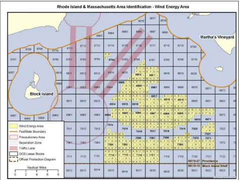
Drew on data and relationships formed through the Ocean SAMP to influence site selection of a set of BOEM lease blocks in federal waters; and,
Is playing a role in the anticipated development of an approximately 200‐turbine wind farm in the AMI area.
The influence that Rhode Island has achieved to date over federal waters through the Ocean SAMP shows that marine spatial planning can be a way for a state to influence activities outside its own waters, and in doing so achieve numerous environmental, economic and social benefits.
i. Expanding Rhode Island’s Influence in Federal Waters: Using the Ocean SAMP to Develop a GLD
SAMP leaders interviewed for this study explained CRMC’s early recognition that the Ocean SAMP would be a primary tool to address activities in federal waters, including energy projects, through the federal consistency provision of the federal CZMA and that the Ocean SAMP data and information would enhance the state’s ability to review these activities in federal waters. In addition, SAMP leaders explained how they envisioned the Ocean SAMP forming the basis for proposing to NOAA a GLD in federal waters for CRMC federal consistency reviews. Under NOAA’s CZMA regulations, a state can establish a GLD for an area outside of its coastal zone.g In a GLD, a state lists the federal licenses or permits for activities that will be automatically subject to state CZMA review. Otherwise, a state would have to request approval from NOAA to review proposed projects in federal waters on a case‐by‐case basis. Listed activities are those that have been found to have “reasonably foreseeable effects” on a state’s coastal uses or resources.
For Rhode Island, a GLD for the Ocean SAMP area would ensure that CRMC and Rhode Islanders would have a say in any new development proposed for the federal waters within the SAMP area (out to 30 miles, well beyond the three‐mile state waters boundary). SAMP leaders explained that by creating the GLD for review of projects in federal waters, CRMC ensured that
URI Coastal Resources Center/Rhode Island Sea Grant, January 2016 28 the Ocean SAMP information and policies would be applied through future CRMC federal consistency review of any federal agency activity or federally approved project proposed for state waters and federal waters within the GLD, conducted through CRMC’s coastal zone management authority. When a GLD is in place, the onus is on non‐federal applicants seeking a listed federal permit to file a federal consistency certification with the state coastal
management agency. This gives states more influence over the leasing and
permitting/authorization processes for these activities. Additionally, for listed activities in a GLD, the state does not need to track these activities off of its coast; rather, the burden is on the applicant and the authorizing agency to notify the state.h
CRMC requested approval of a GLD from the NOAA OCM in 2011. CRMC’s proposed GLD covered all federal waters within the SAMP area, and requested “listed” status for eight classes of activities: offshore renewable (wind, wave, tidal) energy, offshore liquefied natural gas (LNG) platforms, artificial reefs, underwater cables, mining activities, aquaculture, dredged material disposal, and meteorological towers. NOAA approved the GLD for seven of the eight proposed categories. It did not grant listed status for dredged material disposal because previous Army Corps monitoring of an existing dredge spoil disposal site, Area 69B, showed no evidence of adverse biological effects and, at the time of the GLD review process, CRMC was unable to produce enough data to satisfy NOAA’s requirements on this topic.
Having a marine spatial plan is not a prerequisite for a GLD, but extensive, high‐quality data is. A comprehensive, science‐based, and stakeholder‐driven MSP process is an effective and efficient way to generate this data. Data and reliable studies are what enable states to build persuasive “reasonably foreseeable effects” arguments necessary to convince federal authorities that the state should have review authority of, and therefore, greater influence over, listed activities in federal waters. To demonstrate that a class of federally permitted activities (e.g., wind energy, dredging) will have effects on uses or resources of the state’s coastal zone, states must use data about an area and its natural resources and human uses to demonstrate a causal relationship between activities in the GLD area and effects to uses or resources of a state’s coastal zone (even if the uses or resources occur or are affected in federal waters). Given this, the scientifically sound and extensive research performed by URI scientists was critical to CRMC in making successful coastal effects justification arguments for seven classes of activity. Without the Ocean SAMP funding, research and stakeholder involvement, it would arguably have been very difficult to develop the GLD.
h
URI Coastal Resources Center/Rhode Island Sea Grant, January 2016 29 Interviews revealed that the Ocean SAMP also supported Rhode Island’s GLD request in intangible ways by cultivating close working relationships with many of the federal agencies that would be affected by the GLD. By involving NOAA’s OCM (which approves changes to state coastal management programs, including GLDs) and other federal agencies with a say in
approving listed uses (e.g., USCG, USACE, BOEM, the Navy) early and often in the Ocean SAMP process, CRMC made sure these agencies not only fully absorbed the information generated through the process, but were able to provide input at every stage. This also resulted in the federal agencies signing off on the GLD in the end. Moreover, CRMC announced early on in the Ocean SAMP process that it intended to pursue the GLD, so when it finally did, the agencies with a say in its approval were not caught off guard. “As soon as we would draft a version [of the Ocean SAMP], we’d send it to [the federal agencies] for comments,” recalls CRMC Director Grover Fugate. “They’d send back the comments, we’d incorporate them, and send it back. It went back and forth like that. So NOAA had participated in the drafting of each of the chapters, and later with the GLD. They were intimately familiar with how everything was flowing.”
The GLD amplifies the impact of the Ocean SAMP in other ways as well. Fugate explained how the GLD amplifies the power of the FAB and the HAB established through the SAMP because these boards now “have standing with the federal agencies.” He explained how, in this sense, the GLD has “given the state more control over its destiny” by expanding its influence in federal waters. While there are few tangible effects of the GLD to date, Fugate explained how the FAB has already wielded some influence by helping to determine the
fisheries monitoring studies the agencies have required Deepwater Wind to perform, as well as the location of a proposed meteorological buoy. While other effects have not yet been
demonstrated in any measurable way, observers theorize that the benefits of the GLD have already played out in more subtle ways. “The leverage that it creates is influential,” observed CLF’s Tricia Jedele. “Just the fact that we have a GLD that’s been approved for a whole list of activities gives CRMC leverage when talking with the federal government before a project is proposed, when it’s just an idea.”
ii. The Area of Mutual Interest (AMI): Interstate Coordination and Influence over Federal Decisions
URI Coastal Resources Center/Rhode Island Sea Grant, January 2016 30 innovative tool to influence the siting of federally permitted wind energy projects.
institutionalizing elements of the Ocean SAMP. Mechanisms included:
costs and benefits resulting from wind energy, including associated infrastructure development, construction and operations jobs, payments to states associated with the federal lease,