BAGAMOYO GOVERNANCE BASELINE
This publication is available electronically on the Coastal Resources Center’s website at http://www.crc.uri.edu. It is also available on the Western Indian Ocean Marine Science Organization’s website: www.wiomsa.org. For more information contact: Coastal Resources Center, University of Rhode Island, Narragansett Bay Campus, South Ferry Road, Narragansett, Rhode Island 02882, USA. Tel: 401) 874-6224; Fax: 401) 789-4670; Email: [email protected]
Citation: Torell, Elin, Aviti Mmochi, and Penny Spierling, 2006, Bagamoyo Governance Baseline
Coastal Resources Center, University of Rhode Island. pp. 24
Disclaimer: This report was made possible by the generous support of the American people through the United States Agency for International Development (USAID). The contents are the responsibility of the authors and do not necessarily reflect the views of USAID or the United States Government. Cooperative agreement # EPP-A-00-04-00014-00
Cover Photo: Bagamoyo sand bank and ruins
Table of Contents
LIST OF TABLES ... 3
LIST OF FIGURES ... 3
HISTORY ... 4
TRENDS IN RESOURCE CONDITION AND USE... 4
FISHERIES... 5
THE CASE OF SHRIMP FISHERIES IN THE SAADANI VILLAGE ... 8
DEFORESTATION AND EROSION ... 9
SEAWEED CULTIVATION... 9
TOURISM ... 10
THE TRAJECTORY OF ICM IN BAGAMOYO ... 10
COLLABORATIVE FISHERIES MANAGEMENT ... 13
THE COASTAL MANAGEMENT PORTFOLIO ... 16
FIRST ORDER OUTCOME ASSESSMENT... 17
MANAGEMENT CAPACITY... 20
BIBLIOGRAPHY... 22
APPENDIX A. SUMMARY TIMELINE OF PRESSURE, STATE, AND RESPONSE IN BAGAMOYO... 23
APPENDIX B. ROLES AND RESPONSIBILITIES IN THE CFM ... 25
List of Tables
Table 1. Population and Fishers in the Coastal Villages of Bagamoyo ... 6Table 2. Fishing Methods and Gears Used in the Bagamoyo District ... 6
Table 3. The ICM Policy Process in Bagamoyo ... 11
Table 4. Results of the Ecological Assessment of Suggested CFM No-Take Areas... 13
Table 5. Selected No-Take Areas and Responsible Villages ... 14
Table 6. First Order Outcome Assessment ... 18
Table 7. Management Capacity... 20
List of Figures
Figure 1. Map of Tanzania and the Bagamoyo District... 5Figure 2. Artisanal Catch and Number of Licensed Fishers in Bagamoyo District ... 7
Figure 3. Bagamoyo ICM Cycles ……… 12
History
Once a center for the East African slave trade, Bagamoyo literally means, “lay your heart” (Bwaga = lay and Moyo = heart in Swahili). The name came from the despair felt by those who had been captured inland and transported to Bagamoyo where they waited to be shipped to Zanzibar and the Far East. Knowing that they would never see their homeland again, the saying goes that they left their hearts in the port-town, which therefore became known as Bagamoyo. During the Arab dominance, Muslim Arabs from Oman established several towns along the Tanzanian coastline and on nearby islands such as Pemba and Zanzibar. Coastal towns like Bagamoyo, developed into independent economic units owing varying degrees of allegiance to the sultan. There were
two social classes in the towns, the ruling Arab class and the African laboring class — of which the majority were slaves. The Arab merchants conducted a
profitable trade, exporting ivory, copper, gold, and slaves from the interior. During the over 1000-year Arab presence, they built mosques and other structures, still remaining in Bagamoyo today.
At the end of the Arab era, Missionaries started coming to Bagamoyo, where in 1868, the first East African church was constructed. This is where the body of Dr. Livingstone was kept while waiting to be transported back to Europe. Missionaries strongly opposed the Arabic social institution of slavery, and although they had little impact among African societies before the late 1800s, they laid the foundation for the future integration of the Tanzanian society with the West.
In the mid-1880s East Africa was divided between Great Britain and Germany. Germany ruled mainland Tanzania, or Tanganyika, until the end of World War I. During the German rule, Bagamoyo was the capital of Tanzania and the Germans built a number of colonial-headquarter buildings, which are still used by the district government. When the British took over in 1919, they moved the capital to Dar es Salaam and Bagamoyo turned into a small rural town. Today, Bagamoyo is once again growing, as the new highway from Dar es Salaam has made the commute to Dar es Salaam less than an hour, attracting both tourist investors and private homeowners.
T
RENDS INR
ESOURCEC
ONDITION ANDU
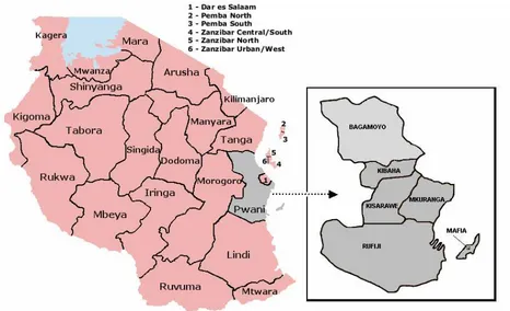
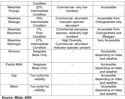
SEBagamoyo is a large district located just north of the Kibaha District and Dar es Salaam (Figure 1). The total population of the district is around 230,000 persons, with an annual growth rate of almost 2%. Bagamoyo is a relatively large district (almost 10,000 square kilometers) and it has 78 villages. There are 9 coastal villages and the Bagamoyo town, which recently became upgraded to a township.
The Kaole Ruins established in the 13th century
Figure 1. Map of Tanzania and the Bagamoyo District
F
ISHERIESThe nine coastal villages have around 650 small-scale fishers (Table 1). Artisanal fishing is by far the most important economic activity for the people in these villages and 70-80% of the men and women are to some extent involved in the fishing industry. Other occupations include boat building, salt making, charcoal making, mangrove pole cutting, seaweed
farming, house building, wage labour, livestock, and traditional medicine. Women traditionally play a role in fish processing and do little fishing individually. Their fishing includes collecting bi-valves and catching shrimp and fish with nets in shallow water.
1985 to 25kg in 2004. At the same time they noticed a decrease in fish size (pers. comm. Mlingotini fishers, January 2005). These are classic symptoms of unsustainable exploitation and over-fishing.
Table 1. Population and Fishers in the Coastal Villages of Bagamoyo
VILLAGE POPULATION NUMBER OF FISHERS
Dunda 9,720
-Magomeni Not Available Dunda and Magomeni
Combined = 180
Kaole 1,174 39
Pande Not Available 18
Mlingotini 2,164 150
Kondo 1,340 42
Mapinga Not Available 94
Buyuni 210 Not available
Saadani 1,491 100 (shrimp fishers)
Source: Bagamoyo District Natural Resource Office, 2005 and PEACE PRA Report
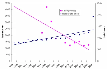
Along with the upsurge in the number of fishers, the number of traditional vessels in the district has increased from 120 in 1996 to 368 in 2005. Vessels used in Bagamoyo are dhows, boats, and outrigger canoes. Very few boats are motorized and most use sails for propulsion. At the market, on average, fishers sell their catch for approximately 1,200 Tsh per kilogram. This is the same price that fishers receive for cultured milkfish in Mkuranga.
Table 2. Fishing Methods and Gears Used in the Bagamoyo District
TYPES OF GEARS USED NUMBER OF GEARS
Long Lines 5580
Beach Seine 73
Hand Lines 2119
Fish Traps 54
Gill Nets 2000
TOTAL 9826
Source: Bagamoyo District Natural Resource Office, 2005
Nationally, the industrial trawling effort has increased progressively from 12 vessels in 1988 to 25 vessels in 2005 (District Fisheries Statistics). The marine area off the Bagamoyo District is one of the prime trawling grounds in the country. The industrial fish by-catch has also increased to 862 tons annually in the Bagamoyo District. This means that today, the trawlers end up selling more finfish than shrimp, which is the species that they target (Fisheries Department Statistics).
companies from small scale artisanal fishers — and from the district to the national government
.
Figure 2. Artisanal Catch and Number of Licensed Fishers in Bagamoyo District
Source: Bagamoyo District Natural Resource Office, 2005
Due to the large trawling effort, the annual prawn production is twice as large as the scientifically recommended carrying capacity. The trawling fleet is also twice as large as it needs to be, meaning that even if the number of vessels were halved, they could still catch the same amount of prawns that the current fleet catches. This over harvesting is evidenced by the declining catch per unit effort
(CPUE) and the size decrease in prawns (Lemma 2003). The increase in trawl fishing in the mid-1980’s coincided with artisanal fishers reports that finfish
catches had started to decline. This indicates an allocation issue, where the artisanal catches have declined while the overall trawl catch increased.
Destructive fishing is practiced on Bagamoyo’s coral reefs. In the 1980’s and 1990’s, dynamite fishing was out of control with blasts occurring two times per day. Currently, dynamite fishing seems to be declining in Bagamoyo area. Some
Fisher with small mesh seine net
Marin
e
Parks and Re
se
rve
say that the decline can be attributed to the awareness raising efforts that have taken place through the district ICM process. But dynamiting is still a problem, with blasts heard
approximately once a week (District Fisheries Statistics). Reef surveys have shown that the coral habitat continues to decline on the reefs off of Bagamoyo. Recent community coral reef monitoring reveals that some reefs have as little as 3% live hard coral cover (Table 4) and as much as 80% rubble due to destructive dynamite fishing (Community Based Ecological Monitoring Report, 2005). In addition, the use of fine mesh nets has increased. Since the 1980’s, the number of fishers using beach seine nets as their primary gear has steadily increased. In 1990, 436 fishers were beach seining and in 2004 that number had risen to 523 (District Fisheries Statistics).
The use of fine mesh nets causes an increasing catch of small juvenile fish. Dynamite fishing combined with the use of fine mesh nets are exacerbating the over-fishing problem.
T
HEC
ASE OFS
HRIMPF
ISHERIES IN THES
AADANIV
ILLAGEArtisanal shrimping is the primary fishery in the Saadani village, involving about 100 men and women. The involvement of women in the shrimp fishery is a relatively recent change, but it is culturally acceptable since it is done from the shore. Normally there are two fishing seasons - the high season for shrimp is from March to May (Kusi) and the short season is from October to November (Maleleji). These harvesting seasons attract migrants from surrounding villages as well as urban areas. There is less fishing activity between June and September (Parataza/Kusi) and between December and February (Kaskazi).
Fishers use seine nets and fish at low tide standing in the water up to their chest. Men are largely responsible for the fishing gear, but do not necessarily own it outright. In many cases, a particular buyer gives the gear to individual fishers. When business people come to the village during the harvesting season, they distribute the fishing gear (nets) to individuals (women can also receive nets) on condition that all the shrimp caught will be sold to them – a practices similar to that used by the seaweed industry. The nets are given on a seasonal basis and can be used for up to one year. This system gives the buyer more power to set the price of the catch. The businessmen transport the shrimp in iceboxes by boat or road and market them in surrounding districts, Dar es Salaam and Zanzibar.
The reasons given for the decreasing catch include the presence of more fishers and commercial shrimp trawlers that come to the area during the season from the port of Dar es Salaam. When a trawler finds an abundance of shrimp in one location it will radio other boats owned by the same company. Boats might travel all the way from Mafia Island to take
advantage of the good catch. According to key informants, an agreement was reached last year between the district and national government authorities to prohibit trawler fishing from March to May, the critical fishing period for artisanal fishers. This agreement is a result of negotiations held as part of the district action planning process.
D
EFORESTATION ANDE
ROSIONMangroves grow along the flats between coastal villages and the shore. Mangrove resources have been protected in Tanzania ever since 1898 when the
German administration established a mangrove management ordinance. The British subsequently
expanded the mangrove reserves to cover 80,000 hectares on the mainland. After independence, the Tanzanian government continued to protect mangroves as territorial forest reserves. However, the reserves were neither managed nor enforced. In 1987, the Director of Forestry imposed a national ban on the cutting of mangroves, pending the preparation of a mangrove management plan, which was approved in 1994. Through this plan, all
mangroves in Tanzania are protected through a national zoning scheme. The actual zoning of existing mangrove areas is still going on.
According to the zoning scheme, villagers are not allowed to cut mangroves or litter in mangrove areas. Overall in Tanzania, the mangrove resources seem to be relatively stable and in some places the mangrove cover is even expanding (Wang et al. 2005). But in areas of Bagamoyo, uncontrolled cutting is still a problem. In some places the beach has receded considerably as a result of lost mangroves and protection from erosion has since decreased. People cut mangroves for fuel wood and charcoal production. Some of the fuel wood is consumed locally, but there is also a great demand from Zanzibar. Even though export of wood and charcoal is illegal, there is a profitable underground trade. Tourism also
contributes to mangrove destruction in the coastal area around Bagamoyo town. Hotel owners, who are usually aware that mangroves are protected, remove mangroves to make the beachfront more appealing to tourists. In some villages salt making is the activity most responsible for the destruction of the mangroves. While women are responsible for the collection of fuelwood for household use (and may sell small amounts of surplus wood within the village) charcoal production and sale is largely a male-dominated activity.
S
EAWEEDC
ULTIVATIONPeople have harvested native seaweed species from the intertidal zone in Tanzania since the 1950s. They collected both Eucheuma spinosum (a native E. spinosum species) and
Kappaphycus striatum (a native K.alverazii species), which are relatively abundant along Tanzania’s coastline (Jaasund, 1976; Mshigeni, 1973). Although no data was collected on the seaweed harvesting activities at that time, it is estimated that production was in the range of 400 to 800 tones per year. In 1982, Prof. Mshigeni of the University of Dar es Salaam
Coastal erosion in Bagamoyo
introduced the idea of seaweed farming in Tanzania. His idea was to supplement the wild stock, thereby improving production; particularly focusing on seaweed quality and quantity. In the mid 1990s, mainland villages stared farming seaweed for commercial purposes, first in Muheza and Pangani, and later in other areas. Commercial seaweed cultivation came to Bagamoyo in 1998. Using two exotic strains of K.alverazii and E. spinosum, seaweed is cultivated using farming techniques adapted from the Philippines.
Today, small-scale seaweed farming is one of the most important socio-economic activities along Tanzania’s coast, providing employment opportunities and cash earnings, especially for women. In Bagamoyo, seaweed farming is a growing important economic activity for women. Through the Sustainable Coastal Communities and Ecosystems program (SUCCESS), over 100 women and men, from four villages (Mlingotini, Kondo, Pande and Changwahela) are involved in seaweed farming in Bagamoyo. In Mlingotini, which was the first village to grow seaweed in Bagamoyo, villagers are primarily growing K. alverazii. In 2003-2004, the villagers
experienced a seaweed die-off. That is one reason why they were interested in participating in the SUCCESS program’s piloting of alternative methods for seaweed cultivation that are expected to reduce the die off problem.
T
OURISMWhen tourists consider going to Tanzania, they are likely attracted to the thought of climbing Kilimanjaro, visiting one of the large inland parks like Serengeti, or lounging on the beaches on Zanzibar. However, recently Bagamoyo has also sprung up as a potential tourist
destination. The reasons are several – for one, the new road from Dar es Salaam has now made access easier. The first hotel was built in Bagamoyo in 1993 and the tourism growth was slow for about ten years. But since the new road was finalized in 2003, the number of hotels has expanded from four to eight. It is expected that city dwellers increasingly will make Bagamoyo a weekend destination. Recently, Bagamoyo was named a world heritage site because of its historical prominence and the Saadani Game Reserve was upgraded to a national park in 2005. Both these events are expected to inspire more tourism to the district. Today, there are only two tourist lodges adjacent to the park on the Bagamoyo side (the Park extends over three districts: Bagamoyo, Pangani, and Handeni), but the number of hotels is expected to increase in the near future.
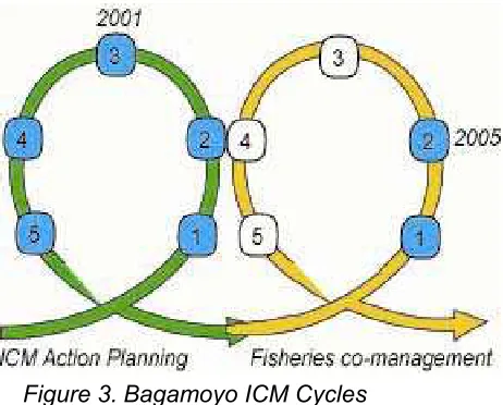
The Trajectory of ICM in Bagamoyo
The Bagamoyo district has completed one ICM Policy Cycle through its district action planning process. Currently the district is in a second cycle, having recently developed a collaborative fisheries management (CFM) plan for seven of the nine coastal villages.
In 2002, the Cabinet approved the National Integrated Coastal Environment Management Strategy. Through this strategy, Tanzania has committed to support integrated planning of coastal resources and activities at the local level and to provide mechanisms to harmonize national interests with local needs. One way to fulfill this commitment is through district
Peg and line seaweed culture
Bara
ka Kalan
based integrated coastal management action planning. In August 2000 – two years before the National ICM Strategy was approved – the Tanzania Coastal Management Partnership (TCMP) launched the “Local ICM Action Planning Program” in two pilot districts—Pangani and Bagamoyo. Before selecting Pangani and Bagamoyo, the TCMP Core Working Group did an assessment of the “readiness” and other criteria (e.g. willingness to participate) for ICM action planning in the coastal districts of Tanzania. Apart from fulfilling the criteria for ICM action planning, Pangani and Bagamoyo were selected because they represented one district with experience from action planning and one district that was inexperienced. Pangani was selected as the experienced district because of its involvement in action planning
through the Tanga program and Bagamoyo was selected as the inexperienced district.
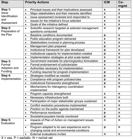
Table 3. The ICM Policy Process in Bagamoyo
Step Priority Actions ICM
Co-mgmt
• Principal issues and their implications assessed x x • Major stakeholders and their interests identified x x • Issue assessment reviewed and responded to x x • Issues for the initiative’s focus selected x x • Goals of the initiative defined x x Step 2:
Preparation of
• Scientific research targeted at selected management questions conducted
n p
the Plan • Baseline conditions documented p x • Public education program delivered x n • Stakeholders involved in planning process x x • Management plan prepared p x • Institutional framework for plan developed p x • Institutional capacity for implementation created p n • Implementation strategies at pilot scale tested x n Step 3:
Formal
• Government mandate for planning/policy formulation p n • Formal endorsement of policies/plan x n Adoption and
Funding
• Authorities necessary for implementation x n • Funding required for program implementation p n Step 4:
Implementation
• Strategies modified as needed p n • Compliance with program policies/rules p n • Institutional frameworks strengthened p n • Mechanisms for interagency coordination
implemented
x n
• Program capacity strengthened x n • Necessary infrastructure built n n • Participation of major stakeholder groups sustained x n • Conflict resolution procedures implemented x n • Position on the public agenda maintained x n • Performance monitored p n • Societal/ecosystem trends monitored p n Step 5:
Evaluation
• Impacts of Plan of Action on management issues assessed
n n
• Program adapted to its own experience and to changing social and environmental conditions
p n
Figure 3. Bagamoyo ICM Cycles
As shown in Table 3 above, the Bagamoyo district went through a thorough planning process when preparing the ICM action plan document. The district went through training, worked with villagers to identify and prioritize issues, formed an ICM working group, an ICM committee, a team leader, etc. A self assessment conducted in September 2001, found that the process had taken a bit longer than expected and that this was partly due to the fact that the capacity for ICM was very low in the district when they began. Nevertheless, the district approved the action plan in November 2001. The goal of the Bagamoyo action plan is to “improve the livelihoods of the local
communities along the coastal area through sustainable utilization of the coastal
resources in the district”. Following this goal, the plan has three objectives:
1. To reduce conflicts in the use of coastal resources
2. To ensure that destructive activities are controlled and resources improved 3. To build capacity in coastal management
The planning process identified nine issues, which were reduced to four through a
prioritization process: conflicts arising from shrimp trawling, illegal and uncontrolled cutting of mangroves, conflicts in the use of beaches, and destructive fishing practices. The plan laid out a number of actions that should be taken to address these issues and meet the
objectives.
After the plan was approved, there was a long gap until the implementation really took off in 2004. The delay was partially beyond the control of the district – because of lack of guidance and funding from the TCMP. But another reason might be that there was no real champion in the district that pushed for the implementation. During the two years that the action plan was relatively dormant, the district did a few activities that resulted in some second order
outcomes:
• Mangrove cutting and destructive fishing practices were reduced. This outcome was attributed to a greater awareness, created by the ICM action planning process.
• Mangroves and corals were replanted. These activities were done as collaboration between villagers, researchers, and district extension officers.
• Conflicts between trawlers and artisanal fishermen were reduced. Bringing the issue to the Department of Fisheries’ attention, the district succeeded in decreasing the number of trawlers in the Bagamoyo waters.
• Sustainable economic alternatives were tested. The program supported seaweed farming in coastal communities. The seaweed production was 14.8 tons in 2003, compared with 2.5 tons in 1998.
champion that it needed. So far, the implementation has included activities such as drafting a collaborative fisheries management plan, working with FINCA to deliver microcredit loans to coastal villagers for microenterprise development, conducting community based fisheries and coral reef monitoring, and conducting training for tour guides.
C
OLLABORATIVEF
ISHERIESM
ANAGEMENTThe process of developing the collaborative fisheries management (CFM) plan began in September 2004, with a study tour to the Tanga region for 18 villagers and district fisheries/forestry officers. Participants visited several villages covered by the Tanga Program, where they learned about the collaborative fisheries management efforts and the use of fishery no-take zones from the Tanga villagers. Several of these study tour
participants were involved in a workshop for “CFM champions”, along with members of Village Environmental Councils. They act as CFM leaders and work to spread awareness within the community. These champions were key in the village awareness meetings that were held in December 2004-January 2005. Over 800 persons, representing elders, women, and fishermen participated in 22 meetings held during this period.
Through the community participation process, fisheries issues and concerns were identified. At the same meetings, the fishermen and village governments selected possible CFM no-take zones in the district. In March 2005, District Fisheries Officers followed up with informal talks with Dunda fishers. This is an especially large group of fishers, which showed
disinterest in hearing about the CFM concept in a formal meeting environment. After individual discussions with the Dunda fishers, they became more positive about the CFM plan and saw that it could be a means to deal with their concerns.
A team of scientists and village fishermen performed a rapid ecological assessment of the proposed coral reef no-take areas to determine which were most suitable for no-take zones. District fisheries officers and private stakeholders (hotel owners) also participated and provided resources to support this effort. The team recorded the coral composition and health, status of commercially important fish species, and status of invertebrates. They also mapped the locations of all suggested reefs. The ecological assessment results (Table 4) and recommendations were discussed in meetings with village governments and fishers.
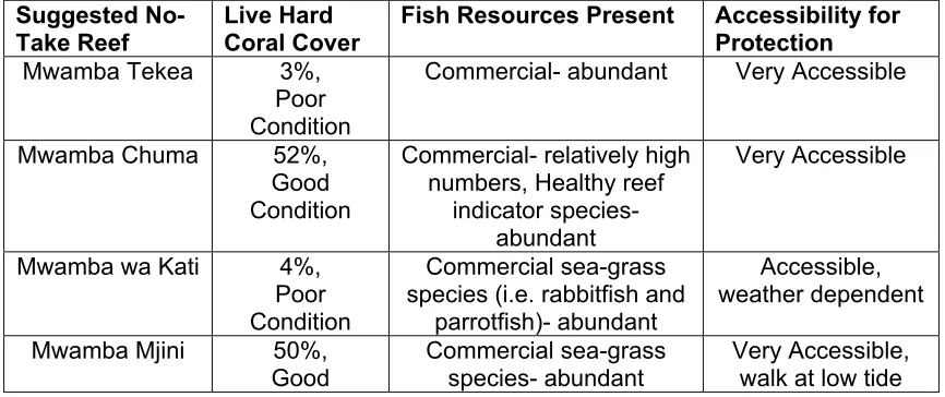
Table 4. Results of the Ecological Assessment of Suggested CFM No-Take Areas
Suggested No-Take Reef
Live Hard Coral Cover
Fish Resources Present Accessibility for Protection
Mwamba Tekea 3%, Poor Condition
Commercial- abundant Very Accessible
Mwamba Chuma 52%, species (i.e. rabbitfish and
Condition
Panda Mbili Seagrass Beds Only
After the ecological assessment meetings, village governments, along with fishers, made their final selection of CFM no-take areas (Table 5).
Table 5. Selected No-Take Areas and Responsible Villages
SELECTED NO-TAKE AREAS VILLAGES WITH MANAGEMENT AND ENFORCEMENT RESPONSIBILITY
Maduga Mapinga, Kondo
Mshingwi Mlingotini, Pande
Mjini Magomeni, Dunda, Kaole
Poyogo Magomeni, Dunda, Kaole
Following the identification of management issues and the selection of no-take areas, each village government selected ten representatives, which included fishermen, to participate in a workshop to establish management structures and bylaws for the management area. During the CFM Management Workshop the participants agreed on the following:
• The overall management goal, the objectives of the Fisheries Management Plan, solutions to address major fisheries issues, and expected results.
rules for the CFM larger area, and other actions to support the management objectives (i.e. actions to control small mesh seine nets and trawlers).
• Defined how bylaws and rules will be enforced, who will do what, and what the penalties will be. The also set up patrol efforts by the village Defence and Security Committee (Kamati Ulinzi na Usalama) to enforce fisheries bylaws and regulations.
• Outlined a program for monitoring and evaluation, including who will do what and the training required.
• Planned meetings with villagers and village governments to present the Management Plan (especially the reef closures), bylaws, and expected results.
The CFM was finalized in June, 2005 and is currently awaiting approval by the district
government. The CFM covers seven villages and their fishing zones (Figure 2) and its goal is
“to rebuild fish stocks and associated habitats to levels that allow for increased and sustainable fish catches by artisanal fishers, and that results in improved income for
artisanal fishers in the Bagamoyo District”. The CMF identifies a number of actions to
address its three key issues:
Issue 1. Depletion of fish stocks due to over-fishing and harvesting of juveniles
• Establish no-take areas (closed to all industrial and artisanal fishing, collection, and other extractive uses for one year)
• Increase enforcement efforts to ensure that only licensed fishers are allowed to fish in the area and that they are using only legal gears.
• Promote other income-generating activities such as seaweed farming and beekeeping promoted in villages
• Implement a net exchange program to prevent use of small mesh sized nets and beach seine (also See Habitat Destruction Issue Below)
• Encourage trawlers to adopt bycatch reduction devices. (See Trawler Issue Below)
Issu
e 2. Habitat destruction due to unsustainable fishing (and other) practices• Implement a net exchange program to prevent use of small mesh sized nets and beach seines
• Implement awareness campaigns to teach stakeholders responsible natural resource practices
• Restrict industrial trawling areas (See Trawler Issue Below)
• Increase and target enforcement efforts against destructive, illegal fishing methods (also See Depletion of Fish Stocks Issue Above)
Issue 3. Conflict between trawlers and artisanal fishers
• Establish no-take trawling areas for near shore areas of along Bagamoyo district (See Depletion of Fish Stocks Issue Above)
•
Provide forums for Community and artisanal fisher concerns to be heard by central government authoritiesT
HEC
OASTALM
ANAGEMENTP
ORTFOLIOThe coastal management activities in Bagamoyo are like a Russian doll, where you’ll find many layers of ICM planning and implementation that fits nicely within each other. The outer-most layer is the National ICM Strategy. The Strategy stresses the need “to preserve, protect and develop the resources of Tanzania’s coast for use by the people of today and for succeeding generations to ensure food security and to support economic growth.” One of the principles of the Strategy is that coastal development decisions need to be consistent with the government’s priority of poverty alleviation and food security. This principle is
acknowledged across the portfolio of ICM initiatives in Bagamoyo, as all the implementation efforts include microenterprise and/or livelihood improvement initiatives as components of coastal management and biodiversity conservation.
The second layer of ICM in Bagamoyo is the District Action Plan. The district is
implementing the district action plan through sustainable aquaculture development (seaweed and milkfish). In its first year and a half, SUCCESS has worked with close to one hundred women and men to establish their own farms and market independently to seaweed buyers – thereby breaking the dependence on buyers for capital inputs for farming. In the Mlingotini village, the Program is working with a group on a pilot floating farm as an alternative to the off-bottom peg-and-line method that is plagued with problems of die-off and disease. Seaweed farming trails with E. cottonii, which is more environmentally sensitive, have also shown that the floating method in Mlingotini is producing 1.2-2.9 times higher production than the bottom method and are not experiencing the seasonal die-offs associated with the off-bottom method.
Earlier on, it was noted that as the seaweed grows on the floating farm, it becomes a fish aggregation device prompting fishermen to fish around the farm. Twice, this has resulted in damage to the floating farm. As a response, the seaweed farmers have acquired a boat and standby light to help them guard and visit the area at night. They have also been provided with 10 local fish traps so that they can harvest fish as an added-value to seaweed farming. To address the issue of fishermen destroying the floating farms, the SUCCESS team has also initiated a community based planning and conflict resolution scheme to help the seaweed growers and fishers agree on how to zone the area.
Finally, the Population, Equity, AIDS, and Coastal Ecosystems (PEACE) Project, works in Bagamoyo and Pangani to promote improved biodiversity conservation through the sustainable use of coastal resources while at the same time seeking to enhance the quality of life of coastal people in Tanzania. PEACE is currently implementing pilot mitigation
measures to address the impacts of HIV/AIDS on Coastal Biodiversity. This includes helping women and other vulnerable groups start alternative livelihoods such as paprika farming and milkfish culture— livelihoods that do not further stress the coastal resources or threaten coastal biodiversity. Other mitigation measures include introducing the use of fuel-efficient stoves and establishing wood lots instead of cutting mangroves and/or coastal forests for fuel-wood. The Project has also been undertaking communications campaigns targeted at the community-level and including the use of theatre to get across messages on the relationship between HIV/AIDS and natural resource use.
F
IRSTO
RDERO
UTCOMEA
SSESSMENTThe Orders of Coastal Governance Outcomes Framework (Olsen 2003) groups outcomes of coastal management along a trajectory that traces the advance to more sustainable forms of coastal development. The framework emphasizes that the first threshold is creating the enabling conditions that make integrated forms of coastal management feasible. These “First Order Outcomes” are: constituencies that actively support an ICM initiative, a formal
governmental mandate for the program along with the authority necessary to implement a course of action, resources (including sustained funding) clear unambiguous goals, and institutional capacity. The second threshold is to gauge the success of implementing an ICM program in terms of the changes in behavior that are required to meet its goals. Only after the requisite changes in behavior (Second Order Outcomes) have been practiced for a sufficient period can improvements be expected in the environment and in the social benefits (Third Order Outcomes) that may be attributable to a coastal management program.
shows that district has succeeded in building constituency for ICM in the coastal villages, which have been involved in developing the district action plan as well as the CFM. Villagers are also involved in implementation, through community based monitoring, patrolling, and livelihood schemes. There is a general feeling that the villagers are interested and excited about the ICM activities. There is also good support for the ICM process at national and district levels.
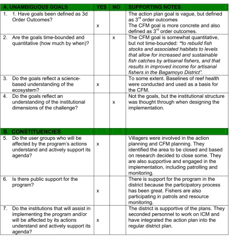
Table 6. First Order Outcome Assessment
A. UNAMBIGUOUS GOALS YES NO SUPPORTING NOTES
1. 1. Have goals been defined as 3d Order Outcomes?
x
The action plan goal is vague, but defined as 3rd order outcomes
The CFM goal is more concrete and also defined as 3rd order outcomes.
2. Are the goals time-bounded and quantitative (how much by when)?
x The CFM goal is somewhat quantitative, but not time-bounded: “to rebuild fish stocks and associated habitats to levels that allow for increased and sustainable fish catches by artisanal fishers, and that results in improved income for artisanal fishers in the Bagamoyo District”.
3. Do the goals reflect a science-based understanding of the ecosystem?
x
To some extent. Baselines of reef health were conducted and used as a basis for the CFM.
4. Do the goals reflect an
understanding of the institutional dimensions of the challenge?
x
Not the goals, but the institutional structure was thought through when designing the implementation.
B. CONSTITUENCIES
5. Do the user groups who will be affected by the program’s actions understand and actively support its agenda?
x
Villagers were involved in the action planning and CFM planning. They
identified the area to be closed and based on research decided to close some. They are also supportive and engaged in the implementation, including patrolling and monitoring.
6. Is there public support for the program?
x
There is support for the program in the district because the participatory process has been great. Fishers are also
participating in patrols and resource monitoring.
7. Do the institutions that will assist in implementing the program and/or will be affected by its actions understand and actively support its agenda?
x
8. Has the program successfully negotiated its place within the roles and responsibilities of pre-existing institutions?
x
The implementation utilises the existing village and district institutional set up. Only one new committee has been formed – the central coordination committee (see appendix B)
C. COMMITTMENT
9. Is there a clear, unambiguous and long-term commitment of authority from government that gives the program the powers it needs to implement its program?
x Since there has been no changes to the institutional set up of implementing the action plans and CFM each level understand clearly its role and responsibilities.
10. Have sufficient financial resources been committed to fully implement the program?
x
The plans are dependent on external funding from TCMP. The District provides a small match in form of office space etc.
11. Have the program’s policies and a plan of action been formally approved by the appropriate level of government?
District action plan was formally approved in 2001. The fisheries management plan is still awaiting approval.
12. Does the program’s mandate and authority extend over more than one sector?
x
Yes both plans are integrated spanning over many sectors. To achieve integration, the district formed an ICM committee, comprising of the heads of relevant sectors, and an ICM working group comprising of representatives from district sectors, private interests, and NGOs. D. CAPACITY TO IMPLEMENT
13. Does the program possess the human resources to implement its plan of action?
x
The district and villagers have good knowledge about ICM, but they still lack technical know-how
14. Do those human resources have the sufficient, relevant capacity to implement all elements of the program?
x
Partially – they lack capacity to continue the monitoring program without assistance from TCMP.
15. Have the lead institutions responsible for program
implementation demonstrated the ability to practice adaptive management?
x
Not yet.
16. Is there voluntary compliance with program rules?
x To some extent. Some of the dynamite fishers are part of the monitoring team. 17. Is emerging scientific knowledge
being incorporated into the program’s policies and plans?
x Yes, the monitoring program is feeding into the planning process.
without doubt the lack of capacity. The district has come a long way since the ICM process started and most people are comfortable with the ICM planning cycle, but they still lack the necessary technical and extension capacity.
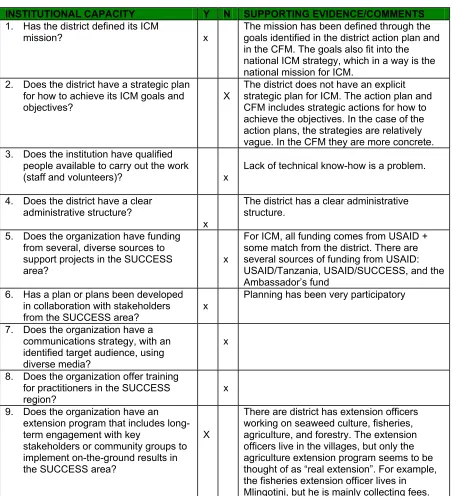
M
ANAGEMENTC
APACITYConducting the governance baseline, we spent some time discussing the management capacity of the Bagamoyo district and, as stated above, this is seen as a big gap among the district staff. The table below highlights some of the issues that came out in our discussions.
Table 7. Management Capacity
INSTITUTIONAL CAPACITY Y N SUPPORTING EVIDENCE/COMMENTS
1. Has the district defined its ICM
mission? x
The mission has been defined through the goals identified in the district action plan and in the CFM. The goals also fit into the national ICM strategy, which in a way is the national mission for ICM.
2. Does the district have a strategic plan for how to achieve its ICM goals and objectives?
X
The district does not have an explicit strategic plan for ICM. The action plan and CFM includes strategic actions for how to achieve the objectives. In the case of the action plans, the strategies are relatively vague. In the CFM they are more concrete. 3. Does the institution have qualified
people available to carry out the work
(staff and volunteers)? x
Lack of technical know-how is a problem.
4. Does the district have a clear administrative structure?
x
The district has a clear administrative structure.
5. Does the organization have funding from several, diverse sources to support projects in the SUCCESS area?
x
For ICM, all funding comes from USAID + some match from the district. There are several sources of funding from USAID: USAID/Tanzania, USAID/SUCCESS, and the Ambassador’s fund
6. Has a plan or plans been developed in collaboration with stakeholders from the SUCCESS area?
x
Planning has been very participatory
7. Does the organization have a communications strategy, with an identified target audience, using diverse media?
x
8. Does the organization offer training for practitioners in the SUCCESS region?
x
9. Does the organization have an extension program that includes long-term engagement with key
stakeholders or community groups to implement on-the-ground results in the SUCCESS area?
X
10. Has the organization produced and disseminated studies of lessons learned and best practices, from the SUCCESS area, that are
interdisciplinary and of high quality?
x
Only TCMP documents
11. Does the organization have formal and informal structures for facilitating learning within the organization and the SUCCESS area?
x
There has been one self assessment, but it was done through TCMP. It was not the district’s initiative.
EXTENSION CAPACITY Y N SUPPORTING EVIDENCE/COMMENTS
1. Is there in-country extension capability on key ICM topics?
x
Yes, but see question 9 above
2. Are services and supplies that producers, or others receiving extension support, need readily available?
x
Yes, to some extent. There are mariculture supplies and the district just received a boat for patrolling. But fuel is always an issue.
3. Are roads, transport and storage
facilities adequate? x
Storage is not adequate, especially for fish, but also for seaweed. The roads are ok to some villages, but not to others (e.g. Buyuni). 4. Does extension supply adequate
educational support materials for field
workers? x
There is little extension materials and existing materials are not distributed to the villages. It stays in the district headquarters. 5. Do field workers provide regular
in-service training? x
The only example of extension training in the district is within agriculture. There is
extension training on seaweed culture too, but that is done by IMS, through the SUCCESS program or by seaweed buying companies.
6. Is the linkage of extension with research agencies working?
x
Not really, except through the work that the SUCCESS program is doing around seaweed.
7. Have the experience of those receiving the extension support been adequately captured in lessons learned?
x
8. Does government provide or allow incentives that favor natural resource-based coastal livelihood
development?
x All support is provided by projects
In Tanzania, groups and associations, based within the village government (e.g.
up, the lack of capacity seems to have three layers: lack of technical know-how, lack of extension culture, and lack of funding to implement a full-fledged extension program.
Bibliography
Bagamoyo District Council and Tanzania Coastal Management Partnership (2001).
Integrated Coastal Management Action Plan. Bagamoyo, Bagamoyo District Council:
20.
Madulu, N. F. (2005). Environment, poverty and health linkages in the Wami River basin: A search for sustainable water resource management. Physics and Chemistry of the Earth
30(11-16): 950-960.
Melamari, L., N. F. Madulu, et al. (2003). Baseline Study in the Wami-Mbiki Pilot WMA in Morogoro, Mvomero, and Bagamoyo Districts. Dar es Salaam, Ministry of Natural Resources and Tourism, Wildlife Division.
Semesi, A. K., Y. Mgaya, et al. (1999). Coastal Resources of Bagamoyo District, Tanzania.
Marine Science Development in Tanzania and Eastern Africa: Proceedings of the 20th Anniversary Conference on Advances in Marine Science in Tanzania. M. Richmond and J. Francis. Zanzibar, Tanzania, WIOMSA: 517-533.
Tanzania Coastal Management Partnership (2003). Tanzania State of the Coast 2003: The National ICM Strategy and Prospects for Poverty Reduction. Dar es Salaam, TCMP. Tanzania Coastal Management Partnership and Bagamoyo District (2003). Draft Community
Based Fisheries Management Plan. Bagamoyo, Bagamoyo District Council: 28. Tanzania National Bureau of Statistics (2002). Household Budget Survey 2000/01. Dar es
Salaam, National Bureau of Statistics, Government of Tanzania.
Torell, E. (2001). Reflection on the first year of district action planning. Dar es Salaam, Tanzania Coastal Management Partnership.
Torell, E. (2002). "From Past to Present: The Historical Context of Environmental and Coastal Management in Tanzania." Development Southern Africa 19(1).
Appendix A. Summary Timeline of Pressure, State, and Response in Bagamoyo
YEAR PRESSURE
CHANGES IN STATE
RESPONSE AND traders. It was a large slave trade port
1868
• First church was built in Bagamoyo by
missionaries mid
1880s
• Tanganyika became a German colony
1898
• German administration established an
ordinance for mangroves
1919
• Tanganyika became a British colony
1920s
• The British expand mangrove reserves to cover 80,000 hectares on the mainland
1950s
• Wild harvest of native seaweed begins
• The harvest of seaweed in the range of 400-800 tons per year
1970s
• Trawling begins • Dynamite fishing begins
(as a consequence some says)
• Shrimp fishers catch about 100 kilos of shrimp per day
• Stocks of prawns, fish, crabs, seacucumbers, to collapse by 1976
mid. 1980s
• Dynamite fishing is out of control with blasts occurring two times per day in Bagamoyo.
• The average daily catch per licensed fisherman is 75 kilos.
1987
• Director of forestry imposed a national ban on the cutting of mangroves
1988
• Number of licensed fishermen is 780 • There are 12 trawling
1990 • 436 persons are beach seining
1993 • First hotel built in Bagamoyo
1994
• Mangrove management plan was approved, calling for protecting and zoning all mangroves in Tanzania.
1996 • Number of traditional fishing vessels is 120.
1997
• National fisheries policy adopted
• National environmental policy adopted
1998
• Seaweed farming begins in Bagamoyo
2000 • District Action Planning process begins
2001 • District Action Plan is approved
2002 • The road from Dar es Salaam is completed
• National ICM strategy is approved
2003
• Seaweed die off • Shrimp fishers catch
5-10 kilos of shrimp per day. They have to go to deeper water to get their catch.
• Agreement between Bagamoyo district and dept. of fisheries to limit shrimp trawling during peak artisanal fishing season.
• Ecological Monitoring Program begins, led by TCMP
2004
• Number of licensed fishermen is 1918. • Number of traditional
fishing vessels is 368 • 523 persons are beach
seining.
• Mangrove clearing increases
• The total daily catch per licensed fishermen (25 • Bagamoyo is declared a
world heritage site • SUCCESS Program
starts working on alt ways to grow seaweed.
2005
• Bagamoyo now has 8 tourist hotels
• There are 25 trawlers in the country
• Saadani becomes a National Park
• Collaborative Fisheries Management Plan developed
Appendix B. Roles and Responsibilities in the CFM
The roles and responsibilities of various stakeholders involved in the CFA are described below. Only one new institution will be established: the Central Coordinating Committee (CCC). This is a joint committee of representatives from each village and the hotel
association. It is established based on a similar committee used in the Tanga Coastal Zone model. All resource users in the stakeholder villages should participate in all management activities of the CFM area.
1. Village
a) Formulate village by-laws
b) Two fishers and one representative from the Village Environmental Committee (VEC) will be selected from each village to form the Central Coordinating Committee, with at least one woman from each village.
c) The Security Committee from each village is responsible for by-law enforcement through patrol efforts.
d) VEC and Security Committee hold committee meetings twice a month. e) The VEC prepares annual and quarterly work plans of fisheries issues and
presents them to the Village Government and CCC.
f) VEC prepares and presents monthly progress reports to the Village Government and CCC secretary.
g) Report fisheries activities to the Ward Executive quarterly Dunda Ward- Dunda and Kaole
Zinga Ward- Pande, Mlingotini, Kondo, Mapinga Magomeni Ward- Magomeni
h) Villagers should report on all crimes occurring in the village to the Village Government
i) Villagers should attend all meetings in the villages as per Village Government announcement
2. Central Coordinating Committee (CCC)
a) CCC is made up of two fishers and one member of the VEC from each village (at least one woman from each village), two representatives from the
Bagamoyo Hotelier’s Association, and two representatives from the District Natural Resource Office (including Fisheries) (ICM Committee?)
b) Resolve conflict and oversee decision-making within management area c) Visit neighboring villages to discuss various issues and give feedback d) Receive and review quarterly work plans from respective villages e) Seek technical and judiciary advise for the management area f) Present monthly progress reports to the District Council
3. District Fisheries Officers
a) Provide guidance and oversight to the CCC b) Ensure law enforcement
c) Provide a link between the CCC and District Council d) Ensure proper use of materials provided to villages
e) Provide technical advice, personnel, and training to villages per request
a) Approve and review the management plan and village by-laws from the CCC b) Budget for implementation actions
c) Provide materials and resources that are outside village capacities d) Forward management plans to Central Government
e) Receive monthly reports from the CCC and feedback issues for action/comments
f) Provide judicial advice
5. Central Government (Department of Fisheries) a) Review and endorse management plans
b) Formulate, review, and support enforcement of laws
c) Direct outside activities (e.g. Prawn Trawl Industry) to correspond with management area plans and regulations
d) Assist with development of Community Fisheries Plan
6. Private Sector (Mainly Tourism and Hotel Operators) a) Hotels provide bimonthly patrolling of no-take areas
b) Two representatives from the Hotelier’s Association are selected to join the CCC.
c) Provide a venue for CCC meetings and transport when needed