Ha za rd, C a pa c ity & Vulne ra b ility Asse ssm e nt in re la tio n to
C lim a te C ha ng e
Pre pa re d b y
C ha lle ng e to C ha ng e , The Dra g o n Insitute , The Me ko ng Ric e Institute , C a n Tho Unive rsity
with suppo rt fro m Hue Unive rsity, Hue Unive rsity o f Ag ric ulture & Fo re stry, C a n Tho Pe o ple ’s C o m m itte e , DO a nd o the r De pa rtm e nts o f C a n Tho C ity, Re d C ro ss, lo c a l c o m m uni
NRE
tie s
HCVA
in
Can
Tho
Contents
1. INTRODUCTION
1.1 Introduction of ACCCRN 4
1.2 Can Tho City 4
2. METHODOLOGIES
2.1 Objectives of HCVA 8
2.2 Process of HCVA 9
2.3 Steps 9
2.4 Tools and Methods 10
2.5 Human resources and participating organisations 11 3. DISASTERS MANAGEMENT
3.1 Structure 11
3.2 Disasters Mangement in Binh Thuy District 12 3.3 Disasters Management in Vinh Thanh District 15 4. INTEGRATION INTO SOCIO-ECONOMIC DEVELOPMENT PLANS
4.1 Socio-economic development planning 16
4.2 Key issues of integration 17
5. GENDER AND CLIMATE CHANGE
5.1 Women’s groups of flood kindergartens 19
5.2 Women’s groups of taking children to school across rivers 21
5.3 Access to loans of poor men and women 22
5.4 Migrants including poor women with children 24
5.5 Women-headed households 25
6. HCVA FOR BINH THUY DISTRICT
6.1 Hazards and Impacts 25
6.2 Disasters Management 33
6.3 Education 36
6.4 Health 40
6.5 Water supply and environment 43
6.6 Livelihoods 46
6.7 Housing 56
6.8 Most vulnerable groups 56
7. HCVA FOR VINH THANH DISTRICT
7.1 Hazards and Impact 60
7.2 Disasters Management 68
7.3 Education 69
7.4 Health 72
7.5 Water supply and environment 78
7.6 Livelihoods 83
7.7 Housing 99
7.8 Most vulnerable groups 100
8. RECOMMENDATIONS
8.1 Integration 104
8.2 Adaptation in Binh Thuy 105
8.3 Adaptation in Vinh Thah 111
Abbreviations
A-B-C-D-E-F-G-H-I-J-K-L-M-N-O-P-Q-R-S-T-U-V-W-X-Y-Z
ACCCRN The Asian Cities Climate Change Resilience Network
Mạng lưới Chống chịu với Biến đổi Khí hậu c a các Thành phố Châu Á CBDRM Community-based Disaster Risk Management
Quản lý R i ro Thảm họa dựa vào Cộng đồng
CC Climate Change
Biến đổi Khí hậu (BĐKH) CCA Climate Change Adaptation
Thích ứng Biến đổi Khí hậu
CFSC Committee for Flood and Storm Control Ban Chỉđạo Phòng chống L t bão CtC Challenge to Change
Thử thách Thay đổi CT Can Tho City
Thành phố Cần Thơ (TPCT)
CTAPCC City Target Action Plan for Climate Change
Kế hoạch Hành động M c tiêu Thành phố về Biến đổi Khí hậu CTU Can Tho University
Đại học Cần Thơ (ĐHCT)
DM Disaster Management
Quản lý Thiên tai
GDP Gross Domestic Product Tổng Sản phẩm Nội địa
HCVA Hazard, Capacity and Vulnerability Assessment
Đánh giá Thiên tai, Khả năng Thích ứng và Tình trạng dễ bị tổn thương ISET Institute for Social and Environmental Transition
Viện Chuyển giao Xã hội và Môi trường MD Mekong River Delta
Đồng bằng Sông Cửu Long (ĐBSCL) MPI Ministry of Planning and Investment
Bộ Kế hoạch và Đầu tư
PC People’s Committee
y ban Nhân dân (UBND)
RF Rockefeller Foundation
Quỹ Rockefeller
SEDP Socio-economic Development Plans Kế hoạch Phát triển Kinh tế - Xã hội SPDM Strategic Plan for Disaster Management
Kế hoạch Chiến lược về Quản lý Thảm họa
SC Steering Committee
Ban Chỉđạo
VND Vietnamese Dong
1. INTRODUCTION
1.1 SUMMARY OF ACCCRN
The Asian Cities Climate Change Resilience Network (ACCCRN) in India, Vietnam, Indonesia, Thailand, was intiated and supported by the Rockefeller Foundation in 2009. It aims to create robust models and methodologies for assessing and addressing climate risk in Asian cities, especially building resilience among poor and vulnerable communities. By 2012 cities in the network will develop robust plans to prepare, withstand and recover from the predicted impacts of climate change.
The ACCCRN Program in Vietnam is supported by the Institute for Social & Enviornmental Transition (ISET), and Challenge to Change (CtC), and the National Institute for Strategy and Policy Studies (NISTPASS). One of the first steps of ACCCRN in Vietnam is the Hazard, Capacity and Vulnerability Assessment in the three cities. This is a participatory process engaging all levels of the city, focusing on the needs of highly vulnerable communities. The activity is coordinated and facilitated by CtC in collaboration with key City partner institutions.
1.2 CAN THO CITY AND DISTRICT PROFILES
Can Tho City is a biggest city in the Mekong River Delta (MD), once known as Tay Do (Western Capital). Its natural area is 1,401 km2 (Statistical Office of Can Tho City, 2007). Located beside the western bank of the Hau River (10° 2Ɵ 0Ơ N, 105° 47Ɵ 0Ơ E), Can Tho borders An Giang and Dong Thap provinces in the north, Hau Giang province in the south, Kien Giang province in the west, Vinh Long and Dong Thap provinces in the east (Figure 1). By the water way, Can Tho City is 75 km far away from East Sea. By the national road, it is 1,877 km from Ha Noi Capital in the north and 169 km from Ho Chi Minh City in the west-south direction. Can Tho is connected to the rest region of the country by National Road 1A, Cai Cui Port and Can Tho Airport. The Can Tho Bridge crossing the Mau River is under construction. The city has a dense system of rivers and canals serving for agriculture, aquaculture, navigation and water supply for the region.
Figure 1. Location and administrative map of Can Tho City
After 120 years of development, Can Tho City is considered as a political, cultural, scientific and economical centre of the region. Can Tho is one of five cities under the Central Government since January 2004. Administratively, Can Tho has four urban districts (i.e. Ninh Kieu, Binh Thuy, O Mon, and Cai Rang) and four rural districts (Phong Dien, Co Do, Thot Not, and Vinh Thanh). Can Tho has 1,159,008 people (Statistical Office of Can Tho City, 2007), in which 65% among them living in rural and suburban areas. The average population density for the whole Can Tho City in 2007 was 827 person/km2, in which the highest density was in Ninh Kieu district (7,392 person/km2)and the lowest density was in Vinh Thanh District (376 person/km2). The amount of population at labour age in 2007 was 735,158 persons (occupying 63.42% of the total population). As statistical data in 2007, about 35.63% of labour forces in Can Tho City were working in agriculture, forestry and fishery sectors and the remainder were in non-agricultural sectors (Table 1).
Table 1: Population and labour distribution in Can Tho City
Population Labour Distribution
Total Male Female Total Male Female Can Tho City 1.159.008 571.166 587.842 735.158 367.841 367.317 Ninh Kieu District 214.379 104.102 110.277 147.527 73.291 74.236 Vinh Thanh District 154.225 75.974 78.278 92.426 46.248 46.178 Source: Statistical Office of Can Tho City, 2007
If compared the GDP growth in three periods, 4.99% in 1976 – 1985, 9.42% in 1986 – 2000 and 13.5 % in 2001 – 2005, the development of Can Tho was promising. In 2007, its economic structure included 15.15% of agriculture, forestry and fishery; 41.23% of industry and construction and 43.62% of commerce and service. In present, Can Tho’s economic structure is reforming towards industrialization and urbanization. The changes of economic sectors are leading many challenges to social structures and poverty.
Hazard Ranking Most Vulnerable Districts Ranking Flood 1 Vinh Thanh (rural district) 1
Tide 2 Co Do (rural district) 1
Storm 3 Binh Thuy (urban district) 2
Drought 4 Phong Dien 3
Thot Not 3
Cai Rang 3
One highly vulnerable urban district and one highly vulnerable rural district were selected for carrying out this hazard, capacity and vulnerability assessment: Binh Thuy (urban) and Vinh Thanh (rural).
Bình Thủy District
Binh Thuy District, a suburban district in Can Tho City, covers an area of 69 km². In 2007, the district had the population of 94.871 with the average population density of 1,336 persons/km2. Binh Thuy is divided into 8 wards such as Tra Noc, Tra An, An Thoi, Bui Huu Nghia, Thoi An Dong, Binh Thuy, Long Tuyen and Long Hoa.
Bui Huu Nghia ward which was chosen for survey implementation in Binh Thuy District (Figure 2) covers an area of 637,12 ha. Statistically (in 2008), there were 11,102 local habitants with 2,180 households and 782 temporary inhabitants with 201 households. The household survey was implemented in Section 3 and Con Son in Bui Huu Nghia.
• Section 3 is located on Cach mang Thang 8 Street on the way from Ninh Kieu district to Binh Thuy Bridge. The majority of households in this area are poor and average, and they are landless; their living mainly relies on manual labour and small business. • Con Son, which is a small islet, is located on the right bank of Hau River, nearby Binh
Thuy ward. Con Son which belongs to Section 1 in Bui Huu Nghia ward has approximately 90 households. Typically, most of local people are poor farmers who have farming land, and infrastructure is deficient, which is difficult and limited since local people have to commute by boat.
Vinh Th nh District
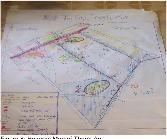
Vinh Thanh which is a rural district is located in the northwest of Can Tho City (Figure 3). Vinh Thanh District was established in May 2004 based on Decree No. 05/2004/ND-CP, with an area of 410 km². According to the population report in 2007, the district had the population of 154,225 with average population density of 376 persons/km2, and it is categorized as the district which has the lowest population in Cantho city. District People’s Committee is located Thanh An town. The district consists of two towns such as Thanh An and Vinh Thanh, 9 villages including Vinh Trinh, Vinh Binh, Thanh My, Thanh Quoi, Thanh An, Thanh Tien, Thanh Thang, Thanh Loi and Thanh Loc.
Thanh An town has a natural area of 11,768.3 ha. The town has four hamlets with 2,515 households (14,271people). The town has 3 main canals with the road system that is: Thầy Ký canal with asphalt road on one side and concrete road on the other side. Cai San along National highway No 80 and canal 16 with road system. Small canals such as D has the concrete road of 3 meters wide. Canal E has had a road system planned leading to the Food and Foodstuff processing zone which will be built on an area of 49.2 ha. Main characteristics are the local people are living two sides of the canals. Where the roads along the rivers/canals are earthen made, fewer people are residing. Total number of temporary houses of the town is 503 (with 3,013 people). In the centre of the town, there is one building for the People’s Committee, secondary school, one semi boarding school, 1 primary school and 1 high school. There is one Health station near the school. Main market is located on National Highway no 80 and there is one flood resettlement cluster for 262 households, which was built in 2002.
Figure 3: Vinh Thanh District and surveyed areas
since they have to cope with environmental pollution, lack of garbage collection system; especially clean water as well as agricultural sanitation are still poor in Bo Bao.
Bờ Bao is located in the southwest of Thanh An town with Bo Bao River alongside the hamlet of 8km. There are 9 units in the hamlet with 326 households, including 28 poor and 28 near poor households (government criteria). The whole hamlet has 90 temporary leafy houses from the most difficult households. Most of these households made their houses on the side of the river as they do not have land ownership. Around 120 houses have toilets. Only around 28% of the households have clean water as there is one clean water supply station for 87 households. Rice cultivation is the main livelihoods in Bo Bao hamlet.
Ph ng Quới A hamlet is located in the centre of Thanh An Town. The hamlet has the natural area of 550 ha, of which 530 ha is for rice cultivation. Main livelihoods activities of the local people in the hamlet are agriculture and trading (market area: trading, services such as fertilizer agencies, vet agencies, 3 pharmacies. All the poor households who often do not have cultivation area have to work as hired labour. The hamlet has 24 units with its head, vice head and secretary. The units are divided based on production arrangement. The hamlet has one flood resettlement cluster, 3 schools near the People’s Committee office. The town health centre and the main market are located in the hamlet too. In the hamlet there is one church and one pagoda as rescue areas for the families during big floods. Most of the local people reside mainly along CAi San river alongside the town and others such as D, C, E, 16, 18 Thay Ky and 15.5 (Sau Hau).
2. METHODOLOGIES
2.1 OBJECTIVES
As a part of project objectives, CtC applies a participatory approach to conduct Hazard, Capacity and Vulnerability Assessment (HCVA) to:
• Identify the most vulnerable communities and most vulnerable households/groups within targeted communities in Binh Thuy (urban district) and Binh Thanh (rural district) of Can Tho City.
• Provide sufficient samples from which pilot projects according to programme criteria, can emerge;
• Contribute to the identification of necessary city research issues for the program of Institute of Social and Environment Transition (ISET) and for the preparation of Phase 3 investment.
• Form information base to facilitate Community-based Disaster Risk Management (CBDRM) and Climate Change Adaptation (CCA) and resilience planning in the selected area, which can be integrated within Socio-economic Development Plans (SEDPs).
International experiences have shown that one important feature of good planning is integration. A plan which has been done in isolation tends to serve limited purposes with narrow interests and a small number of people. On the contrary, an integrated planning is likely to yield more impacts, minimize risks and avoid unnecessary waste and losses.
• Review the socio-economic planning, urban planning processes from the city to ward levels. This includes identifying the timing, contents and local capacity for conducting the planning.
• Assess to which extent the disaster management and climate change responsive aspects have been integrated in the current planning processes.
• Identify any constraints on the planning process, issues in implementation of the current planning with regard to incorporating disaster management and climate change responses into the mainstream planning processes.
• Make recommendations as to how disaster management and climate change related aspects can be integrated in the future planning processes.
2.2 PROCESS
A. Levels
1. HCVA from city to village level. 2. Results of assessment were
feedbacked from village to commune/ward to city level.
B. Key contents of assessment
1. Hazards assessment to determine potential and secondary hazards 2. Assess the vulnerability by disasters
and climate change and identifying the impacted areas/themes; identifying most vulnerable groups. 3. Assess the impacts of disasters and
climate change on gender 4. Identify the key areas impacted.
2.3 STEPS
Preparation:
- Development of conceptual framework: based on international and local sourced literature views, practical experiences of CtC Staffs and review discussion with other NGOs staff of Climate Change working group (Care, Oxfam, Netherlands Red Cross), Gender, Governance, Disaster Management specialists, staff from Can Tho University (Dragon Institute and Mekong Research Institute), staff from Hue Agriculture-Forestry university and staff from Hue University. One day team work was spent on briefing of the scenarios of CC on Mekong Delta, and Can Tho, and sharing the key tools and purposes for different groups such as livelihoods, environment, health, education, Disaster Management, gender and governance.
- Developing specific assessment plan of HCVA with the key partner of the city, DONRE to organize the field work.
- Local facilitators were key assistants of assessment team/project from city Gov agency and mass organization of ward/commune. Local facilitators come from the City Red-Cross, DONRE, staff of people’s committee offices, women’s union, farmers’ union, health, education departments at district and commune/ward level, and land survey officer at town and ward centres.
HCVA
District/commune/ward HCVA
At city level
HCVA Hamlet/village
- Briefing of climate change scenarios for the city with supporting document provided by ISET and Can Tho Dragon Institute.
- Orientation session of HCVA process, methodology, expected results and specific plan for representatives’ city divisions, and people committee and mass organization of ward/commune.
- Lessons learned from HCVA are consolidated after the HCVA has been completed. Conducting HCVA:
- At city level (1 day): hazard assessment to identify potential hazards, most vulnerable ward/communes, most affected sectors and issues/concerns/needs assessment responding to climate change, coping experiences and good practices for disaster mitigation of the city
- At ward/commune level (2.5 days): hazard assessment to identify main hazards/secondary hazards, most vulnerable ward/communes, most affected main economic activities and problems analysis responding to climate change, coping experiences and good practices for disaster mitigation of the ward/commune, priority of adaptation options.
- At section/village level (2 days): hazard assessment to identify main hazards/secondary hazards, most vulnerable ward/communes, most affected main economic activities and problems analysis responding to climate change, coping experiences and good practices for disaster mitigation of the ward/commune, priority of adaptation options.
Feedback session during field work:
- Daily feedback among members of assessment team for further improvement of the tools usage, and information collected.
- Feedback session was organized right after completion of assessment for each level from section/village to ward/commune, to city. The main purpose of the feedback
sessions are reporting the results of HCVA from section/village to ward/commune and to city level, validating the main source information collected, most concern problems, needs and solutions, and generating more ideas on Climate Change adaptation of city.
2.4TOOLS AND METHODS
Secondary data from participants, related organizations, departments and agencies: collecting information on topography, climate, population, infrastructure, environmental sanitation, natural resources and leal documents of resources management, urban plan, disaster management and cfsc and SEDP reports.
Focus group discussion: General issues were discussed in mix groups. However, discussions on needs for assistance were done in sex-disaggregated groups in order to ensure that the needs of both men and women were voiced up.
Some PRA tools:
• Historical profile: used to get information on types of disaster, types of losses, reasons to losses and the most affected zones in community and information compilation of potential hazards
• Seasonal calendar: used to record change of weather, time of disasters and working calendar in the year, methods and capacity of community to cope with hazards.
• Transect Mapping: used to collect information on distribution of resources, landscape, current utilization of resources and advantages as well as disadvantages of topography based on direct observation and interview local people along the path across an area. • Ranking: used to i) rank the disasters and their impacts to find out the most dangerous
disasters, ii) rank the affected zones by disasters to identify zones at high risks to climate change scenario, iii) rank suggestions and needs of community to cope with climate hazards
• Problem tree: to analyse the environment issues and poverty in the assessment • Wealth ranking: to analyse the characteristics of the poor and non poor in the areas. • In-depth interviews: During survey, gender balance is a requirement in group discussion
and household in-depth interviews.
2.5 STAFFING AND ORGANISATIONS
Joining HCVA activities are 4 staff from Challenge to Change, 3 staff from Mekong research Institute, 3 staff from Dragon Institute, 1 gender specialist, 2 governance specialists, 1 staff from Hue University, 1 volunteer staff from Hue agriculture and forestry university, an educational volunteer, a Tuoi Tre newspaper photographer and staff from Department of Natural Resources and Environment of Can Tho City, staff from city Red Cross, key staff from of the Provincial and District’s People Committees and other related Offices, staff from mass organizations in Binh Thuy and Vinh Thanh and the town and wards.
3. DISASTER MANAGEMENT
3.1 STRUCTURE
The 2nd Vietnam National Strategy and Action Plan for water - related disaster mitigation and management in the period 2001 - 2020 adopted a key strategy of preparedness and mitigation to the Mekong floods in general and Can Tho in particular, while harnessing their environmental benefits, as “Living Together with Floods”. The motto “Four on-sites” (i.e. On-site command, On-On-site force, On-On-site materials - means and On-On-site finance - logistic) is applied as an integrated solution for adaptation and protection of human life and property, to maintain safe and sustainable housing for local people, and to maintain social security. Strengthen the organization on the Steering Committee for Flood and Storm Control in each departments and locals (wards and communes). It is need to increase public awareness on the implementation the natural disaster preparedness following Steering Committee guidelines.
Actually, Can Tho is not an effected natural disaster area if compared with other places of the whole country. However, changing weather and potential climate change are impacting local livelihoods, especially to the poor who are easy getting the vulnerabilities due to the change.
Figure. 4. Organization structure of the SC for Flood and Storm Control of Can Tho City 3.2 DISATERS MANAGEMENT IN BINH THUY DISTRICT
Structure
The DMSC of district is established and strengthen each year under the guidance policy of directing the implementation of the City People's Committee of Can Tho. Vice chairman of the District People's Committee (DPC) is the leader of DMSC, and head of department of economic is deputy of Steering. The other members of the Steering are responsible people of each section of the DPC. In 2008, the DMSC of Binh Thuy District, which includes 23 members (7 of them are women). Standing division of DMSC are: leader, deputy and a members of irrigation station. Other 20 members were responsible for the DM at 8 wards of the district. Besides the DMSC and district’s plan, departments of the district must have their plans to coordinate the functions of each year to the prepared response and disaster emergency rescue.
According to 4 local preparedness principles (local commands, local forces, local means and local logistics), wards and their sections are established DMC at each level. Ward’s DMSC including 15-20 members and the number depending on the their situation and practical needs. The Ward People's Committee Chairman works as head of DMSC. At section level, the Section Unit of Disaster Management consists of 5-10 people. All members of the Steering and section unit of Disaster Management are equipped with personal facilities such as lifebuoy, life vest and torch.
Annually, the Economic Department of District, under the guidance of DPC create a DM plan with 2 main contents include: i) to build the dry season irrigation plan in January and implemented from January to May; ii) to build the disaster management and rescue and relief plan in May. These plans will be approved by District Council and People's Committee
People’s Committee Can Tho City
Steering Committee for Flood and Storm Control of Can Tho City: • Steering Committee for Flood and Storm Control of Departments • Headquarters of City Army
• Can Tho City Police • Other social organizations
Steering Committee for Flood and Storm Control of Districts: • Steering Committee for Flood and Storm Control of Departments • Headquarters of District Army
• Can Tho District Police • Other social organizations
People in Communities
after carefully reviewed the experiences of these actions in previous years and the all year weather forecast.
Based on two of the district's plans and the actual situation, each DMSC of ward also create a DM plan. This plan then approved by chairman of Ward People’s Committee and report to the District DMSC. The District People's Committee will assign officer with professional accountability disaster management to collaboration with ward review the entire plan to unify and make suggestions priority to district People's Committee for approval. Normally, 2 officers (one come from economic department and the other is head of Irrigation Station) keep watch in the Son and Khuong islets for technical support to local people on reinforce dikes before the rainy season.
Expenditure
Based on the guideline of disaster prevent fund collection of City People's Committee, the DPC will collect this fund from local people and the productive companies in the area of district. In 2008, this fund was 346 million, of which 60% is submitted to disaster prevent fund of the city level and the remaining 40% used for disaster preventing activity at district. At general policy, the district People's Committee shall regulate this 40% based on actual activities and the specific needs of each local, ward or section.
Coordination
The coordinated implementation of DM plans is throughout the district to wards and all sectors, organism and association with the human and facilities support from each others and army force. With 4 local pribciple and first priority is to ensure safety of lives, especially the children and the elderly, to people not being hungry or helpless when disaster occur. Wards have to imitative the equipment, means, food, medicines to use if necessary. Checking depots of materials, chemicals; take a survey and set up a coping plan for the households in the vulnerable area, focus on the people who live in wattle houses and on the bank of rivers; reinforce the irrigation system, dike and implement measure to protect crops and fruit gardens. For the urban wards, checking and partly cutting the urban trees; cleaning drainage system. The wards with the agency, enterprise, companies need to address are planning work closely, calling support upon these agencies to increase the means and force of DM at local.
The departments in DPC work closely with wards and have their own DM plan. For example, economic department regularly check the vulnerable areas, especially the islets in the Hau river to plan to overcome in time in case of damage by disaster; steering set up the suitable seasonal calendar and ensure that the main crop will be harvested before flooding time; planning the fund for the DM activity of district and ensure that the fund will be used for correct terms.
Department of Cultural and Sport, district's Radio Station strengthening the propaganda, give basic knowledge of coping hazards and disaster mitigation measures to the local people, timely give the meteorological and hydro graphic situation and DM policy of all level to people to have highly efficient results.
Army force and police of district create the rescue teams and always ready to help people go to evacuate before and event during disaster occurs. These agencies also have plan to assign tasks to the self-defend force, youth in rescue team to work as standing force to protect people’s properties and ready joint into rescue activity when disaster occur.
The Health department assign tasks to the commune health stations, health centres to ensure preparing enough the medicines for first aid in case of emergency; enhance the activities of sanitation and preventing disease before, during and after the rainy and typhoon season. Direct the district hospital setting up a mobile first aid team and ensuring that emergency medicines, medical equipment, ready to go rescue when a disaster occurs. Early warning system and communication
The district has equipped radio loud speaker system in all wards. Just only a section I of Bui Huu Nghia ward have no loud speakers system because there is no electricity. In addition, each ward is equipped with the necessary facilities such as hand loudspeaker, life vest. Each section have 1-2 hand loudspeakers, life vests, lifebuoys, torches, rain coasts. And nowadays, the members of DMSC in all levels mainly contact and guidance directly via mobile phones.
Rescue team: The standing forces can work at any time includes: - 1 team of military pre-encouragement : 110 people
- 3 teams of military mobility force (90 persons) of 3 wards: Binh Thuy, Long Hoa, Tra Noc, prepared to carry out rescue operations for Son and Khuong islets.
- 3 teams of military mobility force (90 persons) (An Thoi, Long Tuyen, Thoi An Dong wards) directly lead by the Chairman of ward DMSC.
Facilities
The vehicles and boats can be used for DM activities includes:
- Boats: 06 large boats, each can carrying 60 – 80 people and 4 smaller boats with capacity of 10 people.
- Bus: 06 buses (30 seats each)
The shelters for the evacuated people are arranged in the centre district, including district building of Communist Party Committee, People’s Committee, Police Station headquarter and military station, branch of the Military area 9 and Nam Nha Duong pagoda.
Techniques and skills
Because Binh Thuy District have low foundation, especially the lower land areas in the islets and along rivers, often inundated in flooding season so they have a good skills to cope with flood, such as annually dry season irrigation activity.
However, the prevent and coping as well as doing rescue and relief in extreme case like tropical low pressure or tropical typhoon do not pay enough attention because this area have no directly typhoon before. Although there were some training and exercise on prevent floods and typhoon, but just in small-scale at the islet areas and not yearly activity (Son and Khuong islet, the most recent time is 6 years ago - in 2003). Therefore, both government officials and local people lacking skills in disaster prevention, especially to cope with typhoon.
Have imitative plan before flood season, reinforce the dikes and implement the dry season irrigation showing the effective in mitigation of natural disasters. Scraping off the canals, drainage systems and doing dry season irrigation are implemented in dry season in good conditions of weather, materials to help enhance the ability against flood and high tide in rainy season, mitigate the damage when a flood occurs in the rainy season. Often checking and monitoring the dike protective activities in the islet areas and ensure taking 24 hours per day of standing teams during flooding season to get timely information and have suitable actions. However, the there are still lacking good propaganda on tropical low pressure and typhoon (some people in the survey area is confusion between the typhoon and monsoon) and awareness of people still subjectivity in coping with typhoon.
3.3 DISASTERS MANAGEMENT IN VINH THANH DISTRICT
• The District DMSC have 15 members (these members come from District People’s Committee, representatives of the function organizations; only one member is women).
• The district rescue team has 30 member (Youth self-defence, standing member of RC Association).
• Bobo (machine boat) can carrying 809 people. • Loud speaker system covered all district area. • 20 life vests and lifebouys for rescue team
• DMSC organised the excersie for government staffs and local people on typhoon coping.
• DMSC at commune level can preparing boat for rescue team. The CPC also mobilizes the boats of local people for rescue activity
• The local people have more awareness on typhoon and they do reinforce their house before rainy season .
• Some household have initiative idea when use their hard woody table to creat a small in-door shelter when hearing an anoucement of typhoon coming. The DMSC propagendized this idea to the people and asked each household should have a small in-door shelter.
Experiences
• District has established 8 floods resettlement residential areas (over 100 households per area)
• Each commune has a resettlement plan and locations/destination for resettlement for the local people who live in the disaster prone areas, and informs the local people in advance of the floods season of the plan and people in charge when the local people need to resettle.
• Some households who do not go into the residential areas during their fishing work in the flood season know how to bring plastic cans as life buoys.
• Households have plan to store their food, yet the reserves depend on the household economy. ACcoridng to the assessment of the Red Cross, around 30 % of the households can store enough food during the rainy and flood season,a nd these are those with cultivated land. Around 20% of households have capacity to store food for 10 days during 3 months of floods. These households are poor and without agriculture land and work as hired labour. Those with agriculture land can prepare food over 10 days.
• With experiences of flood in 1978 when lots of children were drowned, the district set up the kindergarterns during the floods seasons for those with small children.
• Local people are more aware of reinforcing their houses before floods and rainy season
• Some local people make tanks to hide from storms
• Every year cfsc directs, communicates and organize the rehearsals
• The district has disaster management fund of 40% of the total fund that is contributed by the hamlets and communes and the rest is sent to the City Disaster Management Fund.
4. INTEGRATION OF SOCIO-ECONOMIC PLANS
4.1 OVERVIEW SOCIO-ECONOMIC PLANNING PROCESS
¾ Five-year planning and Annual planning
Group discussions and interviews with informants at city, district and ward levels showed that the socio-economic planning cycle of Can Tho does not differ from the national planning cycle. It means that the socio-economic development of Can Tho is based on two major platforms, the five-year economic development plan (SEDP) and the annual socio-economic development plan which is devised from the five-year plan.
It should also be noted that the orientation and contents of a province or city SEDP is primarily decided by those of the national SEDP, according to current planning practices and regulations. The Ministry of Planning and Investment (MPI) is the agency which issues guidelines for provinces and cities to formulate their own SEDPs. At provincial or city level, or in the case of Can Tho, the Can Tho City department for planning and investment is responsible for devising further the guidelines prescribed by MPI for the planning process to take place at different administrative levels of the city which are city, district and ward levels. A five-year SEDP, at any administrative level from city to wards, is formulated based on the following prerequisites and steps:
1) In accordance with the approved master plan.
2) Based on the conclusions of preceding meetings of the Party and People’s Council.
3) Data collection at local level which covers the implementation of SEDP for the last 5 year period and orientation for the next five years.
4) Collate data and draft SEDP based on a provided template. 5) Review and finalise the 5-year draft SEDP.
6) Submit to People’s Council and Committee for approval. 7) Send to departments and agencies for implementation.
Likewise, an annual SEDP is formulated with a similar procedure as mentioned above plus taking into account the orientation which has been defined in the five-year SEDP of the respective administrative level. While a new five-year SEDP formulation process starts at the end of each five year planning cycle from the national level downward or upward, for example from around 2010 for the 2011-2015 SEDP, an annual SEDP exercise usually starts from July or August of the preceding year with an approval around November for the following year’s SEDP. Interviews with officials in Can Tho City and both districts showed that the new five year planning exercises for Can Tho at different levels may start earlier than 2010, probably already in late 2009 which will coincide with the assessment of Can Tho City five years after becoming a city under the direct management of the Central level.
One important factor that has influenced the recent planning and development orientation in Can Tho was the Prime Minister decision at the end of 2003 which classified Can Tho as a city directly under the central management. This new clarification has implications for accelerating the urbanization process in Can Tho. With this upgrade of the city status, the city of Can Tho in 2006 developed the Master Plan for socio-economic development with vision to 2020. Taking the orientation of this city master plan forward, the two districts of Binh Thuy and Vinh Thanh have also completed their respective district master plans for socio-economic development.
According to both districts’ master plans, by 2020 population of the two districts will double that of 2005. The GDP structure of both Binh Thuy and Vinh Thanh will mostly consist of industry and services. For Binh Thuy District, agriculture which made up 13% of the 2005 GDP structure, will only account for less than 1% of the district’s GDP by 2020. The corresponding figures for Vinh Thanh are 75% and 29.33%. With this vision, the speed of urbanization is scheduled to move very rapidly in Vinh Thanh given that the proportion of agriculture-forestry-aquaculture is expected to shrink from three-fourths of the GDP composition to only one-third.
As a result of the urbanization process, there have been quite a number of urban development projects or ideas planned for the city since 2004, however, many of these projects or ideas are only on paper. For example, in Binh Thuy District, there have been 23 projects planned for urban development since 2004. Most of these projects are to build residential or urban clusters. However, as of mid 2009, only 3 projects have been completed, 6 projects are under implementation and the remaining 14 projects are still waiting for investors. The district has not finalized and publicized its master urban planning and land use planning, irrespective of the approved master plan for socio-economic development. For Vinh Thanh District, although the urbanization planning has not taken place at the same pace as Binh Thuy District, the district has for the past years planned and implemented 13 relocated areas for houses suffering from floods.
4.2 CURRENT INTEGRATION ISSUES IN PLANNING
Rigid planning targets
As discussed in section 5.1.1, an overall process of socio-economic development planning in Can Tho can be illustrated in the below diagram (Figure 5)
Figure.5: Overall process of socio-economic development planning in Can Tho Orientation, targets and guidelines
from higher level administrative agencies
Implementation, supervision and reporting
Plans of lower level administrative agencies
As the diagram illustrates, socio-economic planning at lower level agencies in Can Tho City depends very much on the targets and orientation set at higher level authorities’ SEDP, not the other way round. The diagram shows that implementation, supervision and reporting of the different plans can of course influence the planning process. Yet group discussions in both districts Binh Thuy and Vinh Thanh revealed that the extent to which planners can and are ready to change the planning targets allocated from higher level agencies is limited due to shortage of time and resources for planning. And even if local planners see that the targets or indicators allocated for the SEDP of their respective-level authorities unrealistic. According to one head of residential area in Vinh Thanh District:
‘The ward’s People’s Committee assigned me to collect 8,801,000 million dong for the storm and flood prevention fund this year. I don’t know where this figure came from, I just have to do it’.
Limited participation and awareness of local people, especially the poor
Group discussions in residential clusters of Bui Huu Nghia and Thanh An wards indicated that planning exercises did not take place at residential areas or if they did, they were just nominal through the meetings of the people council’s members of the wards with household representatives. Participation of local residents in planning processes is very limited. The poor are the most vulnerable people but poor households usually are not aware of the residential areas’ meetings or if a meeting’s invitation reached them, they did not go because the meetings’ contents were not of interest to them and attending residential area meetings would affect their chances for earning livings.
Constraints of the local people in the new Residential areas (floods residential area): Key constraints are limited access to basic services such as schools, markets, and opportunities to generate new incomes sources. Although there have been support from the government for vocational training but the capacity to gain new livelihoods remains limited. The concern of livelihoods and children’s education are the most prominent ones for those resettled households.
Limited awareness and understanding of climate change among the related stakeholders: Group discussions and interviews with key informants, whether they are local officials or ordinary citizens confirmed our assumption that ‘climate change’ is quite a fresh term in the localities. The term does not exist in any of the major development plans or reports of the city, the two districts and wards.
Both the master urban planning document and the master socio-economic development plan, with vision to 2020 of Can Tho City slightly touch upon some disaster related aspects such as the planning of residential clusters for households threatened by floods but this is primarily from the view point of disaster risk reduction. No what so ever climate change responsive planning was referred to in these master documents. This is understandable as the issues of climate change were not widely spoken at the time these two master documents were formulated in 2006.
Likewise, the master plan for socio-economic development of Vinh Thanh District only mentions about the development of residential clusters for flood-prone families in the district, no reference was made to climate change. The reciprocal document of Binh Thuy, on the contrary, does not even refer to any disaster risks. Thus no preparedness plan for disaster risks was spelled out in the master plan of Binh Thuy District.
have heard once or more about the term from the television, radio or read in the newspapers recently, all the people interviewed confirmed that their understanding on climate change impacts is very low.
With regard to disaster preparedness planning, group discussions with the local officials and members of the flood and storm control committees at district and ward levels indicated that disaster preparedness planning is still done in isolation with the socio-economic development planning of the city, districts and wards. Interviews with planning officers of both districts and both communes showed that there are 17 targets in the template of the ward-level socio-economic development plan to be filled at the ward but none of the 17 targets is related to disaster management, let alone climate change. Likewise, the template for a district-level socio-economic development plan in Can Tho provides 31 targets to be filled, none of these targets is specifically about disaster risk reduction. Upon a review of the annual plans for flood and storm prevention at the two districts and especially the two wards where preparedness and controlling measures for disasters or climate change related events should rest, the governance team is of the opinion that these disaster prevention plans are still prepared in an in-active manner and information is mostly about mobilising contribution from local sources (households and businesses) for the disaster prevention fund. There seemed to have no detailed analysis or critical assessment for the implementation of the plan for one particular year to feed information for the next year plan. Also key information such as financing for the implementation of the plan which will be important for assessing the feasibility and practicality of any plan is not at all part of the plans the team reviewed.
The review of the annual plans for flood and storm prevention also confirmed the segregation of disaster preparedness planning with the mainstream socio-economic planning. While the city or district SEDP of any existing year is already prepared from the previous year, the annual disaster management plan is only prepared around mid of the existing year which is just prior to the rainy and flood season.
5. GENDER AND CLIMATE CHANGE
5.1 NEEDS OF WOMEN’s GROUPS TAKING CHILDREN TO SCHOOL
The challenge for women in the Section 1 (Con Son island), Bui Huu Nghia ward, Binh Thuy District: Women who have children at school age mentioned the difficulty of getting their children to school. The isolation of Con Son island from all of the public service (school, hospital, public administrative offices and major employers) is difficult for even adults to access and more challenge for children to go to school. Although there is a ferry running between the island and in-land, the ferry is far away from the Section 1. Most of better-off families living in this area have a “pirogue”, while other families paid for transportation by these pirogues. In the Section 1, there were two pirogues in services which charged 5,000 dongs each way per person. However, a group of families who have children at school age organized themselves to hire a women to ride a pirogue to school every day and take these children to school.
was broken and we had to call for help. The last hurricane number 9 in 2008, we heard from the forecast that the hurricane would hit us the following day, so we took the kids to school on the previous. But the hurricane came right on that day. When we arrived at school and learned that school was closed due to the hurricane, we could not return home any more since the wind and the water had turned very strong. We were all scared and worried. Fortunately, a man who ran “xe om” (motorbike taxi) at the ferry knew our crew as he saw us every day offered us food and accommodation at his place.
(Nguyen Thi Tuyet Nga, Section 1, Bui Huu Nghia ward)
Nguyen Thi Ut is the head of Area 1, and also is the chairwoman of the women’s union Area 1, Bui Huu Nghia ward, Binh Thuy District. Ms Ut told us that there were 47 children from the area attended school in year 2008-2009: 14 primary pupils, 25 secondary pupils and 8 high school pupils. According to her, it is an urgent need of support for transportation to go to school for these pupils. All families want a regular means of transportation to take their kids to school on time. With the current hired pirogues, children usually miss their class as they have to wait until the pirogue are full with passengers.
The above fact has raised some thoughts as:
• Organizing groups of pupils to go to school every day, especially for small children (grade 1-2) is a good initiative by families. However, so far this is done spontaneously by some families. The organization of such groups could have been better with support from local authorities to ensure the best conditions for children going to schools.
• Organized group transportation for pupils will reduce the cost of sending children to school for poor families. Instead of having to pay 5,000 dongs each way per child (at least 10,000 dongs per day), each family could pay from 60,000 dongs per month (for a small child going to primary school) and to 100,000 dongs per month (for a bigger child to secondary or high school).
• It takes a lot of time if the family has to take their kids to school twice a day everyday as they cannot afford the cost of meal and day care at school. Some mothers mentioned that they would have to follow their child until the child finished primary school, which meant they could not work full time. Organizing group transportation for children to school will save more time for mothers so that they can have more time for work.
• It should be noticed that transportation by pirogue, however, is not safe (as reflected through the discussion with the local women). Pirogues are not built strong enough and too small for active/naughty children.
• Both children and the pirogues rider do not have any knowledge or skills on safety on boat or in case of accident. Training on these knowledge and skills for both children and the pirogue rider would equip them with skills to react on a risky situation (high wave, accident etc) and reduce the risk to travel on these pirogues.
Local women participated in the group discussion and the head of Section 1 mentioned that they expect to get support to buy a pirogue as the means of transportation for children to go to school. They said local families would cover the cost of diesel, oil and hiring a rider. If a pirogue is provided, it is crucial to have an agreement on the use of the common pirogue and the contribution from local people to ensure that it will sustain properly and will not generate conflict of interest within the community.
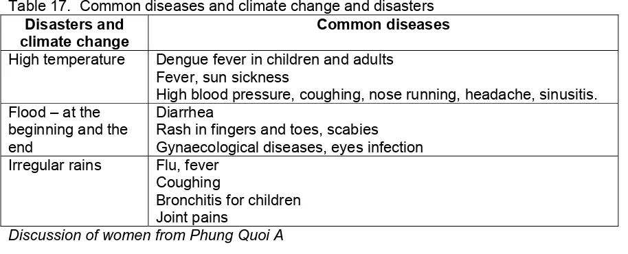
5.2 WOMEN’s GROUPS NEEDS FOR CHILDCARE DURING FLOOD SEASON – the great concern of mothers in Thanh An township (Vinh Thanh District): The discussion among women who have small children in Phung Quoi A ward (Thanh An township) pointed out a critical need for child care during the flood season. Even though Thanh An township has a kindergarten, poor families could not afford the expense (300,000 VND per month for a child). Four years ago, the ward started “flood season” child care groups with financial support from the government. This model was highly appreciated by local mothers. However, by the time of this assessment, only one among 3 child care groups in Phung Quoi A ward sustains due to the suspension of the government support.
Mothers who have small children at the child care group 1, Phung Quoi A ward insisted on having the child care group re-open. In addition, there are proposals on building the fence or surrounding walls for the school, paving the school yard (currently it is a sand lot); providing toys, clean water supply, mats, cooking utensils etc.
Through discussion with women in Thanh An Town, it is found that the child care models are very nessessary in the flooding seasons. Some benefits can be seen:
• Poor women would be able to work without much worrying about their children. • Poor women would have more time to earn more income from fishing during the flood
season from August to October. Without child-care group, they would have to stay at home to take care of their children.
• Children were kept safer at child-care groups, particularly for children at pre-school age as they were kept away from the water. Child care teachers at Bo Bao group (the child care group which sustains until now) mentioned cases of children drown in the flood season before the establishment of these child care groups. With the child care group, there was no more drowning case reported.
• Children were kept safer at child-care groups, particularly for children at pre-school age as they were kept away from the water. Child care teachers at Bo Bao group (the child care group which sustains until now) mentioned cases of children drown in the flood season before the establishment of these child care groups. With the child care group, there was no more drowning case reported.
Sharing from mothers and kindergarten teachers about child care groups in the flood season
Mothers who have small children at the child care group 1, Phung Quoi A ward insisted on having the child care group re-open. In addition, there are proposals on building the fence or surrounding walls for the school, paving the school yard (currently it is a sand lot); providing toys, clean water supply, mats, cooking utensils etc.,…
Critical problems reflected through both the group discussions and our observations were: - Sanitation: All child care groups do not have toilet. According to a teacher, they took the
children to the river – like local people here who mostly did not have toilet. - Nutrition as the subsidy was limited compared to food price.
- Safety as the surroundings of the child care location was also flooded or going to the river for instead of having a latrine implied a risk to the safety for children.
- Sustainability of childcare groups: At the moment, many of the childcare groups are not functional due to the lack of finance for the teachers and the children expenses. External dependence instead of community reliance or local intiatives causes the disruption of the model.
5.3 POOR WOMEN AND MEN HAVE LOW ACCESS TO CREDITS/FINANCIAL INSTITUTIONS
It was brought up in the discussion with local women and staff of the women’s union in both Thanh An township and Bui Huu Nghia ward that it was difficult for the poor – especially poor women – to access to available preferential- interest credit. Poor people do not have land or any significant property to put in security or mortgage as required by all commercial banks. Poor people or households usually access to governmental credit through the Vietnam Bank for Social Policies – which offer loans guaranteed through local mass associations such as the Farmer’s Union, the Women’s Union, Veteran’s Association or Youth’s Union. Thanh An’s Women Union managed three programmes:
- Programme for poor households offers a maximum loan of 10 million VND and minimum of 2 million VND in two years, with an interest of 0.65 % ;
- Programme on Water Supply and Sanitation offers a loan of 8 million VND in five years with an interest of 0.9 % for building water storage and latrine; and
- Education loan for students in 4-5 years offers a total of 22 million VND (6-8 million VND per year per student).
However, both poor men and women informed the assessment team that many people could not get these loans since funds were not available.
Women and men are in need for loans
The family of Nguyen Van Nam and Truong Thi Tuyen living by the Canal 16, Phung Quoi A ward is classified as a poor household. Tuyen received a two-year loan of four million Vietnamese dongs from the Vietnam Bank for Social Policies with the guarantee of the local Women’s Union. Every quarter, she pays an interest of nearly 80,000 dongs. The head of the local Women’s Union collects this interest from Tuyen.
account for their own – they used to have to pay a higher price for sharing electricity with their neighbors.
After selling the second pair of pigs, Tuyen paid back four million dongs to the Bank of Social Policy. The couple wanted to get another to continue raising more pigs. But Tuyen is not sure if she can get another loan, she knows many poor people lined up for a limited funding. She wants a loan of 10,000,000 dongs. One million to repair and enlarge the pig case, 4,200,000 to buy six small pigs and the rest will be for raising them. Tuyen has never been trained in raising pig.
The assessment has pointed out the following findings related to credit access:
• The government’s credit provision for the poor does not meet their demands. In some cases of refusal, the bank and/or local associations did not provide guarantee for some households as these organizations did not see the possibility of paying back these loans or if the household would not be able to generate income from the loan. However, a number of local women said the process of screening and approval was not really fair as some households got the loan, while the others in similar conditions did not.
• Loans from the Vietnam Bank for Social Policies are relatively small, from 5 to 7 million dongs. However, due to a large demand, these loans are separated into smaller loans (4 millions). The duration of the loan is also considerable short (one year) which is not efficient. Local people proposed a larger size and longer duration of loans – up to three years – for the poor.
• According to local authorities and staff, loans were given in a package with technical training or household economics (e.g. training on raising pigs). In fact, some households participated in the assessment did not attend these trainings. They met difficulties in dealing with pandemic. Some households said they could not attend those trainings as the venue was too far. Other households said they were not invited as the number of participants in each training course was limited.
• A low awareness on sanitation was observed among households asking for loan for livestock (mostly for raising pigs) in Phung Quoi A ward (Thanh An township) and Con Son island (Bui Huu Nghia ward) – where local people live mostly on agriculture. As most people do not have much land, they build the cage for pigs next to their house and the sanitation was not proper.
The head of the Women’s Union in Phung Quoi A ward described a model of ‘capital accumulation group’ running from February 2006. This model did not require mortgage or guarantee like loans from the bank. This model of self-help group also strengthened the connection among the local women. However, the size of the fund accumulated through this model was relatively small compare to the demand for livestock (e.g. raising pigs). In addition, if this initiative will be multiplied, it should be complemented with the techinical trainings and coaching and could be emerged with other activities by the Women’s Union such as raising awareness on women’s rights besides providing loan.
Capital accumulation group (Tổ hùn vốn)
5.4 CHALLENGES FOR MIGRANT WORKERS, ESPECIALLY FOR FAMILIES WITH SMALL CHILDREN
Tran Thi Hong Xuan, a woman of age 29 from Soc Trang Province is married to a man from Dong Thap province.
She has two children, one is nice years old and the other is eight months. The couple moved to Can Tho in 2008. Her husband sells sweet breads at O Mon district, about 25 km from the centre of Can Tho. She used to serve as a domestic maid, but now Xuan stays at home to take care of the small child. They rent a tiny room which does not have enough light: they had to carve two holes on the wall of the room and leave a hole on the roof to get some sun light. Their income is chancy at around one million dongs per month. They have to pay 350,000 dongs for rent. The coming school year for their first child will cost about one million to start (school fee, books and stationery, uniform, pupil insurance, etc.,) Xuan told us that during the three months of the rainy season, they did not have enough food. She borrowed 500,000 dongs from the landlord for a month and had to pay back 600,000 dongs. These recent months, the small baby got sick. It cost 400,000 to buy medicine and take the baby to the hospital three times. Her baby does not have the ticket (for small children to get free health care) because their household is registered in Soc Trang. The couple have never been invited to any meeting of the local community.
Xuan wants her first child to get school fee waiver as other poor households could have, and the second child to get free health care like other children under six years old.
(Tran Thi Hong Xuan, rental house range, Area 3, Bui Huu Nghia ward)
The case of Xuan implied challenges and vulnerability that migrant workers are facing: • Lack of access to public services such as health care and education due to without
household registration at the local administrative unit of the destination. The migrants have to return to their home province to get a verification and recommendation to forward the patient to the hospitals in the destination. However, they could not afford these expenses including traveling cost. This leads to the fact that even though the government has the policy on providing free health care for children under the age of six, in fact these migrant households do not benefit from this policy.
• Migrant households often do not have secured jobs or employment. They work as vendors or manure labour with very low income. These are poor households do not benefit from any of the government’s social policies for the poor as these policies do not address migrants as a target group. They often have to pay a higher price for utilities as set by landlords.
• Local authorities said they are not responsible for migrants; only local police keep track on the number, the list of full name and origin (as reported by landlords) for security control in the area. In fact, migrants’ concerns or problems are not “scope of responsibility” by local authorities where they migrate to.
• Migrants do not participate in any of those activities organized by the local people. This separation restricts access to information of these migrants and their opportunity of participating in the local life and community events as well as accessing important available local resources and increasing social capitals.
5.5 CHALLENGES FOR SINGLE WOMEN AS HEAD OF THE HOUSEHOLDS
Why haven’t women as head of poor households got grant to build their houses?
Tran Thi Huong is 47 years old. Her husband died in 1999 from a sickness. She now lives with her two daughters, one is at ninth grade and the other is at seventh grade. Huong does not have land to plant rice. She washes dishes for a local restaurant for 30,000 dongs per day. Her house is tottering, the earth floor is chappy, the roof made of leaves is full of holes. “Rain often comes through my dilapidated house”, she said. During the flood season, water came up to her door. Without a pirogue, she and her two children had to wade 300 meters in water up to their waist to the main road to go to school or to work.
Huong said, once a staff from the ward mentioned to her that the government would support poor households like hers to build a new house, but she had to pay 3 million in advance to a fund which was not clear for her what for. She said, it was hard for her family than other poor families (with a man as the head of the household). A man could socialize more and handle relations with local authorities better.
The assessment showed that the most vulnerable groups among the poor people are single mothers and elderly. They share common characteristics as almost other poor people such as landless, having unsecured employment, low income, having health problems... In addition, single poor women have very limited social capital which affects their capacity and opportunity to participate in and benefit from the government’s programmes for the poor. While the demand for such programmes is very high for both the poor and nearly poor groups, it’s usually done in the way that local authorities and social associations make a list of poor people, which is discussed in the village meeting and then finally submit to higher level for approval of the list (who will benefit form the government’s policies for the poor). Needs from the group of women
(i) Provide water supply or support to build wells.
(ii) Support finance to resume child care groups during the flood season (iii) Have a pirogue to take children to schools
(iv) Provide more loans or microcredit (v) Clean up pollution and water source 6. HCVA IN BINH THUY DISTRICT
6.1 HAZARDS IN BINH THUY DISTRICT AND IMPACTS
At Binh Thuy District, the disasters were identified and arranged with the force of the effect to local livelihood. The result was showed in the Table 2.
Table 2: The disasters and their effect strength ranked by local authorities Ranking
No. Disasters
District Bui Huu Nghia Section 1 Section 3
1 Flood and High tide 1 1 1 2
2 Landslide and erosion 2
3 Environmental pollution 2 1
Ranking No. Disasters
District Bui Huu Nghia Section 1 Section 3
5 Cyclone 4 3 3
6 Storm 3 4 3
7 Lighter and Thunder 5
8 Fire 5
The results on the Table 2 give that when the flood comes and combines with high tide would cause the heavy impacts to area and local livelihood. At the flood season, although the water level is higher than other time but it has not caused the damage. When the flood time combines with high tide, the high water level will be higher and higher and make the waterlogged. Fortunately, the areas near the Mekong River will not be waterlogged for long time because of the effect of semidiurnal tide - when the low tide the water will be driven out. The maximum period of water logging would be about 6 hours per day if that area was covered by water. The water logging could cause the damage to the agriculture particularly to orchard and gardens and then to losee the household income, that would be the first and largest damage.
The landslide and erosion would result in the loss of some land and cause damages to the area. So the damage of landslide would consider the disaster with the second potential harm.
The environmental pollution is considered to be the main harmful source because it causes the damage to survival environment including the resources especially the water resources is used for domestic consuptiom. At section 3 of Bui Huu Nghia ward, waste from the enterprises and manufactory around affects the local people’s lives. According to the local community, currently they perceive that environment pollution in their area cause the most damages to their lives. At section 1 (Son river islet), there are no water supply system, the local community has to use water on Hau river for domestic use. Water pollution from intensive Pangasius catfish aquaculture is considered to be the second source of water pollution in the area.
The hot air and unusual rainfall is considered to be more the harmful source to the lives and livelihoods of the local people.
Cyclone and typhoon can be arranged the third or fourth damage depending on the particular area. All of the informants agreed that although the damage of cyclone and typhoon is heavy but their probability is low and in short period so their damages are not much. The local authorities and community’s assessment explained that their experience on the typhoon and cyclone prevention is very low. This is one of the unprepared situation of the Mekong delta people because the climate change would cause the irregular changing on the climate and weather, and that cyclones and typhoons will appear more often too and then the people would suffer from further damages when they are hit unprepared.
Thunder and fire are ranked the lowest damage level because their damages are small scale.
Landslide/erosion in the islets or other places do not happen in the flood season, it might show that flood is not the main cause for the erosion and landslide in the area. There should be further research on this to provide appropriate measure to prevent this happing.
Month Disasters
Jan Feb Mar Apr May Jun Jul Aug Sep Oct Nov Dec Flood and High
tide Cyclone Storm
Landslie/ Erosion Lighter and Thunder
High temperature
Figure. 6. Disaster Calendar
In Binh Thuy (Red band) and Bui Huu Nghia (Blue Band)
Environment pollution is not one of the natural disasters but it is causing a lot of problems for the local people in Binh Thuy District. There are three pollution sources in Binh Thuy: i) industrial activities ii) water and domestic waste water iii) water and waste from aquaculture activities along the rivers. According to the group discussions at all levels, industrial areas such as Tra Noc 1, 2 although they claimed to have a waste wate treatment but this either does not work regularly or ineffectively therefore the waste water comes into the river and pollutes the river. Domestic water also goes straight into the rivers and canals without any treatment. The percentage of the households without latrines is quite high, around 30% in the whole district, especially in the outer areas, and this also makes the pollution worse. Areas along Hau River have favourable conditions for raising river fish, and the main fish is catfish all year around. The fact that waste water from fish raising ponds goes straight into the rivers without any treatment causes serious water pollution for the local people, especially the pollution in the small rivers/canals, directly affecting water sources and hygines of local people living along the rivers.
Main damages in Binh Thuy
According to historical profile, from 2004 up to now, main hazards have happened in the district include river erosion, floods combined with high tide, cyclones and storms. Due to the natural nature of the area with weak earthern foundation, with Hau River and busy canals systems, during the flood season, water level rises up high with the strong currents can cause erosion, affecting the lives and production of the local people.
In table 3, the damages related to agriculture production, and lands of the areas along the rivers are considered to be the main ones in most of the wards in the district. Most serious damages are in Son islet, Khuong islet of Bui Huu Nghia ward.
Table 3. Disasters happened in Bui Huu Nghia since 2004
Year Disasters Affected areas Damages and causes 2004-2007 River
erosion
Bùi Hữu Nghĩa (Cồn Sơn) ward