M
YANMAR
C
OUNTRY
R
EPORT
Eric Vaughan
, Mercy Corps Myanmar
ESPA/ACCCRN Myanmar Country Report: Eric Vaughan
Acknowledgements ... 2
Summary ... 3
Background ... 4
Urbanization Trends ... 5
Urban Hazard Profile ... 6
The diversity of problems between urban centres and surrounding ecosystems ... 6
Overview of Urban Land Use Planning Institutions ... 9
Information Demand ... 15
Dawei – Insights from an area experiencing extreme urban growth ... 16
Recommendations ... 17
References ... 20
A
CKNOWLEDGEMENTS
ESPA/ACCCRN Myanmar Country Report: Eric Vaughan
S
UMMARY
Myanmar is experiencing explosive urban growth, particularly in primary and secondary economic growth centres as set by union-level planning. Most of these are at significant risk to flooding, earthquakes, with many regularly impacted by coastal storms. As a result, coastal cities (7 of the 15 largest), are at risk to climate change. For example, three
tropical storms struck Myanmar in 2016.
In addition, most cities are struggling to provide reliable basic services to existing
residents. When coupled with rapid urbanization, the result is a continuous struggle to hit a moving target and city planners prioritize short term gains in service coverage to
maintain and demonstrate progress. Urban planners rely on international donors to provide the evidence-base for planning decisions rather than researchers. With existing low levels of existing capacity to plan effectively and the funds to finance them,
International donors such as JICA and the World Bank have been eager to provide support. However, the result is solutions that are limited to hard infrastructure and fail to include options that address the long-term risks to ecosystems and associated socio-economic losses. moreover, existing urban planning and development policies,
regulations, and enforcement systems do not provide clear guidance on how to account for risks to ecosystems nor do they effectively protect them at scale.
As a result, there is little demand for information about ecosystem services in urban areas and the associated risks related to urbanization and climate change. Though some
international actors such as UNHABITAT have supported vision [1] for how to think about urban planning in a way that includes green and blue infrastructure, actual alternative options to hard infrastructure have yet to be developed and presented in a comparable way. Green spaces are largely perceived to provide beautification and not mitigate environmental risk. Additionally, there is little evidence that urban planner in Myanmar are exploring zoning options for supporting ecosystem functions that reduce things like flood risk.
Generating more demand among urban planners in Myanmar will take time, yet Myanmar is in a somewhat unique position in that it can benefit from the lessons and experiences of its neighbours. Supporting research that identify strategies that address risks to greater urban ecosystems must be framed in a way that responds to the pressing needs of Myanmar urban planners. Some potential entry points to greater engagement between urban planners and researchers are as follows:
ESPA/ACCCRN Myanmar Country Report: Eric Vaughan
• To shift the prioritization of infrastructure options that enhance ecosystem services, urban planners must know how to assess ecosystem risk. The challenge is to
connect indicators of ecosystem function to wellbeing indicators that reflect urban service delivery goals.
• Considering the pressure urban planners face in Myanmar to meet fast growing demand for urban services (power, water, sanitation, housing, etc.), there is desperate need for service options that do so while also addressing ecosystem risks. However, these options must be presented in a comparable way to physical infrastructure, which means framing them in terms that highlight social and
economic benefits.
• Urban planners in Myanmar face intense pressure to delivery immediate growth in service delivery. Urban services must demonstrate both short-term gains while building longer-term environmental resilience to be viable alternatives.
• To better manage flood risk, land use planning through zoning and setting aside conservation areas, particularly in fragile peri-urban areas or boundary areas
surrounding urban lands will likely add substantial benefit. Yet, these policies must be presented in way that shows social economic benefit.
• Civil society is in a nascent state in Myanmar because of decades of military rule. Researchers and development agencies would be wise to build the capacity of local advocacy groups to better support urban ecosystem services, particularly connected to the specific aspects of social and economic welfare that resonate in different Myanmar cities.
• Regulatory and codes are not well enforced in Myanmar. Though there seems to be progress in developing regulations and codes that may lead to more resilient environmental outcomes, these need teeth. Efforts at demonstrating the value of enforcement can be couples with a strengthened civil society to both mount the pressure to do so, while making the case for the budget allocations that are necessary (again, against the costs of inaction).
B
ACKGROUND
This country scoping study aims to highlight the existing evidence base for the threats and opportunities in the Myanmar urban context through ecosystem services and dis/services, and identification of related information supply and demand needed to address as part of building inclusive urban resilience.
The Myanmar evidence-base contributes toward:
ESPA/ACCCRN Myanmar Country Report: Eric Vaughan
• Identifying critical trans-boundary governance gaps between cities and
surrounding ecosystem administrations, enabling disaster risk reduction and SDGs solutions for cities from threats outside of their governance boundaries.
• Providing a platform for ESPA and other research platforms to ground science in demand-driven applications seeking to build urban resilience with inclusive, pro-poor outcomes.
• Building bridges across the Asia between those supplying and those seeking evidence-based information for advocacy and action in building urban resilient agendas.
• Contributing to emerging discourse on access to newly emerging climate funds beginning to invest in urban infrastructure.
• Identifying priorities for ACCCRN and ESPA to access resources for based on findings.
U
RBANIZATION
T
RENDS
Myanmar, with a population of around 51.4 million, has the lowest Gross Domestic Product (GDP) per capita and one of the highest poverty rates in Southeast Asia. Poverty is officially estimated at 37.5 percent [2]. Myanmar is also the largest country in mainland Southeast Asia and contains abundant natural resources.
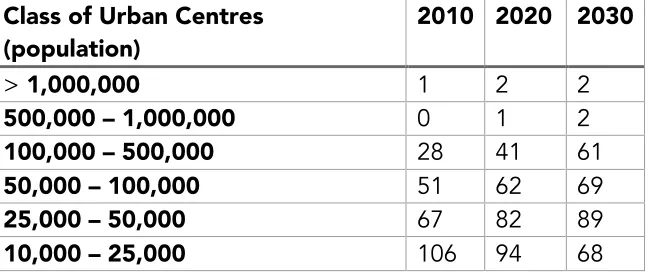
Long military rule, conflict in the border areas, centrally planned and executed policies, and international isolation explain its low level of development. With social and economic reforms in place since 20012 and a democratically elected government in place as of 2015, Myanmar is currently developing at a rapid pace. This, among other things, is resulting in urbanization to occur at a rapid clip. It is cantered in the primary cities of Yangon and Mandalay along with national and regional growth cities. By 2030, the number of cities with between 100,000 to 500,000 residents is expected to more than double, from 28 to 61.
Table 1: MHSHS secondary city projections (note rise in 100,000 - 500,000 secondary cities). Dept. of Human Settlements and Housing Development 2014
Class of Urban Centres (population)
2010 2020 2030
> 1,000,000 1 2 2
500,000 – 1,000,000 0 1 2
100,000 – 500,000 28 41 61
50,000 – 100,000 51 62 69
25,000 – 50,000 67 82 89
ESPA/ACCCRN Myanmar Country Report: Eric Vaughan
< 10,000 110 82 68
Total 365 365 365
Myanmar’s national ‘Concept of Concentrated and Decentralization Development Strategy’ places Yangon and Mandalay at the centre of ‘Two-Polar Development’ with National Economic Growth Centres also including Sittwe and Dawei. Finally, there are Secondary Regional Growth Centres along regional trade corridors.
Figure 1: Most growth centers are in lower lying, including coastal, areas with the two main exceptions being in on the Shan Plateau – Department of Human Settlements and Housing Development 2014 [3]
U
RBAN
H
AZARD
P
ROFILE
The diversity of problems between urban centres and surrounding
ecosystems
Myanmar’s geographic context is wildly diverse. It ranges from one of the largest deltas in the world to mountains above 5,000 m. Average rainfall ranges from as little as 30 cm to 500 cm per year. The Ayeyarwady is Myanmar’s largest river basin and has been
described as the heart of the nation. The basin accounts for about 60 percent of
Myanmar’s landmass and is home to some 70 percent of its population. The Ayeyarwady is a river of global proportions, with an average annual flow of over 400 billion cubic
Capital City
(Administrative, Transport & Logistic Hub )
Secondary Regional Growth center
Other Growth center
Town with more then 50000 inhabitants
Main Corridor
Emerging Regional Corridor Major Communication Axis
National Economic Growth Centre
(SEZ, Port, Int. Airport, Trading, Financial )
Two-Polar Development Concept (Yangon & Mandalay)
CONCEPT OF CONCENTRATED AND
DECENTRALIZATION DEVELOPMENT STRATEGY
NATION SPATIAL DEVELOPMENT CONCEPT
ESPA/ACCCRN Myanmar Country Report: Eric Vaughan
meters, or roughly 85 percent of the Mekong. Groundwater resources in the basin are believed to be equivalent to at least 50 percent of the basin’s current surface water storage volume, and countrywide as high as perhaps 495 billion cubic meters.
The river runs from the mountain ranges in the north, through the agriculturally important dry zone in the middle basin, to the productive yet fragile delta in the south. Due to the relatively high share of the population in the dry zone and the delta, these two regions account for nearly two-thirds of the poor in Myanmar.
Because of this diversity, the hazard profile varies by region. Myanmar is highly vulnerable to hydroclimate extremes, with great exposure to cyclones, a quarter of the country
facing flood risk (threatening 36% of the coastal population) and many areas, particularly in the Dry Zone and into the northwest, experiencing droughts. Upland mountain areas are exposed to landslides, while lowland areas are exposed to flooding. However, because most upland areas of Myanmar are in remote and historically marginalized, development of the primary and secondary urban centres are primarily centred in lowland areas either in the Dry Zone or near to the coast.
Table 2: Myanmar has several types of hazards with Cyclone Nargis most lethal [4]
Type Date Total Deaths
Storm 2 May 2008 138,366
Storm 19 May 2004 236
Flood 19 October 2011 151
Earthquake 24 March 2011 74
Earthquake 26 December 2004 71
Landslide 17 June 2010 68
Storm 22 October 2010 45
Earthquake 11 November 2012 38
Storm 29 April 2006 34
Except for landslides, these types of hazards are highly relevant to the areas where primary and secondary cities are likely to be located. Of note; urbanisation is most intense along major rivers, which are the historic transportation routes. This makes a significant proportion of the urban population to flood risk. As a result, floods affect urban populations every year. For example, in 2015, widespread flooding occurred across
thousands of miles of the Ayeyarwady River system:
Severe flooding in Myanmar began in July 2015 and continued into September, affecting
12 of the country's 14 states, resulting in about 103 deaths[3] and affecting up to
ESPA/ACCCRN Myanmar Country Report: Eric Vaughan
Torrential rains that began on 16 July destroyed farmland, roads, rail tracks, bridges and houses, [5] leading the government to declare a state of emergency on 30 July in the four
worst-hit regions in the west. Moreover, 15,239 houses were destroyed, according to
OCHA figures.— Magway Division, Sagaing Division, Chin State and Rakhine State. [5]
Figure 2: Flooding in Kalay, Sagaing, 2015
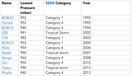
Myanmar’s extensive coastline and delta region put many primary and secondary cities at risk from coastal storms [6], including cyclones, which strike Myanmar every 1 – 2 years on average.
Table 3: a list of the most recent cyclonic storms to strike Myanmar
Name Lowest
Pressure (mbar)
SSHS Category Year
BOB 01 992 Category 1 1992
Forrest 952 Category 4 1992
BOB 01 940 Category 4 1994
02B 991 Tropical Storm 2002
01B 982 Category 1 2003
BOB 01 952 Category 1 2004
Mala 954 Category 4 2006
Akash 990 Tropical storm 2007
Nargis 962 Category 4 2008
Giri 950 Category 4 2010
Viyaru 990 Tropical storm 2013
ESPA/ACCCRN Myanmar Country Report: Eric Vaughan Komen 986 Tropical storm 2015
Roanu 983 Tropical storm 2016 Dianmu 985 Tropical storm 2016 Kyant 998 Tropical storm 2016
Aside from earthquakes, climate change is expected to increase all types of risk identified above. Over the past 4 – 5 decades, Myanmar has experienced an upward trend in
average and high temperatures and decreases in the monsoon duration. There does not appear to have been significant trends in total rainfall. Some recent research suggests that pre-monsoon climate patterns have led to increases in May precipitation (thus possibly earlier monsoon onset) and increased and more intense cyclone activity since 1979. While the upward trend for temperature is clear, more research and analysis is necessary to understand rainfall and monsoon trends over the past decades.
Hydroclimate extremes are expected to become more frequent and/intense due to climate change. Average temperatures are expected to rise 1-4C by the end of the century and rainfall is project to increase around 10% (mostly concentrated in fewer rainfall days and more extreme events) [7]. However, these findings remain quite general and there is a recognized need to regionalize climate research efforts, including through downscaled projections at a sub-national level.
Development also plays a role in elevating hazard risk. For example, 83% of Mangrove forests in the Delta region have been lost because of agricultural intensification, demand for timber, and urbanization. This has reduced the ability of the delta ecosystem to absorb storm surges as well as other detrimental effects on agricultural and fishing livelihoods. The long-term impacts of Cyclone Nargis highlight an important implication of Myanmar’s coastal hazard risk; that being, it caused extensive damage to critical flood protection infrastructure. As a result, nearly ten years on, many delta areas or more vulnerable to storm surges than before.
Prior to Cyclone Nargis, there were some 318-flood protection works, both government (88%) and private (12%), protecting a total of 1.2 million ha of cultivable land. Many of these structures were badly damaged during Cyclone Nargis, leaving much of the most productive part of the country vulnerable to catastrophic weather impacts.’ [8]
O
VERVIEW OF
U
RBAN
L
AND
U
SE
P
LANNING
I
NSTITUTIONS
ESPA/ACCCRN Myanmar Country Report: Eric Vaughan
falls under the responsibility of Regional Governments and City Development Committees.
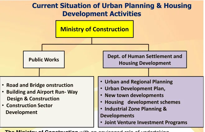
Figure 3: At the Union-level, the Ministry of Construction has overall responsibility for Urban land use planning and development - Department of Human Settlements and Housing Development Ministry of Construction 2014
Union-level institutional responsibilities related to different hazards are divided among several ministries (Figure 5 [4]). However, master planning at the municipal level must also review and analyse ‘environmental conditions’ [9].
Current Situation of Urban Planning & Housing Development Activities
Public Works Dept. of Human Settlement and
Housing Development
• Road and Bridge onstruction
• Building and Airport Run- Way
• Industrial Zone Planning & Developments
• Joint Venture Investment Programs
The Ministry of Construction with an envisaged role of undertaking
Urban Planning, Housing Development and construction of Road & Bridge Infrastructure throughout the nation
ESPA/ACCCRN Myanmar Country Report: Eric Vaughan Figure 4: Ministries responsible for various hazards
The institutional connections between union-level ministries and city development
committees appears limited (but could use deeper investigation). One recent opportunity to foster these linkages is through a recent World Bank credit. The Department of
Meteorology and Hydrology has accepted a 100 million USD World Bank credit through the ‘Ayeyarwady Integrated River Basin Management Project’. With this financing,
components include increased institutional capacity in IWRM, a new decision-support system to support IWRM and hydro-meteorology observation infrastructure and systems including service delivery. It is not clear to what extent urban institutions will feed into the development of these systems or connect these updated information services with urban planning and management systems. Yet, with so many urban centres exposed to floods (most recently in 2015) these connections seem critical.
Building codes play an important role in environmental risk mitigation. These can help to ensure that buildings are constructed to withstand earthquakes or effectively connected to sewage networks. About building codes:
Myanmar’s current building code dates from 2012 when there were few, if any, high-rise buildings in the country. As a result, the majority of the larger projects that have been built in the country in recent years have tended to follow either US or British guidelines.
Amendments to the code have been under way since 2013 and apply to all buildings, with a special focus on the construction of municipal buildings, such as schools and hospitals. Also to be included in the code are fire safety, extreme weather and natural disaster measures. While there have been no big earthquakes for some time, Yangon is vulnerable to seismic activity. In 1930 the 7.3 magnitude Bago earthquake resulted in 50 fatalities at a time when the city’s population was only 400,000. Cyclone Nargis, which tore through southern Myanmar in 2008 exposed the country’s vulnerability to natural disasters.
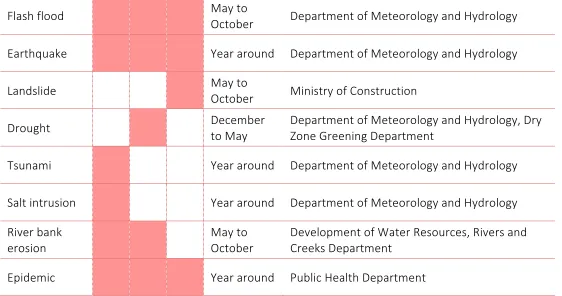
Flash!flood!! ! ! ! May!to!
October! Department!of!Meteorology!and!Hydrology! Earthquake! ! ! ! Year!around! Department!of!Meteorology!and!Hydrology! Landslide!! ! ! ! May!to!
Tsunami!! ! ! ! Year!around! Department!of!Meteorology!and!Hydrology! Salt!intrusion!! ! ! ! Year!around! Department!of!Meteorology!and!Hydrology! River!bank!
ESPA/ACCCRN Myanmar Country Report: Eric Vaughan
The new code will require approval from the Ministry of Construction before it can be implemented, but U Win Khaing told OBG he was confident this would be achieved in early 2016, and some architects and contractors have already begun to employ some of its recommendations, according to the local press [10].
This code is currently in provisional form and is reported to include several elements that may promote environmental sustainability [11]:
The same article reports that regulatory improvements are also in process, indicating that there is likely ongoing opportunity to bypass good construction practices:
Other laws governing construction date from Myanmar’s colonial past and are also in the process of being updated, while city masterplans aim to ensure proper zoning of areas for industrial, commercial or residential use. U Win Khaing told OBG that he expects the new regulations to improve the quality of buildings and prevent construction companies from cutting corners. “In three to four years’ time, builders will just have to follow the rules,” he said. “The cost may be a little higher, but we should have better quality buildings, fewer issues on safety, improved standards to follow and proper materials.” [10]
The largest city in Myanmar is Yangon, which has received significant support in the recent years to put in place a long-term development plan (for 11.7 million anticipated residents by the year 2040). This plan provides several insights into the demand for information related to ecosystem services and how master planning accounts for
ecosystem services [9].The plan was financed and carried out by the Japan International Cooperation Agency (JICA) in collaboration with the Yangon City Development
Committee (YCDC).
The plan notes that earthquakes, cyclones, and floods are common ‘disasters’ Yangon is exposed to but only includes a brief analysis of some of these risks, mostly flooding. It
Urban Resilience Initiatives Myanmar National Building Code (From provisional 2012 to 2015…) o Green/environmentally friendly design,
construction and operation
o Zoning requirements, environmental control
and land law - integrating environmental sustainability
o Energy conservation and efficiency (not much
in Provisional 2012, to include in 2015)
o Urban Aesthetics control
o Structural integrity for disaster resistance o Accessibility for disable and elderly
population, and
o Building materials and services, carbon
footprint of buildings, and water conservation
ESPA/ACCCRN Myanmar Country Report: Eric Vaughan
reports that floods happen ‘almost every year’ and ‘fringe areas of Greater Yangon have rapid population growth of 3% per year… lie in the lowland area and have disaster risks due to flooding and drainage congestion during high tide’. Moreover, it notes that 42% of households report being flooded every year. It also notes that ‘drainage congestion problem in Greater Yangon is complicated. Several conditions, i.e. harsh natural
conditions, rapid urbanization and poor capacity of drainage system, cause the problem’.
To deal with flood risk for example, the plan calls for investments in a storm water drainage system and the development of several new parks as the city grows. The changes in existing ecosystem functions (flood management and air quality for example) will be substantial as the build-up areas of Yangon dramatically changes between now and 2040:
ESPA/ACCCRN Myanmar Country Report: Eric Vaughan
Aside from identifying methods for dealing with flood risk, the Yangon Master Plan does not articulate how it will incorporate risk management systems into the development process. A ‘Strategic Environmental Assessment’ was carried out as a part of the planning process looking at risks the plan pose in ‘social, natural environment, and pollution’. As a result, general types of mitigation measures are ‘recommended’. But any mitigation measures would be reactive rather than proactive - meaning that water, air, and noise might be monitored, but ecosystem functions that support clean water, clean air, unobtrusive light and noise pollution, and flood protections are not reflected in the designs. This could result not only in missed opportunities to optimize socio-economic benefits, but design options that comprise Master Plan objectives. These missed opportunities are conditions that many existing cities This is something that cities like Hoboken (USA) are only now retroactively addressing [13]. In Myanmar, there is an
opportunity to avoid the mistakes of previous urbanization planning. One reason this may be the case is that it reflects the thinking of JICA, which developed the plan. As one JICA senior representative noted:
We thought our knowledge and experience would be an asset when designing and implementing a development plan for Myanmar. As for how Japan benefits, Japanese companies are interested in investing in upcoming infrastructure projects in Yangon. So, for example, Japan can provide grant aid to Yangon for the projects, and Yangon may choose to award the contracts to Japanese companies. The benefits go both ways [14].
It can also be challenging to avoid short term thinking under the pressure of rapid urbanization. In Yangon, this is reflected in YCDC’s current transportation priorities. For example, it has been to increase the capacity of roads by building flyovers over
prioritizing light railway options [14] (the flyovers make it more physically difficult to install rapid transit solutions). In this case, the compounding benefits from a quality of life
perspective conflict with immediate pressures to deliver services.
With the exception of a modest investment by the 100 Resilient Cities Initiative in Mandalay, there is no comprehensive disaster risk guidance in Myanmar to address disaster and climate risk into the urban planning process [11]. There is a National
Adaptation Plan of Action [15], but it is largely neglects urban issues. Its hazard analysis only mentions flood risk to urban areas. Its action plan includes support to urban areas in two ways (increased water supply around Naypyidaw and development of flood early warning systems for lowland areas). This means that as rapid urbanization continues and new secondary cities emerge at scale, there is a risk of a continuation of reactive
mitigation measures put in place against ecosystem degradation. Several noted
ESPA/ACCCRN Myanmar Country Report: Eric Vaughan
At the time of printing, UNHABITAT reported that the Ministry of Construction was currently in process of ‘preparing township development plans for 81 cities with limited manpower and technical capacity. The majority of these plans are ready and pending approval from the Ministry of Construction. However, these plans can clearly be improved upon by applying sustainable urban planning principles.’ [1]
UNHABITAT has been active in Myanmar’s urban resilience space and aims to engage in these development processes by for example, releasing Guidelines for Urban Planning (Prepared for the Republic of the Union of Myanmar) [1]. This guidance, amongst other progressive concepts identifies the importance of green/blue networks:
Consider ecosystem and ecological dynamics as important spatial elements and integrate this perspective in planning at different scales. Identify, revitalize, protect and produce high-quality public and green spaces with special ecological or heritage value, to avoid the creation of heat islands, protect the local biodiversity and support the creation of multifunctional public green spaces, such as wetlands for rainwater retention and absorption.
This overview outlines issues and, to some extent’ actors engaged in urban planning in Myanmar and the extent to which ecosystem services are included in existing planning processes. This is a time of significant transition for Myanmar. As a result, there is great opportunity to promote resilient development proactively rather than costlier and less flexible reactive options. The next step in understanding this context would be actor, network, and influence mapping to understand the social, political, and economic structures, both formal and informal that move urban development forward.
I
NFORMATION
D
EMAND
Primary and secondary urban centres in Myanmar are growing at a rapid pace and starting from a low-level of service delivery. Yangon, the most developed city in the country struggles to even maintain existing infrastructure [16], let alone keep pace with new demand. To date, demand for information regarding ecosystem services is limited because of several factors:
• Cities of all sizes in Myanmar are unable to meet existing demand for services while struggling to support high growth in demand due to rapid urbanization. This leads to the prioritization of short-term and rapid design options that do not mitigate risks to ecosystems.
ESPA/ACCCRN Myanmar Country Report: Eric Vaughan
services in a combined way. However, as discussed above, the results of this type of coupled support is that proposed solutions are limited to hard infrastructure and fail to include options that address the long-term risks to ecosystems and associated socio-economic losses. Urban planners therefore rely on international donors to provide the evidence-base for planning decisions rather than researchers.
• Because of how urban planning process is currently carried out, there are few connections between risk mitigation needs and prioritized development investments. Secondly, environmental risk activities are very broadly stated, conceptual, and underdeveloped. For example, in the Yangon Master Plan, risks are presented separately from development priorities and fail to provide a robust analysis of changes to ecologic functions and services within projected land-use changes and associated improvements to services. There is mention of an ‘environmental monitoring plan’, but no discussion of how it will be used to guide decisions.
• Existing urban planning and development policies, regulations, and
enforcement systems do not provide clear guidance on how to account for risks to ecosystems. The policy space may be an area where progress is being realized with support from actors such as UNHABITAT. However, changes to the way rules, laws, and codes are enforced must also be addressed.
• Though actors such as UNHABITAT have articulated a vision [1] for how to think about urban planning in a way that includes green and blue
infrastructure, actual alternative options to hard infrastructure have yet to be developed and presented in a comparable way.
• Zoning for supporting ecosystem functions that reduce issues like flood risk are not presented nor explored. Urban planners do not understand the social and economic trade-offs for example, of upstream undeveloped lands. This is even though it is quite possible to present these trade-offs in real economic terms, for example, in the cost of flood losses incurred.
Dawei – Insights from an area experiencing extreme urban growth
1The situation in Dawei, a ‘National Economic Growth Centre’ category city in Myanmar provides insights into the challenges associated with development and environmental risk. This context highlights the role of the private sector as well as the urgent need to equip civil society with the ability to advocate from community perspectives.
1
ESPA/ACCCRN Myanmar Country Report: Eric Vaughan
The Dawei Special Economic Zone (SEZ) with a deep-sea port, in Myanmar, is set to be one of the largest in Asia. Investment in Dawei (USD 50 billion through 2020) is being driven by a combination of Thai private and state investment, with Italian-Thai
Development Plc (ITD) the leading investor, with credit support from the International Finance Corporation and the World Bank. With the opening of the ASEAN Economic Community (AEC), a highway, railway, and oil and gas pipelines are also being
constructed linking Dawei to Thailand’s Map Tha Phut and to Quy Nhon in Vietnam. The completed SEZ will include a deep-sea port, oil refinery, coal-fired and liquefied
petroleum gas power plants, steel mill, petrochemical complex, and other medium and light industries.
This represents a dramatic transformation of the ecological, social, and economic
landscape of the Dawei region and broader implications for Myanmar. Dawei City is not only experiencing rapid population growth, but also direct and indirect impacts from the development of the adjacent SEZ. Yet, there remains a significant gap in considering the institutional and regulatory mechanisms that will be required for managing the
transformation that the industrial estate will bring to the wider area – managing the demand for water and how this will be met; preventing impacts on air, groundwater and soil quality; ensuring transparency and proactive communication with the public; and maximizing economic benefits to the community.
Key barriers to the incorporation of social and environmental safeguards in this context of rapid growth and land-use transformation include not only limited knowledge of potential impacts and effective mitigation measures among local decision-makers, but also limited political will among investors and the local and national Thai and Myanmar governments. There is urgent need to enable stakeholders to (1) develop social and environmental safeguards as well as (2) foster advocacy that targets key decision-makers, notably in government, to throw their weight behind the establishment and enforcement of such safeguards. While the political situation surrounding the Dawei SEZ is complex, steps are urgently needed to ensure that communities in Dawei benefit from and are not negatively impacted by large-scale private sector investments.
R
ECOMMENDATIONS
ESPA/ACCCRN Myanmar Country Report: Eric Vaughan
Supporting research that identify strategies that address risks to greater urban
ecosystems must be framed in a way that responds to the pressing needs of Myanmar urban planners. Given the challenges identified in the previous section, some potential entry points to greater engagement between urban planners and researchers are as follows:
• Researchers need to be connected to the networks that engage urban planner in Myanmar. These also, include international donors such as JICA and UN-HABITAT, but also Universities engaged in this space such as the Thailand Environment Institute.
• To make better decisions, urban planners must know how to assess ecosystem risk. The challenge is to connect indicators of ecosystem function to wellbeing
indicators that reflect urban service delivery goals. Understanding the trade-offs between changes in ecosystem function and wellbeing outcomes they care about would go a long way in changing the development prioritization process.
• Considering the pressure urban planners face in Myanmar to meet fast growing demand for urban services (power, water, sanitation, housing, etc.), there is desperate need for service options that do so while also addressing ecosystem risks. However, these options must be presented in a comparable way to physical infrastructure, which means framing them in terms that highlight social and
economic benefits.
• Urban planners in Myanmar face intense pressure to delivery immediate growth in service delivery. They face the challenge of either infrastructure in disrepair or, more likely, built-up areas with no infrastructure. Development options that enhance ecosystem functions while also delivering urban services must provide short-term gains while building longer-term environmental resilience to be viable alternatives.
• For very tangible and relevant risks, such as flood management, land use planning through zoning and setting aside conservation areas, particularly in fragile peri-urban areas or boundary areas surrounding peri-urban lands. These policies must be presented in way that shows social economic benefit. This could be done in terms of avoided costs or other types of social and economic benefits to upstream or downstream populations (ideally both!). Tools such as ecosystem valuation models could present the means to do this.
• Civil society is in a nascent state in Myanmar because of decades of military rule. Researchers and development agencies would be wise to build the capacity of local advocacy groups to better support urban ecosystem services, particularly connected to the specific aspects of social and economic welfare that resonate in different Myanmar cities.
ESPA/ACCCRN Myanmar Country Report: Eric Vaughan
ESPA/ACCCRN Myanmar Country Report: Eric Vaughan
R
EFERENCES
1. UN Habitat, Guidelines for urban planning. Prepared for the the Republic of the
Union of Myanmar. 2016, UN Habitat: Nairobi, Kenya.
2. World Bank, Myanmar: Ending poverty and boosting shared prosperity in a time of
transition. 2014, World Bank: Yangon, Myanmar.
3. Hlaing, M.W.H. Myanmar perspectives on urban systems and development strategies. 2013; Available from:
https://www.google.co.uk/url?sa=t&rct=j&q=&esrc=s&source=web&cd=1&cad=rj
a&uact=8&ved=0ahUKEwjH2L-o37LTAhUNZVAKHXltCEcQFggnMAA&url=http%3A%2F%2Fwww.rksi.org%2Fsites
%2Fdefault%2Ffiles%2Fdocument%2F619%2Fpresentation-mya.pptx&usg=AFQjCNEYXQ_2AhhgnBqRAHEO2Z6fuvN9ew. 4. ADPC, Roadmap for risk asessment, Myanmar. 2015, ADPC. 5. Wikipedia. 2015 Myanmar floods. 2015; Available from:
https://en.wikipedia.org/wiki/2015_Myanmar_floods.
6. Wikipedia. List of tropical cyclones the affected Myanmar. 2017; Available from: https://en.wikipedia.org/wiki/List_of_tropical_cyclones_that_affected_Myanmar. 7. Baroang, K., Myanmar Bio-Physical Characterization: Summary Findings and Issues
to Explore. Center on Globalization and Sustainable Development, Earth Institute, Columbia University (New York) p, 2013. 8.
8. Driel, W.F.v. and T.A. Tauta, Vulnerability and Resilience Assessment of the
Ayeyarwady Delta in Myanmar. Full assessment phase. 2014, Delta Alliance.
9. JICA and YCDC, A strategic urban development plan of Greater Yangon. 2013, JICA.
10. Oxford Business Group, Improving regulations and standards for Myanmar's construction sector. 2016, Oxford Business Group.
11. Thu, K. Urban resilience in Myanmar. 2015; Available from:
https://www.google.com/url?sa=t&rct=j&q=&esrc=s&source=web&cd=1&ved=0a hUKEwi1y56fzajSAhUJvY8KHWR1BSMQFggdMAA&url=http%3A%2F%2Fwww.gre
en-lotus.org%2Fwp-content%2Fuploads%2F2015%2F03%2F01-Urban-UN_H_Myanmar-30-Jan-2.pptx&usg=AFQjCNECgW-iZvBZZvTOmR14.
12. Stanton-Geddes, Z. and J. Kyrspin-Watson, Using green infrastructure to control urban floods: a win-win for cities, in Sustainable Cities. 2016, World Bank.
13. Jaffe, E. The water next time. The Atlantic 2014; Available from:
https://www.theatlantic.com/magazine/archive/2014/12/the-water-next-time/382242/.
14. Gingold, N. Yabgon's development is key. The Irrawaddy 2013; Available from: https://www.irrawaddy.com/in-person/interview/yangons-development-is-key.html. 15. Government of Myanmar, Myanmar's National Adaptation Programme of Action
ESPA/ACCCRN Myanmar Country Report: Eric Vaughan
Committee, Ministry of Environmental Conservation and Forestry: Yangon, Myanmar.
16. Khant, A., Dazed and confused: The future of Rangoon's urban direction, in The
![Figure 1: Most growth centers are in lower lying, including coastal, areas with the two main exceptions being in on the Shan Plateau – Department of Human Settlements and Housing Development 2014 [3]](https://thumb-ap.123doks.com/thumbv2/123dok/2539847.1282821/6.595.62.505.212.530/figure-including-exceptions-plateau-department-settlements-housing-development.webp)
![Table 2: Myanmar has several types of hazards with Cyclone Nargis most lethal [4]](https://thumb-ap.123doks.com/thumbv2/123dok/2539847.1282821/7.595.51.508.396.571/table-myanmar-types-hazards-cyclone-nargis-lethal.webp)