www.nat-hazards-earth-syst-sci.net/11/1545/2011/ doi:10.5194/nhess-11-1545-2011
© Author(s) 2011. CC Attribution 3.0 License.
and Earth
System Sciences
Geomorphological and geochemical characterization of the 11
August 2008 mud volcano eruption at S. Barbara village (Sicily,
Italy) and its possible relationship with seismic activity
P. Madonia1, F. Grassa1, M. Cangemi2, and C. Musumeci3
1Istituto Nazionale di Geofisica e Vulcanologia, Sezione di Palermo, Via Ugo La Malfa 153, 90146 Palermo, Italia 2G¨ottingen Zentrum Geowissenschaften, Abteilung Geobiologie, Universit¨at G¨ottingen, Goldschmidtstrasse 3, 37077 G¨ottingen, Germany
3Istituto Nazionale di Geofisica e Vulcanologia, Sezione di Catania, Piazza Roma 2, 95123 Catania, Italia Received: 18 November 2010 – Revised: 14 March 2011 – Accepted: 23 March 2011 – Published: 24 May 2011
Abstract. On 11 August 2008 a paroxysmal eruption oc-curred at Santa Barbara mud volcano (MV), located close to Caltanissetta, one of the most densely populated cities of Sicily (Italy). An associated minor event took place on Au-gust 2009. Both the events caused severe damage to civil infrastructures located within a range of about 2 km from the eruptive vent. Geomorphological, geochemical, and seis-mological investigations were carried out for framing the events in the appropriate geodynamic context. Geomorpho-logical surveys recognized, in the immediate surrounding of the main emission point, two different families of processes and landforms: (i) ground deformations and (ii) changes in morphology and number of the fluid emitting vents. These processes were associated to a wider network of fractures, seemingly generated by the shock wave produced by the gas blast that occurred at the main paroxysm. Geochemical char-acterization allowed an estimation of the source of the fluids, or at least their last standing, at about 3 km depth. Finally, the close time relationships observed between anomalous in-crements of seismic activity and the two main paroxysmal events accounted for a possible common trigger for both the phenomena, even with different timing due to the very differ-ent initial conditions and characteristics of the two processes, i.e. seismogenesis and gas overloading.
Correspondence to:P. Madonia ([email protected])
1 Introduction
crease for a period of time after nearby earthquakes? Strain and stress perturbations from large earthquakes influence systems as groundwater aquifers, hydrocarbon or geother-mal systems, and magmatic volcanoes at long distances (e.g. Beresnev and Johnson, 1994; Gomberg and Davis, 1996; Linde and Sacks, 1998; Gomberg et al., 2001; Roeloffs et al., 2003). As reported in literature, earthquakes can also trigger large methane mud volcano eruptions (Abikh, 1863; Aliyev, 2004). Examples of mud volcano activity associ-ated with seismic activity have been documented in Pak-istan (Delisle et al., 2002), Romania (Baciu and Etiope, 2005), Italy (Martinelli and Dadomo, 2005), Turkmenistan (Guliyev and Feizullayev, 1995), and Japan (Chigira and Tanaka, 1997). Another example of earthquake/mud volcano relationship is represented by a mud volcano on the island of Baratang in the Middle Andaman islands that erupted just several minutes after the 2004 great Sumatra-Andaman Is-landsM=9 earthquake (Mellors et al., 2007). Finally, the previously mentioned Lusi mud volcano eruption is the sub-ject of a hot scientific controversy over its trigger mechanism, which some authors attribute to an earthquake (Mazzini et al., 2009; Sawolo et al., 2009), whereas other studies implicate the drilling activity of a nearby oil well (Davies et al., 2010). The present work describes the mud volcano paroxysmal eruption that occurred on 11 August 2008 at the Santa Bar-bara Village, located in Caltanissetta, one of the most densely populated cities of Sicily (Italy).
The chronology of the events and their geomorphological and geochemical characterizations are described, with spe-cial attention paid to the possible relationship with the seis-mic activity of Central Sicily and its possible role as a trig-gering mechanism of the volcano-sedimentary paroxysms.
2 Geological setting
Sicily is located in the Central Mediterranean, along the main Eurasia-Nubia convergent plate boundary (Dewey et al., 1989; Serpelloni et al., 2007; Catalano et al., 2008), where three main elements mark both the collisional complex
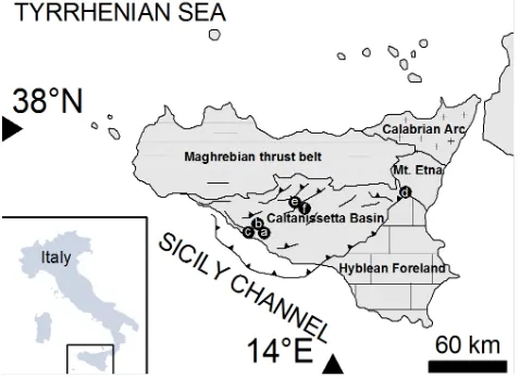
Fig. 1.Structural setting of Sicily with location of onshore mud vol-canoes. (a)Maccalube at Aragona;(b)Fuoco di Censo at Bivona;
(c)Bissana at Cattolica Eraclea;(d)Salinelle at Patern`o;(e) Maria-nopoli;(f)Santa Barbara.
of Sicily and its offshore continuation (Fig. 1): (i) the Hy-blean Foreland outcropping in southeastern Sicily; (ii) the Caltanissetta Basin, a dynamic foredeep basin from the Late Miocene to the Quaternary; and (iii) a complex chain, thrust towards the east and southeast, consisting of the Calabrian Arc and the Maghrebian thrust belt (Vallone et al., 2008 and references therein).
The first historical notices on sedimentary volcanism in Caltanissetta are reported by the abbot Ferrara (1822) and Li Volsi (1826), who documented paroxysmal eruptions in 1783, 1817, 1819, and 1823.
The local geological succession (ICS, 2004) spans from Late Miocene to Quaternary. Its bottom is represented by Tortonian (Middle-Upper Miocene) clays (Argille Brecciate II) (Ogniben, 1954). They are covered by the evaporites of the Gessoso-Solfifera Formation, deposited during the Messinian (Upper Miocene) salinity crisis in the Mediter-ranean Sea and consisting, from bottom to top, of bedded diatomites (Tripoli Formation), limestones (sometimes evap-oritic), and gypsum deposits interbedded with clay levels. The Trubi Formation, stratigraphically continuous but geo-metrically discordant, covers the Gessoso-Solfifera Forma-tion and consists of marls and marly limestones of Zanclean age (Low Pliocene). The Trubi Formation is interlayered and/or covered by the Argille Brecciate IV Formation (Early Pliocene) (Ogniben, 1954), consisting of clay deposits with olistostromic intercalations. These deposits widely outcrop in the studied area, with no soil coverage and enclose exotic elements from older formations.
3 Materials and methods
Positions of fluid emitting vents and fracture network were acquired by three differential GPS surveys, carried out on 13 August, 11 September 2008, and 26 April 2010, using a pair of Thales Magellan single frequency GPS units; position data were post-processed using the Thales Mobile Mapper soft-ware, with a final position error of 0.3 m. All the data have been analyzed in a GIS environment (Quantum GIS, release 1.0.2) and overlaid on a georeferenced raster base map at the nominal scale of 1:10 000.
The isopach map of the muddy material expelled during the paroxysmal events was generated with a kriging algo-rithm using Golden Software Surfer (release 8) from both direct measurements on the boundary of the deposit and al-titude differences (maximum error 0.2 m) measured along a transect by the use of a laser distantiometer MDL Laser Ace equipped with an electronic accelerometer for zenithal an-gles determination. The buried topography (altitude errors estimated in few tens of centimetres, thanks to the regular ground surface around vent locations and the presence of to-pographical ground control points) was subtracted from the measures prior to their elaboration.
Chemical-physical parameters (pH, Eh, electric conduc-tivity and water temperature) were measured directly in the field on 9 August 2010 by portable Orion devices. Wa-ter samples from the same vents were collected and stored for 24 h in 1 l PET bottles for decanting most of the sus-pended clay material. Water was then twice filtered, using in sequence 1.2 and 0.45 µm filters (Acrodisk), and stored in 50 cc PET bottles, stabilizing the sample for cation
anal-ysis with one drop of 0.1 N chloridric acid. Dissolved ions were analyzed using an ion chromatograph (Dionex DX120) equipped with columns for anions (AS14A) and cations (CS12A), with the exception of bicarbonates, determined by titration.
Water stable isotope ratios were determined on the filtered aliquot. The δD and δ18O compositions were determined using on-line pyrolysis system and CO2-water equilibration conventional technique respectively. Isotope ratios, reported in delta notation vs V-SMOW international standard, were measured with a CF-IRMS (Delta Plus, Thermo Bremen, Germany). Analytical precision for each measurement was better than 0.1‰ forδ18O and 1‰ forδD.
Earthquake locations in Central Sicily, located within an area defined by a rectangle with coordinates 37◦.14–37◦.74 latitude (N) and 13◦.68–14◦.72 longitude (E) and covering the period 2002–2009, have been investigated by consider-ing National Seismic Network data (available through http:// bollettinosismico.rm.ingv.it/) integrated with those collected by the local Sicilian Seismic Network (Gruppo Analisi Dati Sismici, 2011). The seismic networks, managed by the Isti-tuto Nazionale di Geofisica e Vulcanologia (INGV), consist of about 90 seismic stations distributed all over Sicily, but mainly operating in the eastern part. Epicentral distribution of the events were located using the computer program Hy-poellipse (Lahr, 1999).
4 The 11 August 2008 eruption
4.1 Description of the event and morphological evolution of the area
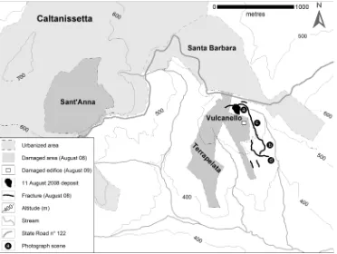
The Santa Barbara Village (Fig. 2) is located in the south-easternmost part of the city of Caltanissetta; it was origi-nally built up in the second half of the last century as a miner’s housing project. The State Road no. 122 separates the Santa Barbara Village from Contrada Terrapelata (“Ter-rapelata” means “nude ground” in Italian, evidently referring to the total absence of soil coverage and vegetation typical of sedimentary volcanism); within Contrada Terrapelata, the fluid emitting vents are located in a place called “Vulcanello” (little volcano).
Fig. 2.Topographic map of Santa Barbara area, with localization of the main features and damaged areas related to mud volcanoes activity.
Fig. 3.View of Vulcanello area two days after the 11 August 2008 paroxysmal event. The grey clay deposit is the material erupted by the paroxysm.
at several hundreds of meters of distance, were ejected from the mud volcanoes up to 20–30 m above the ground.
The paroxysmal phenomenon lasted several minutes and covered the Vulcanello area (Fig. 3) with a muddy deposit that quickly assumed a leaf shape due to a slow southward movement along a very gentle hillslope.
As revealed by the GPS survey carried out two days later (13 August, Fig. 4a), the neo-formed mud deposit occupied an area of about 12 000 m2, with the emitting vents located in its upper quarter. The deposit consisted of very wet clay with chaotic structure within which numerous lithic fragments, from a few decimetres to several centimetres in diameter,
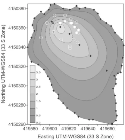
were found. As shown in the isopach map reported in Fig. 5, the deposit reached its maximum thickness of about 3.5 m around the vents, whereas at its boundary it was 0.3 m thick without any differences between the up- and down-slope por-tions. Based on the isopach map, the total volume of the emitted material was estimated about 9500 m3.
Fig. 4. Perimeter of mud volcano deposit (grey area) of the 11 August 2008 eruption with location of the emitting vents in three different periods:(a)13 August 2008(b)11 September 2008;(c)26 April 2010.
Fig. 5. Isopach map of the 11 August 2008 mud volcano deposit; black diamonds are the thickness measuring points, white void cir-cles the mud emitting vents, white stars the gas emitting vents.
maximum thickness point. In addition to the concentrated emissions, the entire vent area was characterized by diffuse degassing from the cracks.
A second survey carried out one month after the eruption (11 September 2008, Fig. 4b) evidenced significant quali-quantitative variations in fluid emissions, which have contin-ued since the paroxysm. A total of 81 vents were recognized in the field, 63 of which emitting fluid mud with bubbling gas and 18 inactive (small pools of stagnant fluid mud); the
vents were randomly distributed, with the exception of an ESE-NNW alignment of few points at the southern border of the vent area.
After the 11 August 2008 paroxysm, only one minor anomalous emission has occurred in the Vulcanello area: a network of fractures that, in the first half of August 2009, opened across an edifice (immediately cleared after the event) located about 250 m SSE of Vulcanello (see Fig. 2 for its location). During an inspection carried out on 12 August 2009, the sound of bubbling and methane concentrations up to 10% vol was recorded into that fractures, evidencing the presence of a secondary, peripheral vent field under the build-ing.
A control survey was exploited on 26 April 2010, whose results are summarized in Fig. 4c. The total number of vents was nearly the same as the 11 September 2008 survey: 74 instead of 81, 54 of which were emitting mud and gas and 20 were inactive. Two very evident structures were marked by vent positions: (i) a sub-circular ring around a main vent and (ii) a SSW-ENE alignment immediately northward from the previous feature.
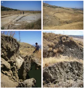
Fig. 6.Field photographs taken at different times illustrating the morphological features of the emitting vents (simplified cross-sections in graphical insets):(a)13 August 2008;(b)17 August 2008;(c)17 September 2008;(d)26 April 2010.
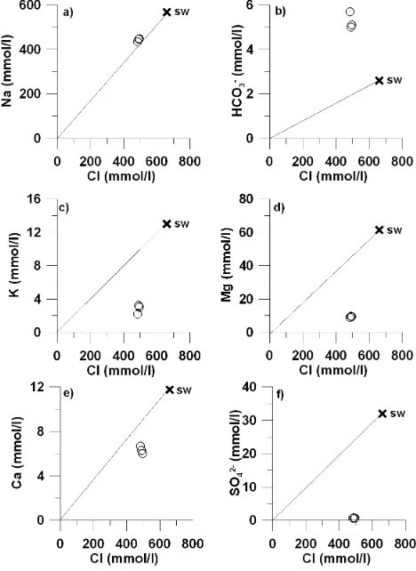
Fig. 8. Plots of major and minor constituent vs. Cl. Na(a), alka-linity(b), K(c), Mg(d), Ca(e)and SO4(f). Mixing line between freshwater and Mediterranean seawater is also reported.
tens of centimetres high, emitting mud flowing apart in well separated arms. A little less than two years after the paroxysm (Fig. 6d, 26 April 2010) all the features appeared very enlarged but smoothed in elevation, due to the inter-actions between the constructive action of the continuously upwelling mud and the rainfall-driven erosion.
The morphological features due to the 11 August 2008 eruption were not limited to the area strictly surrounding the main emission point, but extended far away as an ar-ticulated network of fractures. As reported in Fig. 2, these fractures were not limited to the immediate surroundings of the eruptive vents, and developed for more than 1 km along the fluvial valleys running toward south from Vulcanello. The horizontal and vertical displacements across the frac-tures were not related to their distance from the mud vol-canoes. As shown in Fig. 7, simple cracks with centimetric displacements (Fig. 7a) were observed together with features of higher dimensions in the immediate surroundings of the vents. At hundreds of meters of distance, entire portions of slopes (Fig. 7b) were cut by discontinuities, with both horizontal and vertical movements two orders of magnitude higher (Fig. 7c). Another phenomenon related to the eruption
Table 1. Physico-chemical parameters and concentrations of ma-jor elements in the collected waters. Water temperature is ex-pressed in◦C, EC ( = electrical conductivity) in mS cm−1, pH in pH units, Eh in mV. Concentrations are expressed in mg l−1and TDS in g l−1. Alk = total alkalinity reported as HCO3. Isotopic com-position is reported in delta per mil vs. V-SMOW. SI = saturation index: a = aragonite; c = calcite; d = dolomite; anh = anhydrite; g = gypsum..
P1 P2 P3 MSW
T◦C 26.8 26.1 29.9
pH 7.47 7.58 7.52 8.20 EC 30.2 37.3 39.4 54.4 Eh −42 25 60
Na 10 261 10 196 9924 13 007 K 120 125 87 508 Mg 227 236 220 1494 Ca 241 252 268 471 Cl 17 541 17 354 17 124 23 397 Br 41 25 44 78 SO4 61 71 68 3072 Alk 311 305 348 159 δD −7.0 −6.0 −11.0 11.0
δ18O 10.1 10.6 10.1 1.6
TDS 28.8 28.6 28.5 42.2 Na/Cl 0.91 0.91 0.90 0.86 SIa 0.13 0.24 0.49
SIc 0.28 0.39 0.64 SId 0.47 0.67 1.13 SIanh −2.59 −2.52 −2.32 SIg −2.44 −2.36 −2.20
was the brecciation of the clay deposits (Fig. 7d) ubiquitously outcropping in the southern sector of the study area, which occurred especially at the foot of the steepest slopes.
4.2 Water and stable isotopes geochemistry of the emitted fluids: a hypothesis on their origin
Major and minor dissolved constituents and isotopic compo-sitions are reported in Table 1. The collected waters have a salinity around 28 g l−1 and near-neutrality pH values. δD andδ18O values are around−8‰ and +10‰ respectively.
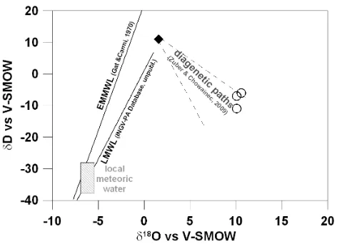
Fig. 9. Oxygen-18 vs. Deuterium plot showing Eastern Mediter-ranean Meteoric Water Line (EMMWL) of Gat and Carmi (1970), Local Meteoric Water Line and the field of local meteoric water (INGV Database, unpublished data). Water stable isotopes suggest waters are modified by diagenetic processes.
Many of these features, which are common to both fluids emitted from some onshore MVs areas (Dia et al., 1999; You et al., 2004) and pore waters associated with several subma-rine mud volcanoes (Martin et al., 1996; Fitts and Brown, 1999; Brown et al., 2001; D¨ahlmann and De Lange, 2003), are most likely the result of diagenetic processes.
The marked depletion in sulphate ions is a possible evidence of bacterial sulphate reduction, associated with degradation of organic matter and/or anaerobic oxidation of methane (Murray et al., 1978), that takes place in these wa-ters as follows:
2CH2O+SO24−⇔H2S+2HCO−3+H2O (1) CH4+SO24−⇔HS−+HCO−3+H2O (2) Increasing of dissolved inorganic carbon content also result from these reactions.
The collected waters also show an enrichment in Na con-current to depletion in K. This is likely due to the illitization of smectites (Hower et al., 1976) and/or ion-exchange reac-tions between waters and clay minerals (Martin et al., 1996). The contents of calcium and magnesium, lower than seawater (<6 mM l−1 and <10 mM l−1 respectively), sug-gest that these two elements are involved in intense water-sediment exchanges at high temperature, as already observed in waters emitted from Taiwanese mud volcanoes (You et al., 2004) and/or in the precipitation of secondary Ca- and Mg-bearing carbonates, mostly enhanced by increased dissolved inorganic carbon contents.
Mineral saturation indices (SI), calculated by the PHREEQC computer program (Parkhurst and Appelo, 1999), indicate that the waters are saturated or slightly over-saturated with respect to dolomite (SId 0.47÷1.13), calcite
Fig. 10.Ternary Na-K-Mg diagram (after Giggenbach, 1988). Col-lected waters fall with the “partial equilibrium” field at temperatures between 80 and 130◦C (concentrations in mg l◦).
(SIc 0.28÷0.92), aragonite (SIa 0.13÷0.78) and magne-site (SIm 0.10÷0.6), while these are strongly undersaturated with respect to gypsum (SIg −2.4÷ −2.2) and anhydrite (SIanh−2.6÷ −2.3).
From an isotopic point of view, all the collected waters show unusual positive δ18O values. In the δD/δ18O dia-gram (Fig. 9), they fall on the right of both the reference line for Mediterranean rainwater (EMMWL) (Gat and Carmi, 1970) and the local meteoric waters (INGV-Palermo internal database, unpublished data), roughly following the so-called “diagenetic paths” (Zuber and Chowaniec, 2009).
As already suggested for the MVs associated with other modern accretionary prisms (Brown et al., 2001; D¨ahlmann and De Lange, 2003), pore water freshening and positive oxygen-18 values could be related to low-grade mineral transformations (smectite dewatering, smectite/illite, opal dehydration) and/or to gas hydrates destabilization. The lat-ter process can be ruled out, since walat-ter released during gas hydrate formation is expected to be enriched in heavy iso-topes with respect to the pristine isotopic composition of wa-ter from which gas hydrate were originated.
On the contrary, dewatering of carbonate-free oceanic clay sediments should produce water depleted inδD and enriched inδ18O values (Magaritz and Gat, 1981).
Fig. 11. Epicentral location of all the seismic events recorded in Central Sicily during the 2002–2009 period. Red circles are the August 2008 events, yellow circles are the August 2009 events, and blue circles all the others. The black star is the Santa Barbara area.
Mediterranean submarine MVs, assuming that water is re-leased from smectite/illite transformation at temperatures of 150◦C (D¨ahlmann and De Lange, 2003).
As previously argued, the chemical and isotope composi-tion of the waters associated with S. Barbara MVs suggest that freshening of initial seawater is probably due to inter-layer water released from clay minerals lattice during diage-nesis.
These diagenetic reactions, including mineralogical trans-formations, geochemical and biochemical processes, occur between water and sediments at different steps: early stages of compaction, burial processes, tectonic deformation, or during the upwelling of deeper fluids flowing through the overlying sedimentary sequence.
In order to constrain the depth of the source of S. Barbara MVs waters, some theoretical ionic solutes geothermome-ters, based on temperatudependent mineral exchange re-actions, have been applied.
The triangular Na-K-Mg plot (Fig. 10), which combines both the Na/K and the K/Mg geothermometers in a unique di-agram (Giggenbach, 1988), highlights that these waters have partially reached their thermodynamic equilibrium with min-erals, pointing to an equilibrium temperature around 110◦C (range 88–128◦C).
Such an estimation fits very well with the temperature range (60–80◦C) during which the smectite starts its trans-formation into illite, thus leading to the releasing of inter-layer waters (Colten-Bradley, 1987).
In-situ heat flow measurements in the neighboring Ionian oceanic basin (Della Vedova and Pellis, 1989) and thermal gradient assessed by Mattavelli and Novelli (1990) for oil generation in the southern Sicily foredeep, suggest that the local thermal gradient is about 20±2◦C km−1. Based on the geothermometer estimation (Teq=108±20◦C), the source of fluids could be located starting at a depth of 3000 m. This depth is compatible both with the total thickness of clay
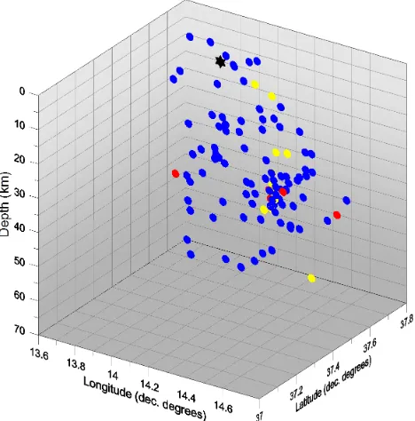
sed-Fig. 12. Hypocentral location of all the seismic events recorded in Central Sicily during the 2002–2009 period. Red circles are the August 2008 events, yellow circles the August 2009 events, blue circles all the others. The black star is the Santa Barbara area.
iments within the Sicilian accrectionary prism (6000 m, as reported by Monaco and Tortorici, 1996) and the presence of fluids originated from dewatering of sediments trapped in the upper decollements of the prism (Larroque et al., 1996).
4.3 Relationship with seismic activity
Central Sicily can be considered an area of low to very low seismic activity, with infrequent and low-intensity seismicity if compared to the eastern sector. Large earthquakes have not been documented for the past centuries in this area (Boschi et al., 1997).
During the observational period (2002–2009), a total of 110 seismic events were recorded; their magnitude mostly ranged between 1 and 2.5, with a highest value outlier of 4.7. An anomaly such as the 4.7 highest value is known as an “outlier”. Epicentral distribution of the events is shown in Fig. 11. The 3-D graph of Fig. 12 shows a seismicity gener-ally extended to about 60 km depth but mainly concentrated from 20 to 40 km; very few events are located in the shal-lowest region 0–5 km. It can be assumed that the data are generally homogeneously compiled over the whole area and the map is claimed to be representative of the space distribu-tion of activity in the study region.
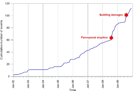
Fig. 13. Cumulative time distribution of the earthquakes recorded in the study area during the observational period; red stars indicate the main paroxysmal events that occurred in 2008 and 2009.
dispersed within a sub-regional seismogenetic volume, with no evidence of tectonic structures passing through or in the vicinity of Santa Barbara area.
Figure 13 shows the cumulative time distribution of the earthquakes recorded during the considered period. As can be seen in the monthly cumulative number of events, the curve exhibits a certain uniformity with constant rate of seis-micity with two steps detected in August 2008 and in August 2009. In August 2008, the dataset consisted of recordings of 5 earthquakes with magnitudes ranging from 1.7 to 2.4 in the radius of 10–55 km from the site. In August 2009, 12 earth-quakes with magnitudes ranging from 1.5 to 2.7 in the radius of 20–50 km from the site were recorded. In both cases, the observed steps are temporally close to the two most signifi-cant phenomena occurring in the studied area: the MV parox-ysmal eruption in August 2008 and the network of fractures opened in August 2009 at about 250 m SSE of Vulcanello. More in detail, the August 2008 paroxysm was isochronous with respect to the onset of the anomalous seismic period, whereas the August 2009 event took place after seismicity had already increased. All the seismic events recorded in the two periods were too deep or too far with respect to Santa Barbara MV area for directly relating them to the paroxysm in a time-consistent cause-effect relationship.
The lack of direct spatial relationships and the timing of seismic activity lead to exclude a direct seismically triggered MV paroxysmal activity but, at the same time and as bet-ter discussed in the next chapbet-ter, the temporal correlation between MV anomalous activity and earthquakes suggests that both phenomena could be parts of a much larger class of crustal unstable processes at work in the area, i.e. “crustal transients” following the definition of Bernard (2001).
ids or, at least, for their last long-time standing (sufficient to ensure the chemical equilibrium status of the water-rock sys-tem) before their emissions on the ground level. According to the classification discussed by Kopf (2002), geochemical and geological data suggest that Santa Barbara MV activ-ity is mainly originated by buoyancy of clay sediments, rich in organic matter, ascending toward the Earth’s surface due to a density inversion determined by a considerable amount of seawater trapped in the intergranular spaces at the time of their sedimentation. Moreover, authigenic water derived from early diagenetic dehydration reactions may play an ad-ditional role in fluid overpressuring.
As previously discussed, Santa Barbara MVs have been characterized by prolonged periods of mild activity, inter-rupted by paroxysmal events. This behaviour accounts for a sealed fluid reservoir, progressively overpressured, due to the continuous gas production, since its internal pressure over-comes the lithostatic confining charge. Migration of fluids from the source rock to the near-surface last standing may be favoured by the presence of tectono-stratigraphic discontinu-ities associated to the regional overthrust limit that separates the Caltanissetta Basin from the northernmost chain (Vallone et al., 2008 and references therein).
Taking into account the very impulsive nature of the 2008 paroxysm, as reported by the eyewitnesses, it was probably due to a strong gas overpressure that generated a gas blast.
The onset a few hours before the paroxysm of a leakage fracture network in the immediate surroundings of the MVs signaled the final step of the pressure overloading, whereas the building damages occurring some kilometers away and all the other fractures that cut the slopes southward from the main emission point were probably due to the ground shak-ing generated by the near-surface shock wave produced by the gas blast. The absence of any signal of this phenomenon recorded by the regional seismic network is likely due to its very shallow location, within a rock volume made of palaeo-landslides poorly coupled with the underlying sediments.
the emissions were dominated by gaseous phases, whereas mud upwelling resumed its background flow a month after the paroxysm.
MV paroxysms and seismic activity are not in a simple cause-effect relationship.
The direct action of a seismic event as a trigger of the paroxysm can be excluded, because timing and distribution of seismic events are not compatible with the activation of a tectonic discontinuity passing through or in the vicinity of Santa Barbara. On the other hand, taking into account the anomalously high seismic activity recorded both around the 2008 main event and its secondary tail in August 2009, the intensification of a sub-regional stress field responsible for the increase in seismicity, played a seemingly significant role in sparking the impulsive fluid emissions. Moreover, it is no-ticeable that the maximum number and dimension of emit-ting vents (September 2008) were reached at the end of the first of the two periods of increased seismic activity, while during the second one (August 2009), the minor paroxysm (fractures and fluid emissions under the edifice 250 SSE from Vulcanello) took place.
Both occurrences support the conviction that a stress field, acting at a spatial scale at least one order of magnitude greater than the study area, could represent the common source for both the seismic and MV activities, even if nei-ther of the two is the cause nor the effect of the onei-ther one. As already mentioned, the two phenomena, seismicity and MV activities, are “crustal transients”, i.e. instability phenomena characterized by independent source mechanisms, different space and time constrains, and different activation energies needed to generate the impulsive event that will bring the two systems back to a new metastable equilibrium, but with a common trigger: changes in the stress field acting in the rock volume where both phenomena take place. Under this light, the time lags among the MV paroxysms and the earth-quakes are only the symptoms that they are moving from different grades of instability, under different change rates of their state, toward different thresholds over which abrupt changes will take place. In other words and following this interpretation, seismic activity and MV paroxysms are both the symptoms of changes in the regional stress field. Their concurrence in the future is likely, if not probable, but their reciprocal timing, i.e. the possibility that MV paroxysms will be the precursors of earthquakes, or vice-versa, is a pseudo-random variable controlled by the extent to which the chang-ing stress field will influence the instability of the two com-pletely separated systems.
6 Conclusions
The geomorphological, geochemical, and seismological in-vestigations carried out on the 11 August 2008 paroxysmal event at Santa Barbara MVs, with the associated minor event
of August 2009, gave the opportunity to framework the stud-ied phenomena in a wider scale geodynamic context.
In particular, geochemical constrains located the source, or the last standing, of the fluids originating the MV eruptions at about 3 km depth. Geomorphological surveys allowed us to reconstruct the main steps of the paroxysmal activity, identi-fying in ground deformations accompanying the last phase of the gas pressure overload and in the consequent shock wave and gas blast, the main causes of all the damages suf-fered by anthropic structures located in the surroundings of the MV active area. Finally, the close time relationships ob-served between anomalous increments of seismic activity in the Central Sicily area and the August 2008 and August 2009 events account for a common possible trigger for both the phenomena, even if the very different initial conditions and characteristics of the two processes, i.e. seismogenesis and gas overloading, led to exceeding their critical thresholds at different times. The common trigger can be identified in the evolution of the stress field due to wide-scale geodynamical processes acting in the Central Sicily area.
This interpretation is coherent with the theory of “crustal transients” proposed by Bernard (2001), under whose light most of the crustal phenomena seem to find the way to be correctly understood.
Acknowledgements. We wish to thank L. Brusca, S. Francofonte, and M. Longo (Palermo Branch of the Italian National Institute of Geophysics and Volcanology, INGV) and M. Costa, I. Madonia, and S. Meraviglia (University of Palermo) for their precious help during field surveys and analytical activities. We are also grateful to Lucia Capra (UNAM) and another anonymous reviewer for their suggestions.
Edited by: J. Marti
Reviewed by: L. Capra and another anonymous referee
References
Abikh, G. V.: New Islands on the Caspian Sea and the Cognition of Mud Volcanoes of the Caspian Region, Mem. Acad. Sci. Pe-terbourg, Ser. VIII, 6(5), (Translated from the German, Tr. Inst. Geol. Azer., Fil. Akad. Nauk SSSR, 12, 1548 pp., 1939), 1863. Aliyev, A. A.: Mud volcanism of the South-Caspian oil-gas basin,
in South-Caspian Basin: Geology, Geophysics, Oil and Gas Con-tent, 186–212, Nafta, Baku, Azerbaijan, 2004.
Baciu, C. and Etiope, G.: Mud volcanoes and seismicity in Ro-mania, in: Mud Volcanoes, Geodynamics and Seismicity, NATO Sci. Ser. Earth Environ., 51, edited by: Martinelli, G. and Panahi, B., 77–88, Springer, New York, 2005.
Beresnev, I. A. and Johnson, P. A.: Elastic-wave simulation of oil production: A review of methods and results, Geophysics, 59, 1000–1017, 1994.
Bernard, P.: From the search of “precursors” to the research on “crustal transients”, Tectonophysics, 338, 225–232, 2001. Boschi, E., Guidoboni, E., Ferrari, G., Gasperini, P., and Valensise,
Jpn., 103, 781–793, 1997.
Colten-Bradley, V. A.: Role of pressure in smectite dehydratation-effects on geopressure and smectite/illite transformation, AAPG Bulletin, 71, 1414–1427, 1987.
D¨ahlmann, A. and De Lange, G. J.: Fluid-sediment interactions at eastern Mediterranean mud volcanoes: a stable isotope study from ODP leg 160, Earth Planet. Sc. Lett., 212, 377–391, 2003. Davies, R., Manga, M., Tingay, M., Lusianga, S., and Swarbrick,
R.: Sawolo et al. (2009) the Lusi mud volcano controversy: Was it caused by drilling?, Mar. Petrol. Geol., 27, 1651–1657, 2010. Delisle, G., von Rad, U., Andruleit, H., von Daniels, C. H., Tabrez,
A. R., and Inam, A.: Active mud volcanoes on- and offshore eastern Makran, Pakistan, Int., J. Earth Sci., 91, 93–110, 2002. Della Vedova, B. and Pellis, G.: New heat flow density
measure-ments in the Ionian Sea, 80 Conv. Naz. GNGTS, CNR, Rome, 1133–1146, 1989.
Dewey, J. F., Helman, M. L., Turco, E., Hutton, D. H. W., and Knott, S. D.: Kinematics of the western Mediterranean, Alpine Tecton-ics, Geological Society Special Publication, 45, 265–283, 1989. Dia, A. N., Castrec-Rouelle, M., Boulege, J., and Comeau, P.:
Trinidad mud volcanoes where do the expelled fluids come from?, Geochim. Cosmochim. Acta, 63, 1023–1038, 1999. Dimitrov, L. I.: Mud volcanoes—the most important pathway for
degassing deeply buried sediments, Earth-Sci. Rev., 59, 49–76, 2002.
Etiope, G., Caracausi, A., Favara, R., Italiano, F., and Baciu, C.: Methane emission from the mud volcanoes of Sicily (Italy), Geophys. Res. Lett., 29(8), 1215, doi:10.1029/2001GL014340, 2002.
Ferrara, F.: Guida dei viaggiatori agli oggetti pi`u interessanti a ved-ersi in Sicilia, Palermo, Tip. Abbate, 1836 Monografia – Testo a stampa (IT\ICCU\NAP\0159455) 6, 1822.
Fitts, T. G. and Brown, K. M.: Stress induced smectite dehydration ramifications for patterns of freshening fluids expulsion in the N. Barbados accretionary wedge, Earth Planet. Sc. Lett., 172, 179– 197, 1999.
Gat, J. R. and Carmi, H.: Evolution of the isotopic composition of atmospheric waters in the Mediterranean Sea area, J. Geophys. Res., 75, 3039–3040, 1970.
Giggenbach, W. F.: Geothermal solute equilibria. Derivation of Na-K-Mg-Ca geoindicators, Geoch. Cosmoch. Acta, 52, 2749–2765, 1988.
Gomberg, J. and Davis, S.: Stress/strain changes and triggered
seis-Hower, J., Eslinger, E. V., seis-Hower, M. E., and Perry, E. A.: Mecha-nism of burial metamorphism of argillaceous sediments: 1. Min-eralogical and chemical evidence, Geol. Soc. Am. Bull., 87, 725– 737, 1976.
ICS International Commission on Stratigraphy: International Strati-graphic Chart. Cambridge University Press, 2004.
Kopf, A. J.: Significance of mud volcanism, Rev. Geophys., 40, B1–B49, 2002.
Lahr, J. C.: HYPOELLIPSE: A computer program for determining local earthquake hypocentral parameters, magnitude, and first motion pattern, (Y2K compliant version) U.S. Geological Sur-vey Open-File Report 99–23, 112 pp., 1999.
Larroque, C., Guilhaumou, N., Stephan, J. F., and Roure, F.: Ad-vection of fluids at the front of the Sicilian Neogene subduction complex, Tectonophysics, 254, 41–55, 1996.
Li Volsi, S.: Memoria sul vulcano aereo (ossia gasoso) (I) di Ter-rapilata in Caltanissetta dell’abate Salvatore Li Volsi, dedicata a S. E. sig. March. Delle Favare Ministro Segretario di Stato, Lu-ogotenente Generale in Sicilia. Giornale di Scienze, Lettere ed Arti per la Sicilia, Tomo XIII, Anno IV, Gennajo, Febbrajo e Marzo, Palermo Presso Lorenzo Dato, 1826.
Lickorish, W. H., Grasso, M., Butler, R. W. H., Argnani, A., and Maniscalco, R.: Structural styles and regional tectonic setting of the “Gela Nappe” and frontal part of the Maghrebian thrust belt in Sicily, Tectonics, 18, 655–668, 1999.
Linde, A. T. and Sacks, I. S.: Triggering of volcanic eruptions, Na-ture, 395, 888–890, 1998.
Magaritz, M. and Gat, J. R.: Review of the natural abundance of hydrogen and oxygen isotopes, in: Stable Isotopes Hydrology – Deuterium and Oxygen-18 in the water cycle, edited by: Gat, J. R. and Gonfiantini, R., Technical reports series 210, International Atomic energy Agency, Vienna, 85–102, 1981.
Martin, J. B., Kastner, M., Henry, P., Le Pichon, X., and Lalle-mant, S.: Chemical and isotopic evidence for sources of fluids in a mud volcano field seaward of the Barbados accretionary wedge, J. Geophys. Res., 101, 20325–20345, 1996.
Martinelli, G. and Dadomo, A.: Volcano monitoring and seismic events, in Mud Volcanoes, Geodynamics and Seismicity, NATO Sci. Ser. Earth Environ., 51, edited by: Martinelli, G. and Panahi, B., Springer, New York, 211–220, 2005.
Mazurenko, L. L., Soloviev, V. A., Gardner, J. M., and Ivanov, M. K.: Gas hydrates in the Ginsburg and Yuma mud volcano sedi-ments (Moroccan Margin): results of chemical and isotopic stud-ies of pore water, Mar. Geol., 195, 201–210, 2003.
Mazzini, A., Nermoen, A., Krotkiewski, M., Podladchikov, Y., Planke, S., and Svensen, H.: Strike-slip faulting as a trigger mechanism for overpressure release trough piercement struc-tures. Implications for the Lusi mud volcano, Indonesia, Mar. Petrol. Geol, 26, 1751–1765, 2009.
Mellors, L., Kilb, D., Aliyev, A., Gasanov, A., and Ye-tirmishli, G.: Correlations between earthquakes and large mud volcano eruptions, J. Geophys. Res., 112, B04304, doi:10.1029/2006JB004489, 2007.
Monaco, C. and Tortorici, L.: Clay diapirs in Neogene–Quaternary sediments of central Sicily: evidence for accretionary processes, J. Struct. Geol., 18, 1265–1269, 1996.
Murray, J. W., Grundmanis, V., and Smethie, W. M. Jr.: Intersti-tial water chemistry in the sediments of Saanich inlet, Geochim. Cosmochim. Acta, 42, 1011–1026, 1978.
Ogniben, L.: Le argille brecciate Siciliane, Mem. Ist. Geol. Mineral. Univ. Padova, 18, 1–92, 1954.
Parkhurst, D. L. and Appelo, C. A. J.: User’s guide to PHREEQC A computer program for speciation, batch-reaction, one-dimensional transport, and inverse geochemical calcula-tions: U.S. Geological Survey Water-Resources Investigations Report 99-4259, 312 pp., 1999.
Roeloffs, E., Sneed, M., Galloway, D. L., Sorey, M. L., Farrar, C. D., Howle, J.-F., and Hughes, J.: Water-level changes induced by local and distant earthquakes at Long Valley caldera, California, J. Volcanol. Geotherm. Res., 127, 269–303, 2003.
Savini, A., Malinverno, E., Etiope, G., Tessarolo, C., and Corselli, C: Shallow seep-related seafloor features along the Malta plateau (Sicily channel–Mediterranean Sea): Morphologies and geo-environmental control of their distribution, Mar. Petrol. Geol., 26, 1831–1848, 2009.
Sawolo, N., Sutriono, E., Istadi, B., and Darmoyo, A. B.: The LUSI mud volcano controversy: was it caused by drilling?, Mar. Petrol. Geol., 26, 1766–1784, 2009.
Serpelloni, E., Vannucci, G., Pondrelli, S., Argnani, A., Casula, G., Anzidei, M., Baldi, P., and Gasperini, I.: Kinematics of the West-ern Africa–Eurasia plate boundary from focal mechanisms and GPS data, Geophys. J. Int., 169, 1180–1200, 2007.
Vallone, P., Giammarinaro, M. S., Crosetto, M., Agudo, M., and Bi-escas, E.: Ground motion phenomena in Caltanissetta (Italy) in-vestigated by InSAR and geological data integration, Eng. Geol., 98, 144–155, 2008.
You, C. F., Gieskes, J. M., Lee, T., Yui, T. F., and Chen, H. W.: Geochemistry of mud volcano fluids in the Taiwan accretionary prism, Appl. Geochem., 19, 695–707, 2004.