Date:
2006-03-15
Reference number of this document:
OGC® 06-042
Version:
1.3.0
Category
: OpenGIS
®Implementation Specification
Editor
:
Jeff de la Beaujardiere
OpenGIS® Web Map Server Implementation Specification
Copyright © 2006 Open Geospatial Consortium, Inc. All Rights Reserved. To obtain additional rights of use, visit http://www.opengeospatial.org/legal/.
Document type:
OpenGIS
®Implementation Specification
Document subtype:
Not Applicable
Document stage:
Final
License Agreement
Permission is hereby granted by the Open Geospatial Consortium, ("Licensor"), free of charge and subject to the terms set forth below, to any person obtaining a copy of this Intellectual Property and any associated documentation, to deal in the Intellectual Property without restriction (except as set forth below), including without limitation the rights to implement, use, copy, modify, merge, publish, distribute, and/or sublicense copies of the Intellectual Property, and to permit persons to whom the Intellectual Property is furnished to do so, provided that all copyright notices on the intellectual property are retained intact and that each person to whom the Intellectual Property is furnished agrees to the terms of this Agreement.
If you modify the Intellectual Property, all copies of the modified Intellectual Property must include, in addition to the above copyright notice, a notice that the Intellectual Property includes modifications that have not been approved or adopted by LICENSOR.
THIS LICENSE IS A COPYRIGHT LICENSE ONLY, AND DOES NOT CONVEY ANY RIGHTS UNDER ANY PATENTS THAT MAY BE IN FORCE ANYWHERE IN THE WORLD.
THE INTELLECTUAL PROPERTY IS PROVIDED "AS IS", WITHOUT WARRANTY OF ANY KIND, EXPRESS OR IMPLIED, INCLUDING BUT NOT LIMITED TO THE WARRANTIES OF MERCHANTABILITY, FITNESS FOR A PARTICULAR PURPOSE, AND NONINFRINGEMENT OF THIRD PARTY RIGHTS. THE COPYRIGHT HOLDER OR HOLDERS INCLUDED IN THIS NOTICE DO NOT WARRANT THAT THE FUNCTIONS CONTAINED IN THE INTELLECTUAL PROPERTY WILL MEET YOUR REQUIREMENTS OR THAT THE OPERATION OF THE INTELLECTUAL PROPERTY WILL BE UNINTERRUPTED OR ERROR FREE. ANY USE OF THE INTELLECTUAL PROPERTY SHALL BE MADE ENTIRELY AT THE USER’S OWN RISK. IN NO EVENT SHALL THE COPYRIGHT HOLDER OR ANY CONTRIBUTOR OF INTELLECTUAL PROPERTY RIGHTS TO THE INTELLECTUAL PROPERTY BE LIABLE FOR ANY CLAIM, OR ANY DIRECT, SPECIAL, INDIRECT OR CONSEQUENTIAL DAMAGES, OR ANY DAMAGES WHATSOEVER RESULTING FROM ANY ALLEGED INFRINGEMENT OR ANY LOSS OF USE, DATA OR PROFITS, WHETHER IN AN ACTION OF CONTRACT, NEGLIGENCE OR UNDER ANY OTHER LEGAL THEORY, ARISING OUT OF OR IN CONNECTION WITH THE IMPLEMENTATION, USE, COMMERCIALIZATION OR PERFORMANCE OF THIS INTELLECTUAL PROPERTY.
This license is effective until terminated. You may terminate it at any time by destroying the Intellectual Property together with all copies in any form. The license will also terminate if you fail to comply with any term or condition of this Agreement. Except as provided in the following sentence, no such termination of this license shall require the termination of any third party end-user sublicense to the Intellectual Property which is in force as of the date of notice of such termination. In addition, should the Intellectual Property, or the operation of the Intellectual Property, infringe, or in LICENSOR’s sole opinion be likely to infringe, any patent, copyright, trademark or other right of a third party, you agree that LICENSOR, in its sole discretion, may terminate this license without any compensation or liability to you, your licensees or any other party. You agree upon termination of any kind to destroy or cause to be destroyed the Intellectual Property together with all copies in any form, whether held by you or by any third party.
Except as contained in this notice, the name of LICENSOR or of any other holder of a copyright in all or part of the Intellectual Property shall not be used in advertising or otherwise to promote the sale, use or other dealings in this Intellectual Property without prior written authorization of LICENSOR or such copyright holder. LICENSOR is and shall at all times be the sole entity that may authorize you or any third party to use certification marks, trademarks or other special designations to indicate compliance with any LICENSOR standards or specifications.
This Agreement is governed by the laws of the Commonwealth of Massachusetts. The application to this Agreement of the United Nations Convention on Contracts for the International Sale of Goods is hereby expressly excluded. In the event any provision of this Agreement shall be deemed unenforceable, void or invalid, such provision shall be modified so as to make it valid and enforceable, and as so modified the entire Agreement shall remain in full force and effect. No decision, action or inaction by LICENSOR shall be construed to be a waiver of any rights or remedies available to it.
Contents
PageForeword ... iv
Introduction... v
1 Scope ...6
2 Conformance ...6
2.1 Conformance classes and requirements ...6
2.2 Basic WMS ...6
2.3 Queryable WMS ...6
3 Normative references...6
4 Terms and definitions ...7
5 Abbreviated terms ...8
6 Basic service elements ...9
6.1 Introduction...9
6.2 Version numbering and negotiation...10
6.3 General HTTP request rules ...11
6.4 General HTTP response rules ...13
6.5 Numeric and Boolean values ...13
6.6 Output formats...14
6.7 Coordinate systems ...14
6.8 Request parameter rules ...19
6.9 Common request parameters ...19
6.10 Service result ...20
6.11 Service exceptions ...20
7 Web Map Service operations ...21
7.1 Introduction...21
7.2 GetCapabilities (mandatory) ...21
7.3 GetMap (mandatory)...32
7.4 GetFeatureInfo (optional)...38
Annex A (normative) Conformance tests ...41
Annex B (normative) CRS Definitions ...44
Annex C (normative) Handling multi-dimensional data...51
Annex D (normative) Web Map Service profile of ISO 8601 ...57
Annex E (normative) XML Schemas ...59
Annex F (normative) UML model...72
Annex G (informative) Web Mapping Examples ...77
Annex H (informative) XML examples...80
Foreword
Attention is drawn to the possibility that some of the elements of this document may be the subject of patent rights. OGC shall not be held responsible for identifying any or all such patent rights.
Introduction
A Web Map Service (WMS) produces maps of spatially referenced data dynamically from geographic information. This International Standard defines a “map” to be a portrayal of geographic information as a digital image file suitable for display on a computer screen. A map is not the data itself. WMS-produced maps are generally rendered in a pictorial format such as PNG, GIF or JPEG, or occasionally as vector-based graphical elements in Scalable Vector Graphics (SVG) or Web Computer Graphics Metafile (WebCGM) formats.
This International Standard defines three operations: one returns service-level metadata; another returns a map whose geographic and dimensional parameters are well-defined; and an optional third operation returns information about particular features shown on a map. Web Map Service operations can be invoked using a standard web browser by submitting requests in the form of Uniform Resource Locators (URLs). The content of such URLs depends on which operation is requested. In particular, when requesting a map the URL indicates what information is to be shown on the map, what portion of the Earth is to be mapped, the desired coordinate reference system, and the output image width and height. When two or more maps are produced with the same geographic parameters and output size, the results can be accurately overlaid to produce a composite map. The use of image formats that support transparent backgrounds (e.g. GIF or PNG) allows underlying maps to be visible. Furthermore, individual maps can be requested from different servers. The Web Map Service thus enables the creation of a network of distributed map servers from which clients can build customized maps. Illustrative examples of map request URLs and their resulting maps are shown in Annex G.
This International Standard applies to a Web Map Service instance that publishes its ability to produce maps rather than its ability to access specific data holdings. A basic WMS classifies its geographic information holdings into “Layers” and offers a finite number of predefined “Styles” in which to display those layers. This International Standard supports only named Layers and Styles, and does not include a mechanism for user-defined symbolization of feature data.
NOTE The Open Geospatial Consortium (OGC) Styled Layer Descriptor (SLD) specification [6] defines a mechanism for
Geographic information — Web map server interface
1 Scope
This International Standard specifies the behaviour of a service that produces spatially referenced maps dynamically from geographic information. It specifies operations to retrieve a description of the maps offered by a server to retrieve a map, and to query a server about features displayed on a map. This International Standard is applicable to pictorial renderings of maps in a graphical format; it is not applicable to retrieval of actual feature data or coverage data values.
2 Conformance
2.1 Conformance classes and requirements
This International Standard defines two conformance classes, one for a basic WMS, and the other for a queryable WMS. Each has two subclasses, one for clients and the other for servers.
2.2 Basic WMS
A basic WMS shall support the basic service elements (see Clause 6), the GetCapabilities operation (see 7.2), and the GetMap operation (see 7.3). To conform to this International Standard, a basic WMS shall satisfy the requirements of A.1 of the Abstract Test Suite in Annex A.
2.3 Queryable WMS
A queryable WMS shall satisfy all the requirements for a basic WMS, and shall also support the GetFeatureInfo operation (see 7.4). To conform to this International Standard, a queryable WMS shall satisfy all requirements of the Abstract Test Suite in Annex A.
3 Normative
references
The following referenced documents are indispensable for the application of this document. For dated references, only the edition cited applies. For undated references, the latest edition of the referenced document (including any amendments) applies.
ISO 8601:2004, Data elements and interchange formats — Information interchange — Representation of dates and times
ISO 19111, Geographic information — Spatial referencing by coordinates ISO 19115:2003, Geographic information — Metadata
IETF RFC 2045 (November 1996), Multipurpose Internet Mail Extensions (MIME) Part One: Format of Internet Message Bodies, Freed, N. and Borenstein, N., eds., available at <http://www.ietf.org/rfc/rfc2045.txt>
IETF RFC 2396 (August 1998), Uniform Resource Identifiers (URI): Generic Syntax, Berners-Lee, T., Fielding, N., and Masinter, L., eds., available at <http://www.ietf.org/rfc/rfc2396.txt>
IETF RFC 2616 (June 1999), Hypertext Transfer Protocol – HTTP/1.1, Gettys, J., Mogul, J., Frystyk, H., Masinter, L., Leach, P., and Berners-Lee, T., eds., available at <http://www.ietf.org/rfc/rfc2616.txt>
UCUM, Unified Code for Units of Measure, Schadow, G. and McDonald, C.J. (eds.), version 1.5 <http://aurora.regenstrief.org/UCUM/ucum.html>
XML 1.0, Extensible Markup Language (XML) 1.0, World Wide Web Consortium Recommendation, Bray, T., Paoli, J., Sperberg-McQueen, C.M., and Maler, E., eds., available at <http://www.w3.org/TR/>
XML Schema, XML Schema Part 1: Structures, World Wide Web Consortium Recommendation, Thompson, H.S., Beech, D., Maloney, M., and Mendelsohn, N., eds., available at <http://www.w3.org/TR/>
4 Terms and definitions
For the purposes of this document, the following terms and definitions apply.
4.1 client
software component that can invoke an operation from a server 4.2
coordinate reference system
coordinate system that is related to the real world by a datum [ISO 19111]
4.3
coordinate system
set of mathematical rules for specifying how coordinates are to be assigned to points [ISO 19111]
4.4
geographic information
information concerning phenomena implicitly or explicitly associated with a location relative to the Earth [ISO 19101]
4.5 interface
named set of operations that characterize the behaviour of an entity [ISO 19119]
4.6 layer
4.7 map
portrayal of geographic information as a digital image file suitable for display on a computer screen
4.8 operation
specification of a transformation or query that an object may be called to execute [ISO 19119]
4.9 portrayal
presentation of information to humans [ISO 19117]
4.10 request
invocation of an operation by a client 4.11
response
result of an operation returned from a server to a client 4.12
server
a particular instance of a service
4.13 service
distinct part of the functionality that is provided by an entity through interfaces
[ISO 14252]
4.14
service metadata
metadata describing the operations and geographic information available at a server
5 Abbreviated
terms
CDATA XML Character Data
CRS Coordinate Reference System
CS Coordinate System
DCP Distributed Computing Platform DTD Document Type Definition
GIS Geographic Information System HTTP Hypertext Transfer Protocol
IANA Internet Assigned Numbers Authority IERS International Earth Rotation Service IETF Internet Engineering Task Force
ITRF International Terrestrial Reference Frame ITRS IERS Terrestrial Reference System JPEG Joint Photographic Experts Group MIME Multipurpose Internet Mail Extensions NAD North American Datum
OGC Open GIS Consortium PNG Portable Network Graphics RFC Request for Comments SVG Scalable Vector Graphics
UCUM Unified Code for Units of Measure URL Uniform Resource Locator
WebCGM Web Computer Graphics Metafile WCS Web Coverage Service
WFS Web Feature Service WGS World Geodetic System
WMS Web Map Service
XML Extensible Markup Language
6 Basic service elements
6.1 Introduction
6.2 Version numbering and negotiation
6.2.1 Version number form and value
The Web Map Service (WMS) defines a protocol version number. The version number applies to the XML schema and the request encodings defined in this International Standard. The version number contains three non-negative integers, separated by decimal points, in the form “x.y.z”. The numbers “y” and “z” shall not exceed 99.
Implementations of this International Standard shall use the value “1.3.0” as the protocol version number.
6.2.2 Version number changes
The protocol version number shall be changed with each revision of this International Standard. The number shall increase monotonically and shall comprise no more than three integers separated by decimal points, with the first integer being the most significant. There may be gaps in the numerical sequence. Some numbers may denote draft versions. Servers and their clients need not support all defined versions, but shall obey the negotiation rules below.
6.2.3 Appearance in requests and in service metadata
The version number shall appear in at least two places: in the service metadata and in the parameter list of client requests to a server. The version number used in a client’s request of a particular server shall be equal to a version number which that server has declared it supports (except during negotiation, as described below). A server may support several versions, whose values clients may discover according to the negotiation rules.
6.2.4 Version number negotiation
A WMS client may negotiate with a server to determine a mutually agreeable protocol version. Negotiation is performed using the GetCapabilities operation (described in 7.2) according to the following rules.
All service metadata shall include a protocol version number and shall comply with the XML DTD or Schema defined for that version. In response to a GetCapabilities request (for which the VERSION parameter is optional) that does not specify a version number, the server shall respond with the highest version it supports. In response to a GetCapabilities request containing a version number that the server implements, the server shall send that version. If the server does not support the requested version, the server shall respond with output that conforms to a version it does support, as determined by the following rules:
⎯ If a version unknown to the server and higher than the lowest supported version is requested, the server shall send the highest version it supports that is less than the requested version.
⎯ If a version lower than any of those known to the server is requested, then the server shall send the lowest version it supports.
⎯ If the client does not support the version sent by the server, it may either cease communicating with the server or send a new request with a different version number that the client does support.
The process may be repeated until a mutually understood version is reached, or until the client determines that it will not or cannot communicate with that particular server.
EXAMPLE 1 Server understands versions 1, 2, 4, 5 and 8. Client understands versions 1, 3, 4, 6, and 7. Client requests
EXAMPLE 2 Server understands versions 4, 5 and 8. Client understands version 3. Client requests version 3. Server responds with version 4. Client does not understand that version or any higher version, so negotiation fails and client ceases communication with that server.
The VERSION parameter is mandatory in requests other than GetCapabilities.
6.3 General HTTP request rules
6.3.1 Introduction
This International Standard defines the implementation of the WMS on a distributed computing platform (DCP) comprising Internet hosts that support the Hypertext Transfer Protocol (HTTP) (see IETF RFC 2616). Thus, the Online Resource of each operation supported by a server is an HTTP Uniform Resource Locator (URL). The URL may be different for each operation, or the same, at the discretion of the service provider. Each URL shall conform to the description in IETF RFC 2616 (section 3.2.2 “HTTP URL”) but is otherwise implementation-dependent; only the query portion comprising the service request itself is defined by this International Standard.
HTTP supports two request methods: GET and POST. One or both of these methods may be offered by a server, and the use of the Online Resource URL differs in each case. Support for the GET method is mandatory; support for the POST method is optional.
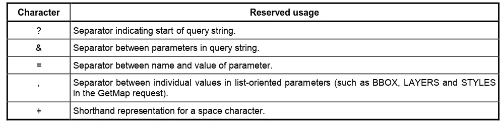
6.3.2 Reserved characters in HTTP GET URLs
The URL specification (IETF RFC 2396) reserves particular characters as significant and requires that these be escaped when they might conflict with their defined usage. This International Standard explicitly reserves several of those characters for use in the query portion of WMS requests. When the characters “?”, “&”, “=”, “,” and “+” appear in one of the roles defined in Table 1, they shall appear literally in the URL. When those characters appear elsewhere (for example, in the value of a parameter), they shall be encoded as defined in IETF RFC 2396.
The server shall be prepared to decode any character escaped in this manner, and to decode the “+” character as a space.
Table 1 — Reserved characters in WMS query string
Character Reserved usage
? Separator indicating start of query string.
& Separator between parameters in query string.
= Separator between name and value of parameter.
, Separator between individual values in list-oriented parameters (such as BBOX, LAYERS and STYLES
in the GetMap request).
+ Shorthand representation for a space character.
6.3.3 HTTP GET
A WMS shall support the “GET” method of the HTTP protocol (IETF RFC 2616).
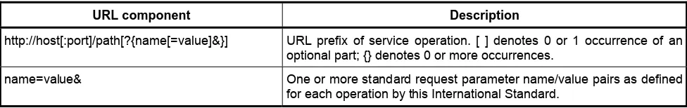
numeric address, optional port number, path, mandatory question mark “?”, and optional string comprising one or more server-specific parameters ending in an ampersand “&”. The prefix defines the network address to which request messages are to be sent for a particular operation on a particular server. Each operation may have a different prefix. Each prefix is entirely at the discretion of the service provider.
This International Standard defines how to construct a query part that is appended to the URL prefix in order to form a complete request message. Every WMS operation has several mandatory or optional request parameters. Each parameter has a defined name. Each parameter may have one or more legal values, which are either defined by this International Standard or are selected by the client based on service metadata. To formulate the query part of the URL, a client shall append the mandatory request parameters, and any desired optional parameters, as name/value pairs in the form “name=value&” (parameter name, equals sign, parameter value, ampersand). The “&” is a separator between name/value pairs, and is therefore optional after the last pair in the request string.
When the HTTP GET method is used, the client-constructed query part is appended to the URL prefix defined by the server, and the resulting complete URL is invoked as defined by HTTP (IETF RFC 2616).
Table 2 — Structure of WMS request using HTTP GET
URL component Description
http://host[:port]/path[?{name[=value]&}] URL prefix of service operation. [ ] denotes 0 or 1 occurrence of an optional part; {} denotes 0 or more occurrences.
name=value& One or more standard request parameter name/value pairs as defined
for each operation by this International Standard.
6.3.4 HTTP POST
A WMS may support the “POST” method of the HTTP protocol (IETF RFC 2616).
An Online Resource URL intended for HTTP POST requests is a complete URL (not merely a prefix as in the HTTP GET case) that is valid according to IETF RFC 2396 to which clients transmit request parameters in the body of the POST message. A WMS shall not require additional parameters to be appended to the URL in order to construct a valid target for the operation request. When POST is used, the request message is formulated as an XML document.
6.4 General HTTP response rules
Upon receiving a valid request, the server shall send a response corresponding exactly to the request as detailed in Clause 7 of this International Standard, or send a service exception if unable to respond correctly. Only in the case of Version Negotiation (see 6.2.4) may the server offer a differing result. Upon receiving an invalid request, the server shall issue a service exception as described in 6.11.
A server may send an HTTP Redirect message (using HTTP response codes as defined in IETF RFC 2616) to an absolute URL that is different from the valid request URL that was sent by the client. HTTP Redirect causes the client to issue a new HTTP request for the new URL. Several redirects could in theory occur. Practically speaking, the redirect sequence ends when the server responds with a WMS response. The final response shall be a WMS response that corresponds exactly to the original request (or a service exception).
Response objects shall be accompanied by the appropriate Multipurpose Internet Mail Extensions (MIME) type (IETF RFC 2045) for that object. A list of MIME types in common use on the internet is maintained by the Internet Assigned Numbers Authority (IANA) [2]. Allowable types for operation responses and service exceptions are discussed below. The basic structure of a MIME type is a string of the form “type/subtype”. MIME allows additional parameters in a string of the form “type/subtype; param1=value1; param2=value2”. A server may include parameterized MIME types in its list of supported output formats. In addition to any parameterized variants, the server should offer the basic unparameterized version of the format.
Response objects should be accompanied by other HTTP entity headers as appropriate and to the extent possible. In particular, the Expires and Last-Modified headers provide important information for caching; Content-Length may be used by clients to know when data transmission is complete and to efficiently allocate space for results, and Content-Encoding or Content-Transfer-Encoding may be necessary for proper interpretation of the results.
6.5 Numeric and Boolean values
Real numbers shall be represented in a manner consistent with the specification for double-precision numbers in XML Schema Datatypes ([8], section 3.2.5). This representation allows for integer, decimal and exponential notations. A real value is allowed in all numeric fields defined by this International Standard unless the value is explicitly restricted to integer.
Positive, negative and zero values are allowed unless explicitly restricted.
Boolean values shall be represented in a manner consistent with the specification for Boolean in XML Schema Datatypes ([8], section 3.2.2). The values “0” and “false” are equivalent. The values “1” and “true” are equivalent. Absence of an optional value is equivalent to logical false. This International Standard shall explicitly indicate where a Boolean value is mandatory.
6.6 Output formats
The response to a Web Map Service request is always a computer file that is transferred over the Internet from the server to the client. The file may contain text, or the file may represent a map image. As stated in 6.4, the type of the returned file shall be indicated by a MIME type string.
Text output formats are usually formatted as Extensible Markup Language (XML; MIME type text/xml). Text formats are used to convey service metadata, descriptions of error conditions, or responses to queries for information about features shown on a map.
Allowed map formats are either “picture” formats or “graphic element” formats. Picture formats constitute a rectangular pixel array of fixed size. Picture formats include file types such as Graphics Interchange Format (GIF; MIME type “image/gif”), Portable Network Graphics (PNG; MIME type “image/png”), Joint Photographics Expert Group (JPEG; MIME type “image/jpeg”), all of which can be displayed by common Web browsers, and file types such as Tagged Image File Format (TIFF: MIME type “image/tiff”) that may require additional software (beyond a basic Web browser) for display. Graphic element formats constitute a scale-independent description of the graphic elements to be displayed (including points, lines, curves, text and images), such that the size of the display may be modified while preserving the relative arrangement of the graphic elements. Graphic element formats include Scalable Vector Graphics (SVG; MIME type “image/svg+xml”) or Web Computer Graphics Metafile (WebCGM; MIME type “image/cgm;Version=4;ProfileId=WebCGM”) formats.
NOTE 1 SVG is expressed using XML, and could therefore be considered to be a text output format, but for the purposes of
this International Standard SVG is considered to be a map format.
NOTE 2 WebCGM is a profile of ISO/IEC 8632.
A server may offer multiple map formats. The formats it offers are enumerated in <Format> elements in its service metadata. Use of a specific format is not required by this International Standard. However, for maps that portray vector features the server should offer at least one format that supports transparency in order that maps may be overlaid without obscuring other maps below (see the discussion about transparency in 7.3.3.9). Also, for ease of use, the server should offer at least one format that can be displayed by common Web browsers without additional software. Based on these considerations, the server should offer at least the PNG format.
6.7 Coordinate systems
6.7.1 Introduction
6.7.2 Map CS
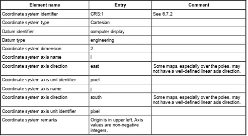
A Map CS is a coordinate reference system for a map produced by a WMS. A WMS map is a rectangular grid of pixels displayed on a computer screen (or a digital file that could be so displayed). The Map CS has a horizontal axis denoted i, and a vertical axis denoted j. i and j shall have only nonnegative integer values. The origin (i,j) = (0,0) is the pixel in the upper left corner of the map; i increases to the right and j increases downward. The Map CS is defined using ISO 19111 terminology in B.2. The Map CS is identified by the label “CRS:1”.
The usual orientation of the Map CS shall be such that the i axis is parallel to the East-to-West axis of the Layer CRS and increases Eastward, and the j axis is parallel to the North-to-South axis of the Layer CRS and increases Southward. This orientation will not be possible in some cases, as (for example) in an orthographic projection over the South Pole. The convention to be followed is that, wherever possible, East shall be to the right edge and North shall be toward the upper edge of the Map CS.
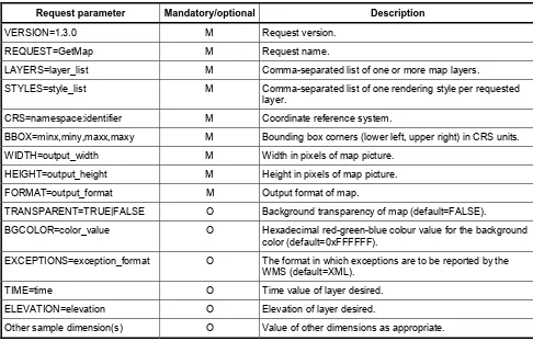
The WIDTH and HEIGHT parameters used in the GetMap request (see 7.3.3.8) and by inclusion in the GetFeatureInfo request (7.4.3.3) correspond to i and j as follows:
⎯ WIDTH denotes the size of the map image in pixels along the i axis (that is, WIDTH-1 is the maximum value of i).
⎯ HEIGHT denotes the size of the map image in pixels along the j axis (that is, HEIGHT-1 is the maximum value of j).
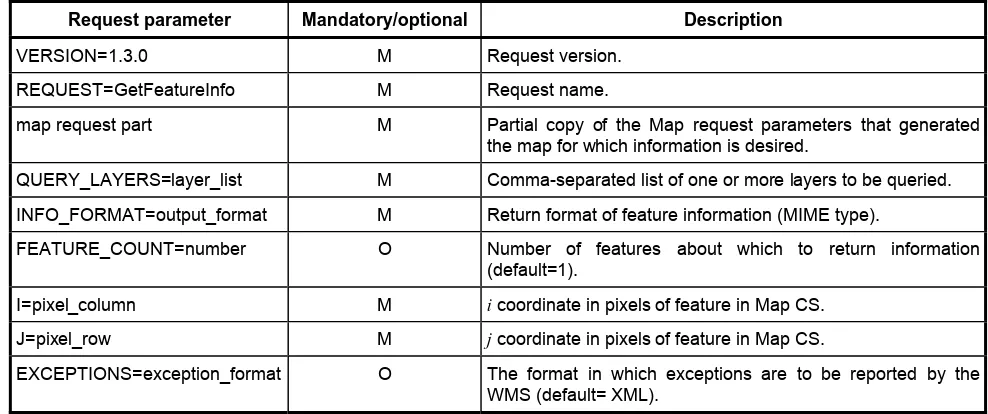
The I and J parameters used in the GetFeatureInfo request (see 7.4.3.7) denote integer values along the i and j axes, respectively, of the Map CS.
6.7.3 Layer CRS
6.7.3.1 Introduction
A Layer CRS is a horizontal coordinate reference system for the geographic information that serves as the source for a map. As discussed below, many Layer CRSs are possible. A Layer CRS appears in the following entities relevant to the WMS:
⎯ the <BoundingBox> element in the service metadata (7.2.4.6.8); ⎯ the CRS parameter in the GetMap request (7.3.3.5);
⎯ the CRS parameter in the map request part of the GetFeatureInfo request (7.4.3.3).
A WMS must support at least one CRS, and maps from multiple servers may be overlaid only if all the selected servers have at least one CRS in common. This International Standard does not mandate support for any particular Layer CRS(s). Instead, it only defines how CRSs are identified and discusses several optional Layer CRSs, in this clause and in Annex B. Map providers may support the CRSs that are most useful and appropriate to their geographic locale or information community. To maximize interoperability among servers, providers should also support geographic coordinates by geocentric coordinate systems such as “CRS:84” (see 6.7.3.2), “EPSG:4326” (see 6.7.3.3) or other ITRF-based systems.
Every Layer CRS has an identifier that is a character string. Two types of Layer CRS identifiers are permitted: “label” and “URL” identifiers:
⎯ URL: The identifier is a fully-qualified URL that references a publicly-accessible file containing a definition of the CRS that is compliant with ISO 19111.
The Layer CRS has two axes, denoted x and y. The x axis is the first axis in the CRS definition, the y axis is the second axis. Depending on the particular CRS, the x axis may or may not be oriented West-to-East, and the y axis may or may not be oriented South-to-North. The WMS portrayal operation shall account for axis order, origin and direction in the Layer CRS when projecting geographic information from a Layer CRS to the Map CS.
Coordinates shall be listed in the order defined by the CRS and shall be mapped appropriately to the Map CS i and j axes, swapping axis order as needed during the projection operation. Many projected coordinate reference systems have an axis and coordinate order other than easting, northing. For example, the Uniform Coordinate System used in Finland (EPSG:2393) orders northing before easting. EPSG geographic coordinate reference systems follow ISO 6709 and always list latitude before longitude.
Most coordinate reference systems are orientated with one axis positive east (easting) and the other axis positive north (northing). These map conveniently to the bounding box i and j axes, respectively. However, some CRSs have coordinates incrementing in other directions. For example, the Hartebeesthoek94/Lo25 system used in South Africa (EPSG:2051) has axes with coordinates incrementing to the west and south. Tests for valid bounding box areas shall recognise and account for the positive orientation of the CRS axes.
In a geographic CRS, latitude shall have values within the range [-90, 90] and longitude shall have values within the range [-180, 180] degrees or equivalent if the CRS definition is in other units. See 7.3.5 regarding the projection of Layer CRS that is a geographic CRS into the Map CS. When the CRS code specifies a geographic 2D coordinate reference system with axes in units other than degrees or in a degree representation other than decimal degrees the representation shall be converted to decimal degrees.
NOTE The use of geographic CRSs with axis order of longitude before latitude differs from historical convention. Users in
the international aviation and marine sectors may expect latitude to be before longitude, and a different coordinate display may have safety implications, especially in an emergency response situation. Although this International Standard does not specify human user interfaces, developers of user interfaces for WMSs are cautioned that all references to latitude and longitude, for example user input of bounding box or readout of cursor coordinates, should show latitude before longitude.
6.7.3.2 CRS namespace for CRS
The “CRS” namespace prefix refers to coordinate reference systems that are defined in Annex B of this International Standard. These definitions are in the form specified by ISO 19111. Geographic CRSs in the “CRS” namespace are defined in Annex B for the WGS 84, NAD27 and NAD83 datums.
A “CRS” CRS label comprises the “CRS” prefix, the colon, and a numeric or string code.
EXAMPLE “CRS:84” refers to WGS 84 geographic longitude and latitude expressed in decimal degrees, with longitude
ranging from −180 degrees to +180 degrees and latitude from −90 degrees to +90 degrees.
6.7.3.3 EPSG namespace for CRS
The “EPSG” namespace prefix refers to the European Petroleum Survey Group geodetic dataset (EPSG), which defines numeric identifiers (the EPSG “CRS code,” corresponding to the field “COORD_REF_SYS_CODE” in the EPSG dataset) for many common coordinate reference systems. Defining geodetic, map projection and coordinate reference system data is related to each CRS identifier.
An “EPSG” CRS label comprises the “EPSG” prefix, the colon, and a numeric code.
EXAMPLE EPSG:4326 refers to WGS 84 geographic latitude, then longitude. That is, in this CRS the x axis corresponds
NOTE EPSG geographic coordinate reference systems with axes of “degree – vendor-defined representation” are taken in this International Standard to be in decimal degrees.
6.7.3.4 AUTO2 namespace for CRS
The “AUTO2” namespace is used for “automatic” coordinate reference systems; that is, for a class of CRSs that include a user-selected centre of projection. Several “AUTO2” CRSs are defined in Annex B.
A complete “AUTO2” CRS label comprises the “AUTO2” namespace prefix, a numeric CRS identifier from the AUTO2 namespace, a number indicating what conversion factor to apply to convert between bounding box units and AUTO2 CRS units, and values for the central longitude and latitude in degrees:
AUTO2:auto_crs_id,factor,lon0,lat0
The conversion factor shall be nonzero and positive. If factor=1, then the units of the BBOX values are the same as those stated in the CRS definition. If factor is not 1, then factor is the ratio of BBOX units to CRS units. In a GetMap request, the complete AUTO2 CRS is specified, including longitude, latitude and units. In service metadata, the longitude, latitude and units variables are omitted because they are chosen by the client in a request for an AUTO2 CRS.
EXAMPLE 1 A server indicates that it supports Auto Orthographic CRS by including the element
“<CRS>AUTO2:42003</CRS>” in its service metadata. A client may issue a GetMap request for a map in this CRS, with bounding box in meters, centered at 100 degrees West longitude and 45 degrees North latitude, using the parameter “CRS=AUTO2:42003,1,-100,45”.
EXAMPLE 2 Same request as in example 1, but with conversion factor allowing bounding box in U.S. feet:
"CRS=AUTO2:42003,0.3048006096012192,-100,45".
6.7.3.5 Geographic information with undefined CRS
A server may offer two-dimensional geographic information whose precise spatial reference is undefined. For example, a hand-drawn historical map may represent an area of the Earth but not employ a modern coordinate reference system, and an aerial photograph may not be precisely georeferenced. Such types of graphical information shall be treated as an image, and the Map CS label “CRS:1” shall be used when declaring the Layer CRS of such an object. Clients should not attempt to overlay a layer for which CRS=CRS:1 with another layer.
6.7.4 Bounding boxes
Bounding box values specify the portion of the Earth to be mapped through two pairs of coordinates in a specified Layer CRS. The first pair specifies the minimum coordinate values in the Layer CRS, the second specifies maximum coordinate values. Although for most CRSs with axes incrementing to the east and north this would be the lower left and upper right corners of the area of interest, the minimum and maximum values might be at other points in some instances. For example, when using geographic coordinates to describe an area over a pole, or when the layer CRS axes increment in directions other than east and north. The order in which ordinates in each pair are listed shall be as defined by the Layer CRS; x corresponds to the first axis in the Layer CRS and y to the second. This order may not coincide with the Map CS axis order i, j. The bounding box coordinate values shall be in the units defined for the Layer CRS.
NOTE The use of two corner points to specify the map region is not the only possible method in theory. Other possibilities
include specifying a central point and a radius, or a central point and a zoom level or scale. Some services that use mapping (e.g. location-based services) may find a formalism based on the central point more appropriate. This International Standard is not intended to preclude other service types from using other map region definitions internally or in client interactions. For most coordinate reference systems, it is a simple mathematical operation to transform between corner-point and central-point methods. Thus, for example, user input of a central point and radius could be converted to a two-point bounding box when requesting a map from a WMS that implements this International Standard.
⎯ the <BoundingBox> element in the service metadata (7.2.4.6.8); ⎯ the BBOX parameter in the GetMap request (7.3.3.6);
⎯ the BBOX parameter in the map request part of the GetFeatureInfo request (7.4.3.3).
A Bounding Box shall not have zero area.
EXAMPLE 1 A <BoundingBox> metadata element for a Layer representing the entire Earth in the CRS:84 Layer CRS
would be written as
<BoundingBox CRS="CRS:84" minx="-180" miny="-90" maxx="180" maxy="90">. A BBOX parameter requesting a map of the entire Earth would be written in this CRS as BBOX=-180,-90,180,90.
EXAMPLE 2 A <BoundingBox> representing the entire Earth in the EPSG:4326 Layer CRS would be written as
<BoundingBox CRS="EPSG:4326" minx="-90" miny="-180" maxx="90" maxy="180">. A BBOX parameter requesting a map of the entire Earth would be written in this CRS as
BBOX=-90,-180,90,180.
6.7.5 Vertical CRS
Some geographic information may be available at multiple elevations (for example, ozone concentrations at different heights in the atmosphere). A WMS may announce available elevations in its service metadata, and the GetMap operation includes an optional parameter for requesting a particular elevation. A single elevation or depth value is a number whose units, and the direction in which ordinates increment, are declared through a one-dimensional vertical CRS. Depending on the context, elevation values may appear as a single value, a list of values, or an interval, as specified in Annex C.
A server may declare at most one vertical CRS for each layer. For the purposes of this International Standard, the horizontal and vertical CRSs are treated as independent metadata elements and request parameters.
A request for a map at a specific elevation includes an elevation value but does not include the vertical CRS identifier (the horizontal CRS, which is included along with the horizontal bounding box in the request parameters). When providing elevation information, a server should declare a default value in service metadata, and a server shall respond with the default value if one has been declared and the client request does not include a value. Two types of Vertical CRS identifiers are permitted: “label” and “URL” identifiers:
⎯ Label: The identifier includes a namespace prefix, a colon, and a numeric or string code. B.6 defines an optional vertical CRS labelled “CRS:88” based on the North American Vertical Datum 1988. If the namespace prefix is “EPSG”, then the vertical CRS is one of those defined in the European Petroleum Survey Group database.
⎯ URL: The identifier is a fully-qualified Uniform Resource Locator that references a publicly-accessible file containing a definition of the CRS that is compliant with ISO 19111.
If the height is the vertical component of a dimensional CRS, the Vertical CRS identifier shall be that of the 3-dimensional CRS.
6.7.6 Temporal CS
temporal information, a server should declare a default value in service metadata, and a server shall respond with the default value if one has been declared and the client request does not include a value.
6.7.7 Other coordinate systems
Some geographic information may be available at other dimensions (for example, satellite images in different wavelength bands). The dimensions other than the four space-time dimensions are referred to as “sample dimensions”. A WMS may announce available sample dimensions in its service metadata, and the GetMap operation includes a mechanism for requesting dimensional values. Each sample dimension has a Name and one or more valid values. The declaration and use of sample dimensions are specified in C.3.3.
6.8 Request parameter rules
6.8.1 Parameter ordering and case
Parameter names shall not be case sensitive, but parameter values shall be. In this International Standard, parameter names are typically shown in uppercase for typographical clarity, not as a requirement.
Parameters in a request may be specified in any order.
When request parameters are duplicated with conflicting values, the response from the server may be undefined. This International Standard does not mandate which of the duplicated values sent by the client are to be used by the server.
A WMS shall be prepared to encounter additional request parameters that are not part of this International Standard. In terms of producing results per this International Standard, a WMS shall not require such parameters.
6.8.2 Parameter lists
Parameters consisting of lists (for example, BBOX, LAYERS and STYLES in WMS GetMap) shall use the comma (“,”) as the separator between items in the list. Additional white space shall not be used to delimit list items. If a list item value includes a space or comma, it shall be escaped using the URL encoding rules (see 6.3.2 and IETF RFC 2396).
In some lists, individual entries may be empty, and shall be represented by the empty string (“”). Thus, two successive commas indicate an empty item, as does a leading comma or a trailing comma. An empty list (“”) shall be interpreted either as a list containing no items or as a list containing a single empty item, depending on context.
6.9 Common request parameters
6.9.1 VERSION
The VERSION parameter specifies the protocol version number. The format of the version number, and version negotiation, are described in 6.2.
6.9.2 REQUEST
The REQUEST parameter indicates which service operation is being invoked. The value shall be the name of one of the operations offered by the server.
6.9.3 FORMAT
A WMS may offer only a subset of the formats known for that type of operation. The server shall advertise in its service metadata those formats it does support and shall accept requests for any format it advertises. A server may optionally offer a new format not previously offered by other instances, with the recognition that clients shall not be required to accept or process an unknown format. If a request contains a format not offered by a particular server, the server shall respond with the default format for that operation if one has been defined, or throw a service exception (with code “InvalidFormat”) if no default has been defined.
A client may accept only a subset of the formats known for that type of operation. If a client and server do not support any mutually agreeable formats, the client may, at its discretion, cease communicating with that server, or search for an intermediary service provider that performs format conversion, or allow the user to choose other disposition methods (e.g. saving to local storage or passing to a helper application).
Formats are expressed in both service metadata and in operation requests using MIME types. Each operation has a distinct list of supported formats. Some formats may be offered by several operations, and are then duplicated as needed in each list.
6.9.4 EXCEPTIONS
The EXCEPTIONS request parameter states the format in which to report errors (see 6.11).
6.9.5 Extended capabilities and operations
The Web Map Service allows for optional extended capabilities and operations. Extensions may be defined within an information community when needed for additional functionality or specialization. A generic client shall not be required or expected to make use of such extensions. Extended capabilities or operations shall be defined when necessary by providing instances of the abstract <_ExtendedCapabilities> or <_ExtendedOperations> elements in the service metadata schema in Annex E. Extended capabilities provide additional metadata about the service, and may or may not enable optional new parameters to be included in operation requests. Extended operations allow additional operations to be defined.
A server shall produce a valid response to the operations defined in this International Standard, even if parameters used by extended capabilities are missing or malformed (i.e. the server shall supply a default value for any extended capabilities it defines), or if parameters are supplied that are not known to the server.
Service providers shall choose extension names with care to avoid conflicting with standard metadata fields, parameters and operations.
6.10 Service result
The return value of a valid Service request shall correspond to the type requested in the FORMAT parameter. In an HTTP environment, the Content-type header of the response shall be exactly the MIME type given in the valid request.
6.11 Service exceptions
Upon receiving a request that is invalid according to this International Standard, the server shall issue a service exception report. The service exception report is meant to describe to the client application or its human user the reason(s) that the request is invalid. The EXCEPTIONS parameter in a request indicates the format in which the client wishes to be notified of service exceptions. The allowed service exception formats are defined for each operation below.
be unable to process the WMS request and may issue an error message. Or, upon receiving a request that is invalid according to the rules of the Distributed Computing Platform in use, the server may issue a service exception of a type valid in that DCP (e.g. if the URL prefix is incorrect, an HTTP 404 status code (IETF RFC 2616) may be sent).
7 Web Map Service operations
7.1 Introduction
The three operations defined for a WMS are GetCapabilities, GetMap, and GetFeatureInfo. GetFeatureInfo is optional. This clause specifies the implementation and use of these WMS operations in the Hypertext Transfer Protocol (HTTP) Distributed Computing Platform (DCP).
7.2 GetCapabilities (mandatory)
7.2.1 General
The purpose of the mandatory GetCapabilities operation is to obtain service metadata, which is a machine-readable (and human-machine-readable) description of the server’s information content and acceptable request parameter values.
7.2.2 GetCapabilities request overview
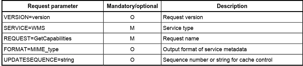
The general form of a WMS request is defined in 6.3.3 and 6.3.4. When making the GetCapabilities request of a WMS server, which may offer other service types as well, it is necessary to indicate that the client seeks information about the Web Map Service in particular. Thus, the SERVICE parameter of the request shall have the value “WMS” as shown in Table 3.
Table 3 — The parameters of a GetCapabilities request URL
Request parameter Mandatory/optional Description
VERSION=version O Request version
SERVICE=WMS M Service type
REQUEST=GetCapabilities M Request name
FORMAT=MIME_type O Output format of service metadata
UPDATESEQUENCE=string O Sequence number or string for cache control
7.2.3 Request parameters
7.2.3.1 FORMAT
Content-type entity header. If the request specifies a format not supported by the server, the server shall respond with the default text/xml format.
7.2.3.2 VERSION
The optional VERSION parameter, and its use in version negotiation, is defined in 6.2.
7.2.3.3 SERVICE
The mandatory SERVICE parameter indicates which of the available service types at a particular server is being invoked. When invoking GetCapabilities on a WMS that implements this version of the International Standard or a later one, the value “WMS” shall be used.
7.2.3.4 REQUEST
The nature of the mandatory REQUEST parameter is defined in 6.9.2. To invoke the GetCapabilities operation, the value “GetCapabilities” shall be used.
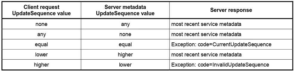
7.2.3.5 UPDATESEQUENCE
The optional UPDATESEQUENCE parameter is for maintaining cache consistency. Its value can be either an integer, or a string that represents a timestamp in ISO 8601:2004 format (see Annex D), or any other string. The server may include an UpdateSequence value in its service metadata. If present, this value should be increased when changes are made to the Capabilities (e.g. when new maps are added to the service). The client may include this parameter in its GetCapabilities request. The response of the server based on the presence and relative value of UpdateSequence in the client request and the server metadata shall be according to Table 4.
Table 4 — Use of UpdateSequence parameter
Client request UpdateSequence value
Server metadata
UpdateSequence value Server response
none any most recent service metadata
any none most recent service metadata
equal equal Exception: code=CurrentUpdateSequence
lower higher most recent service metadata
higher lower Exception: code=InvalidUpdateSequence
7.2.4 GetCapabilities response
7.2.4.1 Introduction
A server may comply with other published or experimental protocol versions, in which case it shall support version negotiation as described in 6.2.
7.2.4.2 Names and titles
A number of elements have both a <Name> and a <Title>. The Name is a text string used for machine-to-machine communication while the Title is for the benefit of humans. For example, a dataset might have the descriptive Title “Maximum Atmospheric Temperature” and be requested using the abbreviated Name “ATMAX”.
7.2.4.3 General service metadata
The first part of the service metadata is a <Service> element providing general metadata for the server as a whole. It shall include a Name, Title, and Online Resource URL. Optional service metadata includes Abstract, Keyword List, Contact Information, Fees, Access Constraints, and limits on the number of layers in a request or the output size of maps.
The Service Name shall be “WMS” in the case of a WMS.
The Service Title is at the discretion of the provider, and should be brief yet descriptive enough to identify this server in a menu with other servers.
The Abstract element allows a descriptive narrative providing more information about the enclosing object. The OnlineResource element within the Service element may be used to refer to the web site of the service provider. There are other OnlineResource elements used for the URL prefix of each supported operation (see below).
A list of keywords or keyword phrases describing the server as a whole should be included to help catalogue searching. Each keyword may be accompanied by a “vocabulary” attribute to indicate the defining authority for that keyword. One “vocabulary” attribute value is defined by this International Standard: the value “ISO 19115:2003” refers to the metadata topic category codes defined in ISO 19115:2003, B.5.27; information communities may define other “vocabulary” attribute values. No particular vocabulary is mandated by this International Standard.
Contact Information should be included.
The optional <LayerLimit> element in the service metadata is a positive integer indicating the maximum number of layers a client is permitted to include in a single GetMap request. If this element is absent, the server imposes no limit.
The optional <MaxWidth> and <MaxHeight> elements in the service metadata are positive integers indicating the maximum width and height values that a client is permitted to include in a single GetMap request. If either element is absent the server imposes no limit on the corresponding parameter.
The optional elements <Fees> and <AccessConstraints> may be omitted if they do not apply to the server. If either of those elements is present, the reserved word “none” (case-insensitive) shall be used if there are no fees or access constraints, as follows: <Fees>none</Fees>, <AccessConstraints>none</AccessConstraints>. When constraints are imposed, no precise syntax has been defined for the text content of these elements, but client applications may display the content for user information and action.
7.2.4.4 Capability metadata
placeholders for Distributed Computing Platforms other than HTTP, but currently only the HTTP platform is defined.
7.2.4.5 Layers and styles
The most critical parts of the WMS service metadata are the Layers and Styles it defines. The geographic information content offered for portrayal by a WMS server is organized into “layers”: metadata about the content is subdivided into descriptions of each layer, and a request for a map names one or more layers. The terms “layer” and “map” are defined in Clause 4; the relationship between them in the context of this International Standard is that a map is the result of a request to portray information represented by a layer.
The Web Map Service provider decides what information to include, exclude or aggregate in each layer. However, each layer should be documented in accordance with ISO 19115 or FGDC-STD-001-1998 [1], and a link to that metadata should be provided in the <MetadataURL> element defined below.
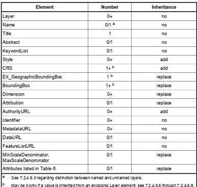
Each available map is advertised by a <Layer> element in the service metadata. Conceptually, each Layer is a distinct entity. However, as a means of classifying and organizing layers, and as a means of reducing the size of the service metadata, a single parent Layer may enclose any number of additional layers, which may be hierarchically nested as desired. Some properties defined in a parent layer are inherited by the children it encloses. These inherited properties may be either redefined or added to by the child. Subclause 7.2.4.8 summarizes whether or how each property is inherited.
A server shall include at least one <Layer> element for each map layer offered. If desired, layers may be repeated in different categories (i.e. enclosed in more than one parent <Layer>) when relevant.
A list of keywords or keyword phrases describing each layer should be included to help catalogue searching. Each keyword may be accompanied by a “vocabulary” attribute to indicate the defining authority for the keyword (see 7.2.4.3).
No controlled vocabulary of Layer and Style Names or Titles is defined by this International Standard, so they may be chosen at the discretion of the service provider organization or information community.
7.2.4.6 Layer properties
7.2.4.6.1 Introduction
The <Layer> element can enclose child elements providing metadata about the Layer. The meanings of those metadata elements are defined in this subclause. The values of some of these elements are inherited by subsidiary layers as defined in 7.2.4.8.
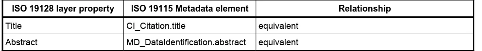
Some of the metadata values, and additional metadata, may be available in ISO 19115 or FGDC-STD-001-1998 [1] format as referenced via the <MetadataURL> element defined below. Table 5 shows the relationship between Layer Properties in this International Standard and ISO 19115 metadata elements. When documenting layers with ISO 19115 metadata, service providers should ensure that fields listed as equivalent in Table 5 have identical values in the full 19115 and in the summary 19128 layer properties.
Table 5 — Relationship between ISO 19128 and ISO 19115 metadata fields
ISO 19128 layer property ISO 19115 Metadata element Relationship
Title CI_Citation.title equivalent
Keyword element in KeywordList
MD_TopicCategoryCode equivalent if “vocabulary” attribute of 19128
<Keyword> element is “ISO 19115:2003”. Other vocabularies are permitted by 19128.
EX_GeographicBoundingBox EX_GeographicBoundingBox equivalent
CRS MD_CRS Value of CRS in 19128 is a text string that identifies a
coordinate reference system defined by another authority. Value of MD_CRS in 19115 is a list of projection, ellipsoid and datum identifiers.
BoundingBox EX_BoundingPolygon 19128:BoundingBox is strictly a box (lower left and
upper right corners in a specified CRS).
19115:EX_BoundingPolygon may be a polygonal boundary.
Attribution CI_ResponsibleParty Title element of 19128:Attribution is equivalent to
organisationName element of 19115: CI_ResponsibleParty. Other elements of 19128:Attribution have no equivalent in 19115.
Identifier and AuthorityURL CI_Citation.identifier The value of 19128:Identifier is equivalent to
19115:CI_Citation.identifier.code.
19128:AuthorityURL contains only the URL of the authority for a namespace, and is equivalent to 19115: CI_Citation.identifier.citation.citedResponsibleParty. contactInfo.onlineResource. 19115 allows a fuller description of the namespace authority.
DataURL MD_metadata.dataSetURI equivalent
7.2.4.6.2 Title
A <Title> is mandatory for all layers; it is a human-readable string for presentation in a menu. The Title is not inherited by child Layers.
7.2.4.6.3 Name
If, and only if, a layer has a <Name>, then it is a map layer that can be requested by using that Name in the LAYERS parameter of a GetMap request. A Layer that contains a <Name> element is referred to as a “named layer” in this International Standard. If the layer has a Title but no Name, then that layer is only a category title for all the layers nested within. A server that advertises a Layer containing a Name element shall be able to accept that Name as the value of LAYERS argument in a GetMap request and return the corresponding map. A client shall not attempt to request a layer that has a Title but no Name.
A server shall throw a service exception (code="LayerNotDefined") if an invalid layer is requested.
A containing category itself may include a Name by which a map portraying all of the nested layers can be requested at once. For example, a parent layer "Roads" may have children “Interstates” and “State Highways” and allow the user to request either child individually or both together.
The Name is not inherited by child Layers.
7.2.4.6.4 Abstract and KeywordList
7.2.4.6.5 Style
Zero or more Styles may be advertised for a Layer or collection of layers using <Style> elements, each of which shall have <Name> and <Title> elements. The style's Name is used in the Map request STYLES parameter. The Title is a human-readable string. If only a single style is available, that style is known as the “default” style and need not be advertised by the server.
A <Style> may contain several other elements. <Abstract> provides a narrative description while <LegendURL> contains the location of an image of a map legend appropriate to the enclosing style. A <Format> element in LegendURL indicates the MIME type of the legend image, and the optional attributes width and height state the size of the image in pixels. Servers should provide the width and height attributes if known at the time of processing the GetCapabilities request. The legend image should clearly represent the symbols, lines and colours used in the map portrayal. The legend image should not contain text that duplicates the Title of the layer, because that information is known to the client and may be shown to the user by other means.
Style declarations are inherited by child Layers. A child shall not redefine a Style with the same Name as one inherited from a parent. A child may define a new Style with a new Name that is not available for the parent Layer.
7.2.4.6.6 EX_GeographicBoundingBox
Every named Layer shall have exactly one <EX_GeographicBoundingBox> element that is either stated explicitly or inherited from a parent Layer. EX_GeographicBoundingBox states, via the elements westBoundLongitude, eastBoundLongitude, southBoundLatitude, and northBoundLatitude, the minimum bounding rectangle in decimal degrees of the area covered by the Layer. EX_GeographicBoundingBox shall be supplied regardless of what CRS the map server may support, but it may be approximate if the data are not natively in geographic coordinates. The purpose of EX_GeographicBoundingBox is to facilitate geographic searches without requiring coordinate transformations by the search engine.
7.2.4.6.7 CRS
Every Layer is available in one or more layer coordinate reference systems. 6.7.3 discusses the Layer CRS. In order to indicate which Layer CRSs are available, every named Layer shall have at least one <CRS> element that is either stated explicitly or inherited from a parent Layer. The root <Layer> element shall include a sequence of zero or more CRS elements listing all CRSs that are common to all subsidiary layers. A child layer may optionally add to the list inherited from a parent layer. Any duplication shall be ignored by clients.
When a Layer is available in several coordinate reference systems, the list of available CRS values shall be represented as a sequence of <CRS> elements, each of which contains only a single CRS name.
EXAMPLE <CRS>CRS:84</CRS> <CRS>EPSG:26718</CRS>.
7.2.4.6.8 BoundingBox
WMS service metadata shall declare one or more bounding boxes (as defined in 6.7.4) for each Layer. A Bounding Box metadata element may either be stated explicitly or may be inherited from a parent Layer. In XML, the <BoundingBox> metadata element includes the following attributes:
⎯ CRS indicates the Layer CRS that applies to this bounding box.
⎯ minx, miny, maxx, maxy indicate the limits of the bounding box using the axis units and order of the specified CRS.
⎯ resx and resy (optional) indicate the spatial resolution of the data comprising the layer in those same units.
BBOX request parameter, on the other hand, specifies which area is to be portrayed on the map. The BBOX area may or may not overlap, contain, or be contained within the BoundingBox area.
A Layer may have multiple BoundingBox elements, but each one shall state a different CRS. A Layer inherits any BoundingBox values defined by its parents. A BoundingBox inherited from the parent Layer for a particular CRS is replaced by any declaration for the same CRS in the child Layer. A BoundingBox in the child for a new CRS not already declared by the parent is added to the list of bounding boxes for the child Layer. A single Layer element shall not contain more than one BoundingBox for the same CRS.
NOTE There is no provision for describing disjoint bounding boxes. For example, consider a dataset which covers two
areas separated by some distance. The server cannot provide two separate bounding boxes in the same Layer using the same CRS to separately describe those areas. To handle this type of situation, the server may either define a single larger bounding box which encloses both areas, or may define two separate Layers that each have distinct Name and BoundingBox values.
A Layer shall not provide a BoundingBox for a CRS it does not support. Conversely, a Layer may support CRSs for which it does not provide a BoundingBox: a server that has the ability to transform data to different CRSs may choose not to provide an explicit BoundingBox for every possible CRS available for each Layer. The server should provide BoundingBox information for at least the native CRS of the Layer (that is, the CRS in which the Layer is stored in the server’s database).
The <EX_GeographicBoundingBox> element (see 7.2.4.6.6) is conceptually similar to a BoundingBox in which the attribute CRS="CRS:84" is implicit. However, <EX_GeographicBoundingBox> shall not be used as a substitute for <BoundingBox CRS="CRS:84">. If the server wishes to provide bounding box information in the CRS:84 CRS, then a separate BoundingBox element explicitly naming CRS:84 shall be included in the service metadata.
If the Layer CRS is "CRS:1" (Map CS; see B.2), then the BoundingBox units are pixels, the origin is at the upper left, the first (x) axis increases to the right, and the second (y) axis increases toward the bottom.
7.2.4.6.9 Scale denominators
The <MinScaleDenominator> and <MaxScaleDenominator> elements define the range of scales for which it is appropriate to generate a map of a Layer. Because maps from a WMS may be viewed on arbitrary displays rather than on paper, the values used are actually the scale denominators relative to a common display pixel size. The intent of scale denominators is not that the translation between “actual” and “standard” scales always be completely accurate. Rather, the intent is to reduce the amount of clutter or crowding of features portrayed on the map. The scale denominator values are guidelines for clients, not firm limits. Upon receiving a request for a map that is not within the scale denominator range, the server may return a blank map, or may return a portrayal of the Layer that is crowded with features or otherwise poorly suited for display; the server shall not respond with a service exception.
For the purposes of this International Standard, the common pixel size is defined to be 0,28 mm × 0,28 mm. Because arbitrary clients can request maps from a server, the true pixel size of the final rendering device is unknown to the server.
EXAMPLE A scale denominator value of “10000000” means a scale of 1:10 million. Scientific notation is also allowed, so
a more compact value of “10e6” could also be used for the scale denominator.
The MinScaleDenominator and MaxScaleDenominator elements, as their names suggest, define the range of scale denominators of maps for which a Layer is appropriate. The minimum scale is inclusive and the maximum scale is exclusive. So, for example, the following scale range:
<MinScaleDenominator>1e3</MinScaleDenominator>