INDICATOR SPECIES POPULATION MONITORING IN ANTARCTICA WITH UAV
A. Zmarz a,, M. Korczak-Abshire bR. Storvold c, M. Rodzewicz d, I. Kędzierskab
Corresponding author
a
Depart. of Geoinformatics, Cartography and Remote Sensing, University of Warsaw, Faculty of Geography and Regional Studies,
Krakowskie Przedmieście 30, 00-927 Warsaw, Poland - [email protected]
b
Depart. of Antarctic Biology, Institute of Biochemistry and Biophysics Polish Academy of Sciences, Ustrzycka 10/12, 02-141 Warsaw, Poland - [email protected]
c
Northern Research Institute Tromsø, P.O.Box 6434, 9294 Tromsø, Norway - [email protected]
d Institute of Aeronautics and Applied Mechanics, Warsaw University of Technology, Nowowiejska 24, 00-665 Warsaw,
KEY WORDS: Indicator species, penguins, monitoring, Antarctica, UAV.
ABSTRACT:
A program to monitor bird and pinniped species in the vicinity of Arctowski Station, King George Island, South Shetlands, Antarctica, has been conducted over the past 38 years. Annual monitoring of these indicator species includes estimations of breeding population sizes of three Pygoscelis penguin species: Adélie, gentoo and chinstrap. Six penguin colonies situated on the western shores of two bays: Admiralty and King George are investigated.
To study changes in penguin populations Unmanned Aerial Vehicles were used for the first time in the 2014/15 austral summer season. During photogrammetric flights the high-resolution images of eight penguin breeding colonies were taken. Obtained high resolution images were used for estimation of breeding population size and compared with the results of measurements taken at the same time from the ground. During this Antarctic expedition eight successful photogrammetry missions (total distance 1500 km) were performed. Images were taken with digital SLR Canon 700D, Nikon D5300, Nikon D5100 with a 35mm objective lens. Flights altitude at 350 – 400 AGL, allowed images to be taken with a resolution GSD (ground sample distance) less than 5 cm. The Image J software analysis method was tested to provide automatic population estimates from obtained images. The use of UAV for monitoring of indicator species, enabled data acquisition from areas inaccessible by ground methods.
1. INTRODUCTION
1.1 Project MONICA
In the Antarctic summer season 2014/2015 Polish-Norwegian project: "A novel approach is the monitoring of the impact of climate change on Antarctic ecosystems - MONICA" was started. The main goal of this project is to study the impact of climate change on Antarctic ecosystem and biodiversity. Data presented here is an important contribution to the monitoring of the ecosystem as recommended by the Convention for the Conservation of Antarctic Marine Living Resources (CCAMLR). Two UAVs (PW-ZOOM, CryoWing) specially designed to work in polar conditions were used in order to perform the tasks of estimating breeding population size of indicator species (Korczak-Abshire, 2014).
2. AIRCRAFT AND INSTRUMENTATION
2.1 PW-ZOOM Unmanned Photogrammetric Aircraft
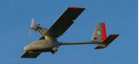
A special UAV, which is able to carry a high-resolution camera and to make autonomous photogrammetry missions was designed by the WUT partner of consortium (Hajduk, 2014). The plane was named PW-ZOOM (Figure1). Basic data of the plane: wing span - 3,5 meters, fuselage length – 1,7m, take-off weight 23 kg, cruising speed 115 km/h, flying range – 170 km. Apart from photogrammetry equipment:
• Canon 700D, digital SLR camera with Canon 35mm f/2.0 objective lens
• Nikon D5300 digital SLR camera with a Nikon 35mm f/2.0 objective lens
the PW-ZOOM was equipped with radio-control system, autopilot (Micropilot 2128g), telemetry modems (SATELLINE YM 6500), the recovery parachute system.
Figure 1. PW-ZOOM.
optimization of aerodynamic characteristics following from the appropriate combination of geometric parameters, wing-loading and airfoil applied in the wings.
An integration of the autopilot with the airplane means much more than simple installing the autopilot on the airplane board, because this process mainly consists of proper setting of the autopilot parameters responsible for stabilization function and the parameters responsible for navigation function as well. The dynamic properties of the plane were taken into account as well, especially: cruising speed, turn radius, time necessary for reversion of the bank angle when turning direction has to be changed, increase of power consumption necessary for passing from the straight flight to turning at a fixed altitude, etc. Another factor considered by the authors were the control laws and navigation algorithms applied in the autopilot. The integration process was initially based on calculations, but final adjustment of all autopilot parameters was verified in an experimental way prior to the Antarctic expedition.
2.2 CryoWing Unmanned Aircraft
The CryoWing UAS (Solbø, 2013) was designed as a platform
to carry science payloads for research within meteorology, climate, environment and Earth observation disciplines. The CryoWing (Figure 2) can carry up to 10 kg payload, and has a maximum range and endurance of 500 km and 5 hours, respectively. Though the complete CryoWing system is limited to Norut's (and partner institutions) in-house use, the system is assembled mainly from off-the-shelf components, and third party manufacturers utilize the same airframe in turn-key solutions (more information on web site, http://uas.norut.no).
Figure 2. The CryoWing UAS.
The CryoWing can carry a wide variety of payload configurations. The core of the payload system is a computer for instrument control, data storage, data time stamping and communication routing. This payload computer, which runs a linux OS, is tightly connected to the power supply module that provides power to the system. This yields the opportunity to monitor the current consumption for each component, and the different instruments can be powered up and down when needed. Experience has shown that the ability to power cycle instruments can be essential to ensure measurements through long flights, especially for consumer grade cameras that are neither designed for automated operations, nor continuous measurements through several hours.
The operator on the ground is provided control and status for each instrument through a web interface on the ground station. In addition, if the required bandwidth is available, sample data
when within radio line of sight, with a fallback to Iridium satellite modem. The radio link is shared between flight control and payload communication, with flight control data prioritized. In addition there is a separate 2.4GHz link for manual control of the aircraft, used for launching and landing.
For this experiment the payload consisted of the following instrumentation:
• XsensMTi-G Inertial measurement and GPS unit (Xsens Technologies B.V., 2013).
• ICI 7640 LWIR camera (Infrared Cameras Inc., 2012)
• Nikon D5100 digital SLR camera with a Nikon 35mm f/1.8 objective lens.
The IMU was sampled at 100Hz, whereas the GPS receiver at 4Hz and the IR camera at 1Hz, respectively. The Nikon D5100 shot images roughly every 2 seconds, the frequency of image acquisition is limited by the bandwidth of the USB bus that transfers the images to the camera.
3. FLIGHT PLAN
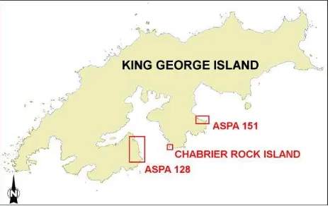
Flights have been designed over two protected areas: ASPA 128 (Admiralty Bay) and ASPA 151 (King George Bay) , as well as Chabrier Rock Island (Figure 3). Creation of a flight plan was dependent on the size of the area, the atmospheric conditions on the day of the flight and the flight characteristics of the UAV. The target area size determines the manner in which the flight is planned and was related to the technical abilities of the UAV.
Depending on the actual size of the target, the image-taking operation were realized using a single flight or were divided into a number of related flights due to the target's shape and the UAV abilities (e.g. maximum flight length) and the safety rules. Flights performed over ASPA 128 covered 30% of its total polygon (18.04 km2) and over the entire surface of ASPA 151 (1.32 km2).
Figure 3. Investigated areas: Antarctic Specially Protected Areas (ASPA) no.128 and 151, as well as Chabrier Rock Island.
4. GROUND CENSUS
breeding colonies of chinstrap penguin and three mixed colonies in ASPA 128 (Chwedorzewska and Korczak 2010) and ASPA 151 (Korczak-Abshire et al. 2012). In all mixed colonies all three species were nesting and occupying the same niche. In these six selected colonies one week after the peak of egg-laying the number of occupied nests were counted by three independent observers. Three separate counts were done of each of the breeding group in the colony on the same day. If one of the three counts differs more than 10% from the others, a fourth was made on the same day as the other three counts. If the results differ no more then by 10%, the mean value was calculated. These mean values were compared with results of photo interpretation of obtained UAV images counted manually and automatically for selected groups.
Figure 4. Ground censuses of penguin nests according to CEMP standard methods.
5. IMAGE ANALYSIS
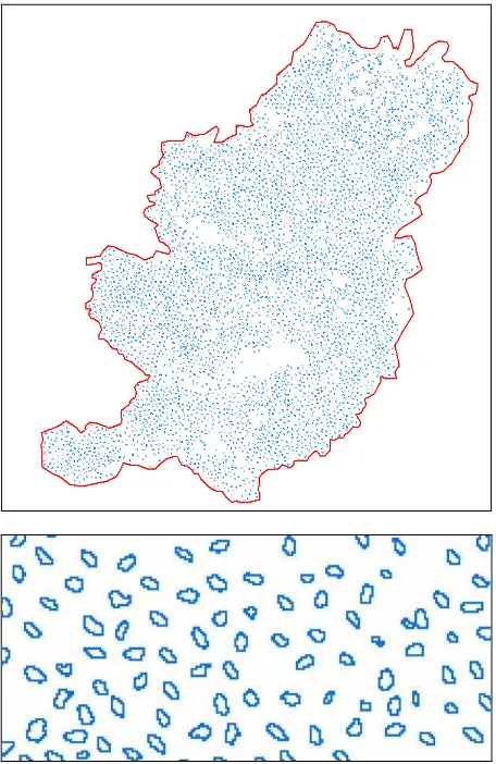
Precision estimation of individual nests count was based on the photo interpretation of obtained UAV images of ASPA 151 penguin colony, particularly three selected breeding groups of
Adélie penguin species. Small, medium and large in size breeding groups were chosen for this analysis (Figure 6). To automatically estimate the size of the colony of penguins, used images in JPEG format. The JPEG images were analysed using the Image J software (version 1.43q). A region of interest polygon was drawn over each penguin colony. The images in RGB (Red, Green, Blue) colour was converted to 8-bit images and adjusted the brightness and contrast (Figure 7). To automatically estimate the objects in the images uses two variables: the pixel size and circularity. Pixel size has been fixed at 10 -11, this means that the software automatically reject objects that contain smaller number of pixels (Figure 8). Circularity determines how the shape of object is close to the circle, to analysis set value of 0.5 – 0.7, where 1 is circle.
6. RESULTS AND CONCLUSIONS
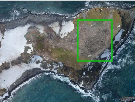
The Polish-Norwegian team did 8 flights with a total distance of about 1500 km, in the time frame from 11 Nov to 6 Dec 2014. The image data was captured from an altitude of 350 - 400 meters above sea level and covered the coast lines and hatching areas along the coasts of King George Island. The ground resolution for the visible camera was approximately 5 cm (Figure 5) and infrared camera 40 cm .
Figure 5. The image of ASPA 151 penguin colony (selected polygon framed in green), an example of results.
Figure 6. Adélie penguin breeding groups selected for
comparison of manual and automatic estimation (ArcMap 10.1).
The imagery was taken with sufficient overlap to create orthorectified image mosaics as well as 3D models of the images using Agisoft Photoscan software. Images of this GSD
allowed to locate and estimate the number of nests of Adélie,
Figure 7. The polygon of the selected penguin group and result of automatic estimation of the objects.
Figure 8. The result of automatic estimation of the counts of objects (penguins) (Image J).
In the next breeding season the extension of the research area and reaching out to the colonies that have so far not been accessible from the ground is planned. The use of UAV for purpose of CEMP monitoring, will considerably facilitate the
process, reducing time and increasing the level of observer’s
safety.
ACKNOWLEDGEMENTS
The research leading to these results has received funding from the Polish-Norwegian Research Programme operated by the National Centre for Research and Development under the Norwegian Financial Mechanism 2009-2014 in the frame of Project Contract No 197810.
REFERENCES
CEMP standard methods, 2014. http://www.ccamlr.org-/en/system/files/CEMP%20Standard%20Methods%20Jun%202 014.pdf
Chwedorzewska, K.J. and Korczak M. 2010. Human impact upon the environment in the vicinity of Arctowski Station, King
34th Symposium of the European-Association-of Remote-Sensing-Laboratories (EARSeL), Warsaw, Poland.
Korczak-Abshire, M., Węgrzyn M., Angiel P. and Lisowska M. 2013. Pygoscelid penguins breeding distribution and population trends at Lions Rump rookery, King George Island. Polish Polar Research, 34 (1), pp. 87-99.
Korczak-Abshire, M., Zmarz, A., Chwedorzewska, K.J., Karlsen, S.R., Rodzewicz, M., Storvold, R., Goraj, Z., 2014. UAV for monitoring of indicator species on Antarctic protected areas. In: 34th Symposium of the European-Association-of Remote-Sensing-Laboratories (EARSeL), Warsaw, Poland.
Solbø, S. and Storvold, R., 2013. The CryoWing unmanned
aerial system for scientific measurements. In: First Conference of the International Society for Atmospheric Research using Remotelypiloted Aircraft, ISARRA, Palma de Mallorca, Spain.
Xsens Technologies B.V., 2013. http://www.xsens.-com/en/general/mti-g.
![EFEK ANTIFUNGI EKSTRAK ETANOL DAUN RUMPUT MUTIARA (Hedyotis corymbosa [L.] Lamk) TERHADAP PERTUMBUHAN Candida albicans SECARA IN VITRO.](data:image/gif;base64,R0lGODlhAQABAIAAAP///wAAACH5BAEAAAAALAAAAAABAAEAAAICRAEAOw==)