EVOLVING TECHNIQUES OF DOCUMENTATION OF A WORLD HERITAGE SITE IN
LAHORE
R. Arif, K. Essa
Aga Khan Cultural Service Pakistan, House 7/10, White House Lane-1, Sundardas Road, Zaman Park, Lahore, 54000, Pakistan - [email protected], [email protected]
KEY WORDS: 3D - laser scanning, EDM documentation, world heritage site, cultural heritage, photo rectification, conservation, urban heritage, Lahore Fort.
ABSTRACT:
Lahore is an ancient, culturally rich city amidst which are embedded two world heritage sites. The state of historic preservation in the country is impoverished with a dearth of training and poor documentation skills, thus these monuments are decaying and in dire need of attention. The Aga Khan Cultural Service - Pakistan is one of the first working in heritage conservation in the country. AKCSP is currently subjecting the UNESCO World Heritage site of the Mughal era Lahore Fort to an intensive and multi-faceted architectural documentation process. This is presented here as a case study to chart the evolution of documentation techniques and enunciate the spectrum of challenges faced in the documentation of an intricate Mughal heritage site for conservation in the Pakistani context. 3D - laser scanning is used for the purpose of heritage conservation for the first time, and since has been utilised on heritage buildings and urban fabric in ongoing projects. These include Lahore Fort, Walled city of Lahore as well as the Baltit Fort, a project restored in the past, assisting in the maintenance of conserved buildings. The documentation team is currently discovering the full potential of this technology especially its use in heritage conservation simultaneously overcoming challenges faced. Moreover negotiating solutions to auto-generate 2D architectural drawings from the 3D pointcloud output. The historic architecture is juxtaposed with contemporary technology in a region where such a combination is rarely found. The goal is to continually develop the documentation methodologies whilst investigating other technologies in the future.
1. INTRODUCTION AND CONTEXT
Lahore, a culturally rich kaleidoscope of history and culture, is a city whose origins date back to antiquity. Layered with the remains and monuments of consequent diverse civilisations, this ancient city is studded with heritage sites of significant universal value amongst which are embedded two UNESCO World Heritage sites. One of which is the Lahore Fort, an ancient fortress that has been the nucleus of the historical city of Lahore for centuries. The slowly decaying monuments have long been neglected since the state of historic preservation in the country is impoverished, with a dearth of proper training and education and poor documentation skills. The current situation of Pakistan as a developing country, the access to basic resources and education is still lacking therefore the funds and resources available to restore the heritage of the nation are non-existent. However as this heritage is an inseparable part of this country and the historic identity of the world any conservation effort is a necessity.
The Lahore Fort is a palimpsest of historically vital architectural elements forming a royal complex of heritage monuments. One of the most significant ancient citadels, it forms a prime example of the Mughal building style of architecture involving advanced techniques of detail and artisanship. The Fort was declared a UNESCO World Heritage Site in 1981, primarily due to its possession of the world’s largest mural wall referred to as The Picture Wall.
Built as an ancient mud fortress, it has subsequently been destroyed and re-built by multiple succeeding reigns. The existing base structure has been re-fortified as the brick fort we see today by the Mughal emperor Akbar. A majority of the 21 monuments, still surviving today in the 20 hectares of a fortified space, were also built in the Mughal era. Possessing monuments embellished in exquisite decorative surfaces of Mughal
craftsmanship it represents the epitome of the Mughal art, architecture and engineering feats. Regrettably very few conservation efforts to date have been made in this world heritage site. A large number of monuments remain undocumented, with no previous drawings or records and several ones are in an endangered state, in urgent need of conservation and in danger of imminent collapse.
Figure 1. Drone image of The Lahore Fort
Beginning in 1992, the AKCS-P began by conserving ancient vernacular heritage sites in mountainous Hunza and Skardu in the far north of the country, where sites like the Baltit Fort, Karimabad settlement, Altit Fort, Shigar and Khaplu palaces have been rehabilitated and have won UNESCO awards for excellence. Since 2007 it has been working on the historic Walled City of Lahore including the urban fabric of this historic core, the Royal Baths (Shahi Hamam), the Wazir Khan Mosque and its public square (1634 CE).
AKCSP is currently subjecting the UNESCO World Heritage site of the Mughal era Lahore Fort to an intensive and multi-faceted architectural documentation process. This is presented here as a case study to enunciate the spectrum of challenges faced in the documentation of a world heritage site for conservation in the Pakistani context. This project portrays how an intricate Mughal monumental complex is documented from the macro perspective right down to its finest micro details, by evolving documentation techniques from survey machines like the total station to the introduction of contemporary technology of 3D - laser scanning. Ultimately the digital documentation of the Lahore Fort will be the first step in conservation of the many monuments within this large area.
2. EXSISTING DOCUMENTATION TECHNIQUES UTILISED AND DRAWBACKS
The Lahore Fort in all its entirety will take several decades to conserve. The AKCS-P has currently picked the most crucial monuments with greatest universal and historical value and created projects divided into various phases to be completed in fixed timeslots. The first of the monuments to be documented was the Western façade of the Picture Wall. This was carried out in a period of nine months under a project called the Picture Wall Documentation, Presentation and Promotion Project. Financially aided by the Royal Norwegian Embassy and the AKTC, and carried out in collaboration with the Walled City of Lahore Authority.
At the centre of this documentation process is the 1450 feet long (and 50 feet high) Picture Wall, a fortified apron wall richly decorated on the exterior by glazed tile kashikari mosaics (and various forms of fresco work) with elaborate natural motifs and figurative themes depicting 16th century life at the Mughal court. The Picture Wall also happens to be the longest mural wall in the world, and is one of the main reasons for the Fort achieving world heritage status. Within the documentation of this embellished wall numerous techniques and methods that have been long been used in conservation by the organisation were employed.
Figure 2. Glazed tile mural of the Picture Wall
The only prior documentation of this mural wall exists in a 1920 publication called Tile Mosaics of the Lahore Fort by a Dutch professor and superintendent called J.P Vogel. In this volume eighty colour plates of the original lithograph have been published and depict the state of deterioration at the time of documentation. These panels of the glazed tile mosaics were documented over a course of five years by native draftsmen, manually tracing out the panels on the façade. Which they later
prepared as final drawings on a reduced scale. The upper panels on the 50 feet façade could only be reached by the use of bamboo ladders and the execution of the task in the hot summer months, proved that this was a most arduous task. (J.P Vogel, 1920)
Figure 3. Plate. XI. Elephant Fight - Plate from Tile mosaic of the Lahore Fort by J.P Vogel
Almost ninety-six years later documentation methodologies utilised have upgraded to include the use of EDM (Electronic Distance Measuring) total stations. Simply explained the tracing is now done from the ground floor by a laser pointer emitted from a machine that a surveyor directs. This creates a scaled wireframe three-dimensional model that is easily edited in AutoCAD and utilised to extract sections and plans which will assist the conservation to formulate intervention proposals. The field data for this phase of the project has been gathered by two Leica TCR 805 Ultra with the software interface, AutoCAD and TheoLT as a plugin operating on a field laptop. This surveying was done by individuals recently trained by the AKCS-P that is a team including members of the local labour, taught the skill while assisting surveyors, and members of the Ciqam team, a women social enterprise in Hunza, that trains local women in the skills of surveying and carpentry. (Salman, 2009) Such an opportunity has allowed a deeper social impact to be created in the local sphere for marginalised individuals and unskilled labour.
Figure 4. EDM survey of the Picture Wall
Authority/Government of Punjab has allowed it to be possible.
Figure 5. Photo rectification of the Picture Wall
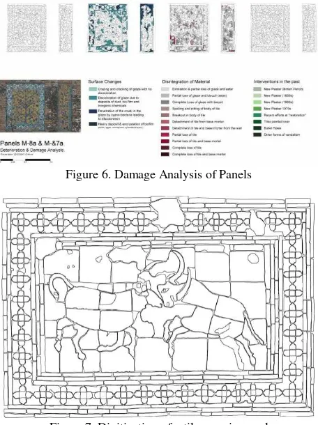
Furthermore by utilising the photo rectified image a team of architects worked to digitise each tile fragment on selected strips of the facade, chosen on the basis of containing the whole range of decorative elements and deterioration. Utilising this a damage atlas was created charting out each type of deterioration of the decorative surfaces on the historic façade. Finally creating a much needed record of the details of the mosaics and of their weathering and deterioration to better assist in the minute surface treatment and conservation proposals.
Figure 6. Damage Analysis of Panels
Figure 7. Digitization of a tile mosaic panel
Lastly to form a cohesive understanding of the monument in order to carry out a successful conservation, the documentation phase included analytical work to analyse the heritage building. This analysis consists of classification and analysis of
weathering forms, laboratory analyses of materials using SEM and X-ray diffraction, and investigations into the intense micro-biological and environmental aspects of the degradation of the monument. Additionally geo-technical analysis and investigative excavation pits were carried out to determine stratigraphy and foundation details, creating a structural stability analysis allowing for all aspects to be covered in the documentation. This detailed documentation and analysis formed the first and essential step in the conservation of the world-renown façade. The data compiled is currently being used to treat a selected section of the historic wall to eventually form a cycle of conservation for the whole length of the façade.
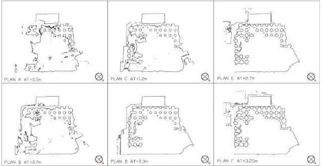
The next phase of documentation underway at the Lahore Fort is called the Digital Documentation of the Lahore Fort Project. This is divided into the three components, the digital documentation of prime monuments in the Lahore, the complete topographic survey of the Fort and its context and the documentation of the remaining Picture Wall. For this endeavour 5 Total stations have been put to use for the detailed topographic survey of the 20 hectares of the area of Lahore Fort and individual buildings within the Fort. This survey included never before documented below grade chambers built into the Picture Wall. These machines are being operated by groups of two surveyors, all members of the previously mentioned Ciqam team trained by the AKCS-P.
Figure 8. Wireframe model EDM survey of a monument in the Lahore Fort
Most of the aforementioned documentation techniques including the EDM (electronic distance measurement) total station instrument and ortho photo-rectification techniques have been introduced by the AKCSP into heritage documentation in Pakistan and have been utilised since quite some time, replacing laborious and often inaccurate manual methods used by local conservators and craftsman.(Salman,2009)
the total station records data in the form of polylines therefore the final product is obtained in the form of a wire-frame model. Additional surface details for intervention proposals have been collected using photo rectification. Although the technique utilised for photo rectification lends an image, it does not have three dimensional surface details but is two-dimensionally scaled. However combining these two processes have so far given enough information for the creation of conservation and intervention proposals.
In light of the advent of contemporary technology like 3D-laser scanning and its continuing widespread use in heritage documentation. The ability of 3D laser scanning to capture the three dimensional surface of a building in all its entirety with an accuracy less than a millimetre. Along with digitally preserving the building state incorporating its actual material textures and colours thus leading to the creation of an almost exact replica in the digital three-dimensional interface. Lends an incredible advantage as a historical record for posterity. The added benefit compared to other technologies in the drastic decrease in fieldwork and very high accuracy lends it a greater degree of advantage. Significantly since this is data that may not just be useful for the present generation but for the many generations to come, especially in the event of an unforeseen disaster. Simply put the building form has entered the digital memory.
With high regard to such benefits the AKCS-P with the financial assistance of the US Ambassadors Fund and Aga Trust for Culture has acquired a 3D-laser scanner to create a historical record documenting the various fragile monuments studding the UNESCO world heritage site area of the Lahore Fort for posterity.
3. INTIATION OF 3D - LASER SCANNING INTO THE CONTEXT
3.1 Background
3D - laser scanning is a technology that works by digitally capturing the three-dimensional surface of a physical object by projecting laser light and measuring the reflected pulses to create a highly accurate digital three dimensional representation in the form of pointclouds of data. Since long this technology is being used in a range of applications from industrial design, meteorology to crime scenes finally making its way to cultural heritage. The renowned organisation CyArk was founded in 2003 for the very mission to digitally preserve the world’s significant cultural heritage before they are lost. (CyArk, 2014) The case of Uganda’s historic Kasubi tombs depicts the incredible benefit of this endeavour. The complex was digitally preserved by CyArk a year before its tragic demise in a fire, providing the only lasting accurate digital record and potential blueprint for reconstruction. (Preston, 2011)The work they undertake is by utilising 3D scanners to capture pointcloud to create 3D models.
In 2015 the organisation signed a deal with a Pakistani academic research institute called LUMS and introduced the 3D laser scanner to Pakistan for the first time. A representative from the organisation was sent to train young professionals in a workshop that included employees of the AKCS-P. By 2016 the AKCS-P acquired a 3D laser scanner provided with the support of international donors, meant to be used in the practical implementation of heritage conservation for the first time in the country. A Leica ScanStation P-40 terrestrial scanner was acquired from Leica Geosystems Singapore. After which a
Leica trainer was sent from Singapore to conduct a week long workshop to train all the employees of the AKCS-P.
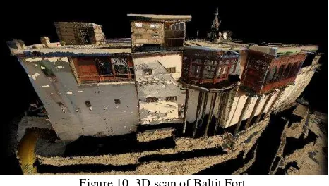
Since then it has been used to create a record of heritage buildings and urban fabric in ongoing projects. Specifically the world heritage site of Lahore Fort, historic public squares and neighbourhoods of the Walled City of Lahore for a master conservation plan project, while also creating point cloud records of projects that have been restored by AKCS-P in the past, assisting in the maintenance and upkeep of the conserved building/s. These include the 1000 year old vernacular Baltit fort in Hunza, in the mountainous north of the country.
3.2 Application onto context
To start with, the Western façade of the Picture Wall at the Lahore Fort, was scanned as the first test project. Within this project, scans were taken at a ten feet distance between stations and tried out at resolutions of 6.3mm at 10m and 3.1mm at 10m. This exercise amongst various things taught us what the possible range of the scanner could be, allowing us to apply and practice different registration techniques and create a comparison of the results of different resolutions and distances between the stations. Finding the ideal combination as per the case study.
Figure 9. 3D scan of Picture Wall
3.2.2 Laser-scanning a vernacular heritage monument Notably the first proper building documented by the 3D - laser scanner happened to be the vernacular ancient heritage site called the Baltit Fort situated in Hunza. This project from its inception to completion formed the cycle of desired workflow to be created for the laser scanner. This accretion of narrow houses is archetypical of local domestic architecture. The Fort occupying around 1,000 Sq. m of space is built on top a natural amphitheatre i.e. a very steep terraced hill. The situation of being situated at a great height with surrounding narrow terraces, and the inaccessible underground spaces only accessed by small sized vertical openings and on top of that the time constraints proved to be quite the challenge.
Figure 10. 3D scan of Baltit Fort
190 scans were taken across a time of 12 days on a 3.1 mm at 10 m resolution for the interior spaces and 1.6 mm at 10 m for exterior elevations including the capture of around over a 1000 photographs. Simultaneously a team of the aforementioned Ciqam team, local young surveyors experienced in EDM total station were initiated and trained into the techniques of 3D - laser scanning. Disseminating this knowledge and skills amongst the next generation of surveyors. Allowing new future opportunities for these young workers and a greater exposure of the technology in the country.
Figure 11. Demonstration of 3D laser scanning to members of the Ciqam team in Baltit Fort
3.2.3 Laser-scanning a historic urban area
Meanwhile a project of urban scale was undertaken, in the case of a master conservation redevelopment plan being established for the historic walled city of Lahore. 3D - laser scanning was conducted on three urban spaces in notable neighbourhoods in the dense historic walled city along with the interconnected main streets and tributaries. The very narrow and congested winding streets with various balconies and traditional architectural projections and the congested, high frequency of urban movement created difficulties in scanning the spaces. 100 scan stations were taken in the dense urban environment with a resolution of 6.3 mm at 10 m resolution.
This pointcloud data was then used to produce accurate elevational line drawings digitised manually by a team of architects tracing the pointcloud data given. The elevation
drawings were used to create intervention proposals to delineate acceptable laws of redevelopment for the heritage urban zone.
Figure 12. Elevation of urban area digitised through laser scan
3.2.4 Laser-scanning a world heritage site
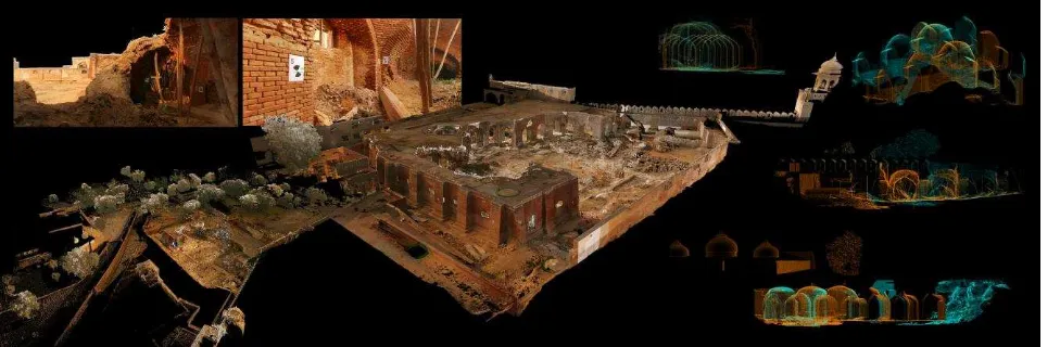
One of the first of the monuments of the Lahore Fort to be documented via the 3D laser scanner was the Royal Kitchens. This is a brick barrel vaulted structure built in the 16th century.
Due to neglect, abandonment and mis-use it has much deteriorated becoming an endangered structure, partly in ruin. The AKCS-P is part of an ongoing project to conserve and rehabilitate this endangered historic structure through adaptive re-use. For this purpose documentation of this building was required. The original geometric form has been reduced to an organic form by heavy erosion with intense weathering over time. Therefore it is difficult to trace the non-linear ruined details by survey equipment like the total station, it would require intense labour to take the many points thus in this case the 3D laser scanner could accomplish and capture details that no other documentation technique could.
The smaller open plan structure was laser scanned across a period of 6 days with 100 scans at the 3.1mm at 10m resolution. Around 600 fish-eye lens photographs were captured. The dataset was registered through a combination of visual alignment and target registration. This was yet another challenging task due to the mass rubble and debris on the ground, difficult to access areas due to collapsed roof and the necessity to capture all corners and parts of the crumbled building.
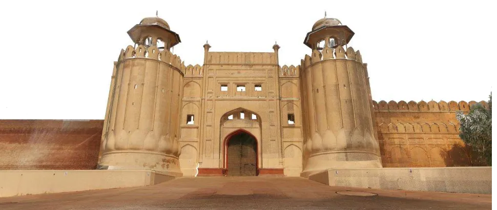
Moreover another notable monument 3d laser scanned in the Lahore Fort is the Alamgiri gate. Noteworthy for its heavily fluted bastions rising out of carved lotus buds, its form has lent it to become an iconic monument in the country, often Figure 13. Royal Kitchens 3D laser scanning
becoming the representational symbol for the Lahore Fort and the city of Lahore. The structure of the gate consists not just of its periphery bastion but a great number of arched and vaulted rooms constructed within the walls and connected by narrow arcades, creating multi-layered terraces. One of the rooms on the ground level also contains the ancient temple of Loh, known to be the Hindu deity on which the city of Lahore gets its name. The many hidden rooms provided an ideal vantage point for defensive purposes with arrow slits being the only opening to the exterior.
Each space had to be scanned separately connecting the scans through targets pasted on the narrow outer loggia. Lighting was also a major challenge as many of the interior rooms, basements and narrow stairwells were very dark with close to minimal natural light piercing through the arrow slits. Lack of electricity and electrical switchboards in this ancient building created many difficulties. Thus large battery torches and very long extensions connected to a switchboard far off were used to assure a proper illuminated result in images, with the material texture depicted properly. 200 scans were taken on a 3.1 mm at 10m resolution for this monument. The scans were registered using auto-alignment and remaining ungrouped stations by visual alignment. The 3D pointcloud model was geo-referenced using the total station readings of the targets applied on to the monument.
Subsequently quite a few monuments of this world heritage site have been scanned with a similar workflow. This process will continue till all of the most valuable monuments are documented. The current project being undertaken in the Lahore Fort at the time of writing this paper is the Summer Palace, a space consisting of massive subterranean chambers with intricate fresco details. The lack of light is another challenge being met. The scanned data will aid in an upcoming project of the AKCS-P for the conservation and adaptive re-use of this space to create a state-of the-art museum for the city.
Lastly another upcoming challenge for the laser scanning team is the documentation of a prime structure called the Sheesh Mahal. This is literally translated as the Palace of Mirrors since it is embellished with hundreds of fragments of mirrors. The
tracing out of these highly intricate details with the total station is almost impossible thus 3D-scanning would be more ideal. However the limitation of laser scanning for highly reflective surfaces presents a unique problem. The mirrors however are somewhat eroded and have lost their original reflectivity thus a test scan is to be tried out.
4. CHALLENGES AND PROCESSES:
CONTEMPORARY TECHNOLOGY IN A DEVELOPING COUNTRY
Besides the the valuable historical record a 3D laser-scanned documentation creates, one of the main requirements for heritage conservation especially at architectural organisations is to utilise the data for conservation in the form of architectural output such as 2D drawings in the form of sections and plans. In this respect AKCS-P is discovering the technology in this aspect for the first time in the country. The academic institution that previously carried out the technology utilised the information by creating virtual tours and interactive animations. Both workshops conducted provided training in all the primary laser scanning techniques however the advice on utilisation of outputs were directed towards outputs such as virtual animations and the knowledge of producing architectural outputs from the data obtained still remained to be known.
The 3D laser-scanning documentation team therefore is currently discovering the full potential of laser scanning technology in the architectural aspect. In the Master Conservation Rehabilitation Plan project, architectural drawings were obtained by manually tracing the pointcloud, this however was a laborious and time-consuming process. The dispersion of points in the pointcloud also make it somewhat difficult to decipher the edges of a surface and thus to digitise using this data.
the 3D pointcloud were discovered. There appear to be various softwares to convert the pointcloud into a 3D model mesh however for deriving auto-generated editable sections and plans in AutoCAD from the vector models the options seemed scarce. After many trials one such option seemed successful. A software called Pointfuse was acquired. Within this software the pointcloud was generated into a vector model by fusing the points together to form planar surfaces. The software then allows for the slicing of sections and plans inherently and an export into AutoCAD in polylines that are scaled and editable. This allows for instantaneous auto-generated plans and sections from wherever one chooses in the model extinguishing the need of extra labour and digitisation and time spent.
This was utilised on the Royal Kitchens file to generate sections and plans. A major hurdle encountered was that the pts file generated was too large to be processed entirely by the systems available. For the data to be in a form to be utilised it requires heavy processing. A solution for this was that smaller sliced sections of the data were processed to produce sectional information. Further investigation into this process is being done, if streamlined and refined it could allow for incredibly fast and easy documentation and data acquisition, with infinite amount of sections and plans possible to be cut instantly once 3D model is created.
Figure 14. Auto-generated plans from 3D scan pointcloud
Another challenge is that the scanner produces very large data sets. This created an issue of data storage at our firm. The servers available are quite large in comparison to most in the country but still not enough for the rate and size of data produced by the 3D laser scanner. Cloud storage solutions were negotiated but even those require a fast internet uploading speed which is rare in a developing country with frequent power outages.
Thus the realisation is that to utilise such advanced technology and the acquiring of such in a developing country, suitable powerful systems and tools as well as networks are also required to handle the data. Regardless it is still a huge achievement to be able to digitally preserve a UNESCO world heritage site in a country like Pakistan with such contemporary technology like 3D laser-scanning. This is not just the nations own heritage but of significant universal value therefore valuable heritage of the world.
Currently underway is the utilisation of the scanned data of the Baltit Fort by an external international consultant Singaporean firm employed to investigate the structural stability of the building. In an earthquake in 2015 the structure was greatly damaged and over the years a visual tilt has been observed. The firm will utilise the recent scanned data to create a 4 Dimensional study by adding the dimension of time over which
the building transforms to find the structural displacement of the building.
The use of photogrammetry was also considered yet the realisation was made that since our requirement is a highly detailed architectural output that includes all the building internal micro features the terrestrial 3D - scanner may be more suitable as it has the ability to capture in greater detail. However often the roof of the buildings are inaccessible and there are certain buildings that have greater detail on the top portions for those particular cases a drone is required to capture details that can only best be captured from an aerial position. Therefore a combination of the two technologies would be ideal for the highest quality output. Since we recently acquired a drone, the integration of these technologies is going to be executed. After all the experience gained in a few months, measures are being taken to solve the encountered issues. Including international exposure to firms with good experience in utilising 3D laser-scanning for architectural outputs. Negotiations with an academic institute that possesses a super computer to store the big data created. The procurement of suitable systems powerful enough to handle the data. The AKCS-P being an international organisation continues to follow international standards and practices as well as investing in the latest technology to allow the country to be at par with the world.
5. CONCLUSION
From the months of manual tracing of panels on the Picture Wall by native draftsmen perched on bamboo ladders in the scorching Indian summer, to the weeks of digitally tracing building facades utilising EDM total stations and to the days of three-dimensional capturing of buildings in their entirety by a 3D laser scanner. We can chart the evolution of documentation techniques, the world heritage site of Lahore Fort has been subject to.
With all the drawbacks, advantages and comparisons of all techniques, a combination of the old and the new would perhaps best provide an adequate record on which to create a successful conservation plan. This ancient heritage need be preserved whilst constantly looking to and gaining aid from updates in technologies to assist such causes.
CEO Salman Beg for his encouragement to participate in such an endeavour and continued support at the AKCS-P for all of this to be possible.
REFERENCES
AKF, 2016. http://www.akdn.org/our-agencies/aga-khan-trust-culture
Arithmetica Ltd, Pointfuse. 2017, http://pointfuse.com/
CyArk & Partners, 2014. http://www.cyark.org/about/
Hashmi, A., 2016. LUMS and the Digital Preservation of Pakistan's Heritage.
http://www.cyark.org/news/-lums-and-the-digital-preservation-of-pakistans-heritage
Koch, E., (1991). Mughal Architecture: An Outline of Its History and Development, 1526-1858. Prestel. ISBN 3-7913-1070-4
Latif, S., 1892. Lahore: Its History, Architectural Remains and Antiquities: With an Account of Its Modern Institutions, Inhabitants, Their Trade, Customs, &c. New Imperial Press, London, Oxford University.
Muhammad, S., Introducing EDM survey for recording vernacular heritage and sites in Pakistan. In: 22nd CIPA Symposium, October 11-15, 2009, Kyoto, Japan
Preston, E., 2011. "The Big Idea - Laser Preservation". National Geographic Magazine. Retrieved 2014-10-11.
Ruggles, F., 2011. Islamic Gardens and Landscapes. University of Pennsylvania Press. ISBN 9780812207286.
Tan, L., Baltit Fort, Karimabad, Pakistan Restoration and Adaptive Re-use.
http://web.mit.edu/akpia/www/AKPsite/4.239/baltit/baltit.html