AND PROCEDURES FOR ARCHITECTURAL HERITAGE IN IRELAND
M Murphy a, A Corns b, J Cahill c , K Eliashvili d, A Chenau d, C Pybus f, R Shaw b, G Devlin b, A Deevy b L Truong-Hong e a VBE Lab Ireland, [email protected]
b Discovery Programme Ireland, [email protected] c
Office of Public Works, [email protected] d
Dublin Institute of Technology, [email protected] e
University College Dublin, [email protected] f
Carleton University, [email protected]
Commission II, WG VI/4
KEY WORDS: HBIM, Digital Heritage Documentation, Laser Scanning, Photogrammetry, Heritage Management
ABSTRACT:
Cultural heritage researchers have recently begun applying Building Information Modelling (BIM) to historic buildings. The model is comprised of intelligent objects with semantic attributes which represent the elements of a building structure and are organised within a 3D virtual environment. Case studies in Ireland are used to test and develop the suitable systems for (a) data capture/digital surveying/processing (b) developing library of architectural components and (c) mapping these architectural components onto the laser scan or digital survey to relate the intelligent virtual representation of a historic structure (HBIM). While BIM platforms have the potential to create a virtual and intelligent representation of a building, its full exploitation and use is restricted to narrow set of expert users with access to costly hardware, software and skills. The testing of open BIM approaches in particular IFCs and the use of game engine platforms is a fundamental component for developing much wider dissemination. The semantically enriched model can be transferred into a WEB based game engine platform.
1. INTRODUCTION
1.1 Overview
As a multi-disciplinary and evolving system, Historic Building Information Modelling (HBIM) consists of the survey of existing structures using remote sensing followed by the mapping of parametric and information rich objects onto a geometric framework based on the remote survey data. The parametric objects which represent the architectural elements are graphically constructed or coded and are based on historic architectural documents (architectural rules and shape grammars). The resultant HBIM can then be used for automatically producing conservation documentation and analysis of historic structures in addition to visualisation.
This paper addresses a series of questions to identify and develop Historic Building Information Modelling Guidelines and Procedures for Architectural Heritage in Ireland.
1. What are the prototypical standards for data capture based on laser scanning and digital photogrammetry for digital recording of historic structures and environments; 2. What additional processing is required to produce
suitable documentation to assist the conservation process 3. How can Historic Building Information Modelling
(HBIM) ameliorate the digital conservation documentation dilemma, if it is an interpretive digital representation
4. Can a combination of laser/photogrammetric survey data and HBIM (producing orthographic drawings and
schedules) satisfy the requirements for the conservation documentation process
5. Do WEB based, Game Engine and VR Platforms have potential to disseminate at appropriate costs the required conservation documentation based on HBIM to conservation experts
1.2 Current Research
Adding Intelligence
Building Information Modelling (BIM) is a virtual representation of a building, its structure, materials, and environment, providing the associated information (the
“metadata”) related to its design, construction and future
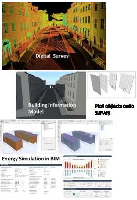
lifecycle. The intelligent data or information contained in the model can range from geometric and spatial to material, structural, environmental, cultural and economic. The model is comprised of intelligent objects which represent the elements of a building structure and are organised within a 3D virtual environment. Historic Building Information Modelling (HBIM) is an extension of BIM for the physical and knowledge management and conservation of architectural heritage. HBIM involves the digital recording of historical buildings using remote sensing (laser scanning, digital photogrammetry) or combinations of digital surveying and manual techniques. The acquired survey data is then processed improving the data organisation and adding intelligence using BIM software platforms. Because of the difficulties in accurately representing the variety of complex and irregular objects occurring in historic buildings existing BIM libraries of parametric objects need to be rebuilt and coded. In addition as the building exists and is represented by a remotely sensed model, systems to map the intelligent library objects onto digital or other survey data were also developed (Fai et al. 2011; Murphy, McGovern & Pavia 2009; Dore & Murphy 2014).
Figure 1: Scan to HBIM to Documentation (Dore & Murphy 2014)
Cultural heritage researchers have recently begun applying Building Information Modelling (BIM) to historic buildings. The intelligent data or information contained in the model can range from geometric and spatial to material, structural,
environmental, cultural and economic. The model is comprised of intelligent objects with semantic attributes (Su, Y and Jurie, F, 2012) which represent the elements of a building structure and are organised within a 3D virtual environment (Eastman et al, 2011). The idea of creating extensions of BIM more adapted to existing and historic buildings originated with the case studies of the researchers (Chevrier et al 2010) and De Luca (2011) that developed the concept of positioning parametric 3D CAD objects, comprising of architectural primitives, in the point cloud data. The benefit of using parametric objects was their ability to change geometry according to the altered dimensions of the parameters and to fit the historic structures as closely as possible. While the term HBIM was coined in Dublin Institute of Technology and Trinity College Dublin, many academic researchers became interested in the field and HBIM is now a broad area of research. Most of the research carried out in past few years was case study-based and was initiated by educational institution in different countries such as Carleton University in Canada (Fai et al. 2011; 2013; 2014), Polytechnic of Milan in Italy (Oreni et al. 2014), University of Leuven in Belgium (Boeykens 2011; Boeykens, Himpe & Martens 2012) and others (Baik et al. 2014; Wu et al. 2013). The methodology used by these researchers to develop HBIM involved data collection using laser scanning and modelling historic architectural elements graphically using BIM software platforms (Figure 1) followed by mapping 3D objects in the point cloud data.
The automatic generation of structured building information models from point clouds is a primary focus for a lot of research in this area. Jung et al. (2014), Xiong et al. (2013) and Zhang & Zakhor (2014) have shown promising results for automatic object recognition and feature extraction from point cloud data. Although progress has been made in this area, results are currently limited to automatic extraction of basic elements such as planes and openings. Automatic extraction of complex architectural elements that occur in existing and historical buildings is still in its infancy. The results from existing automatic approaches include surface models, planes, 3D vectors or a subset of the original point cloud. All of these results still need to be converted into structured information enhanced and parametric building components which at present needs to be carried out manually (Volk et al., 2014).
A procedural modelling approach uses a sequence of generation instructions, rules or algorithms that can be repeated with varying characteristics to automatically generate 3D geometries (Kelly & Mccabe, 2006, Muller et al., 2006, Hohmann et al., 2009 and Thaller et al., 2011). While procedural modelling has many advantages such as automatic generation of geometry, great flexibility for variation and object hierarchy a disadvantage of these methods for existing buildings is that they lack the detail and accuracy required for many applications in AEC or heritage sectors. Current software for procedural modelling also does not automate the production of engineering drawings and is primarily used for applications such as visualisation.
HBIM Workshop and Software Survey
Prior to organising a two day HBIM workshop in Dublin (Unpublished DIT 2016) a questionnaire was sent to specialists projects involved in Historic BIM to identify different approaches and software platforms they used. These included the Dublin Institute of Technology, Discovery Programme, Office of Public Works in Ireland, Historic Environment Scotland, Historic England, Polytechnic of Milan and Carleton
HBIM was measured; data collection techniques, laser scanning, photogrammetry and other methods – software for survey processing - Parametric CAD, BIM and other software options. When asked to identify the different software systems used in their HBIM workflow, the following figure contains their responses.
Figure 2: Software used in HBIM workflow
When asked what systems did they use in developing libraries of reusable parametric objects representing historic architectural elements and rules, graphically built in Revit was the approach used by 50%, others used coding in GDL and Grasshopper in Rhino. One of the participants added the use of a manual methodology for geometric modelling using computer aided architectural design (CAD) methods. For systems mapping theses library objects onto remotely sensed survey data most used manual methods in Revit or ArchiCAD. One respondent identified using Cloud Compare and Faro Scene for automatically detecting planes to assist with plotting/creating objects and then procedurally modelling with GDL to semi-automatically plot library objects to survey data.
2.PROTOTYPICAL STANDARDS FOR DATA CAPTURE - LASER SCANNING AND DIGITAL
PHOTOGRAMMETRY
2.1 Data Capture
The terrestrial laser scanner is a device that automatically measures the three-dimensional co-ordinates of a given region
of an object’s surface, in a systematic pattern at a high capture
rate in near real time. The laser ranger is directed towards an object by reflective surfaces that are encoded so that their angular orientation can be determined for each range measurement.
Figure 3: Time of Flight Scanner
The entire instrument and/or the recorded object are rotated to achieve, where possible, complete 3D point coverage. Time of flight scanners calculate range, or distance, from the time taken for a laser pulse to travel from its source to an object and be reflected back to a receiving detector.
Figure 4: Structured Light Scanner
The process of structured light scanning involves projecting a known light pattern onto the subject. The light patterns will deform in relation to the surface of the object. These deformations in light will then be picked up by two cameras placed each side of the light projector. The images from the camera will then be sent onto a computer where software will process these deformations and create a 3D model.
The output from the laser scan survey described as a point cloud, this represents the x, y, z coordinates of a scanned object, and typically requires cleaning, sorting and combining of different sets of point cloud data before processing takes place.
Figure 5: Point Cloud from Time of Flight Scanner
Figure 6: Higher Resolution Point Cloud from Structured Light Scanner
Digital Photogrammetry
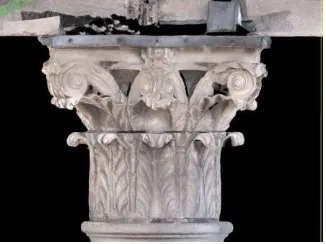
Microsoft Photosynth, Micmac, Pix4D, etc. Geo-referencing Image-based approaches are gaining momentum because they are much more cost effective than laser-based or structured light scanning methods. In digital photogrammetry stereo images are captured with multiple camera positions, pixel matching is used to locate similar points on the images and ray tracing to locate the camera positions. The geometric calculation of intersecting rays of light and the base line distance between cameras provides sets of triangles. From the triangulation process a point cloud is produced, locating the xyz points of the object. The point cloud is processed similar to laser scanning by meshing and texturing. The triangulation principle or bundle adjustments coordinates of multiple points on the object are measured in different images and are simultaneously used to calculate the 3D object coordinates by predicting the intersecting rays (Remondino et al. 2006;2011). The camera positions and the resultant 3D photogrammetric model of a Corinthian Capital is illustrated on the right hand side of the figure below.
Figure 7: 3D photogrammetric model of Gallarus Oratory
2.2 Pre-processing
The initial pre-processing stage involves cleaning and removing erroneous data or artefacts such as reflections of the scan through objects. These incorrect points can be eliminated before point clouds are registered. Once identified, reflections from objects in the background and in the space between the scanner and object e.g. trees and other objects in the foreground, moving persons or traffic and atmospheric effects such as dust or rain, can be largely removed by the introduction of range limits, or with the aid of graphical tools in a CAD software programme. Inaccurate points originating from multiple reflections can also be largely eliminated with this latter method. The point density on the object’s surface can vary significantly due to the altering range to the object surfaces during acquisition. Re-sampling, by reducing the density of the data for overly dense point clouds, can reduce the amount of unnecessary data and file size. Software platforms, based on the organisation of all available data in an octree structure (which is a data structure useful for visibility of 3D data) enables the sorting of the data into an even point density on the scanned surface of the object. Signal noise can be eliminated, if the object is known to be smooth, by the application of a low pass
or median filter. Filtering of point cloud data should be avoided where an object consists of smooth parts and edges as it will influence all object parts in a similar way.
Point cloud registration
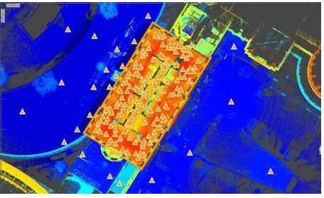
Registration is the combination of two or more point clouds taken from different observation points or the referencing of the scanned object in a global or project coordinate system. This is achieved using tie and control points that are either features of the object (e.g. corners) or special targets (spheres, flat targets with high reflectivity), which are identifiable in the point, cloud at the processing stage. Software for registering point clouds usually facilitates registration by special targets or by overlapping point clouds or a combination of. In the case of large structures where the placing of targets is not always possible, known features on the object are used to fully transform and align the scans. GPS systems can determine the co-ordinates of the laser scanner position which can then allow for the scans from each position to be brought into a common frame of reference in a global or project co-ordinate system. Alternatively registration by cloud matching is carried out by selecting a pair of partially overlapping scans and transforming one scan into alignment with the other using appropriate algorithms.
Figure 8: Point Cloud Registration
2.3 Data processing
The range data in the form of the point cloud from the laser scanner can be considered as a skeletal framework for recording the geometry of the historic structure. This geometric framework is then mapped with the associated image data
allowing for more precise identification of the structure’s
Figure 9: Point Cloud to Triangulation to Surface
Ortho-image
The creation of an ortho-image from point cloud data allows for all of the image and geometric data to be exported for visualisation or further processing in CAD, or other modelling platforms. Ortho-images are photo realistic models containing width, breath and height of an object. The ortho-image represents the data for a particular plane on the x, y, and z-axis; this can therefore represent elevation, plan, or section of an object. The texture for the ortho-image is taken from the associated image data, the 3D geometry is supplied from the meshed point cloud. Both sets of data are for a particular segment and plane within the point cloud. Initially planes are created on the x-y, x-z and y-z axis.
Figure 10: Ortho Image of Corinthian Capital
3.HISTORIC BUILDING INFORMATION MODELLING (HBIM) - DIGITAL CONSERVATION
DOCUMENTATION
3.1 Architectural Libraries
As previously stated, Historic Building Information Modelling (HBIM) incorporates a library of parametric objects, based on historic architectural data, and a mapping system for plotting the library objects onto laser scan survey data. BIM authoring platforms are mostly tailored for the modern architecture and their libraries of parametric objects are limited to basic components. To overcome this problem a design for a plug-in for BIM for complex architectural elements characterising existing and historical buildings was introduced by Murphy et al. (2013). A coding approach was applied for the design for
parametric objects based on architectural rules from pattern books and shape grammars.
The library elements (including detail behind the object’s surface) are accurately mapped onto a survey produced from laser scanning that represents the geometry and fabric of the building. The architectural elements can be coded or graphically produced. The design and detail for the parametric objects are based on architectural manuscripts ranging from Palladio to the architectural pattern books of the 18th century. The architecture of the Renaissance and the detail in architectural pattern books introduced and documented advanced scientific rules for the production of architectural elements, and these rules assist the design of parametric models. The use of historic data introduces
the opportunity to develop the details behind the object’s
surface concerning its methods of construction and material makeup.
Figure 11: Parametric Library Objects built from Pattern Books, Shape Grammars in GDL (Murphy, McGovern & Pavia 2013).
3.2 Mapping or Placing the Library Objects onto Scan Data
Figure 12: Mapping Library Objects onto point clouds
Manual Methods
within existing software platforms and a newly designed web-based ortho-image scaling application. The objects can be placed manually onto the point cloud/scan data and adjusted within ortho-projections for correct angular orientation Other applications can be used for extracting measurements from ortho-image and segmented point cloud data to size and place the objects. The figure below shows top left the automatic extraction of façade openings and dimensions to create the façade in the bottom of the figure. The door case is mapped from a segmented point cloud (left side of image) where the detail is more complex.
3.3 Procedural Modelling Semi-Automatic mapping from laser scan surveys
A procedural modelling approach uses a sequence of generation instructions, rules or algorithms that can be repeated with varying characteristics to automatically generate 3D geometries (Kelly & Mccabe, 2006, Muller et al., 2006, Hohmann et al., 2009 and Thaller et al., 2011). While procedural modelling has many advantages such as automatic generation of geometry, great flexibility for variation and object hierarchy a disadvantage of these methods for existing buildings is that they lack the detail and accuracy required for many applications in AEC or heritage sectors. Current software for procedural modelling also does not automate the production of engineering drawings and is primarily used for applications such as visualisation. In the work of Dore and Murphy (2014) design and conceptual framework for the HBIM procedural rules are based on concepts from shape grammars. A shape grammar is a production system used in procedural modelling to automatically generate two or three dimensional geometries from a basic vocabulary of shapes and a set of production or shape rules. The HBIM library of parametric architectural elements (Murphy etal, 2013) is used as a source for shape vocabulary on which the rules and algorithms are applied. Architectural rules and proportions are also used to assist the reconstruction process. Architectural rules and proportions outlined in pattern books relating to classical buildings are used to provide an initial estimate for the position and size of building elements on a generated building. This greatly reduces the amount of further editing required when modelling classical buildings from survey data.
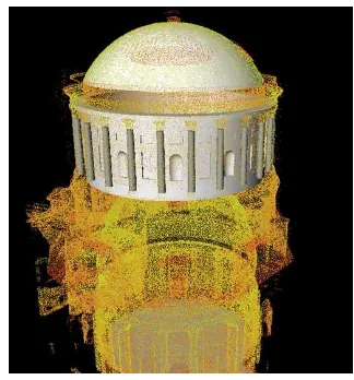
In the figure below the result of the application of procedural rules designed for accurate and efficient modelling of curved walls that contain deformation is illustrated. As a result of deformation the walls which support the dome may not be perfectly vertical and may contain different levels of deviation at different heights and locations. Horizontal cut sections through a circular wall at different heights capture areas where the wall is bulging or warping.
Figure 13: Procedurally Modelled Dome and Drum (Dore & Murphy 2014)
Creating a surface from cut sections through the wall at different heights allows the variances of the surface to be accurately represented. This new procedural rule allows users to select a group of horizontal cut sections which are then used to automatically generate the irregular wall surface. The non-vertical wall is created by generating a surface between each horizontal cut section. This rule results in automatically generated geometry for a drum wall which represents the true condition of the wall with deformation based on scan data.
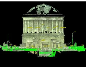
4.COMBINING LASER/PHOTOGRAMMETRIC
SURVEY DATA AND HBIM FOR CONSERVATION DOCUMENTATION
Figure 14: Conservation Documentation Dublin Four Courts based on HBIM and Laser Scanning
5.HBIM – DISSEMINATION – OPEN HBIM
While BIM platforms have the potential to create a virtual and intelligent representation of a building, its full exploitation and use is restricted to narrow set of expert users with access to costly hardware, software and skills. The testing of open BIM approaches in particular IFCs and the use of game engine platforms is a fundamental component for developing much wider dissemination. OpenBIM is a universal approach for collaborative design, realisation, and operation of buildings based on the open standards and workflows (Graphisoft 2016). IFC provides a series of definitions for all object element types used in the building industry and a text-based structure for storing those definitions in a data file (Solibri 2016).
WEB based, Game Engine and VR Platforms have potential to disseminate at appropriate costs the required conservation documentation based on HBIM to conservation experts. The proposed design in the final figure below combines Historic Building Information Modelling (BIM) with Game Engine tools and technologies as an active repository of associated knowledge and data.
Figure 15: Architecture for HBIM to Game Engine
Semantic WEB is employed to extract information and to relate digital content. The semantically enriched model can be
enables not only interaction with the virtual building but allows users to access and query related information rich data contained in the model and externally. The user access and queries are linked to the geo-location of elements of the building and to geometry shape and attributed semantics facilitated by data flow between the game engine asset server and the 3D HBIM components server.
6. REFERENCES
Baik, A, Alitany, A, Boehm, J & Robson, S 2014, 'JEDDAH HISTORICAL BUILDING INFORMATION MODELING "JHBIM"- OBJECT LIBRARY ', ISPRS Annals of the Photogrammetry, Remote Sensing and Spatial Information Sciences, vol. II-5, pp. 41-7 .
Boeykens, S 2011, 'Using 3D Design software, BIM and game engines for architectural historical reconstruction', paper presented to the CAAD Futures .
Boeykens, S, Himpe, C & Martens, B 2012, 'A Case Study of Using BIM in Historical Reconstruction - The Vinohrady synagogue in Prague', paper presented to The 30th International Conference on Education and research in Computing Aided Architectural Design in Europe
Brumana, R, Oreni, D, Raimondi, A, Georgopoulos, A & Bregianni, A 2013, 'HBIM for Documentation, Dissemination and Management of Built Heritage. The Case Study of St. Maria in Scaria d'Intelvi', paper presented to International Journal of Heritage in the Digital Era .
Carbonari, G, Stravoravdis, S & Gausden, C 2015, 'Building information model implementation for existing buildings for facilities management: a framework and two case studies', WIT Transactions on The Built Environment .
Chevrier, C, Charbonneau, N, Grussenmeyer, P & Perrin, J-P 2010, 'Parametric Documenting of Built Heritage: 3D Virtual Reconstruction of Architectural Details', International Journal of Architectural Computing 8(2).
De Luca, L 2011, 'Methods, formalisms and tools for the semantic-based surveying and representation of architectural heritage', Applied Geomatics 6(1866).
Eastman, C, Teicholz, P, Sacks, R & Liston, K 2011, BIM Handbook: A Guide to Building Information Modeling for Owners, Managers, Designers, Engineers and Contractors, 2nd Edition, Wiley .
Fai, S, Graham, K, Todd Duckworth, Wood, N & Attar, R 2011, 'Building Information Modeling and Heritage Documentation', paper presented to CIPA 2011 Conference proceedings: XXIIIrd International CIPA Symposium .
Fai, S & Rafeiro, J 2014, 'Establishing an Appropriate Level of Detail (LoD) for a Building Information Model (BIM) - West
Block, Parliament Hill’, Ottawa, Canada, ISPRS Annals of the Photogrammetry, Remote Sensing and Spatial Information Sciences.
Fai, S & Sydor, M 2013, 'Building Information Modelling and the documentation of architectural heritage: Between the
Hohmann, B, Krispel, U, Havemann, S & Fellner, D 2009, 'CityFit - High-quality urban reconstructions by fitting shape grammars to images and derived textured point clouds', paper presented to 3D-ARCH 2009 - 3D Virtual Reconstruction and Visualization of Complex Architectures, Trento, Italy, 25-28 February 2009.
Jung, J, Hong, S, Jeong, S, Kim, S, Cho, H, Hong, S & Heo, J 2014, 'Productive modeling for development of as-built BIM of existing indoor structures', Automation in Construction, vol. 42, no. 0, pp. 68-77.
Kelly, G & Mccabe, H 2006, 'A Survey of Procedural Techniques for City Generation', ITB Journal, no. 14, pp. 87-130.
Logothetis, S, Delinasiou, A & Stylianidis, E 2015,
'BUILDING INFORMATION MODELLING FOR
CULTURAL HERITAGE: A REVIEW', paper presented to 25th International CIPA Symposium, Taipei, Taiwan .
Londoncharter 2012, Londoncharter for the Computer-based Visualisation of Cultural Heritage,
http://www.londoncharter.org/introduction.html
Muller, P, Wonka, P, Haegler, S, Ulmer, A & Gool, LV 2006, 'Procedural Modeling of Buildings', ACM Transactions on Graphics, vol. 25, pp. 614-23.
Murphy, M, McGovern, E & Pavia, S 2009, 'Historic building information modelling (HBIM)', Structural Survey, vol. 27, no. 4, pp. 311-27.
Murphy, M, McGovern, E & Pavia, S 2013, 'Historic Building Information Modelling – Adding intelligence to laser and image based surveys of European classical architecture', ISPRS Journal of Photogrammetry & Remote Sensing, vol. 76, pp. 89-102.
Oreni, D, Brumana, R, Della Torre, S, Banfi, F, Barazzetti, L & Previtali, M 2014, 'Survey turned into HBIM: the restoration and the work involved concerning the Basilica di Collemaggio after the earthquake (L'Aquila)', ISPRS Ann. Photogramm. Remote Sens. Spatial Inf. Sci ., vol. II-5, pp. 267-73.
Parish, YIH & Müller, P 2001, 'Procedural Modeling of Cities', paper presented to 28th annual conference on Computer graphics and interactive techniques, New York, 2001.
Stubbs, R, Bourke, C & Murphy, D 2015, 'Applying Intelligent Modelling Methodologies, through virtual environments, to the Built Heritage. Historic Waterford as a Case Study', paper presented to CITA BIM Gathering 2015.
Stylianidis, E, Patias, P & Quintero, MS 2011, ‘CIPA Heritage
documentation - best practices and applications’, vol. 38, 2007 & 2009, The ICOMOS & ISPRS Committee for Documentation of Cultural Heritage.
Tamke, M, Blümel, I, Ochmann, S, Vock, R & Wessel, R 2014, 'From Point Clouds to Definitions of Architectural Space - Potentials of Automated Extraction of Semantic Information from Point Clouds for the Building Profession', paper presented to Fusion - 32nd International Conference on Education and research in Computer Aided Architectural Design in Europe.
Thaller, W, Krispel, U, Havemann, S, Redi, I, Redi, A & Fellner, DW 2011, 'Developing Parametric Building Models - The Gandis Use Case', paper presented to 4th International Workshop 3D-ARCH 2011, "3D Virtual Reconstruction and Visualisation of Complex Architectures", Trento, Italy, 2-4 March.
Thomson, C & Boehm, J 2015, 'Automatic geometry generation from point clouds for BIM', Remote Sensing
Volk, R, Stengel, J & Schultmann, F 2014, 'Building Information Modeling (BIM) for existing buildings — Literature review and future needs', Automation in Construction, vol. 38, no. 0, pp. 109-27.
Xiong, X, Adan, A, Akinci, B & Huber, D 2013, 'Automatic creation of semantically rich 3D building models from laser scanner data', Automation in Construction, vol. 31, no. 0, pp. 325-37.
Wu, TC, Lin, YC, Hsu, MF, Zheng, NW & Chen, WL 2013, 'Improving Traditional Building Repair Construction Quality Using Historic Building Information Modeling Concept', International Archives of the Photogrammetry, Remote Sensing and Spatial Information Sciences, vol. XL-5/W2 .
Zhang, L, Issa, R, Olbina, S 2010, 'Web-based on-demand information extraction system for building information models', Proceeding of the International Conference, ICCBE.