MANNED OR UNMANNED – DOES THIS REALLY MATTER?
B. Neininger a, c, *, J.M. Hacker b
a
METAIR AG, CH-8915 Hausen am Albis, Switzerland - bruno.neininger@metair.ch b
Airborne Research Australia / School of the Environment / Flinders University, Adelaide, Australia - jmh@flinders.edu.au
c
Zurich University of Applied Sciences, CH-8401 Winterthur, Switzerland – bruno.neininger @zhaw.ch
Commission I, WG I/V
KEY WORDS: Aerial Observations, Small Infrastructure, Atmosphere, Remote Sensing, Hyper spectral, Laser scanning, Multisensor, UAS
ABSTRACT:
This paper is an attempt to compare, and possibly combine, the capabilities and technologies available for using either small UAS or small manned aircraft, or both, for environmental research applications including geomatics. The paper is emphasising the view that instead of making one or the other platform technology (manned or unmanned) the deciding factor for specific applications in an a priori sense, it would be a better approach to evaluate each technology’s suitability and merits in terms of ease of use (instrumentation integration, operational aspects, potential restrictions, safety, etc.) and also cost-efficiency. As will be shown, in some cases, this might even mean that a combination of manned and unmanned aerial platforms could be the optimum choice for a specific set of tasks.
The paper introduces a number of manned and unmanned small aerial platforms and looks at their specific proven and envisaged capabilities for specific tasks. It also introduces the concept of using manned and unmanned aerial platform in tandem, maximising the usefulness of both technologies together for specific tasks. The authors’ intent is to encourage a close look at all technologies available today, or in the near future, and to make that the basis for decisions about which ones are the most suitable ones for specific applications or projects.
Two field campaigns in which METAIR and ARA have operated their small manned aerial platforms are re-analysed to give an example of the considerations that should be evaluated to decide which platform technology might be the most suitable one for a specific project. One of the projects (“TIPPEX”) was flown in 2008 in Northern Australia, while the other one (“MAIOLICA”) had flight campaigns in 2009 and 2011 in Switzerland.
* Corresponding author: bruno.neininger@metair.ch INTRODUCTION
The technological developments in the areas of small UAS and small manned airborne systems have many common aspects, such as the use of composite airframes; aerodynamically optimised wings and low flying speed.. Even operationally, there are many similarities, such as being able to operate from small or unsealed airstrips; high flexibility in terms of flight planning and strategy; and requiring minimal logistics support in the field. Furthermore, there are many similarities in terms of space, electrical power, and payload availability, as well as the need for automated operation of instrumentation.
Figure 1: The UAS ZHAW-UMARS with 5 m wing-span and up to 10 kg payload.
There obviously also are differences between manned and unmanned small aircraft. Examples are the often referenced
features of UASs for “dull, dirty, dangerous” tasks, such as extreme low flying (especially at night); operating far away from land or over very remote areas, or in war zones; extremely long flight times exceeding the typical endurance of manned aircraft; or operating in environments that have other dangers where even a loss of the whole aerial platform has to be considered, like in thunderstorms or other severe weather. Very small UASs can also operate in locations that are simply inaccessible to manned aircraft, such as street canyons, very small and confined areas, or even in-doors.
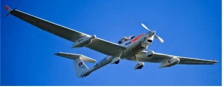
Figure 2: The SERA METAIR-DIMO (Motorglider Dia-mond Aircraft HK36-TTC-ECO, also called “ECO-Dimona”) with 16.5 m wing-span and up to 100 kg sci-entific payload, carried mainly in the under wing-pods of this special version (the two ARA-DIMOs are simi-lar).
On the other hand, small manned aircraft typically have higher payloads than their unmanned counterparts (especially in terms of cost per kg payload); the instrumentation does not necessarily need to be fully automated; they can operate nearly without restrictions (in terms of ATC and airspace) anywhere in the world; and potential system failures, in the on-board instrumentation or even in the platform itself) in most cases can be overcome by the crew.
This is obviously not a comprehensive list of similarities or differences, but illustrates the scope of the analysis required to decide whether an unmanned or manned small aerial platform would be the most advantageous option for a particular application.
Other considerations could be the availability of certain platforms to the specific research or project team; the need to test or demonstrate the capabilities of a certain technology on a specific platform; or the experience and skill of the available operating team with specific platforms.
In the following, we are discussing a few criteria. We decided that it is not possible to compile a table of pro’s and con’s. Even when we restrict ourselves to a view at the present and the near future (up to three years, no planned or unknown long-term developments), the criteria need to be discussed by more than just some scores, or keywords.
DISCUSSION
Legal constraints: From what we have learned within our UMARS project for the Swiss air space, and from international partners within COST ES0802, it is relatively easy to operate UAS’s as long as they are regarded as model airplanes, i.e. have an MTOM of less than 25 kg (most countries) or even 30 kg (Switzerland); are operated within sight (naked eye only, no optical enhancements like telescopes or binoculars allowed), and the owner of the land agrees. Autonomous flight by autopilot is possible under this regime; however, it needs a safety pilot ready to switch to manual control when, for instance, other aircraft are approaching. The basis for these rules and restrictions is “see and avoid”, in a very similar manner as for manned VFR-operations. In some countries (e.g. France) model airplanes are restricted to fly below 150 mAGL (500 ftAGL). We are aware of considerable international efforts to ease this limitation under certain conditions. It may therefore become possible to operate UASs beyond visual range; however, this may become only possible for just two types of UASs in the near future: (1) Ultra-light platforms (<0.5 kg, similar to meteorological sensors carried by balloons); and (2) sophisticated aerial systems that are capable to “detect and avoid” other air traffic reliably by other than visual means (including machine-vision). While systems of the former type do exist no systems of the latter type have been proven sufficiently to be cleared for autonomous and unrestricted operation. As most applications that are of interest to geomatics and other observational research need more than 100 grams of payload, but cannot afford to wait for, or develop “detect and avoid” technology, we will limit our subsequent considerations to UASs that can operate under the legislative framework valid for model airplanes.
Scale of the observations: Facing the legal constraints discussed above, we can conclude that most practical applications of UAS are restricted to spatial scales in the order of 1 km. However, within this range, many interesting applications with sensors of only a few kg mass are possible to fly, especially if also the flight altitude is low (limitation
depending on country). The range might be extended by more than one safety pilot, or a moving safety pilot (in a car, or even in an aircraft, following the UAS). According to the program of the conference, most projects are dealing with tasks within this range of 1 km.
Value of the payload: We have no firm statistical basis on which to judge the reliability of UAS (Unmanned Airborne System) other than that of our own (UMARS), but we are of the opinion that it is very ambitious to reduce damaging incidents in UAS operations available today to less than 1% of the number of flights. It is therefore wise to carry out an analysis of the implications that reliability of the UAS has in terms of payload damage or loss. In comparison, the statistical risk of damaging incidents during the operation of manned small aircraft is in the order of once per 10’000 flight hours, which equates to 0.01% per flight hour.
Region to fly: With manned aircraft, almost any region in Europe (or elsewhere) can be overflown. It might need a permission within some air spaces and for certain altitudes (low or high), but, completely closed air spaces are rare in Europe (none in Switzerland). There are more restrictions for model aircraft. Piloted aircraft can also operate in controlled air space which is very often the case over populated areas with a nearby airport. These are regions that are important for geomatic applications.
Accuracy of flight tracks: A flight track of an auto-piloted UAS might be more precise than that of a manually piloted small aircraft. However, this could be enhanced with part- or fully automated solutions such as a special autopilot system that augments the most commonly used flight guidance system, a GPS and/or IMU-controlled moving map display. It is also noteworthy in this context that for most geomatics applications such simple systems are sufficient for accurate data capture as long as the actual position and attitude of the platform is recorded at a high data rate using a high-precision positioning and attitude system – normally a coupled GPS/IMU system..
Time of Day: The operation of UAS’s can be extended day and night provided the noise footprint of the UAS is not prohibitive. Such operations are not realistic for manned low-altitude flying. Only transects in certain regions, on minimum altitudes of >1000mAGL, or close to illuminated airports or emergency landing field, are feasible with a manned SERA. Thus, if close-to-terrain night-flying is essential, the UAS might be the only option. Night-flying with UAS might even be a way to operate in air space that might not be accessible during daytime. However, this obviously would exclude observations requiring visible light or near IR.
Weather: Since most applications in geomatics need good visibility or prefer clear sky (as for hyperspectral scanning) the requirements and limitations are the same for both platform types. There might be applications such as radar topography missions, or other remote sensing with microwaves that are unaffected by cloud or low visibility (but usually excluding rain). However, if the condition which needs to be observed is not time-dependent (can wait until the weather is suitable for VFR-flying) this is not an accountable advantage. It could only be one if flying under adverse meteorological conditions could open air spaces which are not accessible under VMC (Visual Meteorological Conditions, similar to flying during the night).
Organisational Aspects: The idea that unmanned airborne operation is easier to perform than classical airborne measurements is mainly originating from the experience that airborne measurements need a big research aircraft operator which causes long planning processes; is expensive and not very flexible during the flight campaign (short time slots, other concurring contracts, i.e. overbooking for the weather conditions of interest, etc.). These are real problems with airborne measurements. However, a SERA operated by a small company like METAIR, or a University institute like Flinders/ARA (and other emerging groups in Europe who set up their own aircraft during the last few years) is much more flexible, and very close to the users. These operators have the necessary know-how to perform such measurements efficiently. New users who wish to have their own tool (sometimes perhaps a UAS because a manned aircraft seems to be out of reach) very often underestimate the practical problems, but overestimate the efforts (and cost!) needed for airborne measurements with a manned platform.
Cost: We know the cost for the operation of METAIR-DIMO or ARA-METAIR-DIMO quite well: The marginal cost (the difference between having the aircraft parked in the hangar and flying it, mainly fuel, engine wear and maintenance cost per hour) is less than 200 EUR/h. Adding to this the annual fixed cost (insurance, depreciation, hangar, calendar-based maintenance, etc.) divided by 100 flight hours (which is below average), the cost per flight hour is about EUR 500. If one assumes to fly 300 hours per year (which is easily possible), the total hourly cost decreases to about 300 EUR/h. If one assumes a typical “day in the field” with, say, 5 mission hours, this yields EUR 2’500 or EUR 1’500, respectively, for the aircraft alone.
If one compares this with the typical daily cost of the personnel – an absolute minimum is probably a pilot and a systems operator, but more likely a team of 3 to 4 individuals, costing of the order of EUR 1’000 to EUR 2’000 per day and person (including logistics cost and depending on the overall cost structure of the organisation) – it is immediately clear that “cost per flight hour” is not a very useful measure for SERA operations. Similar considerations are most probably also true for UASs. On the side, it is noteworthy that at least for METAIR and ARA operations, the pilot normally is also a scientist who contributes more to the field campaigns than just his or her flying skills.
So a much more realistic cost measure for both, SERAs and UAS, is the “days in the field” which also includes planning, instrument preparation, post-processing and other logistics. With this in mind, the cost for METAIR and ARA campaign days averaged over the last 20 years was between EUR 5’000 and EUR 20’000 (with the latter typical for a day of intense measurements with either complex atmospheric chemistry with a large number of measured parameters or for laser-scanning or hyper-spectral scanning applications). As a campaign using a UAS – at least under the current legislative framework - needs considerably more planning and administration, combined with the requirement of using fully automated instrumentation, it is hard to imagine that there would be any cost savings when compared to using a SERA. Obviously, if there are other factors, such as aircraft availability within certain organisations or groups which may have a strong influence on cost, or flight conditions or requirements that make it unwise or impossible to use a SERA, a UAS may be the
more suitable option, even if the overall cost is higher than that for a comparable SERA..
In the following sections, we will use these criteria and try to apply them to some examples of past and future field campaigns of ARA and METAIR that are relevant to geomatics.
SERA OR UAS – OR BOTH COMBINED – A RE-EVALUATION OF SOME FIELD CAMPAIGNS:
Two field campaigns in which METAIR or ARA have operated their small manned aerial platforms are re-analysed to give an example of the considerations that should be evaluated to decide which platform technology might be the most suitable one for a specific project. One of the projects (“TIPPEX”) was flown in 2008 in Northern Australia, while the other one (“MAIOLICA”) had flight campaigns in 2009 to 2011 in Switzerland.
TIPPEX campaign in Australia’s Outback in 2008
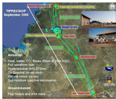
In the context of the SPECIAL project (“Savanna Patterns of Energy and Carbon Integrated Across the Landscape”), comprehensive airborne surveys were flown by both ARA-DIMOs in September 2008 under the acronym “TIPPEX”, relating to the aircraft team being based at Tipperary Station in the Northern Territory of Australia. Nearly the complete airborne toolkit available at ARA and METAIR at the time was deployed and flown along the nearly 1’000km-long North Australian Tropical Transect (NATT) as shown in Figure 3. An overview of the whole campaign is available in Beringer et al, 2011. For more details about the DIMO in general terms, see Hacker, 2011.
The airborne toolkit consisted of:
• full waveform resolving lidar (Riegl Q560)
• Hyperspectral scanner (SPECIM AISA EAGLE)
• Hi-res aerial camera (Canon EOS 1Ds)
• ARA/AWI Tri-Spectral scanner (for ndvi)
• PLMR - passive microwave radiometer (for soil moisture)
• Instrumentation for high precision measurements of CO2, CO and other gases
• Turbulent flux instrumentation (turbulent fluxes) Examples of results are shown in Figure 3, 4 and Figure 5.
Figure 3: Flights along the NATT and other features of the TIPPEX sub-campaign of SPECIAL.
The flight patterns for TIPPEX can be categorised into:
• Transects up to 1’000km long flown at between 400m and 3km AGL, carrying the remote sensing instrumentation
• Transects up to 1’000km long flown at nominally 25m AGL for determining the exchange of heat, water vapour and CO2 between the Earth’s surface and the atmosphere
• Grid patterns over specific areas typically flown at 400m AGL, carrying the remote sensing instrumentation
• Grid patterns over the same areas nominally flown at 25m AGL – as above
• Ascents/descents from very low altitudes up to 7km to determine the vertical profiles of atmospheric parameters
• Coordinated circles with 30km diameter flown simultaneously by both SERAs at between 25m and 1’000m AGL to determine the uptake of CO2 by the enclosed area on the ground.
The multitude of flight patterns and instrumentation can be analysed to see which of the tasks could have been flown by a UAS; what the capabilities of such a UAS would have to be; and what advantages/disadvantages a UAS would have had over the SERAs that were used.
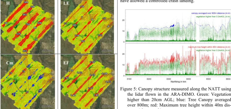
Figure 4: Aircraft flux grids (~20km) over the Daly River site (see Figure 3). For visualization, the fluxes were spatially averaged over 800m, their magnitude is illus-trated by the length of the coloured whiskers (red: up-ward fluxes, blue: downup-ward fluxes). Minimum and maximum flux values are shown for each transect. H is sensible heat flux (W/m2), LE is latent heat flux (W/m2), Cm is flux of CO2 (µmol CO2 /m2 /s), EF is evaporative fraction (LE/H+LE).The image beneath the fluxes is aircraft-derived NDVI using data from the ARA/AWI Tri-Spectral Scanner.
Long transects flown at 3km AGL: Due to the weight, space and power requirements of the remote sensing instrumentation, most of the long transects were flown with both SERAs, one closely flowing the other one. Each of the SERAs was carrying an instrumentation payload of approximately 90kg, plus one or two crew, plus near full fuel to cover the very long distances. This requires a load carrying capacity of approximately 300kg (payload, crew, fuel).
Assuming that the payload and fuel quantities would be similar, a UAS flying the same mission, would have to be able to carry approximately 130kg (instrumentation plus fuel). This requires a UAS of similar size to the DIMOs. If a
DIMO could be flown in a UAS-mode, the weight of the crew could either be replaced by additional instrumentation or by more fuel, both of which would be advantageous for projects of this type. However, it would have been close to impossible – under the given legislative restrictions – to fly the required missions, even as most of the transect was located in remote parts of Northern Australia which has very thin air traffic. In fact, during all missions, we never saw any other aircraft.
Long transects flown at 25m AGL: The scientific instrumentation required for the long transects flown at very low altitude weighed less than 20kg with the potential to weigh even less by using slightly updated technology. The flying conditions for these transects were extremely demanding for the crew (and basically also for the instrumentation and the aircraft) – OAT sometimes above 40ºC, no cockpit air conditioning, very turbulent atmosphere with up- and downdrafts of up to 8m/s, sometimes dusty conditions; no auto-pilot. In addition there were basically no landing areas available for most of the transect, except patches of cleared vegetation that would have allowed a controlled crash landing.
Figure 5: Canopy structure measured along the NATT using the lidar flown in the ARA-DIMO. Green: Vegetation higher than 20cm AGL; blue: Tree Canopy averaged over 800m; red: Maximum tree height within 40m dis-tance (along track).
On first sight, this thus sounds like a UAS-application – the payload requirements could be accommodated by relatively small UAS, provided they have at least 5 hours endurance. The flight control requirements could also possibly be achieved by a highly intelligent automatic system capable of coping with – and applying - high dynamic manoeuvres. As the area has very sparse mobile phone coverage, the UAS would either have to be controlled through a satellite link or operate fully autonomously. This leaves the question of legal requirements. As the flight path would be more or less fixed and never exceed 25m AGL, it probably would have been possible to get an exemption from the Australian authorities for this operation.
However – and this is purely based on many years of personal experience in this kind of operation – it was extremely valuable for the subsequent interpretation of the data from these flights for the scientist/pilot to actually be in the aircraft and in that way gain a direct impression of the landscape and the atmospheric conditions – something that even the best visualisation or animation cannot achieve.
Whether the use of a UAS would have been a more cost-efficient solution in this case is very difficult to assess. Our guess is that the cost differential in either way would have been small.
H LE
Cm EF
In terms of overall safety considerations it is clear that an approach eliminating the crew has advantages, but the judgement about what level of safety is acceptable for specific operations is beyond this analysis.
Grid patterns: Similar consideration can be applied to the two types of grid patterns, although it probably would have been simpler to gain an exemption from the Australian authorities to operate a UAS over these limited areas, although substantial ferry flights were involved to get there which therefore may have eliminated this advantage.
Ascents/descents: The ascents/descents were flown to the East and West of Darwin with its international airport. Although the traffic volume at Darwin Airport is certainly much lower than at many other airports in Australia and around the world, there is a considerable number of RPT-type VFR-operations using single and twin-engine aircraft. It is therefore doubtful that a permission to fly a UAS would have been easy to get in this area.
Operationally and in terms of safety it is not obvious what advantages a UAS would have offered.
Simultaneous Circles: As both DIMOs were only carrying a comparatively light instrumentation package (<25kg); the area of the circles was located in a remote area close to the operations base with nearly no other air traffic; and a highly synchronous flight path was required, this is the pattern where probably a “team” of two identical UASs could have been used at the greatest advantage. In fact, if such UASs would have been available to the science team, it would have had the added advantage that the pattern could have been flown many more times, even at night (which was impossible to do with the DIMOs), without having to use up valuable DIMO-time from the other patterns.
MAIOLICA campaigns in Switzerland in 2009 to 2011
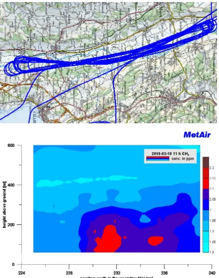
In 2009 and 2010, the METAIR-DIMO flew repeated (21 days) cross sections in the Reuss Valley north of Cham in the framework of ETH/CCES MAIOLICA (ETH, 2010; Eugster et al., 2010). One of the core questions is the distribution and the vertical turbulent fluxes of the greenhouse gas Methane (CH4) over areas of different land use, animal density, and other emission sources. Both, this project in the Reuss Valley, and also excursions to a reservoir lake (Hiller et al. 2010a and 2010b) are very good examples of projects that could be extended as a combined mission of a UAS flying in tandem a manned SERA – in this case the UAS would cover flying altitudes below the SERA. Within the COST-action ES0802 we call this the HUMANO concept (Hybrid Unmanned and MANned Observations).
Figure 6 shows the typical repeated flight tracks at altitudes between 600 mAGL down to 50 mAGL, crossing the research Station “Chamau” of ETHZ where additional ground based sensors were installed. Below the 50 m (or rather the 100 mAGL because 50 mAGL was not possible everywhere) there is a gap, where both the turbulence and the concentrations of CH4 are very inhomogeneous. There even is a major gap in 4-d (time) because this pattern was interrupted for several hours. During daytime, other excursions were flown; no flights were possible at nighttime. It would be most interesting to fill these gaps with an UAS. At this time, there are no CH4 sensors of sufficient accuracy and time resolution available to fit into UMARS. However, other parameters such as the 3-d turbulent wind, temperature, water vapour (humidity), CO2, NO2 and aerosols can be measured by existing and available
technology in a <10 kg package. We plan to start first joint flights (with the meteorological parameters only) by the end of August 2011 (just before the UAS-g Workshop), where UMARS will operate within 1 km around “Chamau”. We hope to be able to report about these first experiences at the Workshop.
Figure 6: Flight along a south-north cross section of about 16 km length at altitudes between 600 mAGL down to 50 mAGL. North is on the right-hand side on the map (Source: Bundesamt für Landestopografie, via on-board moving map Fugawi) and on the cross section showing the vertical distribution of CH4 along the transects (col-our scale from 1.8 to 2.2 ppm)
Figure 7: Simple aerial photo as a place holder for any down looking imaging in one of the under wing pods. In this case, actual land use was documented – fertilizing the field using a slurry spreader).
In addition to the atmospheric measurements, nadir-looking images were also taken. This allowed, for instance,. to identify fields where slurry was distributed during the flights. Such photography could easily be delegated to a UAS freeing up the SERA for other tasks. On the other hand, it is a trivial task to fly the aerial camera in one of the underwing pods of the DIMO together with the more advanced cameras or scanners (IR, NDVI, etc) and link it to the very precise geo-referencing using a high-grade IMU/GPS (OXTS RT3102 on METAIR-DIMO, OXTS RT4003 in ARA-DIMO).
CONCLUSION AND OUTLOOK
UAS and SERA have many common aspects which could lead to more universal instrumentation for both, which then could even be used in joint campaigns where in some regions of 4-d (small scale <1 km, night-time, close to the ground, very repetitive) UAS are the first choice, whereas for many applications which are also increasingly associated with UAS, SERA might still be the more efficient choice. It was our intention to show a few examples and to discuss METAIRs and ARAs 30 years of experience with SERA and two years of new experience with our UAS “UMARS”. There is no doubt that the trend is heading towards using UAS for just about anything, progress might be more cost-efficient and faster when the synergies between both types of platforms are realised.
We intend to fly UAS campaigns as outlined above in the near future, which can be summarised as follows:
Small scale (<2 km horizontal, up to 1000 mAGL when stand-alone, rather below 300 mAGL when in combination with manned aircraft) with relatively inexpensive sensors.
The same (stand-alone UAS operation) during night.
Within the next two or three years it should also be possible to achieve:
High-altitude flights at night, in airspace without VFR- and limited IFR-traffic, coordinated by ATC, after careful evaluation of risks and failsafe procedures, resulting in a permission to fly.
Combined flights with the DIMO and an UAS in sight from the operator in the DIMO, where the UAS will serve as a second sensor platform enabling to measure gradients, or carrying a dedicated reflector for better defined spectroscopy than is possible with reflection of sunlight from the ground.
Combined flights the DIMO and an UAS, where the DIMO carries heavier, more expensive remote sensing equipment like laser scanner and hyperspectral scanner, and the UAS carries sensors relevant for the atmospheric correction of the remotely-sensed parameters, or takes high-resolution images close to the surface (for instance, to document the size distribution of gravel along a river).
We are working on miniaturising further the instrumen-tation flown in the under wing pods of the DIMOs so that they can also be flown in UMARS. Initial candidates are sensors for. CO2, NO2 & NOx, as well as particle counters). A new turbulence probe with a 5-hole hemisphere, an xsens IMU, and fast sensors for temperature and humidity is already operational and installed on UMARS. We call it Z_probe (Zurich-probe). It is suitable both for UAS and manned aircraft. This was the first miniaturised sensor for UMARS which, in fact, is now also used on the DIMO. This offers us the opportunity to also compare and verify the inertial measurements from the small and low-cost xsens IMU, as well as the very small and inexpensive IMU from the paparazzi autopilot against the higher grade OXTS RT3102 GPS/IMU.
Regarding new instrumentation and sensors that can be useful for both, UAS and SERA installation, it should become common practice to design them right from the start for a deployment on both types of platforms without further modification. The more such universal compact sensor packages become available, the more both communities can
profit from them, bringing more flexibility to small user groups.
Such cooperation would also allow to safely test-fly any equipment that was developed for a UAS in one of our under wing pods or similar installations.
ACKNOWLEDGEMENTS
The development of UMARS was enabled with internal funding from the School of Engineering of ZHAW (the Zurich University of Applied Sciences) in Winterthur, and with additional Swiss federal funding (SBF/COST C10.0149) within the framework of COST action ES0802. METAIR-DIMO is funded by diverse customers and partners like ETH Zurich (CCES) and the Research Centre Jülich, Germany.
ARA itself, the ARA DIMOs and their instrumentation were funded by a combination of donations from the late Joyce and Don Schultz of Glen Osmond, South Australia; the Australian Research Council and other Australian grant schemes, as well as by contributions from the many Australian and international users of ARA’s capabilities.
References
Beringer, J., J.M. Hacker, L.B. Hutley, S.K. Arndt, R. Amiri, L. Bannehr, L. Cernusak, S. Grover, C. Hensley, D. Hocking, P. Isaac, H. Jamali, K. Kanniah, S. Livesley, B. Neininger, Kyaw Tha Paw U, W. Sea, D. Straten, N. Tapper, R. Weinmann, S. Wood, S. Zegelin, R. Leuning, 2011. SPECIAL – The Savanna Patterns of Energy and Carbon Integrated Across the Landscape campaign. Accepted for publication in the Bulletin of American Meteorological Society (Acceptance Date: 2 Jun 2011).
ETH, 2010. CCES MAIOLICA
http://www.gl.ethz.ch/research/projects/MAIOLICA (accessed 20.07.2011).
Hacker, J.M., 2011. Airborne Remote Sensing In Australia Using Small, Modern, Highly Cost-Efficient Platforms - Capabilities And Examples. 34th International Symposium on Remote Sensing of Environment, Sydney, 10-15Apr 2011, Sydney, Australia. Available on-line as
www.airborneresearch.com.au/ISRSE2011_JMH.pdf
Hiller R., W. Eugster, D. Brunner, B. Buchmann, L. Emmenegger, B. Neininger, C. Schubert, E. Hodson, J. Stieger, N. Buchmann, 2010b. Regional Integration Experiment. Poster at Latsis Symposium,
ETH Zurich, 15.-17. Nov. 2010,
http://www.metair.ch/media/poster/CCES_Latsis2010_Aciti vity1a.pdf (accessed 20.07.2011)
Eugster W., R. Hiller, D. Brunner, B. Tuzson, B.
Buchmann, L. Emmenegger, B. Neininger, C. Schubert, E. Hodson, J. Stieger, N. Buchmann, 2010. Land Ecosystem Experiments. Poster at Latsis Symposium, ETH Zurich, 15.-17. Nov. 2010,
http://www.metair.ch/media/poster/CCES_Latsis2010_Aciti vity1c.pdf (accessed 20.07.2011)
Hiller R, Neininger B, Del Sontro T, Diem T, Buchmann N, Eugster W, 2010a, Methane efflux of Lake Wohlen, Poster at Swiss Global Change Day, Bern, 20.4.10